Worldwide Airfield Summary
 Sample cover page
The Worldwide Airfield Summary contains a selection of climatological data produced by the U.S. Air Force, Air Weather Service. The reports were compiled from dozens of domestic and international sources. It consists of summaries for approximately 4,000 airfield stations worldwide and the climatic areas in which they are located, for various periods ending at or before May 1974. A keyed subset (June 1969) is available digitally upon request.
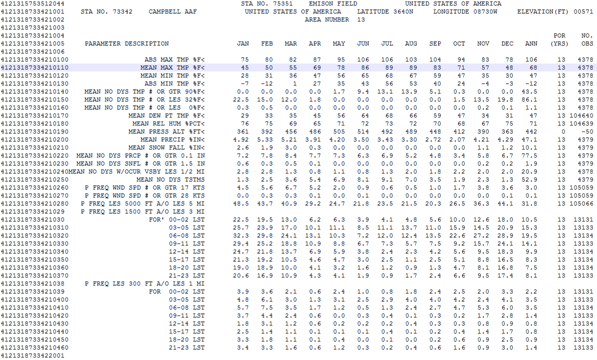
The data presented are monthly and annual summaries of: 1. Absolute maximum and minimum temperatures (Deg. F), 2. Mean daily maximum and minimum temperatures (Deg. F), 3. Mean number of days with maximum temperature equal to or greater than 90 Deg. F, 4. Mean number of days with minimum temperature equal to or less than 32 or 0 Deg. F, 5. Mean dew-point temperature (Deg. F), 6. Mean relative humidity (%), 7. Mean pressure altitude (feet), 8. Mean precipitation (in.), 9. Mean snowfall (in.), 10. Mean number of days with precipitation equal to or greater than 0.1 inch, 11. Mean number of days with snowfall equal to or greater than 1.5 inch, 12. Mean number of days with an occurrence of visibility less than 0.5 mile, 13. Mean number of days with thunderstorms, 14. Percent frequency surface wind speed equal to or greater than 17 knots, 15. Percent frequency surface wind speed equal to or greater than 28 knots, 16. Percent frequency ceiling less than 5,000 feet and/or visibility less than 5 miles, 17. Percent frequency ceiling less than 1,500 feet and/or visibility less than 3 miles by 3-hourly increments, 18. Percent frequency ceiling less than 300 feet and/or visibility less than 1 mile by 3-hourly increments, 19. Mean number of days with ceiling equal to or greater than 1,000 feet and visibility equal to or greater than 3 miles, 20. Mean number of days with ceiling equal to or greater than 2,500 feet and visibility equal to or greater than 3 miles, 21. Mean number of days with ceiling equal to or greater than 6,000 feet and visibility equal to or greater than 3 miles, 22. Mean number of days with ceiling equal to or greater than 10,000 feet and visibility equal to or greater than 3 miles, 23. Mean number of days ceiling equal to or greater than 2,000 feet and visibility equal to or greater than 3 miles with surface wind speed less than 10 knots, 24. Mean number of days with surface wind speed equal to or greater than 17 knots and no precipitation, 25. Mean number of days with surface wind speed 4 to 10 knots and temperature 33 to 89 Deg. F and no precipitation, 26. Mean number of days with sky cover less than 3/10ths and visibility equal to or greater than 3 miles.
The data presented are monthly and annual summaries of: 1. Absolute maximum and minimum temperatures (Deg. F), 2. Mean daily maximum and minimum temperatures (Deg. F), 3. Mean number of days with maximum temperature equal to or greater than 90 Deg. F, 4. Mean number of days with minimum temperature equal to or less than 32 or 0 Deg. F, 5. Mean dew-point temperature (Deg. F), 6. Mean relative humidity (%), 7. Mean pressure altitude (feet), 8. Mean precipitation (in.), 9. Mean snowfall (in.), 10. Mean number of days with precipitation equal to or greater than 0.1 inch, 11. Mean number of days with snowfall equal to or greater than 1.5 inch, 12. Mean number of days with an occurrence of visibility less than 0.5 mile, 13. Mean number of days with thunderstorms, 14. Percent frequency surface wind speed equal to or greater than 17 knots, 15. Percent frequency surface wind speed equal to or greater than 28 knots, 16. Percent frequency ceiling less than 5,000 feet and/or visibility less than 5 miles, 17. Percent frequency ceiling less than 1,500 feet and/or visibility less than 3 miles by 3-hourly increments, 18. Percent frequency ceiling less than 300 feet and/or visibility less than 1 mile by 3-hourly increments, 19. Mean number of days with ceiling equal to or greater than 1,000 feet and visibility equal to or greater than 3 miles, 20. Mean number of days with ceiling equal to or greater than 2,500 feet and visibility equal to or greater than 3 miles, 21. Mean number of days with ceiling equal to or greater than 6,000 feet and visibility equal to or greater than 3 miles, 22. Mean number of days with ceiling equal to or greater than 10,000 feet and visibility equal to or greater than 3 miles, 23. Mean number of days ceiling equal to or greater than 2,000 feet and visibility equal to or greater than 3 miles with surface wind speed less than 10 knots, 24. Mean number of days with surface wind speed equal to or greater than 17 knots and no precipitation, 25. Mean number of days with surface wind speed 4 to 10 knots and temperature 33 to 89 Deg. F and no precipitation, 26. Mean number of days with sky cover less than 3/10ths and visibility equal to or greater than 3 miles.
Dataset Citation
- Cite this dataset when used as a source.
Dataset Identifiers
- NCEI DSI 9647_01
- NCEI Physical Archive Collection: WWAS
- gov.noaa.ncdc:C00029
ISO 19115-2 Metadata
gov.noaa.ncdc:C00029
| Distribution Formats |
|
| Ordering Instructions | Contact NCEI for other distribution options and instructions. |
| Distributor |
NOAA National Centers for Environmental Information ncei.info@noaa.gov |
| Dataset Point of Contact | Customer Engagement Branch NOAA National Centers for Environmental Information 1-828-271-4800 ncei.orders@noaa.gov |
| Time Period | 1901-01-01 to 1974-05-01 |
| Spatial Bounding Box Coordinates |
West: -180.0
East: 180.0
South: -90.0
North: 90.0
|
| Spatial Coverage Map |
| General Documentation |
|
| Publication Dates |
|
| Data Presentation Form | Hardcopy image - image archived in analog format |
| Dataset Progress Status | Historical archive - data has been stored in an offline storage facility |
| Data Update Frequency | Not planned |
| Purpose | International climatological summaries provide a global view of the world's climate. |
| Dataset Citation |
|
| Cited Authors |
|
| Originators |
|
| Collaborators |
|
| Publishers |
|
| Theme keywords |
Global Change Master Directory (GCMD) Science Keywords
|
| Data Center keywords |
Global Change Master Directory (GCMD) Data Center Keywords
|
| Platform keywords |
Global Change Master Directory (GCMD) Platform Keywords
|
| Instrument keywords |
Global Change Master Directory (GCMD) Instrument Keywords
|
| Place keywords |
Global Change Master Directory (GCMD) Location Keywords
|
| Stratum keywords |
Global Change Master Directory (GCMD) Location Keywords
|
| Use Constraints |
|
| Access Constraints |
|
| Fees |
|
| Lineage information for: dataset | |
|---|---|
| Lineage Statement | Data was compiled from dozens of domestic and international sources by the United States Air Force Air Weather Service. All sources are listed in each publication. These summaries were prepared by U.S. Air Force Environmental Technical Applications Center (ETAC) for the U.S. Naval Oceanography Command. |
| Lineage information for: repository | |
|---|---|
| Processing Steps |
|
| Acquisition Information (collection) | |
|---|---|
| Instrument |
|
| Platform |
|
Last Modified: 2023-09-07
For questions about the information on this page, please email: ncei.info@noaa.gov
For questions about the information on this page, please email: ncei.info@noaa.gov