Radar Chart
(MI_Metadata)
fileIdentifier: gov.noaa.ncdc:C00104
language: eng; USA
characterSet: (MD_CharacterSetCode) utf8
hierarchyLevel: (MD_ScopeCode) dataset
contact: (CI_ResponsibleParty)
organisationName: NOAA National Centers for Environmental Information
contactInfo: (CI_Contact)
address: (CI_Address)
electronicMailAddress: ncei.info@noaa.gov
onlineResource: (CI_OnlineResource)
linkage: https://www.ncei.noaa.gov/contact
name: NCEI Contact Information
description: Information for contacts at NCEI.
function: (CI_OnLineFunctionCode) information
role: (CI_RoleCode) pointOfContact
dateStamp: 2023-07-11
metadataStandardName: ISO 19115-2 Geographic Information - Metadata - Part 2: Extensions for Imagery and Gridded Data
metadataStandardVersion: ISO 19115-2:2009(E)
return to top
identificationInfo: (MD_DataIdentification)
citation: (CI_Citation)
title: Radar Chart
date: (CI_Date)
date: (unknown)
dateType: (CI_DateTypeCode) publication
identifier: (MD_Identifier)
code: NCEI Physicals: CHTRAD
identifier: (MD_Identifier)
code: gov.noaa.ncdc:C00104
citedResponsibleParty: (CI_ResponsibleParty)
organisationName: DOC/NOAA/NESDIS/NCEI > National Centers for Environmental Information, NESDIS, NOAA, U.S. Department of Commerce
role: (CI_RoleCode) publisher
citedResponsibleParty: (CI_ResponsibleParty)
organisationName: DOC/NOAA/NESDIS/NCDC > National Climatic Data Center, NESDIS, NOAA, U.S. Department of Commerce
positionName: User Engagement and Services Branch
contactInfo: (CI_Contact)
phone: (CI_Telephone)
voice: +1 (828) 271-4800
facsimile: +1 (828) 271-4876
address: (CI_Address)
deliveryPoint: 151 Patton Avenue
deliveryPoint: Veach-Baley Federal Building, Room 468
city: Asheville
administrativeArea: NC
postalCode: 28801-5001
country: USA
electronicMailAddress: ncei.orders@noaa.gov
hoursOfService: 8:00 - 6:00 Eastern
role: (CI_RoleCode) publisher
citedResponsibleParty: (CI_ResponsibleParty)
organisationName: DOC/NOAA/NWS/NCEP > National Centers for Environmental Prediction, National Weather Service, NOAA, U.S. Department of Commerce
role: (CI_RoleCode) originator
citedResponsibleParty: (CI_ResponsibleParty)
organisationName: DOC/NOAA/NWS/NCEP > National Centers for Environmental Prediction, National Weather Service, NOAA, U.S. Department of Commerce
role: (CI_RoleCode) author
presentationForm: (CI_PresentationFormCode) mapDigital
presentationForm: (CI_PresentationFormCode) imageHardcopy
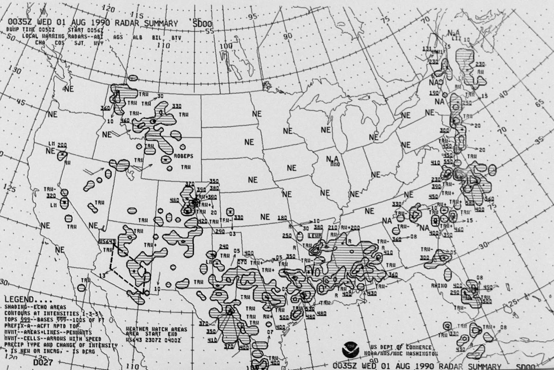
abstract: The Radar Chart collection is an archived product of summarized radar data. The geographic coverage is the 48 contiguous states of the United States. These hourly radar charts were prepared by the National Weather Service (NWS) and the National Centers for Environmental Prediction. Data contains analyzed areas, lines, and cells of cloud formations that include the base, tops, movement, and precipitation intensity. Precipitation types and change of intensity are also depicted. These charts are prepared from radar observations taken by NWS weather radar stations throughout the country.
purpose: To make a wide range of climatic data available to researchers and the public.
status: (MD_ProgressCode) historicalArchive
pointOfContact: (CI_ResponsibleParty)
organisationName: NOAA National Centers for Environmental Information
positionName: Customer Engagement Branch
contactInfo: (CI_Contact)
phone: (CI_Telephone)
voice: 1-828-271-4800
facsimile: 1-828-271-4876
address: (CI_Address)
deliveryPoint: 151 Patton Avenue
deliveryPoint: Veach-Baley Federal Building, Room 468
city: Asheville
administrativeArea: NC
postalCode: 28801-5001
country: USA
electronicMailAddress: ncei.orders@noaa.gov
onlineResource: (CI_OnlineResource)
linkage: https://www.ncei.noaa.gov
protocol: HTTPS
applicationProfile: Web Browser
name: NOAA National Centers for Environmental Information (NCEI)
description: NCEI home page with information, data access and contact information.
function: (CI_OnLineFunctionCode) information
hoursOfService: 8:00 - 6:00 Eastern
role: (CI_RoleCode) pointOfContact
resourceMaintenance: (MD_MaintenanceInformation)
maintenanceAndUpdateFrequency: (MD_MaintenanceFrequencyCode) asNeeded
graphicOverview: (MD_BrowseGraphic)
fileName: https://www.ncei.noaa.gov/pub/data/metadata/images/C00104-CHTRAD.jpg
fileDescription: Sample image of Radar Summary Chart
fileType: PDF
descriptiveKeywords: (MD_Keywords)
keyword: Earth Science > Atmosphere > Clouds > Cloud Properties > Cloud Frequency
keyword: Earth Science > Atmosphere > Clouds > Cloud Properties > Cloud Asymmetry
keyword: Earth Science > Atmosphere > Clouds > Cloud Properties > Cloud Ceiling
keyword: Earth Science > Atmosphere > Clouds > Cloud Properties > Cloud Height
keyword: Earth Science > Atmosphere > Clouds > Cloud Reflectance
keyword: Earth Science > Atmosphere > Precipitation > Solid Precipitation > Hail
keyword: Earth Science > Atmosphere > Precipitation > Precipitation Rate
keyword: Earth Science > Atmosphere > Precipitation > Liquid Precipitation > Rain
keyword: Earth Science > Atmosphere > Precipitation > Solid Precipitation > Ice Pellets > Sleet
keyword: Earth Science > Atmosphere > Precipitation > Solid Precipitation > Snow
keyword: Earth Science > Spectral/Engineering > Radar > Radar Backscatter
keyword: Earth Science > Spectral/Engineering > Radar > Radar Imagery
keyword: Earth Science > Spectral/Engineering > Radar > Radar Reflectivity
type: (MD_KeywordTypeCode) theme
thesaurusName: (CI_Citation)
title: Global Change Master Directory (GCMD) Science Keywords
date: (CI_Date)
date: 2018
dateType: (CI_DateTypeCode) revision
edition: Version 8.6
citedResponsibleParty: (CI_ResponsibleParty)
organisationName: Global Change Data Center, Science and Exploration Directorate, Goddard Space Flight Center (GSFC) National Aeronautics and Space Administration (NASA)
contactInfo: (CI_Contact)
onlineResource: (CI_OnlineResource)
linkage: https://earthdata.nasa.gov/about/gcmd/global-change-master-directory-gcmd-keywords
protocol: HTTPS
applicationProfile: Web Browser
name: Global Change Master Directory (GCMD) Keywords
description: The information provided on this page seeks to define how the GCMD Keywords are structured, used and accessed. It also provides information on how users can participate in the further development of the keywords.
function: (CI_OnLineFunctionCode) information
role: (CI_RoleCode) publisher
descriptiveKeywords: (MD_Keywords)
keyword: Continent > North America > United States Of America
type: (MD_KeywordTypeCode) place
thesaurusName: (CI_Citation)
title: Global Change Master Directory (GCMD) Location Keywords
date: (CI_Date)
date: 2018
dateType: (CI_DateTypeCode) revision
edition: Version 8.6
citedResponsibleParty: (CI_ResponsibleParty)
organisationName: Global Change Data Center, Science and Exploration Directorate, Goddard Space Flight Center (GSFC) National Aeronautics and Space Administration (NASA)
contactInfo: (CI_Contact)
onlineResource: (CI_OnlineResource)
linkage: https://earthdata.nasa.gov/about/gcmd/global-change-master-directory-gcmd-keywords
protocol: HTTPS
applicationProfile: Web Browser
name: Global Change Master Directory (GCMD) Keywords
description: The information provided on this page seeks to define how the GCMD Keywords are structured, used and accessed. It also provides information on how users can participate in the further development of the keywords.
function: (CI_OnLineFunctionCode) information
role: (CI_RoleCode) publisher
descriptiveKeywords: (MD_Keywords)
keyword: Earth Science > Land Surface
keyword: Vertical Location > Troposphere
keyword: Vertical Location > Stratosphere
type: (MD_KeywordTypeCode) stratum
thesaurusName: (CI_Citation)
title: Global Change Master Directory (GCMD) Location Keywords
date: (CI_Date)
date: 2018
dateType: (CI_DateTypeCode) revision
edition: Version 8.6
citedResponsibleParty: (CI_ResponsibleParty)
organisationName: Global Change Data Center, Science and Exploration Directorate, Goddard Space Flight Center (GSFC) National Aeronautics and Space Administration (NASA)
contactInfo: (CI_Contact)
onlineResource: (CI_OnlineResource)
linkage: https://earthdata.nasa.gov/about/gcmd/global-change-master-directory-gcmd-keywords
protocol: HTTPS
applicationProfile: Web Browser
name: Global Change Master Directory (GCMD) Keywords
description: The information provided on this page seeks to define how the GCMD Keywords are structured, used and accessed. It also provides information on how users can participate in the further development of the keywords.
function: (CI_OnLineFunctionCode) information
role: (CI_RoleCode) publisher
descriptiveKeywords: (MD_Keywords)
keyword: DOC/NOAA/NESDIS/NCEI > National Centers for Environmental Information, NESDIS, NOAA, U.S. Department of Commerce
keyword: DOC/NOAA/NESDIS/NCDC > National Climatic Data Center, NESDIS, NOAA, U.S. Department of Commerce
type: (MD_KeywordTypeCode) dataCentre
thesaurusName: (CI_Citation)
title: Global Change Master Directory (GCMD) Data Center Keywords
date: (CI_Date)
date: 2018
dateType: (CI_DateTypeCode) revision
edition: Version 8.6
citedResponsibleParty: (CI_ResponsibleParty)
organisationName: Global Change Data Center, Science and Exploration Directorate, Goddard Space Flight Center (GSFC) National Aeronautics and Space Administration (NASA)
contactInfo: (CI_Contact)
onlineResource: (CI_OnlineResource)
linkage: https://earthdata.nasa.gov/about/gcmd/global-change-master-directory-gcmd-keywords
protocol: HTTPS
applicationProfile: Web Browser
name: Global Change Master Directory (GCMD) Keywords
description: The information provided on this page seeks to define how the GCMD Keywords are structured, used and accessed. It also provides information on how users can participate in the further development of the keywords.
function: (CI_OnLineFunctionCode) information
role: (CI_RoleCode) publisher
resourceConstraints: (MD_LegalConstraints)
accessConstraints: (MD_RestrictionCode) otherRestrictions
otherConstraints: Distribution liability: NOAA and NCEI make no warranty, expressed or implied, regarding these data, nor does the fact of distribution constitute such a warranty. NOAA and NCEI cannot assume liability for any damages caused by any errors or omissions in these data. If appropriate, NCEI can only certify that the data it distributes are an authentic copy of the records that were accepted for inclusion in the NCEI archives.
resourceConstraints: (MD_LegalConstraints)
useConstraints: (MD_RestrictionCode) otherRestrictions
otherConstraints: Use liability: NOAA and NCEI cannot provide any warranty as to the accuracy, reliability, or completeness of furnished data. Users assume responsibility to determine the usability of these data. The user is responsible for the results of any application of this data for other than its intended purpose.
resourceConstraints: (MD_LegalConstraints)
accessConstraints: (MD_RestrictionCode) otherRestrictions
otherConstraints: Only a subset of the data are available digitally. Please contact Customer Support to coordinate options for accessing the non-digital data. Charges may apply.
language: eng; USA
topicCategory: (MD_TopicCategoryCode) climatologyMeteorologyAtmosphere
extent: (EX_Extent)
geographicElement: (EX_GeographicBoundingBox)
westBoundLongitude: -125.0
eastBoundLongitude: -66.0
southBoundLatitude: 24.0
northBoundLatitude: 50.0
temporalElement: (EX_TemporalExtent)
extent:
TimePeriod:
beginPosition: 1956-04-19
endPosition: 2013-06-11
return to top
contentInfo: (MD_FeatureCatalogueDescription)
includedWithDataset: (missing)
featureCatalogueCitation: (CI_Citation)
title: Entity and Attribute Overview: Radar Chart are charts depicting cloud and precipitation fields and are available from the archive.
date: (inapplicable)
otherCitationDetails: Entity and Attribute Detail Citation: None
return to top
distributionInfo: (MD_Distribution)
distributor: (MD_Distributor)
distributorContact: (CI_ResponsibleParty)
organisationName: NOAA National Centers for Environmental Information
contactInfo: (CI_Contact)
address: (CI_Address)
electronicMailAddress: ncei.info@noaa.gov
onlineResource: (CI_OnlineResource)
linkage: https://www.ncei.noaa.gov/contact
name: NCEI Contact Information
description: Information for contacts at NCEI.
function: (CI_OnLineFunctionCode) information
role: (CI_RoleCode) distributor
distributionOrderProcess: (MD_StandardOrderProcess)
fees: In most cases, electronic downloads of the data are free. However, fees may apply for custom orders, data certifications, copies of analog materials, and data distribution on physical media.
orderingInstructions: Contact NCEI for other distribution options and instructions.
distributorFormat: (MD_Format)
name: XML
version: (missing)
distributorFormat: (MD_Format)
name: GIF
version: (missing)
distributorFormat: (MD_Format)
name: Microfilm
version: (missing)
distributorFormat: (MD_Format)
name: Paper
version: (missing)
distributorFormat: (MD_Format)
name: PDF
version: (missing)
distributorTransferOptions: (MD_DigitalTransferOptions)
onLine: (CI_OnlineResource)
linkage: https://www.ncei.noaa.gov/metadata/geoportal/rest/metadata/item/gov.noaa.ncdc:C00104/html
protocol: HTTPS
applicationProfile: Landing Page
name: NCEI Dataset Landing Page
description: Landing page for the dataset.
function: (CI_OnLineFunctionCode) information
distributorTransferOptions: (MD_DigitalTransferOptions)
onLine: (CI_OnlineResource)
linkage: https://www.ncei.noaa.gov/contact
protocol: HTTPS
applicationProfile: Web Browser
name: Contact NCEI
description: Contact NCEI for more information and to request access to the archived data. Requests are subject to NCEI order fulfillment constraints.
function: (CI_OnLineFunctionCode) offline
distributorTransferOptions: (MD_DigitalTransferOptions)
transferSize:
Real: 1
onLine: (CI_OnlineResource)
linkage: https://www.ncei.noaa.gov/pub/data/metadata/documents/C00104_RadarPPIuserGuide.pdf
protocol: HTTPS
applicationProfile: Web Browser
name: Documentation
description: General information about how to use radar film.
function: (CI_OnLineFunctionCode) information
return to top
dataQualityInfo: (DQ_DataQuality)
scope: (DQ_Scope)
level: (MD_ScopeCode) dataset
extent: #boundingExtent
lineage: (LI_Lineage)
statement: Data derives from radar images captured by the National Weather Bureau and, later, the National Weather Service. Some data is of poor quality and records may be incomplete.
processStep: (LE_ProcessStep)
description: Manual creation of Radar Charts.
dateTime: (missing)
processor: (CI_ResponsibleParty)
organisationName: DOC/NOAA/NWS/NCEP > National Centers for Environmental Prediction, National Weather Service, NOAA, U.S. Department of Commerce
role: (CI_RoleCode) processor
source: sd001
source: sd002
processStep: (LE_ProcessStep)
description: Automated creation of Radar Charts.
dateTime: (missing)
processor: (CI_ResponsibleParty)
organisationName: DOC/NOAA/NWS/NCEP > National Centers for Environmental Prediction, National Weather Service, NOAA, U.S. Department of Commerce
role: (CI_RoleCode) processor
source: sd003
source: (LE_Source)
description: NWS observers used Radar PPI scopes in conjunction with the Radar Weather Observations to analyze then compile the information to create radar summary charts charts.
sourceCitation: (CI_Citation)
title: Radar Plan Position Indicator Scope
date: (missing)
identifier: (MD_Identifier)
code: gov.noaa.ncdc:C00133
citedResponsibleParty: (CI_ResponsibleParty)
organisationName: DOC/NOAA/NESDIS/NCEI > National Centers for Environmental Information, NESDIS, NOAA, U.S. Department of Commerce
role: (CI_RoleCode) publisher
citedResponsibleParty: (CI_ResponsibleParty)
organisationName: (missing)
contactInfo: (CI_Contact)
onlineResource: (CI_OnlineResource)
linkage: https://www.ncei.noaa.gov/metadata/geoportal/rest/metadata/item/gov.noaa.ncdc:C00133/html
protocol: HTTPS
applicationProfile: Web Browser
name: Radar Plan Position Indicator Scope
description: More information for source data can be found at the dataset landing page.
function: (CI_OnLineFunctionCode) information
role: (missing)
sourceExtent: (EX_Extent)
temporalElement: (EX_TemporalExtent)
extent:
TimePeriod:
beginPosition: 1951-01-01
endPosition: 1997-08-31
sourceStep: ps001
source: (LE_Source)
description: NWS observers used Radar PPI scopes in conjunction with the Radar Weather Observations to analyze then compile the information to create radar summary charts charts.
sourceCitation: (CI_Citation)
title: Radar Weather Observations
date: (missing)
identifier: (MD_Identifier)
code: gov.noaa.ncdc:C00134
citedResponsibleParty: (CI_ResponsibleParty)
organisationName: DOC/NOAA/NESDIS/NCEI > National Centers for Environmental Information, NESDIS, NOAA, U.S. Department of Commerce
role: (CI_RoleCode) publisher
citedResponsibleParty: (CI_ResponsibleParty)
organisationName: (missing)
contactInfo: (CI_Contact)
onlineResource: (CI_OnlineResource)
linkage: https://www.ncei.noaa.gov/metadata/geoportal/rest/metadata/item/gov.noaa.ncdc:C00134/html
protocol: HTTPS
applicationProfile: Web Browser
name: Radar Weather Observations
description: More information for source data can be found at the dataset landing page.
function: (CI_OnLineFunctionCode) information
role: (missing)
sourceExtent: (EX_Extent)
temporalElement: (EX_TemporalExtent)
extent:
TimePeriod:
beginPosition: 1951-01-01
endPosition: 1997-08-31
sourceStep: ps001
source: (LE_Source)
description: NOAA Next Generation Radar (NEXRAD) Level II Base Data
sourceCitation: (CI_Citation)
title: Weather Radar (Level II) Landing Page
date: (missing)
identifier: (MD_Identifier)
code: doi:10.7289/V5W9574V
citedResponsibleParty: (CI_ResponsibleParty)
organisationName: DOC/NOAA/NESDIS/NCEI > National Centers for Environmental Information, NESDIS, NOAA, U.S. Department of Commerce
role: (CI_RoleCode) publisher
citedResponsibleParty: (CI_ResponsibleParty)
organisationName: (missing)
contactInfo: (CI_Contact)
onlineResource: (CI_OnlineResource)
linkage: https://doi.org/10.7289/V5W9574V
protocol: HTTPS
applicationProfile: Web Browser
name: Weather Radar (Level II) Landing Page
description: As NEXRAD stations came online and began transmitting data in the early-to-mid 1990s, the national plots became automated, likely via supercomputer, per the radar coded messages from sites with WSR-57s (which were manually coded), then via WSR-88D which were automatically coded and sent.
function: (CI_OnLineFunctionCode) information
role: (missing)
sourceExtent: (EX_Extent)
temporalElement: (EX_TemporalExtent)
extent:
TimePeriod:
beginPosition: 1991-06-05
endPosition: 2013-06-30
sourceStep: ps002
return to top
dataQualityInfo: (DQ_DataQuality)
scope: (DQ_Scope)
level: (MD_ScopeCode) repository
levelDescription: (MD_ScopeDescription)
other: NOAA National Centers for Environmental Information
lineage: (LI_Lineage)
processStep: (LE_ProcessStep)
description: NOAA created the National Centers for Environmental Information (NCEI) by merging NOAA's National Climatic Data Center (NCDC), National Geophysical Data Center (NGDC), and National Oceanographic Data Center (NODC), including the National Coastal Data Development Center (NCDDC), per the Consolidated and Further Continuing Appropriations Act, 2015, Public Law 113-235. NCEI launched publicly on April 22, 2015.
dateTime:
DateTime: 2015-04-22T00:00:00
return to top
metadataMaintenance: (MD_MaintenanceInformation)
maintenanceAndUpdateFrequency: (MD_MaintenanceFrequencyCode) asNeeded
maintenanceNote: Bulk metadata change applied on 2023-06-23. See version control repository history for metadata change details.