Regional Snowfall Index (RSI)
Regional Snowfall Index
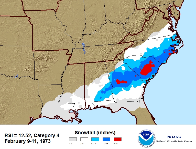 RSI map example for snowstorm events.
The Regional Snowfall Index (RSI) is an index of significant snowstorms that impact the eastern two thirds of the U.S. The RSI ranks snowstorm impacts on a scale from 1 to 5, similar to the Fujita scale for tornadoes or the Saffir-Simpson scale for hurricanes. NCEI has analyzed and assigned RSI values to over 500 storms going as far back as 1900. New storms are added operationally. As such, RSI puts the regional impacts of snowstorms into a century-scale historical perspective. The RSI differs from other indices because it includes population. RSI is based on the spatial extent of the storm, the amount of snowfall, and the juxtaposition of these elements with population. The area and population are cumulative values above regional specific thresholds. For example, the thresholds for the Southeast are 2", 5", 10", and 15" of snowfall while the thresholds for the Northeast are 4", 10", 20", and 30" of snowfall. Population information ties the index to societal impacts. Currently, the index uses population based on the 2000 Census. The RSI is an evolution of the Northeast Snowfall Impact Scale (NESIS) which NCDC (the precursor to NCEI) began producing operationally in 2005. While NESIS was developed for storms that had a major impact in the Northeast, it includes the impact of snow on other regions as well. It can be thought of as a quasi-national index that is calibrated to Northeast snowstorms. By contrast, the RSI is a regional index; a separate index is produced for each of the six NCDC climate regions in the eastern two-thirds of the nation. The indices are calculated in a similar fashion to NESIS, but our experience has led us to propose a change in the methodology. The new indices require region-specific parameters and thresholds for the calculations. For details on how RSI is calculated, see Squires et al. 2011.
Dataset Citation
- Cite as: Squires, Michael F.; Lawrimore, Jay H. (2011): Regional Snowfall Index [indicate subset used]. NOAA National Centers for Environmental Information. https://doi.org/10.25921/r2cd-th81 [indicate access date]
Dataset Identifiers
- doi:10.25921/r2cd-th81
- NCEI DSI 3289_01
- gov.noaa.ncdc:C00465
ISO 19115-2 Metadata
gov.noaa.ncdc:C00465
| Search Data |
|
| Download Data |
|
| Distribution Formats |
|
| Ordering Instructions | Contact NCEI for other distribution options and instructions. |
| Distributor |
NOAA National Centers for Environmental Information ncei.info@noaa.gov |
| Dataset Point of Contact | User Services and Engagement Branch DOC/NOAA/NESDIS/NCEI > National Centers for Environmental Information, NESDIS, NOAA, U.S. Department of Commerce +1 828-271-4800 ncei.orders@noaa.gov |
| Time Period | 1900-01-01 to Present |
| Spatial Bounding Box Coordinates |
West: -100.0
East: -65.0
South: 30.0
North: 50.0
|
| Spatial Coverage Map |
| General Documentation |
|
| Associated Resources |
|
| Publication Dates |
|
| Data Presentation Form | Digital table - digital representation of facts or figures systematically displayed, especially in columns |
| Dataset Progress Status | Ongoing - data is continually being updated |
| Data Update Frequency | As needed |
| Purpose | This snowstorm impact rating scale factors in population, snowfall amounts, and storm coverage, thereby quantifying the societal impacts of a snowstorm for all major snowstorms since 1900. The RSI is important because of the need to place snowstorms and their societal impacts into a historical perspective on a regional scale. The index is useful for the media, emergency managers, the public and others who wish to compare regional impacts between different snowstorms. |
| Dataset Citation |
|
| Cited Authors |
|
| Publishers |
|
| Theme keywords |
Global Change Master Directory (GCMD) Science Keywords
|
| Data Center keywords |
Global Change Master Directory (GCMD) Data Center Keywords
|
| Place keywords |
Global Change Master Directory (GCMD) Location Keywords
|
| Stratum keywords |
Global Change Master Directory (GCMD) Location Keywords
|
| Use Constraints |
|
| Access Constraints |
|
| Fees |
|
| Lineage information for: dataset | |
|---|---|
| Lineage Statement | RSI values are a function of the area affected by the snowstorm, the amount of snow, and the number of people living in the path of the storm. For a full description of how the Index was calculated, please view the documentation. |
| Processing Steps |
|
| Source Datasets |
|
| Lineage information for: repository | |
|---|---|
| Processing Steps |
|
| Acquisition Information (collection) | |
|---|---|
| Instrument |
|
| Platform |
|
Last Modified: 2023-06-23
For questions about the information on this page, please email: ncei.info@noaa.gov
For questions about the information on this page, please email: ncei.info@noaa.gov