U.S. 15 Minute Precipitation Data
- identificationInfo
- contentInfo
- contentInfo
- distributionInfo
- dataQualityInfo
- dataQualityInfo
- metadataMaintenance
- acquisitionInformation
(MI_Metadata)
fileIdentifier: gov.noaa.ncdc:C00505
language: eng; USA
characterSet: (MD_CharacterSetCode) utf8
hierarchyLevel: (MD_ScopeCode) dataset
contact: (CI_ResponsibleParty)
organisationName: NOAA National Centers for Environmental Information
contactInfo: (CI_Contact)
address: (CI_Address)
electronicMailAddress: ncei.info@noaa.gov
onlineResource: (CI_OnlineResource)
linkage: https://www.ncei.noaa.gov/contact
name: NCEI Contact Information
description: Information for contacts at NCEI.
function: (CI_OnLineFunctionCode) information
role: (CI_RoleCode) pointOfContact
dateStamp: 2023-06-23
metadataStandardName: ISO 19115-2 Geographic Information - Metadata - Part 2: Extensions for Imagery and Gridded Data
metadataStandardVersion: ISO 19115-2:2009(E)
return to top
identificationInfo: (MD_DataIdentification)
citation: (CI_Citation)
title: U.S. 15 Minute Precipitation Data
alternateTitle: Precipitation 15 Minute
date: (CI_Date)
date: (unknown)
dateType: (CI_DateTypeCode) publication
identifier: (MD_Identifier)
code: NCEI DSI 3260
identifier: (MD_Identifier)
code: gov.noaa.ncdc:C00505
citedResponsibleParty: (CI_ResponsibleParty)
organisationName: DOC/NOAA/NESDIS/NCEI > National Centers for Environmental Information, NESDIS, NOAA, U.S. Department of Commerce
role: (CI_RoleCode) publisher
citedResponsibleParty: (CI_ResponsibleParty)
organisationName: DOC/NOAA/NESDIS/NCDC > National Climatic Data Center, NESDIS, NOAA, U.S. Department of Commerce
positionName: User Engagement and Services Branch
contactInfo: (CI_Contact)
phone: (CI_Telephone)
voice: +1 (828) 271-4800
facsimile: +1 (828) 271-4876
address: (CI_Address)
deliveryPoint: 151 Patton Avenue
deliveryPoint: Veach-Baley Federal Building, Room 468
city: Asheville
administrativeArea: NC
postalCode: 28801-5001
country: USA
electronicMailAddress: ncei.orders@noaa.gov
hoursOfService: 8:00 - 6:00 Eastern
role: (CI_RoleCode) originator
citedResponsibleParty: (CI_ResponsibleParty)
organisationName: DOC/NOAA/NESDIS/NCDC > National Climatic Data Center, NESDIS, NOAA, U.S. Department of Commerce
positionName: User Engagement and Services Branch
contactInfo: (CI_Contact)
phone: (CI_Telephone)
voice: +1 (828) 271-4800
facsimile: +1 (828) 271-4876
address: (CI_Address)
deliveryPoint: 151 Patton Avenue
deliveryPoint: Veach-Baley Federal Building, Room 468
city: Asheville
administrativeArea: NC
postalCode: 28801-5001
country: USA
electronicMailAddress: ncei.orders@noaa.gov
hoursOfService: 8:00 - 6:00 Eastern
role: (CI_RoleCode) author
presentationForm: (CI_PresentationFormCode) tableDigital
abstract: U.S. 15 Minute Precipitation Data is digital data set DSI-3260, archived at the National Climatic Data Center (NCDC). This is precipitation data. The primary source of data for this file is approximately 2,000 mostly U.S. weather stations operated or managed by the U.S. National Weather Service. Stations are primary, secondary, or cooperative observer sites that have the capability to measure precipitation at 15 minute intervals. This dataset contains 15-minute precipitation data (reported 4 times per hour, if precip occurs) for U.S. stations along with selected non-U.S. stations in U.S. territories and associated nations. It includes major city locations and many small town locations. Daily total precipitation is also included as part of the data record. NCDC has in archive data from most states as far back as 1970 or 1971, and continuing to the present day. The major parameter is precipitation amounts at 15 minute intervals, when precipitation actually occurs.
purpose: This dataset contains historical 15-minute precipitation observations for selected U.S. stations. Data values are typically delayed six months or more.
status: (MD_ProgressCode) underDevelopment
pointOfContact: (CI_ResponsibleParty)
organisationName: NOAA National Centers for Environmental Information
positionName: Customer Engagement Branch
contactInfo: (CI_Contact)
phone: (CI_Telephone)
voice: 1-828-271-4800
facsimile: 1-828-271-4876
address: (CI_Address)
deliveryPoint: 151 Patton Avenue
deliveryPoint: Veach-Baley Federal Building, Room 468
city: Asheville
administrativeArea: NC
postalCode: 28801-5001
country: USA
electronicMailAddress: ncei.orders@noaa.gov
onlineResource: (CI_OnlineResource)
linkage: https://www.ncei.noaa.gov
protocol: HTTPS
applicationProfile: Web Browser
name: NOAA National Centers for Environmental Information (NCEI)
description: NCEI home page with information, data access and contact information.
function: (CI_OnLineFunctionCode) information
hoursOfService: 8:00 - 6:00 Eastern
role: (CI_RoleCode) pointOfContact
resourceMaintenance: (MD_MaintenanceInformation)
maintenanceAndUpdateFrequency: (MD_MaintenanceFrequencyCode) asNeeded
graphicOverview: (MD_BrowseGraphic)
fileName: https://www.ncei.noaa.gov/pub/data/metadata/images/C00505.png
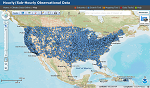
fileDescription: 15 Minute Precipitation Data GIS Image
fileType: PNG
descriptiveKeywords: (MD_Keywords)
keyword: Earth Science > Atmosphere > Altitude > Station Height
keyword: Earth Science > Atmosphere > Precipitation > Solid Precipitation > Snow
keyword: Earth Science > Atmosphere > Precipitation > Precipitation Amount
keyword: Earth Science > Atmosphere > Precipitation > Precipitation Rate
keyword: Earth Science > Atmosphere > Precipitation > Liquid Precipitation > Rain
type: (MD_KeywordTypeCode) theme
thesaurusName: (CI_Citation)
title: Global Change Master Directory (GCMD) Science Keywords
date: (CI_Date)
date: 2018
dateType: (CI_DateTypeCode) revision
edition: Version 8.6
citedResponsibleParty: (CI_ResponsibleParty)
organisationName: Global Change Data Center, Science and Exploration Directorate, Goddard Space Flight Center (GSFC) National Aeronautics and Space Administration (NASA)
contactInfo: (CI_Contact)
onlineResource: (CI_OnlineResource)
linkage: https://earthdata.nasa.gov/about/gcmd/global-change-master-directory-gcmd-keywords
protocol: HTTPS
applicationProfile: Web Browser
name: Global Change Master Directory (GCMD) Keywords
description: The information provided on this page seeks to define how the GCMD Keywords are structured, used and accessed. It also provides information on how users can participate in the further development of the keywords.
function: (CI_OnLineFunctionCode) information
role: (CI_RoleCode) publisher
descriptiveKeywords: (MD_Keywords)
keyword: Land Surface
type: (MD_KeywordTypeCode) product
thesaurusName: (CI_Citation)
title: Keyword Thesaurus Title
date: (missing)
descriptiveKeywords: (MD_Keywords)
keyword: Continent > North America > United States Of America
keyword: Ocean > Atlantic Ocean > North Atlantic Ocean > Caribbean Sea > Virgin Islands
keyword: Ocean > Pacific Ocean > Western Pacific Ocean > Micronesia > Guam
keyword: Ocean > Pacific Ocean > Central Pacific Ocean > American Samoa
keyword: Ocean > Pacific Ocean > Western Pacific Ocean > Micronesia > Marshall Islands
keyword: Ocean > Pacific Ocean > Western Pacific Ocean > Micronesia
keyword: Ocean > Pacific Ocean > Western Pacific Ocean > Micronesia > Palau
keyword: Ocean > Pacific Ocean > Central Pacific Ocean > Wake Island
type: (MD_KeywordTypeCode) place
thesaurusName: (CI_Citation)
title: Global Change Master Directory (GCMD) Location Keywords
date: (CI_Date)
date: 2018
dateType: (CI_DateTypeCode) revision
edition: Version 8.6
citedResponsibleParty: (CI_ResponsibleParty)
organisationName: Global Change Data Center, Science and Exploration Directorate, Goddard Space Flight Center (GSFC) National Aeronautics and Space Administration (NASA)
contactInfo: (CI_Contact)
onlineResource: (CI_OnlineResource)
linkage: https://earthdata.nasa.gov/about/gcmd/global-change-master-directory-gcmd-keywords
protocol: HTTPS
applicationProfile: Web Browser
name: Global Change Master Directory (GCMD) Keywords
description: The information provided on this page seeks to define how the GCMD Keywords are structured, used and accessed. It also provides information on how users can participate in the further development of the keywords.
function: (CI_OnLineFunctionCode) information
role: (CI_RoleCode) publisher
descriptiveKeywords: (MD_Keywords)
keyword: Vertical Location > Land Surface
type: (MD_KeywordTypeCode) stratum
thesaurusName: (CI_Citation)
title: Global Change Master Directory (GCMD) Location Keywords
date: (CI_Date)
date: 2018
dateType: (CI_DateTypeCode) revision
edition: Version 8.6
citedResponsibleParty: (CI_ResponsibleParty)
organisationName: Global Change Data Center, Science and Exploration Directorate, Goddard Space Flight Center (GSFC) National Aeronautics and Space Administration (NASA)
contactInfo: (CI_Contact)
onlineResource: (CI_OnlineResource)
linkage: https://earthdata.nasa.gov/about/gcmd/global-change-master-directory-gcmd-keywords
protocol: HTTPS
applicationProfile: Web Browser
name: Global Change Master Directory (GCMD) Keywords
description: The information provided on this page seeks to define how the GCMD Keywords are structured, used and accessed. It also provides information on how users can participate in the further development of the keywords.
function: (CI_OnLineFunctionCode) information
role: (CI_RoleCode) publisher
descriptiveKeywords: (MD_Keywords)
keyword: DOC/NOAA/NESDIS/NCEI > National Centers for Environmental Information, NESDIS, NOAA, U.S. Department of Commerce
keyword: DOC/NOAA/NESDIS/NCDC > National Climatic Data Center, NESDIS, NOAA, U.S. Department of Commerce
type: (MD_KeywordTypeCode) dataCentre
thesaurusName: (CI_Citation)
title: Global Change Master Directory (GCMD) Data Center Keywords
date: (CI_Date)
date: 2018
dateType: (CI_DateTypeCode) revision
edition: Version 8.6
citedResponsibleParty: (CI_ResponsibleParty)
organisationName: Global Change Data Center, Science and Exploration Directorate, Goddard Space Flight Center (GSFC) National Aeronautics and Space Administration (NASA)
contactInfo: (CI_Contact)
onlineResource: (CI_OnlineResource)
linkage: https://earthdata.nasa.gov/about/gcmd/global-change-master-directory-gcmd-keywords
protocol: HTTPS
applicationProfile: Web Browser
name: Global Change Master Directory (GCMD) Keywords
description: The information provided on this page seeks to define how the GCMD Keywords are structured, used and accessed. It also provides information on how users can participate in the further development of the keywords.
function: (CI_OnLineFunctionCode) information
role: (CI_RoleCode) publisher
resourceConstraints: (MD_LegalConstraints)
useConstraints: (MD_RestrictionCode) otherRestrictions
otherConstraints: Cite this dataset when used as a source.
resourceConstraints: (MD_LegalConstraints)
accessConstraints: (MD_RestrictionCode) otherRestrictions
otherConstraints: Distribution liability: NOAA and NCEI make no warranty, expressed or implied, regarding these data, nor does the fact of distribution constitute such a warranty. NOAA and NCEI cannot assume liability for any damages caused by any errors or omissions in these data. If appropriate, NCEI can only certify that the data it distributes are an authentic copy of the records that were accepted for inclusion in the NCEI archives.
resourceConstraints: (MD_LegalConstraints)
useConstraints: (MD_RestrictionCode) otherRestrictions
otherConstraints: Use liability: NOAA and NCEI cannot provide any warranty as to the accuracy, reliability, or completeness of furnished data. Users assume responsibility to determine the usability of these data. The user is responsible for the results of any application of this data for other than its intended purpose.
resourceConstraints: (MD_LegalConstraints)
useConstraints: (MD_RestrictionCode) otherRestrictions
otherConstraints: Use Constraints: These data are made freely available to the public and the scientific community in the belief that their wide dissemination will lead to greater understanding and new scientific insights. The availability of these data does not constitute publication of the data. NOAA relies on the ethics and integrity of the user to assure that NCDC receives fair credit for their work. If the data are obtained for potential use in a publication or presentation, NCDC should be informed at the outset of the nature of this work. If the NCDC data are essential to the work, or if an important result or conclusion depends on the NCDC data, co-authorship may be appropriate. This should be discussed at an early stage in the work. Manuscripts using the NCDC data should be sent to NCDC for review before they are submitted for publication so we can insure that the quality and limitations of the data are accurately represented.
language: eng; USA
topicCategory: (MD_TopicCategoryCode) climatologyMeteorologyAtmosphere
extent: (EX_Extent)
geographicElement: (EX_GeographicBoundingBox)
westBoundLongitude: 130.0
eastBoundLongitude: -60.0
southBoundLatitude: -15.0
northBoundLatitude: 72.0
temporalElement: (EX_TemporalExtent)
extent:
TimePeriod:
beginPosition: 1970-01-01
endPosition:
return to top
contentInfo: (MI_CoverageDescription)
attributeDescription:
RecordType: Dataset Documentation for 15-minute Precipitation: Documentation includes details on description, fortmat/record layout, tables, etc.
contentType: (unknown)
return to top
contentInfo: (MD_FeatureCatalogueDescription)
includedWithDataset: (missing)
featureCatalogueCitation: (CI_Citation)
title: Entity and Attribute Overview: ftp://ftp.ncdc.noaa.gov/pub/data/cdo/documentation/PRECIP_15_documentation.pdf
date: (inapplicable)
otherCitationDetails: Entity and Attribute Detail Citation: None
return to top
distributionInfo: (MD_Distribution)
distributor: (MD_Distributor)
distributorContact: (CI_ResponsibleParty)
organisationName: NOAA National Centers for Environmental Information
contactInfo: (CI_Contact)
address: (CI_Address)
electronicMailAddress: ncei.info@noaa.gov
onlineResource: (CI_OnlineResource)
linkage: https://www.ncei.noaa.gov/contact
name: NCEI Contact Information
description: Information for contacts at NCEI.
function: (CI_OnLineFunctionCode) information
role: (CI_RoleCode) distributor
distributionOrderProcess: (MD_StandardOrderProcess)
fees: In most cases, electronic downloads of the data are free. However, fees may apply for custom orders, data certifications, copies of analog materials, and data distribution on physical media.
orderingInstructions: Contact NCEI for other distribution options and instructions.
distributorFormat: (MD_Format)
name: CSV
version: (missing)
distributorFormat: (MD_Format)
name: TSV
version: (missing)
distributorFormat: (MD_Format)
name: fixed-length ASCII text
version: (missing)
distributorFormat: (MD_Format)
name: ArcGIS
version: (missing)
distributorFormat: (MD_Format)
name: KMZ
version: (missing)
distributorFormat: (MD_Format)
name: PDF
version: (missing)
distributorTransferOptions: (MD_DigitalTransferOptions)
onLine: (CI_OnlineResource)
linkage: https://www.ncei.noaa.gov/metadata/geoportal/rest/metadata/item/gov.noaa.ncdc:C00505/html
protocol: HTTPS
applicationProfile: Landing Page
name: NCEI Dataset Landing Page
description: Landing page for the dataset.
function: (CI_OnLineFunctionCode) information
distributorTransferOptions: (MD_DigitalTransferOptions)
onLine: (CI_OnlineResource)
linkage: https://www.ncdc.noaa.gov/cdo-web/search?datasetid=PRECIP_15
protocol: HTTPS
applicationProfile: Data Search Application
name: NCEI Climate Data Online Data Search
description: Search for the dataset via a text-based interface.
function: (CI_OnLineFunctionCode) search
distributorTransferOptions: (MD_DigitalTransferOptions)
onLine: (CI_OnlineResource)
linkage: https://www.ncei.noaa.gov/maps/hourly/?layers=01
protocol: HTTPS
applicationProfile: Map Search Application
name: NCEI Climate Data Online Map Server
description: Dynamic GIS mapping application to locate stations and data for selected layers.
function: (CI_OnLineFunctionCode) search
distributorTransferOptions: (MD_DigitalTransferOptions)
onLine: (CI_OnlineResource)
linkage: https://www.ncei.noaa.gov/pub/data/15min_precip-3260/
applicationProfile: Download
name: NCEI FTP Server
description: Dataset files available for download via FTP.
function: (CI_OnLineFunctionCode) download
distributorTransferOptions: (MD_DigitalTransferOptions)
onLine: (CI_OnlineResource)
linkage: https://gis.ncdc.noaa.gov/arcgis/rest/services/cdo/precip_15/MapServer
protocol: HTTPS
applicationProfile: REST
name: NCEI ArcGIS REST Services Directory
description: ArcGIS Server REST API for the dataset.
function: (CI_OnLineFunctionCode) search
distributorTransferOptions: (MD_DigitalTransferOptions)
onLine: (CI_OnlineResource)
linkage: https://gis.ncdc.noaa.gov/kml/precip_15.kmz
protocol: HTTPS
applicationProfile: KML
name: KMZ file for dataset
description: Direct download link for KMZ file.
function: (CI_OnLineFunctionCode) download
distributorTransferOptions: (MD_DigitalTransferOptions)
onLine: (CI_OnlineResource)
linkage: https://www.ncei.noaa.gov/pub/data/cdo/documentation/PRECIP_15_documentation.pdf
protocol: HTTPS
applicationProfile: Documentation
name: NCEI Dataset Documentation
description: Documentation of the dataset including a data description, format layout and definitions.
function: (CI_OnLineFunctionCode) download
distributorTransferOptions: (MD_DigitalTransferOptions)
onLine: (CI_OnlineResource)
linkage: https://www.ncei.noaa.gov/pub/data/cdo/samples/PRECIP_15_sample_csv.csv
protocol: HTTPS
applicationProfile: Sample
name: 15 Minute Precipitation CSV Sample
description: This sample data file shows how the data are formatted in CSV and is for example purposes only.
function: (CI_OnLineFunctionCode) download
distributorTransferOptions: (MD_DigitalTransferOptions)
onLine: (CI_OnlineResource)
linkage: https://www.ncei.noaa.gov/pub/data/cdo/samples/PRECIP_15_sample_ascii.dat
protocol: HTTPS
applicationProfile: Sample
name: 15 Minute Precipitation fixed-length ASCII Sample
description: This sample data file shows how the data are formatted in fixed-length ASCII text and is for example purposes only.
function: (CI_OnLineFunctionCode) download
return to top
dataQualityInfo: (DQ_DataQuality)
scope: (DQ_Scope)
level: (MD_ScopeCode) dataset
report: (DQ_CompletenessCommission)
evaluationMethodDescription: Completeness information not available.
result: (unknown)
report: (DQ_ConceptualConsistency)
measureDescription: Unknown
result: (unknown)
lineage: (LI_Lineage)
processStep: (LE_ProcessStep)
description: Not derived from another source.
dateTime: (unknown)
return to top
dataQualityInfo: (DQ_DataQuality)
scope: (DQ_Scope)
level: (MD_ScopeCode) repository
levelDescription: (MD_ScopeDescription)
other: NOAA National Centers for Environmental Information
lineage: (LI_Lineage)
processStep: (LE_ProcessStep)
description: NOAA created the National Centers for Environmental Information (NCEI) by merging NOAA's National Climatic Data Center (NCDC), National Geophysical Data Center (NGDC), and National Oceanographic Data Center (NODC), including the National Coastal Data Development Center (NCDDC), per the Consolidated and Further Continuing Appropriations Act, 2015, Public Law 113-235. NCEI launched publicly on April 22, 2015.
dateTime:
DateTime: 2015-04-22T00:00:00
return to top
metadataMaintenance: (MD_MaintenanceInformation)
maintenanceAndUpdateFrequency: (MD_MaintenanceFrequencyCode) asNeeded
maintenanceNote: Bulk metadata change applied on 2023-06-23. See version control repository history for metadata change details.
return to top
acquisitionInformation: (MI_AcquisitionInformation)
instrument: (MI_Instrument)
identifier: (MD_Identifier)
code: RAIN GAUGES
type: (missing)
platform: (MI_Platform)
identifier: (MD_Identifier)
code: METEOROLOGICAL STATIONS
description: (missing)
instrument: (missing)