Hurricane Irene Poster (August 27, 2011)
 NOAA produced Hurricane Irene poster
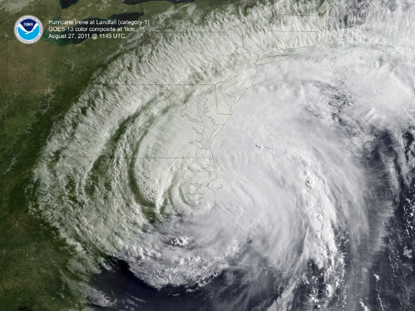
Hurricane Irene poster. Color composite GOES image shows Irene moving through the North Carolina Outer Banks on August 27, 2011. Poster size is 36"x27"
Cite this dataset when used as a source.
- POSTER-Irene
- gov.noaa.ncdc:C00696
| Download Data |
|
| Order Data |
|
| Distribution Formats |
- XML
- Printed Poster
- File Specification:
- File Compression:
- PDF
- File Specification:
- File Compression:
|
| Ordering Instructions |
Contact NCEI for other distribution options and instructions. |
| Distributor |
NOAA National Centers for Environmental Information
ncei.info@noaa.gov
|
| Dataset Point of Contact |
Axel Graumann
DOC/NOAA/NESDIS/NCEI > National Centers for Environmental Information, NESDIS, NOAA, U.S. Department of Commerce
+1 828-271-4800
ncei.orders@noaa.gov
|
| Coverage Description |
|
| Time Period |
2011-08-27 to 2011-08-27 |
| Spatial Bounding Box Coordinates |
West: -81.5
East: -71
South: 31
North: 43
|
| Spatial Coverage Map |
|
| Dataset Information |
|
| General Documentation |
|
| Publication Dates |
No administrative dates available |
| Data Presentation Form |
Digital image
Hardcopy image - image archived in analog format
|
| Dataset Progress Status |
Complete - production of the data has been completed |
| Data Update Frequency |
Not planned |
| Purpose |
To provide high quality posters for significant hurricane events for the public. |
| Use Limitations |
|
| Custodians |
- DOC/NOAA/NESDIS/NCDC > National Climatic Data Center, NESDIS, NOAA, U.S. Department of Commerce
- DOC/NOAA/NESDIS/NCDC > National Climatic Data Center, NESDIS, NOAA, U.S. Department of Commerce
|
| Publishers |
- DOC/NOAA/NESDIS/NCEI > National Centers for Environmental Information, NESDIS, NOAA, U.S. Department of Commerce
- DOC/NOAA/NESDIS/NCDC > National Climatic Data Center, NESDIS, NOAA, U.S. Department of Commerce
|
| Theme keywords |
Global Change Master Directory (GCMD) Science Keywords
- Earth Science > Atmosphere > Weather Events > Tropical Cyclones
- Earth Science > Human Dimensions > Natural Hazards > Tropical Cyclones > Hurricanes
- Earth Science > Atmosphere > Weather Events > Rain Storms
- Earth Science > Human Dimensions > Natural Hazards > Tropical Cyclones > Typhoons
- Earth Science > Atmosphere > Atmospheric Winds > Surface Winds
- Earth Science > Oceans > Ocean Winds > Surface Winds
- Earth Science Services > Data Analysis And Visualization > Visualization/Image Processing
|
| Data Center keywords |
Global Change Master Directory (GCMD) Data Center Keywords
- DOC/NOAA/NESDIS/NCDC > National Climatic Data Center, NESDIS, NOAA, U.S. Department of Commerce
- DOC/NOAA/NESDIS/NCEI > National Centers for Environmental Information, NESDIS, NOAA, U.S. Department of Commerce
|
| Platform keywords |
Global Change Master Directory (GCMD) Platform Keywords- Earth Observation Satellites > GOES (Geostationary Operational Environmental Satellite) > GOES > NOAA Geostationary Operational Environmental Satellites
|
| Place keywords |
Global Change Master Directory (GCMD) Location Keywords
- Continent > North America > United States Of America > South Carolina
- Continent > North America > United States Of America > North Carolina
- Continent > North America > United States Of America > Virginia
- Continent > North America > United States Of America > Delaware
- Continent > North America > United States Of America > Maryland
- Continent > North America > United States Of America > New Jersey
- Continent > North America > United States Of America > New York
- Continent > North America > United States Of America > Connecticut
- Continent > North America > United States Of America > District Of Columbia
- Continent > North America > United States Of America > Rhode Island
|
| Stratum keywords |
Global Change Master Directory (GCMD) Location Keywords
- Vertical Location > Land Surface
- Vertical Location > Sea Surface
|
| Use Constraints |
No constraint information available |
| Other Constraints |
None |
| Fees |
- In most cases, electronic downloads of the data are free. However, fees may apply for custom orders, data certifications, copies of analog materials, and data distribution on physical media.
|
| Lineage information for: dataset |
|---|
| Lineage Statement |
Multi-spectral hurricane image derived from data archived at NOAA. |
| Processing Environment |
paper forms |
| Lineage information for: repository |
|---|
| Processing Steps |
- 2015-04-22T00:00:00 - NOAA created the National Centers for Environmental Information (NCEI) by merging NOAA's National Climatic Data Center (NCDC), National Geophysical Data Center (NGDC), and National Oceanographic Data Center (NODC), including the National Coastal Data Development Center (NCDDC), per the Consolidated and Further Continuing Appropriations Act, 2015, Public Law 113-235. NCEI launched publicly on April 22, 2015.
|
Last Modified: 2023-06-23
For questions about the information on this page, please email:
ncei.info@noaa.gov