Dataset Overview | National Centers for Environmental Information (NCEI)

Merged Land and Ocean Surface Temperature, Version 3.5

MLOST v3.5; NOAA NCDC Global Surface Temperature v3.5

browse graphic
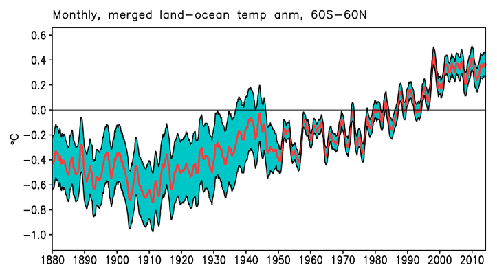
A monthly, merged land-ocean temperature anomaly graph from 60S-60N and 1880-2014.
The historical Merged Land-Ocean Surface Temperature Analysis (MLOST) is derived from two independent analyses, an Extended Reconstructed Sea Surface Temperature (ERSST) analysis and a land surface temperature (LST) analysis using the Global Historical Climatology Network (GHCN) temperature database. The data is merged into a compilation for monthly global surface temperature dating back from 1880 to the present, updated monthly, in gridded and timeseries formats. The changes from prior versions include improved tuning procedures, processing sea ice bias correction directly from ERSST, and the addition of satellite data. This data set is used in climate monitoring assessments of near-surface temperatures on a global scale.
  • Cite dataset when used as a source: Huang, B., T. Smith, J. Lawrimore, H.-M. Zhang, Merged Land-Ocean Surface Temperature, v3.5 [indicate subset used]. NOAA National Climatic Data Center. doi:10.7289/V5Q23X5V [access date].
gov.noaa.ncdc:C00759
Download Data
Distribution Formats
  • XML
  • fixed-length ASCII text
Ordering Instructions Contact NCEI for other distribution options and instructions.
Distributor NOAA National Centers for Environmental Information
ncei.info@noaa.gov
Dataset Point of Contact Boyin Huang
Physical Scientist
DOC/NOAA/NESDIS/NCEI > National Centers for Environmental Information, NESDIS, NOAA, U.S. Department of Commerce
+1 828-271-4800
boyin.huang@noaa.gov
Dataset Point of Contact Customer Engagement Branch
NOAA National Centers for Environmental Information
1-828-271-4800
ncei.orders@noaa.gov
Coverage Description Global Extent
Time Period 1880-01-01 to Present
Spatial Bounding Box Coordinates
West: -180
East: 180
South: -90
North: 90
Spatial Coverage Map
Dataset Information
General Documentation
Associated Resources
  • Improvements to NOAA's Historical Merged Land and Ocean Surface Temperature Analysis (1880 to 2006)
    • AMS Journal MLOST artical
      The AMS Journal of Climate website for the scientific paper describing NCEI's MLOST data set (May 2008).
  • NOAA's Merged Land and Ocean Surface Temperature Analysis (MLOST), version 3.5
    • AMS Journal MLOST artical
      The AMS Journal of Climate website for the scientific paper describing NOAA's Merged Land and Ocean Surface Temperature Analysis (MLOST), version 3.5.
Publication Dates
  • publication: 2011-03-24
Edition Version 3.5
Data Presentation Form Digital table - digital representation of facts or figures systematically displayed, especially in columns
Dataset Progress Status Ongoing - data is continually being updated
Data Update Frequency Monthly
Purpose For scientific research and assessment on global surface temperature climatology.
Use Limitations
  • For a complete description of use limiataions for this data set, see the associated documents.
Dataset Citation
  • Cite dataset when used as a source: Huang, B., T. Smith, J. Lawrimore, H.-M. Zhang, Merged Land-Ocean Surface Temperature, v3.5 [indicate subset used]. NOAA National Climatic Data Center. doi:10.7289/V5Q23X5V [access date].
Cited Authors
  • Boyin Huang
    DOC/NOAA/NESDIS/NCDC > National Climatic Data Center, NESDIS, NOAA, U.S. Department of Commerce
  • Thomas M. Smith
    DOC/NOAA/NESDIS/STAR > Center for Satellite Applications and Research, NESDIS, NOAA, U.S. Department of Commerce
  • Jay Lawrimore
    DOC/NOAA/NESDIS/NCDC > National Climatic Data Center, NESDIS, NOAA, U.S. Department of Commerce
  • Huiai.-Min. Zhang
    DOC/NOAA/NESDIS/NCDC > National Climatic Data Center, NESDIS, NOAA, U.S. Department of Commerce
  • Richard Reynolds
    DOC/NOAA/NESDIS/NCDC > National Climatic Data Center, NESDIS, NOAA, U.S. Department of Commerce
Originators
  • Thomas M. Smith
    DOC/NOAA/NESDIS/STAR > Center for Satellite Applications and Research, NESDIS, NOAA, U.S. Department of Commerce
Principal Investigators
  • Boyin Huang
    DOC/NOAA/NESDIS/NCDC > National Climatic Data Center, NESDIS, NOAA, U.S. Department of Commerce
Collaborators
  • Jay Lawrimore
    DOC/NOAA/NESDIS/NCDC > National Climatic Data Center, NESDIS, NOAA, U.S. Department of Commerce
  • Huiai.-Min. Zhang
    DOC/NOAA/NESDIS/NCDC > National Climatic Data Center, NESDIS, NOAA, U.S. Department of Commerce
  • Richard Reynolds
    DOC/NOAA/NESDIS/NCDC > National Climatic Data Center, NESDIS, NOAA, U.S. Department of Commerce
Publishers
  • DOC/NOAA/NESDIS/NCEI > National Centers for Environmental Information, NESDIS, NOAA, U.S. Department of Commerce
  • DOC/NOAA/NESDIS/NCDC > National Climatic Data Center, NESDIS, NOAA, U.S. Department of Commerce
Theme keywords Global Change Master Directory (GCMD) Science Keywords
  • Earth Science > Atmospheric > Atmospheric Temperature > Surface Air Temperature
  • Earth Science > Atmospheric > Atmospheric Temperature > Temperature Anomolies
  • Earth Science > Land Surface > Land Temperature
  • Earth Science > Oceans > Ocean Temperature > Sea Surface Temperature
Global Change Master Directory (GCMD) Science Keywords
  • Earth Science > In Situ Land-Based Platforms > Weather Stations/Networks > Meteorological Stations
  • Earth Science > In Situ Land-Based Platforms > Weather Stations/Networks > Weather Stations
  • Earth Science > In Situ Ocean-Based Platforms > Moorings
  • Earth Science > In Situ Ocean-Based Platforms > Buoys
Data Center keywords Global Change Master Directory (GCMD) Data Center Keywords
  • DOC/NOAA/NESDIS/NCDC > National Climatic Data Center, NESDIS, NOAA, U.S. Department of Commerce
  • DOC/NOAA/NESDIS/NCEI > National Centers for Environmental Information, NESDIS, NOAA, U.S. Department of Commerce
Instrument keywords Global Change Master Directory (GCMD) Instrument Keywords
  • Thermometers
Place keywords Global Change Master Directory (GCMD) Location Keywords
  • Geographic Region > Global
Stratum keywords Global Change Master Directory (GCMD) Location Keywords
  • Vertical Location > Land Surface
  • Vertical Location > Sea Surface
Use Constraints
  • Cite dataset when used as a source: Huang, B., T. Smith, J. Lawrimore, H.-M. Zhang, Merged Land-Ocean Surface Temperature, v3.5 [indicate subset used]. NOAA National Climatic Data Center. doi:10.7289/V5Q23X5V [access date].
  • Use liability: NOAA and NCEI cannot provide any warranty as to the accuracy, reliability, or completeness of furnished data. Users assume responsibility to determine the usability of these data. The user is responsible for the results of any application of this data for other than its intended purpose.
Access Constraints
  • Distribution liability: NOAA and NCEI make no warranty, expressed or implied, regarding these data, nor does the fact of distribution constitute such a warranty. NOAA and NCEI cannot assume liability for any damages caused by any errors or omissions in these data. If appropriate, NCEI can only certify that the data it distributes are an authentic copy of the records that were accepted for inclusion in the NCEI archives.
Fees
  • In most cases, electronic downloads of the data are free. However, fees may apply for custom orders, data certifications, copies of analog materials, and data distribution on physical media.
Lineage information for: dataset
Lineage Statement The Merged Land and Ocean Surface Temperature Analysis (MLOST) combines a global sea surface (water) temperature (SST) dataset with a global land surface air temperature dataset into this merged dataset of both the Earth land and ocean surface temperatures. The SST dataset is the Extended Reconstructed Sea Surface Temperature (ERSST) version 3b. The land surface air temperature dataset is similar to ERSST, but uses data from the Global Historical Climatology Network Monthly (GHCNM) database. The data were produced by and are archived at the NOAA National Centers for Environmental Information (NCEI).
Processor
  • DOC/NOAA/NESDIS/NCDC > National Climatic Data Center, NESDIS, NOAA, U.S. Department of Commerce
Processing Steps
  • Merged Land and Ocean Surface Temperature Analysis (MLOST) combines Extended Reconstructed Sea Surface Temperature (ERSST) version 3b and data from the Global Historical Climatology Network Monthly (GHCNM) database.
    Rationale:
Source Datasets
  • Extended Reconstructed Sea Surface Temperature (ERSST) version 3b
    • ERSST landing page
      This is the DOI landing page for the ERSST source data.
    • Description of Source: The sea surface temperature data was provided by the latest Extended Reconstructed Sea Surface Temperature (ERSST) verson 3b.
    • Temporal extent used: 1854-01-01 to Present
    • Spatial extent used: N:90.0 S:-90.0 E:180.0 W:-180.0
  • Global Historical Climatology Network (GHCN)
    • GHCN landing page
      This is the DOI landing page for the GHCN source data.
    • Description of Source: The sea surface temperature data was provided by the latest Extended Reconstructed Sea Surface Temperature (ERSST) verson 3b.
    • Temporal extent used: 1701-01-01 to Present
    • Spatial extent used: N:90.0 S:-90.0 E:180.0 W:-180.0
Lineage information for: repository
Processing Steps
  • 2015-04-22T00:00:00 - NOAA created the National Centers for Environmental Information (NCEI) by merging NOAA's National Climatic Data Center (NCDC), National Geophysical Data Center (NGDC), and National Oceanographic Data Center (NODC), including the National Coastal Data Development Center (NCDDC), per the Consolidated and Further Continuing Appropriations Act, 2015, Public Law 113-235. NCEI launched publicly on April 22, 2015.
Last Modified: 2023-06-23
For questions about the information on this page, please email: ncei.info@noaa.gov