African Easterly Wave Climatology, Version 1
(MI_Metadata)
fileIdentifier: gov.noaa.ncdc:C00784
language: eng; USA
characterSet: (MD_CharacterSetCode) utf8
hierarchyLevel: (MD_ScopeCode) dataset
contact: (CI_ResponsibleParty)
organisationName: NOAA National Centers for Environmental Information
contactInfo: (CI_Contact)
address: (CI_Address)
electronicMailAddress: ncei.info@noaa.gov
onlineResource: (CI_OnlineResource)
linkage: https://www.ncei.noaa.gov/contact
name: NCEI Contact Information
description: Information for contacts at NCEI.
function: (CI_OnLineFunctionCode) information
role: (CI_RoleCode) pointOfContact
dateStamp: 2023-06-23
metadataStandardName: ISO 19115-2 Geographic Information - Metadata - Part 2: Extensions for Imagery and Gridded Data
metadataStandardVersion: ISO 19115-2:2009(E)
return to top
identificationInfo: (MD_DataIdentification)
citation: (CI_Citation)
title: African Easterly Wave Climatology, Version 1
alternateTitle: AEWC
date: (CI_Date)
date: 2014-09-17
dateType: (CI_DateTypeCode) publication
edition: 1.0
identifier: (MD_Identifier)
code:
Anchor: DOI doi:10.7289/V5ZC80SX
identifier: (MD_Identifier)
code: NCEI DSI 6193_01
identifier: (MD_Identifier)
code: gov.noaa.ncdc:C00784
citedResponsibleParty: (CI_ResponsibleParty)
organisationName: DOC/NOAA/NESDIS/NCEI > National Centers for Environmental Information, NESDIS, NOAA, U.S. Department of Commerce
role: (CI_RoleCode) publisher
citedResponsibleParty: (CI_ResponsibleParty)
organisationName: DOC/NOAA/NESDIS/NCDC > National Climatic Data Center, NESDIS, NOAA, U.S. Department of Commerce
positionName: User Engagement and Services Branch
contactInfo: (CI_Contact)
phone: (CI_Telephone)
voice: 1-828-271-4800
facsimile: 1-828-271-4876
address: (CI_Address)
deliveryPoint: 151 Patton Avenue
deliveryPoint: Veach-Baley Federal Building, Room 468
city: Asheville
administrativeArea: NC
postalCode: 28801-5001
country: USA
electronicMailAddress: ncei.orders@noaa.gov
onlineResource: (CI_OnlineResource)
linkage: https://www.ncdc.noaa.gov
protocol: HTTPS
applicationProfile: Web Browser
name: NOAA National Centers for Environmental Information (NCEI)
description: NCEI home page with information, data access, and customer support contacts.
function: (CI_OnLineFunctionCode) information
hoursOfService: 8:00 - 6:00 Eastern
role: (CI_RoleCode) publisher
citedResponsibleParty: (CI_ResponsibleParty)
organisationName: GIT/EAS > School of Earth and Atmospheric Sciences, Georgia Institute of Technology
role: (CI_RoleCode) originator
citedResponsibleParty: (CI_ResponsibleParty)
organisationName: GIT/EAS > School of Earth and Atmospheric Sciences, Georgia Institute of Technology
role: (CI_RoleCode) author
citedResponsibleParty: (CI_ResponsibleParty)
individualName: Belanger, James I.
organisationName: GIT/EAS > School of Earth and Atmospheric Sciences, Georgia Institute of Technology
role: (CI_RoleCode) principalInvestigator
citedResponsibleParty: (CI_ResponsibleParty)
individualName: Belanger, James I.
organisationName: GIT/EAS > School of Earth and Atmospheric Sciences, Georgia Institute of Technology
role: (CI_RoleCode) author
citedResponsibleParty: (CI_ResponsibleParty)
individualName: Jelinek, Mark T.
organisationName: GIT/EAS > School of Earth and Atmospheric Sciences, Georgia Institute of Technology
role: (CI_RoleCode) principalInvestigator
citedResponsibleParty: (CI_ResponsibleParty)
individualName: Jelinek, Mark T.
organisationName: GIT/EAS > School of Earth and Atmospheric Sciences, Georgia Institute of Technology
role: (CI_RoleCode) author
citedResponsibleParty: (CI_ResponsibleParty)
individualName: Curry, Judith A.
organisationName: GIT/EAS > School of Earth and Atmospheric Sciences, Georgia Institute of Technology
role: (CI_RoleCode) principalInvestigator
citedResponsibleParty: (CI_ResponsibleParty)
individualName: Curry, Judith A.
organisationName: GIT/EAS > School of Earth and Atmospheric Sciences, Georgia Institute of Technology
role: (CI_RoleCode) author
presentationForm: (CI_PresentationFormCode) modelDigital
abstract: The AEWC dataset was created using a new algorithm developed by researchers at Georgia Tech and represents the first attempt to produce a standard easterly wave tracking dataset for the East Pacific, Atlantic, and Africa. The algorithm uses curvature vorticity anomalies to identify the location of easterly waves as a function of time. The dataset provides 6-hourly coverage over a 63-year period (January 1948-December 2010) in the region bounded by 35S-35N x 140W-40E. Data files are derived using four separate atmospheric reanalysis products including: 1) the ERA-40 dataset (covers the period January 1958 to December 2001); 2) the ERA-Interim dataset (covers the period January 1979 to December 2010); the CFS-R dataset (covers the period January 1979 to December 2010); and the NCEP/NCAR I dataset (covers the period January 1948 to December 2010). Other data sources used in the production of the AEWC are the Remote Sensing Systems SSM/I Total Precipitable Water, Rain Rate, and Cloud Liquid Water content products, Claus Brightness Temperature, and Outgoing Longwave Radiation from the NCDC Daily OLR CDR. Each netCDF file contains all the easterly waves that originate in a given year, the isobaric level for easterly wave tracking (600hPa, 700hPa, and 850hPa) and the zone from which the easterly wave began its development. Zones include: Africa (AFR), Central America (CAM), North Atlantic (NAL), Northeast Pacific (NEP), South Atlantic (SAL), South America (SAM), Southeast Pacific (SEP), and Other (OTH). For each easterly wave, the following variables are provided including: wave observation count, wave trajectory id, wave time, wave trough centroid latitude, wave trough centroid longitude, wave trough maximum latitude, mean longitude of wave trough maximum latitude, wave trough minimum latitude, mean longitude of wave trough minimum latitude, wavelength, mean wave trough relative vorticity, maximum wave trough relative vorticity, minimum wave trough relative vorticity, standard deviation wave trough relative vorticity,mean wave trough curvature vorticity, maximum wave trough curvature vorticity, minimum wave trough curvature vorticity, standard deviation wave trough curvature vorticity, mean wave trough shear vorticity, maximum wave trough shear vorticity, minimum wave trough shear vorticity, standard deviation wave trough shear vorticity, mean wave trough Claus brightness temperature, standard deviation wave trough Claus brightness temperature, wave trough Claus brightness temperature area fraction, mean wave trough total precipitable water, standard deviation wave trough total precipitable water, wave trough total precipitable water area fraction, mean wave trough rain rate, standard deviation wave trough rain rate, wave trough rain rate area fraction, mean wave trough cloud liquid water, standard deviation wave trough cloud liquid water, wave trough cloud liquid water area fraction, mean wave trough outgoing longwave radiation, standard deviation wave trough outgoing longwave radiation, wave trough outgoing longwave radiation area fraction, mean wave trough outgoing longwave radiation anomaly, standard deviation wave trough outgoing longwave radiation anomaly.
purpose: The data will primarily be utilized by atmospheric scientists specializing in tropical meteorology. This may include studies of easterly wave genesis, intensification, and decay as well as the relationship between tropical cyclones and easterly waves.
status: (MD_ProgressCode) completed
pointOfContact: (CI_ResponsibleParty)
individualName: James Belanger
organisationName: The Weather Company, an IBM business
positionName: Senior Meteorological Scientist
contactInfo: (CI_Contact)
address: (CI_Address)
electronicMailAddress: james.belanger@weather.com
role: (CI_RoleCode) pointOfContact
pointOfContact: (CI_ResponsibleParty)
individualName: Hilawe Semunegus
organisationName: DOC/NOAA/NESDIS/NCEI > National Centers for Environmental Information, NESDIS, NOAA, U.S. Department of Commerce
positionName: Research Scientist
role: (CI_RoleCode) pointOfContact
resourceMaintenance: (MD_MaintenanceInformation)
maintenanceAndUpdateFrequency: (MD_MaintenanceFrequencyCode) notPlanned
graphicOverview: (MD_BrowseGraphic)
fileName: https://www.ncei.noaa.gov/pub/data/metadata/images/C00784_aewc_graphic.png
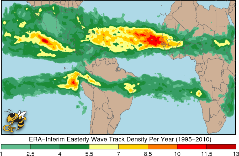
fileDescription: Easterly wave track density per year for the ERA-Interim reanalysis during the period June to November 1995-2010.
fileType: PNG
descriptiveKeywords: (MD_Keywords)
keyword: Earth Science > Climate Indicators > Atmospheric/Ocean Indicators > Extreme Weather
keyword: Earth Science > Climate Indicators > Atmospheric/Ocean Indicators > Teleconnections
type: (MD_KeywordTypeCode) theme
thesaurusName: (CI_Citation)
title: Global Change Master Directory (GCMD) Science Keywords
date: (CI_Date)
date: 2018
dateType: (CI_DateTypeCode) revision
edition: Version 8.6
citedResponsibleParty: (CI_ResponsibleParty)
organisationName: Global Change Data Center, Science and Exploration Directorate, Goddard Space Flight Center (GSFC) National Aeronautics and Space Administration (NASA)
contactInfo: (CI_Contact)
onlineResource: (CI_OnlineResource)
linkage: https://earthdata.nasa.gov/about/gcmd/global-change-master-directory-gcmd-keywords
protocol: HTTPS
applicationProfile: Web Browser
name: Global Change Master Directory (GCMD) Keywords
description: The information provided on this page seeks to define how the GCMD Keywords are structured, used and accessed. It also provides information on how users can participate in the further development of the keywords.
function: (CI_OnLineFunctionCode) information
role: (CI_RoleCode) publisher
descriptiveKeywords: (MD_Keywords)
keyword: Atmospheric - Upper-air - Upper-air Wind Speed And Direction
keyword: Atmospheric - Upper-air - Cloud Properties
type: (MD_KeywordTypeCode) theme
thesaurusName: (CI_Citation)
title: Global Climate Observing System (GCOS) Essential Climate Variables (ECVs)
date: (CI_Date)
date: 2017
dateType: (CI_DateTypeCode) publication
edition: Release 2017
citedResponsibleParty: (CI_ResponsibleParty)
organisationName: World Meteorological Organization, United Nations
contactInfo: (CI_Contact)
onlineResource: (CI_OnlineResource)
linkage: https://public.wmo.int/en/programmes/global-climate-observing-system/essential-climate-variables
protocol: HTTP
applicationProfile: Information
name: GCOS Essential Climate Variables
description: Overview of the GCOS Essential Climate Variables.
function: (CI_OnLineFunctionCode) information
role: (CI_RoleCode) custodian
descriptiveKeywords: (MD_Keywords)
keyword: Ocean > Atlantic Ocean
keyword: Ocean > Pacific Ocean
keyword: Continent > Africa
keyword: Continent > South America
keyword: Continent > North America > Central America
type: (MD_KeywordTypeCode) place
thesaurusName: (CI_Citation)
title: Global Change Master Directory (GCMD) Location Keywords
date: (CI_Date)
date: 2018
dateType: (CI_DateTypeCode) revision
edition: Version 8.6
citedResponsibleParty: (CI_ResponsibleParty)
organisationName: Global Change Data Center, Science and Exploration Directorate, Goddard Space Flight Center (GSFC) National Aeronautics and Space Administration (NASA)
contactInfo: (CI_Contact)
onlineResource: (CI_OnlineResource)
linkage: https://earthdata.nasa.gov/about/gcmd/global-change-master-directory-gcmd-keywords
protocol: HTTPS
applicationProfile: Web Browser
name: Global Change Master Directory (GCMD) Keywords
description: The information provided on this page seeks to define how the GCMD Keywords are structured, used and accessed. It also provides information on how users can participate in the further development of the keywords.
function: (CI_OnLineFunctionCode) information
role: (CI_RoleCode) publisher
descriptiveKeywords: (MD_Keywords)
keyword: Vertical Location > Troposphere
type: (MD_KeywordTypeCode) stratum
thesaurusName: (CI_Citation)
title: Global Change Master Directory (GCMD) Location Keywords
date: (CI_Date)
date: 2018
dateType: (CI_DateTypeCode) revision
edition: Version 8.6
citedResponsibleParty: (CI_ResponsibleParty)
organisationName: Global Change Data Center, Science and Exploration Directorate, Goddard Space Flight Center (GSFC) National Aeronautics and Space Administration (NASA)
contactInfo: (CI_Contact)
onlineResource: (CI_OnlineResource)
linkage: https://earthdata.nasa.gov/about/gcmd/global-change-master-directory-gcmd-keywords
protocol: HTTPS
applicationProfile: Web Browser
name: Global Change Master Directory (GCMD) Keywords
description: The information provided on this page seeks to define how the GCMD Keywords are structured, used and accessed. It also provides information on how users can participate in the further development of the keywords.
function: (CI_OnLineFunctionCode) information
role: (CI_RoleCode) publisher
descriptiveKeywords: (MD_Keywords)
keyword: SSMIS > Special Sensor Microwave Imager/Sounder
type: (MD_KeywordTypeCode) instrument
thesaurusName: (CI_Citation)
title: Global Change Master Directory (GCMD) Instrument Keywords
date: (CI_Date)
date: 2018
dateType: (CI_DateTypeCode) revision
edition: Version 8.6
citedResponsibleParty: (CI_ResponsibleParty)
organisationName: Global Change Data Center, Science and Exploration Directorate, Goddard Space Flight Center (GSFC) National Aeronautics and Space Administration (NASA)
contactInfo: (CI_Contact)
onlineResource: (CI_OnlineResource)
linkage: https://earthdata.nasa.gov/about/gcmd/global-change-master-directory-gcmd-keywords
protocol: HTTPS
applicationProfile: Web Browser
name: Global Change Master Directory (GCMD) Keywords
description: The information provided on this page seeks to define how the GCMD Keywords are structured, used and accessed. It also provides information on how users can participate in the further development of the keywords.
function: (CI_OnLineFunctionCode) information
role: (CI_RoleCode) publisher
descriptiveKeywords: (MD_Keywords)
keyword: GEOSTATIONARY SATELLITES
type: (MD_KeywordTypeCode) platform
thesaurusName: (CI_Citation)
title: Global Change Master Directory (GCMD) Platform Keywords
date: (CI_Date)
date: 2018
dateType: (CI_DateTypeCode) revision
edition: Version 8.6
citedResponsibleParty: (CI_ResponsibleParty)
organisationName: Global Change Data Center, Science and Exploration Directorate, Goddard Space Flight Center (GSFC) National Aeronautics and Space Administration (NASA)
contactInfo: (CI_Contact)
onlineResource: (CI_OnlineResource)
linkage: https://earthdata.nasa.gov/about/gcmd/global-change-master-directory-gcmd-keywords
protocol: HTTPS
applicationProfile: Web Browser
name: Global Change Master Directory (GCMD) Keywords
description: The information provided on this page seeks to define how the GCMD Keywords are structured, used and accessed. It also provides information on how users can participate in the further development of the keywords.
function: (CI_OnLineFunctionCode) information
role: (CI_RoleCode) publisher
descriptiveKeywords: (MD_Keywords)
keyword: 100 km - < 250 km or approximately 1 degree - < 2.5 degrees
type: (MD_KeywordTypeCode) dataResolution
thesaurusName: (CI_Citation)
title: Global Change Master Directory (GCMD) Horizontal Data Resolution Keywords
date: (CI_Date)
date: 2018
dateType: (CI_DateTypeCode) revision
edition: Version 8.6
citedResponsibleParty: (CI_ResponsibleParty)
organisationName: Global Change Data Center, Science and Exploration Directorate, Goddard Space Flight Center (GSFC) National Aeronautics and Space Administration (NASA)
contactInfo: (CI_Contact)
onlineResource: (CI_OnlineResource)
linkage: https://earthdata.nasa.gov/about/gcmd/global-change-master-directory-gcmd-keywords
protocol: HTTPS
applicationProfile: Web Browser
name: Global Change Master Directory (GCMD) Keywords
description: The information provided on this page seeks to define how the GCMD Keywords are structured, used and accessed. It also provides information on how users can participate in the further development of the keywords.
function: (CI_OnLineFunctionCode) information
role: (CI_RoleCode) publisher
descriptiveKeywords: (MD_Keywords)
keyword: > 1 km
type: (MD_KeywordTypeCode) dataResolution
thesaurusName: (CI_Citation)
title: Global Change Master Directory (GCMD) Vertical Data Resolution Keywords
date: (CI_Date)
date: 2018
dateType: (CI_DateTypeCode) revision
edition: Version 8.6
citedResponsibleParty: (CI_ResponsibleParty)
organisationName: Global Change Data Center, Science and Exploration Directorate, Goddard Space Flight Center (GSFC) National Aeronautics and Space Administration (NASA)
contactInfo: (CI_Contact)
onlineResource: (CI_OnlineResource)
linkage: https://earthdata.nasa.gov/about/gcmd/global-change-master-directory-gcmd-keywords
protocol: HTTPS
applicationProfile: Web Browser
name: Global Change Master Directory (GCMD) Keywords
description: The information provided on this page seeks to define how the GCMD Keywords are structured, used and accessed. It also provides information on how users can participate in the further development of the keywords.
function: (CI_OnLineFunctionCode) information
role: (CI_RoleCode) publisher
descriptiveKeywords: (MD_Keywords)
keyword: DOC/NOAA/NESDIS/NCDC > National Climatic Data Center, NESDIS, NOAA, U.S. Department of Commerce
keyword: DOC/NOAA/NESDIS/NCEI > National Centers for Environmental Information, NESDIS, NOAA, U.S. Department of Commerce
type: (MD_KeywordTypeCode) dataCentre
thesaurusName: (CI_Citation)
title: Global Change Master Directory (GCMD) Data Center Keywords
date: (CI_Date)
date: 2018
dateType: (CI_DateTypeCode) revision
edition: Version 8.6
citedResponsibleParty: (CI_ResponsibleParty)
organisationName: Global Change Data Center, Science and Exploration Directorate, Goddard Space Flight Center (GSFC) National Aeronautics and Space Administration (NASA)
contactInfo: (CI_Contact)
onlineResource: (CI_OnlineResource)
linkage: https://earthdata.nasa.gov/about/gcmd/global-change-master-directory-gcmd-keywords
protocol: HTTPS
applicationProfile: Web Browser
name: Global Change Master Directory (GCMD) Keywords
description: The information provided on this page seeks to define how the GCMD Keywords are structured, used and accessed. It also provides information on how users can participate in the further development of the keywords.
function: (CI_OnLineFunctionCode) information
role: (CI_RoleCode) publisher
resourceConstraints: (MD_LegalConstraints)
useConstraints: (MD_RestrictionCode) otherRestrictions
otherConstraints: Cite as: Belanger, James I., Jelinek, Mark T., Curry, Judith A. (2014): "African Easterly Wave Climatology, Version 1." NOAA National Centers for Environmental Information. [indicate subset used]. https://doi.org/10.7289/V5ZC80SX [access date].
resourceConstraints: (MD_LegalConstraints)
accessConstraints: (MD_RestrictionCode) otherRestrictions
otherConstraints: Distribution liability: NOAA and NCEI make no warranty, expressed or implied, regarding these data, nor does the fact of distribution constitute such a warranty. NOAA and NCEI cannot assume liability for any damages caused by any errors or omissions in these data. If appropriate, NCEI can only certify that the data it distributes are an authentic copy of the records that were accepted for inclusion in the NCEI archives.
resourceConstraints: (MD_LegalConstraints)
useConstraints: (MD_RestrictionCode) otherRestrictions
otherConstraints: Use liability: NOAA and NCEI cannot provide any warranty as to the accuracy, reliability, or completeness of furnished data. Users assume responsibility to determine the usability of these data. The user is responsible for the results of any application of this data for other than its intended purpose.
aggregationInfo: (MD_AggregateInformation)
aggregateDataSetName: (CI_Citation)
title: A climatology of easterly waves in the tropical Western Hemisphere
date: (missing)
citedResponsibleParty: (CI_ResponsibleParty)
organisationName: Geoscience Data Journal
role: (CI_RoleCode) publisher
citedResponsibleParty: (CI_ResponsibleParty)
organisationName: (missing)
contactInfo: (CI_Contact)
onlineResource: (CI_OnlineResource)
linkage: https://doi.org/10.1002/gdj3.40
protocol: HTTPS
applicationProfile: Web Browser
name: Belanger, J. I., Jelinek, M. T. and Curry, J. A. (2017), A climatology of easterly waves in the tropical Western Hemisphere. Geosci. Data J.. doi:10.1002/gdj3.40
description: Science paper associated with the dataset.
function: (CI_OnLineFunctionCode) information
role: (missing)
associationType: (DS_AssociationTypeCode) crossReference
initiativeType: (DS_InitiativeTypeCode) collection
spatialRepresentationType: (MD_SpatialRepresentationTypeCode) vector
spatialResolution: (MD_Resolution)
distance:
Distance: 222000
language: eng; USA
topicCategory: (MD_TopicCategoryCode) climatologyMeteorologyAtmosphere
environmentDescription: Data are processed using MATLAB R2012a 64-bit with access to NetCDF 4.1.3.
extent: (EX_Extent)
geographicElement: (EX_GeographicBoundingBox)
extentTypeCode: 1
westBoundLongitude: -140.0
eastBoundLongitude: 40.0
southBoundLatitude: -35.0
northBoundLatitude: 35.0
temporalElement: (EX_TemporalExtent)
extent:
TimePeriod:
description: ground condition
beginPosition: 1948
endPosition: 2010
timeInterval: 6
return to top
distributionInfo: (MD_Distribution)
distributor: (MD_Distributor)
distributorContact: (CI_ResponsibleParty)
organisationName: NOAA National Centers for Environmental Information
contactInfo: (CI_Contact)
address: (CI_Address)
electronicMailAddress: ncei.info@noaa.gov
onlineResource: (CI_OnlineResource)
linkage: https://www.ncei.noaa.gov/contact
name: NCEI Contact Information
description: Information for contacts at NCEI.
function: (CI_OnLineFunctionCode) information
role: (CI_RoleCode) distributor
distributionOrderProcess: (MD_StandardOrderProcess)
fees: In most cases, electronic downloads of the data are free. However, fees may apply for custom orders, data certifications, copies of analog materials, and data distribution on physical media.
orderingInstructions: Contact NCEI for other distribution options and instructions.
distributorFormat: (MD_Format)
name: XML
version: (missing)
distributorFormat: (MD_Format)
name: netCDF-4
version: (missing)
fileDecompressionTechnique: ZLIB compression
distributorTransferOptions: (MD_DigitalTransferOptions)
onLine: (CI_OnlineResource)
linkage: https://doi.org/10.7289/V5ZC80SX
protocol: HTTPS
applicationProfile: Landing Page
name: NCEI Dataset Landing Page
description: Landing page for the dataset.
function: (CI_OnLineFunctionCode) information
distributorTransferOptions: (MD_DigitalTransferOptions)
onLine: (CI_OnlineResource)
linkage: https://www.ncei.noaa.gov/data/african-easterly-wave-climatology/
protocol: HTTPS
applicationProfile: Download
name: NCEI Direct Download (Dataset Files)
description: Direct download for the dataset.
function: (CI_OnLineFunctionCode) download
return to top
dataQualityInfo: (DQ_DataQuality)
scope: (DQ_Scope)
level: (MD_ScopeCode) dataset
extent: #boundingExtent
lineage: (LI_Lineage)
statement: For more information about data creation, please review the associated documentation.
processStep: (LE_ProcessStep)
description: (missing)
dateTime: (missing)
processor: (CI_ResponsibleParty)
organisationName: (missing)
role: (CI_RoleCode) processor
source: sd001
source: sd002
source: sd003
source: sd004
source: sd005
source: sd006
source: sd007
processingInformation: (LE_Processing)
identifier: (missing)
documentation: (CI_Citation)
title: AEWC Documentation
date: (CI_Date)
date: 2014-09-09
dateType: (CI_DateTypeCode) publication
citedResponsibleParty: (CI_ResponsibleParty)
organisationName: DOC/NOAA/NESDIS/NCDC > National Climatic Data Center, NESDIS, NOAA, U.S. Department of Commerce
role: (CI_RoleCode) publisher
citedResponsibleParty: (CI_ResponsibleParty)
organisationName: (missing)
contactInfo: (CI_Contact)
onlineResource: (CI_OnlineResource)
linkage: https://www.ncei.noaa.gov/data/african-easterly-wave-climatology/doc/aewc_v1.0_doc_c20140904.pdf
applicationProfile: Web Browser
name: AEWC Documentation
description: More information about the AEWC dataset is available in the dataset documentation. Code documentation is also available for a more detailed description of processing steps. (See code tar file for more information)
function: (CI_OnLineFunctionCode) information
role: (missing)
source: (LE_Source)
description: Satellite data used in the production of the dataset
sourceCitation: (CI_Citation)
title: NOAA Climate Data Record (CDR) of Daily Outgoing Longwave Radiation (OLR), Version 1.2
date: (missing)
citedResponsibleParty: (CI_ResponsibleParty)
organisationName: DOC/NOAA/NESDIS/NCDC > National Climatic Data Center, NESDIS, NOAA, U.S. Department of Commerce
role: (CI_RoleCode) custodian
citedResponsibleParty: (CI_ResponsibleParty)
organisationName: (missing)
contactInfo: (CI_Contact)
onlineResource: (CI_OnlineResource)
linkage: https://www.ncei.noaa.gov/metadata/geoportal/rest/metadata/item/gov.noaa.ncdc:C00875/html
protocol: HTTPS
applicationProfile: Web Browser
name: NOAA Climate Data Record (CDR) of Daily Outgoing Longwave Radiation (OLR), Version 1.2
description: More information about the source dataset is available through the link
function: (CI_OnLineFunctionCode) information
role: (missing)
sourceExtent: (EX_Extent)
temporalElement: (EX_TemporalExtent)
extent:
TimePeriod:
beginPosition: 1979-01
endPosition: 2010-12
sourceStep: ps001
source: (LE_Source)
description: Reanalyses data used in the production of the dataset
sourceCitation: (CI_Citation)
title: NCEP/NCAR Reanalysis Data 1
date: (missing)
citedResponsibleParty: (CI_ResponsibleParty)
organisationName: DOC/NOAA/ESRL > Earth System Research Laboratory, NOAA, U.S. Department of Commerce
role: (CI_RoleCode) distributor
citedResponsibleParty: (CI_ResponsibleParty)
organisationName: (missing)
contactInfo: (CI_Contact)
onlineResource: (CI_OnlineResource)
linkage: http://www.esrl.noaa.gov/psd/data/gridded/data.ncep.reanalysis.html
applicationProfile: Web Browser
name: NCEP/NCAR Reanalysis Data 1
description: More information about the source dataset is available through the link
function: (CI_OnLineFunctionCode) information
role: (missing)
sourceExtent: (EX_Extent)
temporalElement: (EX_TemporalExtent)
extent:
TimePeriod:
beginPosition: 1948-01
endPosition: 2010-12
sourceStep: ps001
source: (LE_Source)
description: Reanalyses data used in the production of the dataset
sourceCitation: (CI_Citation)
title: Climate Forecast System Reanalysis (CFSR), for 1979 to 2011
date: (missing)
citedResponsibleParty: (CI_ResponsibleParty)
organisationName: DOC/NOAA/NESDIS/NCDC > National Climatic Data Center, NESDIS, NOAA, U.S. Department of Commerce
role: (CI_RoleCode) custodian
citedResponsibleParty: (CI_ResponsibleParty)
organisationName: (missing)
contactInfo: (CI_Contact)
onlineResource: (CI_OnlineResource)
linkage: https://www.ncei.noaa.gov/metadata/geoportal/rest/metadata/item/gov.noaa.ncdc:C00765/html
protocol: HTTPS
applicationProfile: Web Browser
name: Climate Forecast System Reanalysis (CFSR), for 1979 to 2011
description: More information about the source dataset is available through the link
function: (CI_OnLineFunctionCode) information
role: (missing)
sourceExtent: (EX_Extent)
temporalElement: (EX_TemporalExtent)
extent:
TimePeriod:
beginPosition: 1979-01
endPosition: 2010-12
sourceStep: ps001
source: (LE_Source)
description: Reanalyses data used in the production of the dataset
sourceCitation: (CI_Citation)
title: ERA-Interim
date: (missing)
citedResponsibleParty: (CI_ResponsibleParty)
organisationName: UCAR/NCAR/CISL/RDA > Research Data Archive, Computational and Information Systems Laboratory, National Center for Atmospheric Research, University Corporation for Atmospheric Research
role: (CI_RoleCode) distributor
citedResponsibleParty: (CI_ResponsibleParty)
organisationName: (missing)
contactInfo: (CI_Contact)
onlineResource: (CI_OnlineResource)
linkage: http://rda.ucar.edu/datasets/ds627.0/
applicationProfile: Web Browser
name: ERA-Interim
description: More information about the source dataset is available through the link
function: (CI_OnLineFunctionCode) information
role: (missing)
sourceExtent: (EX_Extent)
temporalElement: (EX_TemporalExtent)
extent:
TimePeriod:
beginPosition: 1979-01
endPosition: 2010-12
sourceStep: ps001
source: (LE_Source)
description: Reanalyses data used in the production of the dataset
sourceCitation: (CI_Citation)
title: ERA-40
date: (missing)
citedResponsibleParty: (CI_ResponsibleParty)
organisationName: ECMWF > European Centre for Medium-Range Weather Forecasts
role: (CI_RoleCode) distributor
citedResponsibleParty: (CI_ResponsibleParty)
organisationName: (missing)
contactInfo: (CI_Contact)
onlineResource: (CI_OnlineResource)
linkage: http://apps.ecmwf.int/datasets/data/era40_daily/
applicationProfile: Web Browser
name: ERA-40
description: More information about the source dataset is available through the link
function: (CI_OnLineFunctionCode) information
role: (missing)
sourceExtent: (EX_Extent)
temporalElement: (EX_TemporalExtent)
extent:
TimePeriod:
beginPosition: 1958-01
endPosition: 2001-12
sourceStep: ps001
source: (LE_Source)
description: Satellite data used in the production of the dataset
sourceCitation: (CI_Citation)
title: Claus Brightness Temperature
date: (missing)
citedResponsibleParty: (CI_ResponsibleParty)
organisationName: GB/NCAS/BADC > British Atmospheric Data Centre, NERC Centres for Atmospheric Science, United Kingdom
role: (CI_RoleCode) distributor
citedResponsibleParty: (CI_ResponsibleParty)
organisationName: (missing)
contactInfo: (CI_Contact)
onlineResource: (CI_OnlineResource)
linkage: https://badc.nerc.ac.uk/data/claus/claus.html
protocol: HTTPS
applicationProfile: Web Browser
name: Claus Brightness Temperature
description: More information about the source dataset is available through the link
function: (CI_OnLineFunctionCode) information
role: (missing)
sourceExtent: (EX_Extent)
temporalElement: (EX_TemporalExtent)
extent:
TimePeriod:
beginPosition: 1983-07
endPosition: 2006-06
sourceStep: ps001
source: (LE_Source)
description: Satellite data used in the production of the dataset
sourceCitation: (CI_Citation)
title: Remote Sensing Systems SSM/I
date: (missing)
citedResponsibleParty: (CI_ResponsibleParty)
organisationName: RSS > Remote Sensing Systems
role: (CI_RoleCode) distributor
citedResponsibleParty: (CI_ResponsibleParty)
organisationName: (missing)
contactInfo: (CI_Contact)
onlineResource: (CI_OnlineResource)
linkage: http://www.remss.com/missions/ssmi
applicationProfile: Web Browser
name: Remote Sensing Systems SSM/I
description: More information about the source dataset is available through the link
function: (CI_OnLineFunctionCode) information
role: (missing)
sourceExtent: (EX_Extent)
temporalElement: (EX_TemporalExtent)
extent:
TimePeriod:
beginPosition: 1987-07
endPosition: 2010-12
sourceStep: ps001
return to top
dataQualityInfo: (DQ_DataQuality)
scope: (DQ_Scope)
level: (MD_ScopeCode) repository
levelDescription: (MD_ScopeDescription)
other: NOAA National Centers for Environmental Information
lineage: (LI_Lineage)
processStep: (LE_ProcessStep)
description: NOAA created the National Centers for Environmental Information (NCEI) by merging NOAA's National Climatic Data Center (NCDC), National Geophysical Data Center (NGDC), and National Oceanographic Data Center (NODC), including the National Coastal Data Development Center (NCDDC), per the Consolidated and Further Continuing Appropriations Act, 2015, Public Law 113-235. NCEI launched publicly on April 22, 2015.
dateTime:
DateTime: 2015-04-22T00:00:00
return to top
metadataMaintenance: (MD_MaintenanceInformation)
maintenanceAndUpdateFrequency: (MD_MaintenanceFrequencyCode) asNeeded
maintenanceNote: Bulk metadata change applied on 2023-06-23. See version control repository history for metadata change details.