Logbooks from the English East India Company voyages digitized in keyed format from 1789 to 1834
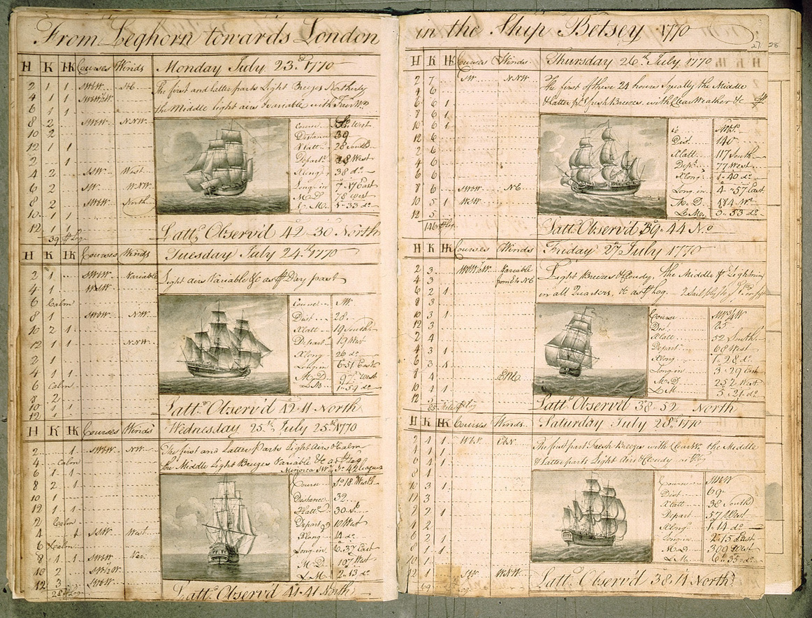 An image of a logbook from an EIC voyage with observations and pictures of the vessels.
This collection of keyed Logbooks from the East India Company voyages are formatted in a common digitized format. Data include daily instrumental measurements and weather observations from 1789 to 1834. Primary logbook elements (mainly daily data) include Latitude/Longitude (at noon), Ship's Course and Distance Traveled (at noon), Barometer (at noon), Air Temperature (at noon), Sea Surface Temperature (at noon), Sympiesometer (at noon), Wind Direction and Force (closest to noon), State of Weather/Visibility (all available), and State of Sea (all available). The physical logbooks originated from the India Office Records and Private Papers archived at the British Library. Approximately 893 EIC marine logbooks were keyed into digital formats by Climate Database Modernization Program (CDMP) from copies rescued and imaged by the British Library. The data will be organized by ship and labeled with an observational date range. These logbooks are a unique source of meteorological information for a period and an ocean area with historically sparse coverage. Images of 1,235 EIC logbooks from the British Library are archived at NCDC. Only a subset (893 logbooks) containing instrumental data were keyed into digital form by CDMP.
Cite this dataset when used as a source.
- NCEI DSI 9978_03
- gov.noaa.ncdc:C00785
| Order Data |
-
NCEI Customer Support (order)
NCEI provides customers with information and data from the NCEI archive. To order NCEI products and services contact the customer support team.
|
| Distribution Formats |
- ASCII
- File Compression: GNU zip compressed tar file
- CSV
- File Compression: No compression applied
- XML
|
| Ordering Instructions |
Contact NCEI for other distribution options and instructions. |
| Distributor |
NOAA National Centers for Environmental Information
ncei.info@noaa.gov
|
| Dataset Point of Contact |
Eric Freeman
Meteorologist
DOC/NOAA/NESDIS/NCEI > National Centers for Environmental Information, NESDIS, NOAA, U.S. Department of Commerce
828-271-4463
eric.freeman@noaa.gov
|
| Time Period |
1798-01-01 to 1834-06-01 |
| Spatial Bounding Box Coordinates |
West: -180.0
East: 180.0
South: -90.0
North: 90.0
|
| Spatial Coverage Map |
|
| General Documentation |
|
| Associated Resources |
- East India Company Logbooks
|
| Publication Dates |
|
| Data Presentation Form |
Digital table - digital representation of facts or figures systematically displayed, especially in columns
|
| Dataset Progress Status |
Complete - production of the data has been completed |
| Data Update Frequency |
As needed |
| Purpose |
These logbooks are a unique source of meteorological information for a period and an ocean area with historically sparse coverage that will contribute to climate studies. |
| Publishers |
- DOC/NOAA/NESDIS/NCEI > National Centers for Environmental Information, NESDIS, NOAA, U.S. Department of Commerce
- DOC/NOAA/NESDIS/NCDC > National Climatic Data Center, NESDIS, NOAA, U.S. Department of Commerce
|
| Theme keywords |
Global Change Master Directory (GCMD) Science Keywords
- Earth Science > Oceans > Ocean Winds > Surface Winds
- Earth Science > Atmosphere > Atmospheric Temperature > Surface Temperature
- Earth Science > Atmosphere > Atmospheric Pressure > Atmospheric Pressure Measurements
- Earth Science > Atmosphere > Atmospheric Phenomena
- Earth Science > Oceans > Ocean Waves > Sea State
- Earth Science > Oceans > Ocean Temperature > Sea Surface Temperature
|
| Data Center keywords |
Global Change Master Directory (GCMD) Data Center Keywords
- DOC/NOAA/NESDIS/NCDC > National Climatic Data Center, NESDIS, NOAA, U.S. Department of Commerce
- DOC/NOAA/NESDIS/NCEI > National Centers for Environmental Information, NESDIS, NOAA, U.S. Department of Commerce
|
| Platform keywords |
Global Change Master Directory (GCMD) Platform Keywords
|
| Instrument keywords |
Global Change Master Directory (GCMD) Instrument Keywords
- Thermometers
- Anemometers
- Rain Gauges
- Barometers
|
| Place keywords |
Global Change Master Directory (GCMD) Location Keywords- Geographic Region > Global Ocean
|
| Stratum keywords |
Global Change Master Directory (GCMD) Location Keywords- Vertical Location > Sea Surface
|
| Use Constraints |
- Use liability: NOAA and NCEI cannot provide any warranty as to the accuracy, reliability, or completeness of furnished data. Users assume responsibility to determine the usability of these data. The user is responsible for the results of any application of this data for other than its intended purpose.
|
| Access Constraints |
- Distribution liability: NOAA and NCEI make no warranty, expressed or implied, regarding these data, nor does the fact of distribution constitute such a warranty. NOAA and NCEI cannot assume liability for any damages caused by any errors or omissions in these data. If appropriate, NCEI can only certify that the data it distributes are an authentic copy of the records that were accepted for inclusion in the NCEI archives.
|
| Fees |
- In most cases, electronic downloads of the data are free. However, fees may apply for custom orders, data certifications, copies of analog materials, and data distribution on physical media.
|
| Lineage information for: dataset |
|---|
| Lineage Statement |
The Logbooks from East India Company voyages are digitized daily instrumental measurements and weather observations from 1789 to 1834. |
| Processing Steps |
- Data were keyed into digital tables for long term use and preservation. See documentation for more information.
- Data file naming pattern: _ = file name field delimiter; EICLOG = static field that identifies the East India Company Logbooks in Keyed Formats; L_MAR_B = field for the British Library Logbook Record ID and Part No. corresponding with the IDs in the data file names in the tar file; CDMP = for the raw keying format of the data from CDMP; S178901 = four-digit year and two-digit month of the earliest/starting observation in the data collection; E183406 = four-digit year and two-digit month of the latest/ending observation in the data collection; tar.gz = file format extension for the GNU zip compressed tar file
- Documentation file naming pattern: _ = file name field delimiter; EIC_VOYAGE_METADATA = static field that identifies the East India Company Logbooks metadata; v20110512 = version of document for date last modified; csv = file format extension for comma separated text values
|
| Source Datasets |
- East India Company Logbooks
-
Landing Page for East India Company Logbooks Images
For more information about the source images for the dataset, please follow the link.
- Description of Source: Data are keyed from East India Company Logbooks stored in the British Library in London.
- Temporal extent used: 1798 to 1834
|
| Lineage information for: repository |
|---|
| Processing Steps |
- 2015-04-22T00:00:00 - NOAA created the National Centers for Environmental Information (NCEI) by merging NOAA's National Climatic Data Center (NCDC), National Geophysical Data Center (NGDC), and National Oceanographic Data Center (NODC), including the National Coastal Data Development Center (NCDDC), per the Consolidated and Further Continuing Appropriations Act, 2015, Public Law 113-235. NCEI launched publicly on April 22, 2015.
|
| Acquisition Information (collection) |
|---|
| Instrument |
- > VISUAL OBSERVATIONS
- > THERMOMETERS
- > WIND VANES
- > BAROMETERS
- > SYPIESOMETERS
- > CHRONOMETERS
|
| Platform |
- SHIPS - East India Company (EIC) Voyages
|
| Operation |
- RECovery of Logbooks And International Marine data (RECLAIM) Project
|
Last Modified: 2023-06-23
For questions about the information on this page, please email:
ncei.info@noaa.gov