NOAA Climate Data Record (CDR) of MSU Level 1c Brightness Temperature, Version 1.0
MSU Brightness Temperature - NOAA
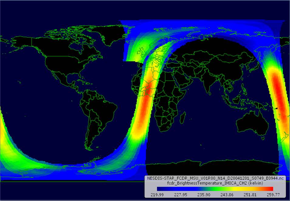 An orbit of MSU Level 1c brightness temperature data from NOAA-14.
This dataset contains Level 1c inter-calibrated brightness temperatures from the Microwave Sounding Unit (MSU) sensors onboard nine polar orbiting satellites (TIROS-N, NOAA-6, -7, -8, -9, -10, -11, -12, and -14) spanning from 1978 to 2006. The dataset was produced by the NOAA Center for Satellite Applications and Research (STAR), and is a Fundamental Climate Data Record (FCDR) of microwave brightness temperatures in the NOAA CDR Program. MSU is a four-channel microwave radiometer measuring at 50.3, 53.74, 54.96, and 57.95 GHz, and has ground spatial resolution of about 250 km in diameter at nadir. The native MSU Level 1b data were inter-calibrated using the Integrated Microwave Inter-Calibration Approach (IMICA) method to obtain a long-term data product to be used in climate analyses. For comparison, data files also include the operational data used in NWP forecasting along with the IMICA calibrated radiances, which minimize or remove the biases found in the operational calibration. In addition, limb adjusted radiances for both the IMICA and operational calibrations are included for certain type of climate applications, such as atmospheric layer temperature development using the radiance datasets. The orbital swath data files include MSU channels 2 through 4 for the IMICA calibration, and channels 1 through 4 for the operational calibration. The inter-calibrated MSU data are not expected to change for the dataset time period.
- Cite as: Zou, Cheng-Zhi; Wang, Wenhui; and NOAA CDR Program (2013): NOAA Fundamental Climate Data Record (FCDR) of MSU Level 1c Brightness Temperature, Version 1.0. [indicate subset used]. NOAA National Climatic Data Center. doi:10.7289/V51Z429F [access date].
| Search Data |
|
| Download Data |
|
| Distribution Formats |
- netCDF (Version: 4)
- File Specification: The NetCDF data files comply with the Climate and Forecast (CF) Metadata Conventions and the NetCDF Attribute Convention for Dataset Discovery (ACDD).
|
| Ordering Instructions |
Contact NCEI for other distribution options and instructions. |
| Distributor |
NOAA National Centers for Environmental Information
ncei.info@noaa.gov
|
| Dataset Point of Contact |
Customer Engagement Branch
NOAA National Centers for Environmental Information
1-828-271-4800
ncei.orders@noaa.gov
|
| Dataset Point of Contact |
NOAA Climate Data Record Program Office
DOC/NOAA/NESDIS/NCEI > National Centers for Environmental Information, NESDIS, NOAA, U.S. Department of Commerce
+1 (828) 271-4800
zou_msu_contacts@noaa.gov
|
| Coverage Description |
|
| Time Period |
1978-01-01 to 2006-12-31 (time interval: 2-hour) |
| Spatial Bounding Box Coordinates |
West: -180.0
East: 180.0
South: -90.0
North: 90.0
|
| Spatial Coverage Map |
|
| General Documentation |
|
| Processing Documents |
- Source Code Package for MSU Brightness Temperature - NOAA CDR
-
CDR Source Code (download)
This source code is for reference only. The source code is provided to maintain transparency of the algorithm and processes used in creating the Climate Data Record (CDR). The source code is not intended to be portable to any computer system(s) beyond that of the original CDR producer's environment.
- MSU FCDR Generation Flow Chart
- Climate Algorithm Theoretical Basis Document for MSU Radiance Fundamental Climate Data Record Derived from Integrated Microwave Inter-Calibration Approach
|
| Associated Resources |
- Data Stewardship Maturity Report for NOAA Climate Data Record (CDR) of MSU Level 1c Brightness Temperature (TB), Version 1.0
- Data Stewardship Maturity Report for NOAA Climate Data Record (CDR) of MSU Level 1c Brightness Temperature (TB), Version 1.0
- NOAA Fundamental Climate Data Record (FCDR) of AMSU-A Level 1c Brightness Temperature, Version 1.0
|
| Publication Dates |
|
| Edition |
Version 1.0 |
| Data Presentation Form |
Digital image
|
| Dataset Progress Status |
Complete - production of the data has been completed |
| Data Update Frequency |
Not planned |
| Purpose |
This dataset provides advanced scientific researchers a high quality Climate Data Record (CDR) of Upper Atmospheric Layer Temperatures--a high quality Fundamental Climate Data Record of microwave brightness temperature for use in long-term climate analyses. |
| Use Limitations |
- See the Algorithm Theoretical Basis Document for a description of the use limitations for this dataset.
|
| Dataset Citation |
- Cite as: Zou, Cheng-Zhi; Wang, Wenhui; and NOAA CDR Program (2013): NOAA Fundamental Climate Data Record (FCDR) of MSU Level 1c Brightness Temperature, Version 1.0. [indicate subset used]. NOAA National Climatic Data Center. doi:10.7289/V51Z429F [access date].
|
| Cited Authors |
- Zou, Cheng-Zhi
DOC/NOAA/NESDIS/STAR > Center for Satellite Applications and Research, NESDIS, NOAA, U.S. Department of Commerce
- Wang, Wenhui
DOC/NOAA/NESDIS/STAR > Center for Satellite Applications and Research, NESDIS, NOAA, U.S. Department of Commerce
- NOAA CDR Program
DOC/NOAA/NESDIS/NCDC > National Climatic Data Center, NESDIS, NOAA, U.S. Department of Commerce
|
| Principal Investigators |
- Zou, Cheng-Zhi
DOC/NOAA/NESDIS/STAR > Center for Satellite Applications and Research, NESDIS, NOAA, U.S. Department of Commerce
|
| Collaborators |
- Wang, Wenhui
DOC/NOAA/NESDIS/STAR > Center for Satellite Applications and Research, NESDIS, NOAA, U.S. Department of Commerce
- NOAA CDR Program
DOC/NOAA/NESDIS/NCDC > National Climatic Data Center, NESDIS, NOAA, U.S. Department of Commerce
|
| Publishers |
- NOAA National Centers for Environmental Information
- DOC/NOAA/NESDIS/NCDC > National Climatic Data Center, NESDIS, NOAA, U.S. Department of Commerce
|
| Theme keywords |
Global Change Master Directory (GCMD) Science Keywords- Earth Science > Spectral/Engineering > Microwave > Brightness Temperature
|
| Data Center keywords |
Global Change Master Directory (GCMD) Data Center Keywords
- DOC/NOAA/NESDIS/NCDC > National Climatic Data Center, NESDIS, NOAA, U.S. Department of Commerce
- DOC/NOAA/NESDIS/NCEI > National Centers for Environmental Information, NESDIS, NOAA, U.S. Department of Commerce
- DOC/NOAA/NESDIS/STAR > Center for Satellite Applications and Research, NESDIS, NOAA, U.S. Department of Commerce
|
| Platform keywords |
Global Change Master Directory (GCMD) Platform Keywords
- TIROS-N > Television Infrared Observation Satellite-N
- NOAA-6 > National Oceanic & Atmospheric Administration-6
- NOAA-7 > National Oceanic & Atmospheric Administration-7
- NOAA-8 > National Oceanic & Atmospheric Administration-8
- NOAA-9 > National Oceanic & Atmospheric Administration-9
- NOAA-10 > National Oceanic & Atmospheric Administration-10
- NOAA-11 > National Oceanic & Atmospheric Administration-11
- NOAA-12 > National Oceanic & Atmospheric Administration-12
- NOAA-14 > National Oceanic & Atmospheric Administration-14
|
| Instrument keywords |
Global Change Master Directory (GCMD) Instrument Keywords- MSU > Microwave Sounding Unit
|
| Place keywords |
Global Change Master Directory (GCMD) Location Keywords- Geographic Region > Global
|
| Project keywords |
Global Change Master Directory (GCMD) Project Keywords
- NOAA Climate Data Record (CDR) Program
- NOAA OneStop Project
|
| Data Resolution keywords |
Global Change Master Directory (GCMD) Vertical Data Resolution Keywords
Global Change Master Directory (GCMD) Temporal Data Resolution Keywords
Global Change Master Directory (GCMD) Horizontal Data Resolution Keywords- 50 km - < 100 km or approximately .5 degree - < 1 degree
|
| Use Constraints |
- Cite as: Zou, Cheng-Zhi; Wang, Wenhui; and NOAA CDR Program (2013): NOAA Fundamental Climate Data Record (FCDR) of MSU Level 1c Brightness Temperature, Version 1.0. [indicate subset used]. NOAA National Climatic Data Center. doi:10.7289/V51Z429F [access date].
- See the Use Agreement for this CDR available on the CDR page.
- Use liability: NOAA and NCEI cannot provide any warranty as to the accuracy, reliability, or completeness of furnished data. Users assume responsibility to determine the usability of these data. The user is responsible for the results of any application of this data for other than its intended purpose.
|
| Access Constraints |
- Distribution liability: NOAA and NCEI make no warranty, expressed or implied, regarding these data, nor does the fact of distribution constitute such a warranty. NOAA and NCEI cannot assume liability for any damages caused by any errors or omissions in these data. If appropriate, NCEI can only certify that the data it distributes are an authentic copy of the records that were accepted for inclusion in the NCEI archives.
|
| Fees |
- In most cases, electronic downloads of the data are free. However, fees may apply for custom orders, data certifications, copies of analog materials, and data distribution on physical media.
|
| Lineage information for: repository |
|---|
| Processing Steps |
- 2015-04-22T00:00:00 - NOAA created the National Centers for Environmental Information (NCEI) by merging NOAA's National Climatic Data Center (NCDC), National Geophysical Data Center (NGDC), and National Oceanographic Data Center (NODC), including the National Coastal Data Development Center (NCDDC), per the Consolidated and Further Continuing Appropriations Act, 2015, Public Law 113-235. NCEI launched publicly on April 22, 2015.
|
Last Modified: 2023-08-10
For questions about the information on this page, please email:
ncei.info@noaa.gov