SSMI(S) Hydrological Products
(MI_Metadata)
fileIdentifier: gov.noaa.ncdc:C00789
language: eng; USA
characterSet: (MD_CharacterSetCode) utf8
hierarchyLevel: (MD_ScopeCode) dataset
contact: (CI_ResponsibleParty)
organisationName: NOAA National Centers for Environmental Information
contactInfo: (CI_Contact)
address: (CI_Address)
electronicMailAddress: ncei.info@noaa.gov
onlineResource: (CI_OnlineResource)
linkage: https://www.ncei.noaa.gov/contact
name: NCEI Contact Information
description: Information for contacts at NCEI.
function: (CI_OnLineFunctionCode) information
role: (CI_RoleCode) pointOfContact
dateStamp: 2023-06-23
metadataStandardName: ISO 19115-2 Geographic Information - Metadata - Part 2: Extensions for Imagery and Gridded Data
metadataStandardVersion: ISO 19115-2:2009(E)
return to top
identificationInfo: (MD_DataIdentification)
citation: (CI_Citation)
title: SSMI(S) Hydrological Products
date: (CI_Date)
date: 2012-09-01
dateType: (CI_DateTypeCode) publication
date: (CI_Date)
date: 2017-11-01
dateType: (CI_DateTypeCode) revision
edition: Version 1
identifier: (MD_Identifier)
code:
Anchor: DOI doi:10.7289/V5QF8R3K
identifier: (MD_Identifier)
code: NCEI DSI 3652_01
identifier: (MD_Identifier)
code: gov.noaa.ncdc:C00789
citedResponsibleParty: (CI_ResponsibleParty)
organisationName: DOC/NOAA/NESDIS/NCEI > National Centers for Environmental Information, NESDIS, NOAA, U.S. Department of Commerce
role: (CI_RoleCode) publisher
citedResponsibleParty: (CI_ResponsibleParty)
individualName: Hilawe Semunegus
organisationName: DOC/NOAA/NESDIS/NCDC > National Climatic Data Center, NESDIS, NOAA, U.S. Department of Commerce
role: (CI_RoleCode) principalInvestigator
citedResponsibleParty: (CI_ResponsibleParty)
individualName: Hilawe Semunegus
organisationName: DOC/NOAA/NESDIS/NCDC > National Climatic Data Center, NESDIS, NOAA, U.S. Department of Commerce
role: (CI_RoleCode) author
citedResponsibleParty: (CI_ResponsibleParty)
individualName: Ralph Ferraro
organisationName: DOC/NOAA/NESDIS/STAR > Center for Satellite Applications and Research, NESDIS, NOAA, U.S. Department of Commerce
role: (CI_RoleCode) principalInvestigator
citedResponsibleParty: (CI_ResponsibleParty)
individualName: Ralph Ferraro
organisationName: DOC/NOAA/NESDIS/STAR > Center for Satellite Applications and Research, NESDIS, NOAA, U.S. Department of Commerce
role: (CI_RoleCode) author
presentationForm: (CI_PresentationFormCode) imageDigital
abstract: The Special Sensor Microwave/Imager (SSM/I) and Special Sensor Microwave Imager-Sounder (SSMIS) have been making measurements of earth-emitted microwave radiation for over two decades. Antenna temperature data from these sensors are used to derive both atmospheric and surface hydrological parameters and to generate these global monthly mean products. Specifically, this includes monthly or 5-day estimates of rainfall and its frequency, cloud liquid water and cloud frequency, water vapor, liquid water path, snow cover frequency, satellite sampling frequency and various imagery. The data collection consists of five different products: the Monthly 2.5 Degree Gridded Dataset, the Monthly 1.0 Degree Gridded Dataset, the Pentad 2.5 Degree Gridded Dataset, Imagery, and specially formatted files used in the Global Precipitation Climatology Project Dataset (GPCP). All data in this collection (except the Pentad and Imagery datasets) extend from July 1987 until present. Monthly 2.5 Degree Gridded Dataset Products included in this domain are taken from early orbits and include: mean cloud fraction (cfr), mean sea-ice cover (ice), liquid water path (lwp), mean rain fraction (pf2), rainfall (pr1), snow cover fraction (snw), mean sampling fraction (ssa), and mean total precipitable water (wvp). Products are averaged to 2.5 degree lat × 2.5 degree long grids. Imagery This dataset portrays monthly estimates of precipitable water (wvp), liquid water path (lwp), rainfall (pr1), and snow cover in both color and black and white. This domain of the SSM/I and SSMIS archive includes images of data from January 2006 to the present. GPCP Input files This time series domain of the SSM/I and SSMIS archive is formatted for the production of GPCP (Global Precipitation Climatology Project) datasets. The dataset is processed using early and late orbits plus a special "dual" orbit that combines the early and late satellite data. Products include rainfall (pr1 and pr2) and mean sampling fraction (ssa). The product is averaged to 2.5 degrees lat × 2.5 degrees long grids. Binary All data is also available in a legacy binary format, with the addition of a daily and pentad product. Products included in the daily domain are taken from early orbits and include: mean cloud fraction (cfr), mean sea-ice cover (ice), liquid water path (lwp), mean rain fraction (pf2), rainfall (pr1), snow cover fraction (snw), mean sampling fraction (ssa), and mean total precipitable water (wvp). Products are averaged to 1 lat x 1 long grids. Products included in Pentad domain are taken from specific satellite orbits and include: mean cloud fraction (cfr), mean sea-ice cover (ice), liquid water path (lwp), mean rain fraction (pf1 and pf2), rainfall (pr1 and pr2), snow cover fraction (snw), mean sampling fraction (ssa), and mean total precipitable water (wvp). Products are averaged to 2.5 lat x 2.5 long grids using 5-day estimates of rainfall and its frequency, cloud liquid water and cloud frequency, water vapor, liquid water path, snow cover frequency, satellite sampling frequency and various imagery. Pentad data only includes data from March 2008 to present. For a complete description of these products, please refer to all associated documentation.
purpose: This product is used to detect anomalies in precipitation patterns on a global scale. These products are useful for evaluating mean global precipitation, its interannual and seasonal variations, and the detection of anomalies associated with large-scale (e.g. ENSO, Arctic Oscillation) and regional climatic variations. Current users include members of the GPCP and the Climate Prediction Center, as well as various academic/government researchers nationally and internationally. It is a key input data source for the Global Precipitation Climatology Project (GPCP).
status: (MD_ProgressCode) onGoing
pointOfContact: (CI_ResponsibleParty)
organisationName: NOAA National Centers for Environmental Information
positionName: Customer Engagement Branch
contactInfo: (CI_Contact)
phone: (CI_Telephone)
voice: 1-828-271-4800
facsimile: 1-828-271-4876
address: (CI_Address)
deliveryPoint: 151 Patton Avenue
deliveryPoint: Veach-Baley Federal Building, Room 468
city: Asheville
administrativeArea: NC
postalCode: 28801-5001
country: USA
electronicMailAddress: ncei.orders@noaa.gov
onlineResource: (CI_OnlineResource)
linkage: https://www.ncei.noaa.gov
protocol: HTTPS
applicationProfile: Web Browser
name: NOAA National Centers for Environmental Information (NCEI)
description: NCEI home page with information, data access and contact information.
function: (CI_OnLineFunctionCode) information
hoursOfService: 8:00 - 6:00 Eastern
role: (CI_RoleCode) pointOfContact
resourceMaintenance: (MD_MaintenanceInformation)
maintenanceAndUpdateFrequency: (MD_MaintenanceFrequencyCode) monthly
graphicOverview: (MD_BrowseGraphic)
fileName: https://www.ncei.noaa.gov/pub/data/metadata/images/C00789_mw-hydro-2-5-grid.gif
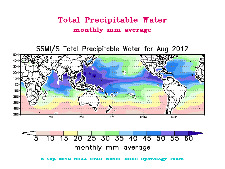
fileDescription: SSMI-SSMIS Hydrological Products image example
fileType: GIF
descriptiveKeywords: (MD_Keywords)
keyword: Earth Science > Cryosphere > Snow/Ice > Snow Cover
keyword: Earth Science > Cryosphere > Sea Ice > Ice Extent
keyword: Earth Science > Atmosphere > Clouds > Cloud Properties > Cloud Frequency
keyword: Earth Science > Atmosphere > Atmospheric Water Vapor
keyword: Earth Science > Atmosphere > Precipitation > Precipitation Rate
keyword: Earth Science > Atmosphere > Atmospheric Water Vapor > Water Vapor Indicators > Total Precipitable Water
type: (MD_KeywordTypeCode) theme
thesaurusName: (CI_Citation)
title: Global Change Master Directory (GCMD) Science Keywords
date: (CI_Date)
date: 2018
dateType: (CI_DateTypeCode) revision
edition: Version 8.6
citedResponsibleParty: (CI_ResponsibleParty)
organisationName: Global Change Data Center, Science and Exploration Directorate, Goddard Space Flight Center (GSFC) National Aeronautics and Space Administration (NASA)
contactInfo: (CI_Contact)
onlineResource: (CI_OnlineResource)
linkage: https://earthdata.nasa.gov/about/gcmd/global-change-master-directory-gcmd-keywords
protocol: HTTPS
applicationProfile: Web Browser
name: Global Change Master Directory (GCMD) Keywords
description: The information provided on this page seeks to define how the GCMD Keywords are structured, used and accessed. It also provides information on how users can participate in the further development of the keywords.
function: (CI_OnLineFunctionCode) information
role: (CI_RoleCode) publisher
descriptiveKeywords: (MD_Keywords)
keyword: Atmospheric - Surface - Precipitation
type: (MD_KeywordTypeCode) theme
thesaurusName: (CI_Citation)
title: Global Climate Observing System (GCOS) Essential Climate Variables (ECVs)
date: (CI_Date)
date: 2017
dateType: (CI_DateTypeCode) publication
edition: Release 2017
citedResponsibleParty: (CI_ResponsibleParty)
organisationName: World Meteorological Organization, United Nations
contactInfo: (CI_Contact)
onlineResource: (CI_OnlineResource)
linkage: https://public.wmo.int/en/programmes/global-climate-observing-system/essential-climate-variables
protocol: HTTP
applicationProfile: Information
name: GCOS Essential Climate Variables
description: Overview of the GCOS Essential Climate Variables.
function: (CI_OnLineFunctionCode) information
role: (CI_RoleCode) custodian
descriptiveKeywords: (MD_Keywords)
keyword: Geographic Region > Global
type: (MD_KeywordTypeCode) place
thesaurusName: (CI_Citation)
title: Global Change Master Directory (GCMD) Location Keywords
date: (CI_Date)
date: 2018
dateType: (CI_DateTypeCode) revision
edition: Version 8.6
citedResponsibleParty: (CI_ResponsibleParty)
organisationName: Global Change Data Center, Science and Exploration Directorate, Goddard Space Flight Center (GSFC) National Aeronautics and Space Administration (NASA)
contactInfo: (CI_Contact)
onlineResource: (CI_OnlineResource)
linkage: https://earthdata.nasa.gov/about/gcmd/global-change-master-directory-gcmd-keywords
protocol: HTTPS
applicationProfile: Web Browser
name: Global Change Master Directory (GCMD) Keywords
description: The information provided on this page seeks to define how the GCMD Keywords are structured, used and accessed. It also provides information on how users can participate in the further development of the keywords.
function: (CI_OnLineFunctionCode) information
role: (CI_RoleCode) publisher
descriptiveKeywords: (MD_Keywords)
keyword: Vertical Location > Land Surface
keyword: Vertical Location > Troposphere
type: (MD_KeywordTypeCode) stratum
thesaurusName: (CI_Citation)
title: Global Change Master Directory (GCMD) Location Keywords
date: (CI_Date)
date: 2018
dateType: (CI_DateTypeCode) revision
edition: Version 8.6
citedResponsibleParty: (CI_ResponsibleParty)
organisationName: Global Change Data Center, Science and Exploration Directorate, Goddard Space Flight Center (GSFC) National Aeronautics and Space Administration (NASA)
contactInfo: (CI_Contact)
onlineResource: (CI_OnlineResource)
linkage: https://earthdata.nasa.gov/about/gcmd/global-change-master-directory-gcmd-keywords
protocol: HTTPS
applicationProfile: Web Browser
name: Global Change Master Directory (GCMD) Keywords
description: The information provided on this page seeks to define how the GCMD Keywords are structured, used and accessed. It also provides information on how users can participate in the further development of the keywords.
function: (CI_OnLineFunctionCode) information
role: (CI_RoleCode) publisher
descriptiveKeywords: (MD_Keywords)
keyword: SSMIS > Special Sensor Microwave Imager/Sounder
keyword: SSMI > Special Sensor Microwave/Imager
type: (MD_KeywordTypeCode) instrument
thesaurusName: (CI_Citation)
title: Global Change Master Directory (GCMD) Instrument Keywords
date: (CI_Date)
date: 2018
dateType: (CI_DateTypeCode) revision
edition: Version 8.6
citedResponsibleParty: (CI_ResponsibleParty)
organisationName: Global Change Data Center, Science and Exploration Directorate, Goddard Space Flight Center (GSFC) National Aeronautics and Space Administration (NASA)
contactInfo: (CI_Contact)
onlineResource: (CI_OnlineResource)
linkage: https://earthdata.nasa.gov/about/gcmd/global-change-master-directory-gcmd-keywords
protocol: HTTPS
applicationProfile: Web Browser
name: Global Change Master Directory (GCMD) Keywords
description: The information provided on this page seeks to define how the GCMD Keywords are structured, used and accessed. It also provides information on how users can participate in the further development of the keywords.
function: (CI_OnLineFunctionCode) information
role: (CI_RoleCode) publisher
descriptiveKeywords: (MD_Keywords)
keyword: DMSP 5D-2/F8 > Defense Meteorological Satellite Program-F8
keyword: DMSP 5D-2/F10 > Defense Meteorological Satellite Program-F10
keyword: DMSP 5D-2/F11 > Defense Meteorological Satellite Program-F11
keyword: DMSP 5D-2/F13 > Defense Meteorological Satellite Program-F13
keyword: DMSP 5D-2/F14 > Defense Meteorological Satellite Program-F14
keyword: DMSP 5D-3/F15 > Defense Meteorological Satellite Program-F15
keyword: DMSP 5D-3/F16 > Defense Meteorological Satellite Program-F16
keyword: DMSP 5D-3/F17 > Defense Meteorological Satellite Program-F17
keyword: DMSP 5D-3/F18 > Defense Meteorological Satellite Program-F18
type: (MD_KeywordTypeCode) platform
thesaurusName: (CI_Citation)
title: Global Change Master Directory (GCMD) Platform Keywords
date: (CI_Date)
date: 2018
dateType: (CI_DateTypeCode) revision
edition: Version 8.6
citedResponsibleParty: (CI_ResponsibleParty)
organisationName: Global Change Data Center, Science and Exploration Directorate, Goddard Space Flight Center (GSFC) National Aeronautics and Space Administration (NASA)
contactInfo: (CI_Contact)
onlineResource: (CI_OnlineResource)
linkage: https://earthdata.nasa.gov/about/gcmd/global-change-master-directory-gcmd-keywords
protocol: HTTPS
applicationProfile: Web Browser
name: Global Change Master Directory (GCMD) Keywords
description: The information provided on this page seeks to define how the GCMD Keywords are structured, used and accessed. It also provides information on how users can participate in the further development of the keywords.
function: (CI_OnLineFunctionCode) information
role: (CI_RoleCode) publisher
descriptiveKeywords: (MD_Keywords)
keyword: Monthly Climatology
type: (MD_KeywordTypeCode) dataResolution
thesaurusName: (CI_Citation)
title: Global Change Master Directory (GCMD) Temporal Data Resolution Keywords
date: (CI_Date)
date: 2018
dateType: (CI_DateTypeCode) revision
edition: Version 8.6
citedResponsibleParty: (CI_ResponsibleParty)
organisationName: Global Change Data Center, Science and Exploration Directorate, Goddard Space Flight Center (GSFC) National Aeronautics and Space Administration (NASA)
contactInfo: (CI_Contact)
onlineResource: (CI_OnlineResource)
linkage: https://earthdata.nasa.gov/about/gcmd/global-change-master-directory-gcmd-keywords
protocol: HTTPS
applicationProfile: Web Browser
name: Global Change Master Directory (GCMD) Keywords
description: The information provided on this page seeks to define how the GCMD Keywords are structured, used and accessed. It also provides information on how users can participate in the further development of the keywords.
function: (CI_OnLineFunctionCode) information
role: (CI_RoleCode) publisher
descriptiveKeywords: (MD_Keywords)
keyword: 100 km - < 250 km or approximately 1 degree - < 2.5 degrees
type: (MD_KeywordTypeCode) dataResolution
thesaurusName: (CI_Citation)
title: Global Change Master Directory (GCMD) Horizontal Data Resolution Keywords
date: (CI_Date)
date: 2018
dateType: (CI_DateTypeCode) revision
edition: Version 8.6
citedResponsibleParty: (CI_ResponsibleParty)
organisationName: Global Change Data Center, Science and Exploration Directorate, Goddard Space Flight Center (GSFC) National Aeronautics and Space Administration (NASA)
contactInfo: (CI_Contact)
onlineResource: (CI_OnlineResource)
linkage: https://earthdata.nasa.gov/about/gcmd/global-change-master-directory-gcmd-keywords
protocol: HTTPS
applicationProfile: Web Browser
name: Global Change Master Directory (GCMD) Keywords
description: The information provided on this page seeks to define how the GCMD Keywords are structured, used and accessed. It also provides information on how users can participate in the further development of the keywords.
function: (CI_OnLineFunctionCode) information
role: (CI_RoleCode) publisher
descriptiveKeywords: (MD_Keywords)
keyword: DOC/NOAA/NESDIS/NCDC > National Climatic Data Center, NESDIS, NOAA, U.S. Department of Commerce
keyword: DOC/NOAA/NESDIS/NCEI > National Centers for Environmental Information, NESDIS, NOAA, U.S. Department of Commerce
type: (MD_KeywordTypeCode) dataCentre
thesaurusName: (CI_Citation)
title: Global Change Master Directory (GCMD) Data Center Keywords
date: (CI_Date)
date: 2018
dateType: (CI_DateTypeCode) revision
edition: Version 8.6
citedResponsibleParty: (CI_ResponsibleParty)
organisationName: Global Change Data Center, Science and Exploration Directorate, Goddard Space Flight Center (GSFC) National Aeronautics and Space Administration (NASA)
contactInfo: (CI_Contact)
onlineResource: (CI_OnlineResource)
linkage: https://earthdata.nasa.gov/about/gcmd/global-change-master-directory-gcmd-keywords
protocol: HTTPS
applicationProfile: Web Browser
name: Global Change Master Directory (GCMD) Keywords
description: The information provided on this page seeks to define how the GCMD Keywords are structured, used and accessed. It also provides information on how users can participate in the further development of the keywords.
function: (CI_OnLineFunctionCode) information
role: (CI_RoleCode) publisher
resourceConstraints: (MD_Constraints)
useLimitation: In October 2017, 2.5 degree and gpcp-input data files were identified as having the incorrect data date encoded in the netCDF. These files have been replaced in the archive. Users are encouraged to use data files with a create date later than October 18, 2017 to ensure they are using the best quality file.
resourceConstraints: (MD_LegalConstraints)
useConstraints: (MD_RestrictionCode) otherRestrictions
otherConstraints: Cite as: Semunegus, Hilawe; Ferraro, Ralph: (2012) SSMI(S) Hydrological Products [indicate subset used]. NOAA National Climatic Data Center. doi:10.7289/V5QF8R3K[indicate access date]
resourceConstraints: (MD_LegalConstraints)
useConstraints: (MD_RestrictionCode) otherRestrictions
otherConstraints: Please also cite the following science paper when using this dataset: Vila, D., C. Hernandez, R. Ferraro, and H. Semunegus, 2013: The Performance of Hydrological Monthly Products Using SSM/I-SSMI/S Sensors. J. Hydrometeor., 14, 266-274, https://doi.org/10.1175/JHM-D-12-056.1
resourceConstraints: (MD_LegalConstraints)
useConstraints: (MD_RestrictionCode) otherRestrictions
otherConstraints: Please also cite the following science paper when using this dataset: Ferraro, R.R., N.C. Grody, F. Weng, and A. Basist, 1996: An Eight-Year (1987-1994) Time Series of Rainfall, Clouds, Water Vapor, Snow Cover, and Sea Ice Derived from SSM/I Measurements. Bull. Amer. Meteor. Soc., 77, 891-905, https://doi.org/10.1175/1520-0477(1996)077<0891:AEYTSO>2.0.CO;2
resourceConstraints: (MD_LegalConstraints)
accessConstraints: (MD_RestrictionCode) otherRestrictions
otherConstraints: Distribution liability: NOAA and NCEI make no warranty, expressed or implied, regarding these data, nor does the fact of distribution constitute such a warranty. NOAA and NCEI cannot assume liability for any damages caused by any errors or omissions in these data. If appropriate, NCEI can only certify that the data it distributes are an authentic copy of the records that were accepted for inclusion in the NCEI archives.
resourceConstraints: (MD_LegalConstraints)
useConstraints: (MD_RestrictionCode) otherRestrictions
otherConstraints: Use liability: NOAA and NCEI cannot provide any warranty as to the accuracy, reliability, or completeness of furnished data. Users assume responsibility to determine the usability of these data. The user is responsible for the results of any application of this data for other than its intended purpose.
aggregationInfo: (MD_AggregateInformation)
aggregateDataSetName: (CI_Citation)
title: An Eight-Year (1987-1994) Time Series of Rainfall, Clouds, Water Vapor, Snow Cover, and Sea Ice Derived from SSM/I Measurements.
date: (CI_Date)
date: 1996-01-01
dateType: (CI_DateTypeCode) publication
identifier: (MD_Identifier)
code: Issue 77, pp. 891-905
citedResponsibleParty: (CI_ResponsibleParty)
organisationName: Bull. Amer. Meteor. Soc.
role: (CI_RoleCode) publisher
citedResponsibleParty: (CI_ResponsibleParty)
organisationName: (missing)
contactInfo: (CI_Contact)
onlineResource: (CI_OnlineResource)
linkage: https://doi.org/10.1175/1520-0477(1996)077%3C0891:AEYTSO%3E2.0.CO;2
applicationProfile: Web Browser
name: An Eight-Year (1987-1994) Time Series of Rainfall, Clouds, Water Vapor, Snow Cover, and Sea Ice Derived from SSM/I Measurements.
description: Published paper associated with dataset. DOI: http://dx.doi.org/10.1175/1520-0477(1996)077<0891:AEYTSO>>2.0.CO;2
function: (CI_OnLineFunctionCode) information
role: (missing)
associationType: (DS_AssociationTypeCode) largerWorkCitation
initiativeType: (DS_InitiativeTypeCode) collection
aggregationInfo: (MD_AggregateInformation)
aggregateDataSetName: (CI_Citation)
title: Improved Global Rainfall Retrieval Using the Special Sensor Microwave Imager (SSM/I).
date: (CI_Date)
date: 2010-01-01
dateType: (CI_DateTypeCode) publication
identifier: (MD_Identifier)
code: 49, 10321043; doi: http://dx.doi.org/10.1175/2009JAMC2294.1
citedResponsibleParty: (CI_ResponsibleParty)
organisationName: J. Appl. Meteor. Climatol.
role: (CI_RoleCode) publisher
citedResponsibleParty: (CI_ResponsibleParty)
organisationName: (missing)
contactInfo: (CI_Contact)
onlineResource: (CI_OnlineResource)
linkage: https://doi.org/10.1175/2009JAMC2294.1
applicationProfile: Web Browser
name: Improved Global Rainfall Retrieval Using the Special Sensor Microwave Imager (SSM/I).
description: Published paper associated with dataset. DOI: http://dx.doi.org/10.1175/2009JAMC2294.1
function: (CI_OnLineFunctionCode) information
role: (missing)
associationType: (DS_AssociationTypeCode) largerWorkCitation
initiativeType: (DS_InitiativeTypeCode) collection
aggregationInfo: (MD_AggregateInformation)
aggregateDataSetName: (CI_Citation)
title: The Performance of Hydrological Monthly Products Using SSM/I - SSMI/S Sensors
date: (CI_Date)
date: 2012-01-01
dateType: (CI_DateTypeCode) publication
identifier: (MD_Identifier)
code: 49, 10321043; doi: http://dx.doi.org/10.1175/JHM-D-12-056.1
citedResponsibleParty: (CI_ResponsibleParty)
organisationName: Journal of Hydrometeorology
role: (CI_RoleCode) publisher
citedResponsibleParty: (CI_ResponsibleParty)
organisationName: (missing)
contactInfo: (CI_Contact)
onlineResource: (CI_OnlineResource)
linkage: https://doi.org/10.1175/JHM-D-12-056.1
applicationProfile: Web Browser
name: The Performance of Hydrological Monthly Products Using SSM/I - SSMI/S Sensors
description: Published paper associated with dataset. DOI: http://dx.doi.org/10.1175/JHM-D-12-056.1
function: (CI_OnLineFunctionCode) information
role: (missing)
associationType: (DS_AssociationTypeCode) largerWorkCitation
initiativeType: (DS_InitiativeTypeCode) collection
aggregationInfo: (MD_AggregateInformation)
aggregateDataSetName: (CI_Citation)
title: GPCP Monthly V2.3
date: (CI_Date)
date: 2017-02-21
dateType: (CI_DateTypeCode) publication
identifier: (MD_Identifier)
code: DOI: 10.7289/V56971M6
citedResponsibleParty: (CI_ResponsibleParty)
organisationName: DOC/NOAA/NESDIS/NCEI > National Centers for Environmental Information, NESDIS, NOAA, U.S. Department of Commerce
role: (CI_RoleCode) publisher
citedResponsibleParty: (CI_ResponsibleParty)
organisationName: (missing)
contactInfo: (CI_Contact)
onlineResource: (CI_OnlineResource)
linkage: https://doi.org/10.7289/V56971M6
applicationProfile: Web Browser
name: GPCP Monthly V2.3
description: Related dataset.
function: (CI_OnLineFunctionCode) information
role: (missing)
associationType: (DS_AssociationTypeCode) largerWorkCitation
initiativeType: (DS_InitiativeTypeCode) collection
spatialRepresentationType: (MD_SpatialRepresentationTypeCode) grid
language: eng; USA
topicCategory: (MD_TopicCategoryCode) climatologyMeteorologyAtmosphere
extent: (EX_Extent)
geographicElement: (EX_GeographicBoundingBox)
extentTypeCode: 1
westBoundLongitude: -180.0
eastBoundLongitude: 180.0
southBoundLatitude: -90.0
northBoundLatitude: 90.0
temporalElement: (EX_TemporalExtent)
extent:
TimePeriod:
description: ground condition
beginPosition: 1987-07-01
endPosition:
timeInterval: 1
return to top
distributionInfo: (MD_Distribution)
distributor: (MD_Distributor)
distributorContact: (CI_ResponsibleParty)
organisationName: NOAA National Centers for Environmental Information
contactInfo: (CI_Contact)
address: (CI_Address)
electronicMailAddress: ncei.info@noaa.gov
onlineResource: (CI_OnlineResource)
linkage: https://www.ncei.noaa.gov/contact
name: NCEI Contact Information
description: Information for contacts at NCEI.
function: (CI_OnLineFunctionCode) information
role: (CI_RoleCode) distributor
distributionOrderProcess: (MD_StandardOrderProcess)
fees: In most cases, electronic downloads of the data are free. However, fees may apply for custom orders, data certifications, copies of analog materials, and data distribution on physical media.
orderingInstructions: Contact NCEI for other distribution options and instructions.
distributorFormat: (MD_Format)
name: netCDF
version: 4
specification: The NetCDF data files comply with the Climate and Forecast (CF) Metadata Conventions and the NetCDF Attribute Convention for Dataset Discovery (ACDD).
distributorFormat: (MD_Format)
name: Binary
version: (missing)
distributorTransferOptions: (MD_DigitalTransferOptions)
onLine: (CI_OnlineResource)
linkage: https://doi.org/10.7289/V5QF8R3K
protocol: HTTPS
applicationProfile: Landing Page
name: NCEI Dataset Landing Page
description: Landing page for the dataset.
function: (CI_OnLineFunctionCode) information
distributorTransferOptions: (MD_DigitalTransferOptions)
transferSize: (missing)
onLine: (CI_OnlineResource)
linkage: https://www.ncei.noaa.gov/data/ssmi-ssmis-hydrological-products/
protocol: HTTPS
applicationProfile: Download
name: NCEI Direct Download
description: Direct Download links for dataset files.
function: (CI_OnLineFunctionCode) download
return to top
dataQualityInfo: (DQ_DataQuality)
scope: (DQ_Scope)
level: (MD_ScopeCode) dataset
extent: #boundingExtent
lineage: (LI_Lineage)
statement: For more information about the production of this dataset, users should review the published science papers associated with the dataset.
processStep: (LE_ProcessStep)
description: NetCDF files are produced from the binary files.
dateTime: (missing)
processor: (CI_ResponsibleParty)
organisationName: (missing)
role: (CI_RoleCode) processor
source: sd001
processStep: (LE_ProcessStep)
description: In October 2017, 2.5 degree and gpcp-input data files were identified as having the incorrect data date encoded in the netCDF. These files have been replaced in the archive. Users are encouraged to use data files with a create date later than October 18, 2017, to ensure they are using the best quality file.
dateTime: (missing)
processor: (CI_ResponsibleParty)
organisationName: (missing)
role: (CI_RoleCode) processor
source: (LE_Source)
description: Defense Meteorological Satellite Program
sourceCitation: (CI_Citation)
title: CLASS Search Page for DMSP data
date: (missing)
citedResponsibleParty: (CI_ResponsibleParty)
organisationName: DOC/NOAA/CLASS > Comprehensive Large Array-data Stewardship System, NOAA, U.S. Department of Commerce
role: (CI_RoleCode) distributor
citedResponsibleParty: (CI_ResponsibleParty)
organisationName: (missing)
contactInfo: (CI_Contact)
onlineResource: (CI_OnlineResource)
linkage: https://www.class.noaa.gov/saa/products/search?datatype_family=DMSP
applicationProfile: Web Browser
name: CLASS Search Page for DMSP data
description: Search for SSMI/SSMIS data from the DMSP CLASS data family.
function: (CI_OnLineFunctionCode) information
role: (missing)
sourceExtent: (EX_Extent)
geographicElement: (EX_GeographicBoundingBox)
extentTypeCode: 1
westBoundLongitude: -180.0
eastBoundLongitude: 180.0
southBoundLatitude: -90.0
northBoundLatitude: 90.0
temporalElement: (EX_TemporalExtent)
extent:
TimePeriod:
beginPosition: 1987-07-01
endPosition:
sourceStep: ps001
return to top
dataQualityInfo: (DQ_DataQuality)
scope: (DQ_Scope)
level: (MD_ScopeCode) repository
levelDescription: (MD_ScopeDescription)
other: NOAA National Centers for Environmental Information
lineage: (LI_Lineage)
processStep: (LE_ProcessStep)
description: NOAA created the National Centers for Environmental Information (NCEI) by merging NOAA's National Climatic Data Center (NCDC), National Geophysical Data Center (NGDC), and National Oceanographic Data Center (NODC), including the National Coastal Data Development Center (NCDDC), per the Consolidated and Further Continuing Appropriations Act, 2015, Public Law 113-235. NCEI launched publicly on April 22, 2015.
dateTime:
DateTime: 2015-04-22T00:00:00
return to top
metadataMaintenance: (MD_MaintenanceInformation)
maintenanceAndUpdateFrequency: (MD_MaintenanceFrequencyCode) asNeeded
maintenanceNote: Bulk metadata change applied on 2023-06-23. See version control repository history for metadata change details.