Active Marine Station Metadata
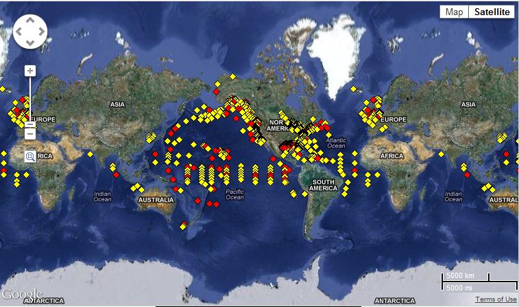 Global map of NDBC station coverage.
The Active Marine Station Metadata is a daily metadata report for active marine bouy and C-MAN (Coastal Marine Automated Network) platforms from the National Data Buoy Center (NDBC). Metadata includes the station id, latitude/longitude (resolution to thousandths of a degree), the station name, the station owner, the program the station is associated with (e.g., TAO, NDBC, tsunami, NOS, etc.), station type (e.g., buoy, fixed, oil rig, etc.), notification if the station observes meteorology, currents, and water quality (signified by 'y' for yes and 'n' for no). If there is a 'y' associated with one of these tags, then the station has reported data in that category within the last 8 hours (or 24 hours for DART stations--Deep-Ocean Assessment Reporting of Tsunamis). If there is an 'n', data has not been received within those times. Stations are removed from the list when they are dismantled. The metadata information is written to a daily XML-formatted file.
Dataset Citation
Cite this dataset when used as a source.
Dataset Identifiers
- NCEI DSI 1167_01
- gov.noaa.ncdc:C00819
ISO 19115-2 Metadata
gov.noaa.ncdc:C00819
| Order Data |
|
| Distribution Formats |
|
| Ordering Instructions | Contact NCEI for other distribution options and instructions. |
| Distributor |
NOAA National Centers for Environmental Information ncei.info@noaa.gov |
| Dataset Point of Contact | Customer Engagement Branch NOAA National Centers for Environmental Information 1-828-271-4800 ncei.orders@noaa.gov |
| Time Period | 2012-05-18 to Present |
| Spatial Bounding Box Coordinates |
West: -180.0
East: 180.0
South: -90.0
North: 90.0
|
| Spatial Coverage Map |
| Dataset Information |
|
| General Documentation |
|
| Publication Dates |
|
| Data Presentation Form | Digital table - digital representation of facts or figures systematically displayed, especially in columns |
| Dataset Progress Status | Under development - data is currently in the process of being created |
| Data Update Frequency | Daily |
| Purpose | NCDC uses this station information as the official list for populating C-MAN locations (capturing the latitude and longitude data) which are not transmitted with the original observations through the Global Telecommunications System (GTS). This metadata supplements existing ICOADS/GTS archived datasets and will also support ICOADS data processing at NCDC. |
| Cited Authors |
|
| Originators |
|
| Publishers |
|
| Theme keywords |
Global Change Master Directory (GCMD) Science Keywords
|
| Data Center keywords |
Global Change Master Directory (GCMD) Data Center Keywords
|
| Platform keywords |
Global Change Master Directory (GCMD) Platform Keywords
|
| Place keywords |
Global Change Master Directory (GCMD) Location Keywords
|
| Stratum keywords |
Global Change Master Directory (GCMD) Location Keywords
|
| Use Constraints |
|
| Access Constraints |
|
| Fees |
|
| Lineage information for: repository | |
|---|---|
| Processing Steps |
|
Last Modified: 2023-06-23
For questions about the information on this page, please email: ncei.info@noaa.gov
For questions about the information on this page, please email: ncei.info@noaa.gov