NOAA Climate Data Record (CDR) of Gridded Satellite Data from ISCCP B1 (GridSat-B1) Infrared Channel Brightness Temperature, Version 2
- identificationInfo
- contentInfo
- distributionInfo
- dataQualityInfo
- dataQualityInfo
- dataQualityInfo
- metadataMaintenance
(MI_Metadata)
fileIdentifier: gov.noaa.ncdc:C00829
language: eng; USA
characterSet: (MD_CharacterSetCode) utf8
hierarchyLevel: (MD_ScopeCode) dataset
contact: (CI_ResponsibleParty)
organisationName: NOAA National Centers for Environmental Information
contactInfo: (CI_Contact)
address: (CI_Address)
electronicMailAddress: ncei.info@noaa.gov
onlineResource: (CI_OnlineResource)
linkage: https://www.ncei.noaa.gov/contact
name: NCEI Contact Information
description: Information for contacts at NCEI.
function: (CI_OnLineFunctionCode) information
role: (CI_RoleCode) pointOfContact
dateStamp: 2023-08-10
metadataStandardName: ISO 19115-2 Geographic Information - Metadata - Part 2: Extensions for Imagery and Gridded Data
metadataStandardVersion: ISO 19115-2:2009(E)
return to top
identificationInfo: (MD_DataIdentification)
citation: (CI_Citation)
title: NOAA Climate Data Record (CDR) of Gridded Satellite Data from ISCCP B1 (GridSat-B1) Infrared Channel Brightness Temperature, Version 2
alternateTitle: Geostationary IR Channel Brightness Temperature - GridSat B1
date: (CI_Date)
date: 2014-02-26
dateType: (CI_DateTypeCode) publication
edition: v02r01
identifier: (MD_Identifier)
code:
Anchor: DOI doi:10.7289/V59P2ZKR
identifier: (MD_Identifier)
code: NCEI DSI 3648_02
identifier: (MD_Identifier)
code: gov.noaa.ncdc:C00829
citedResponsibleParty: (CI_ResponsibleParty)
organisationName: DOC/NOAA/NESDIS/NCEI > National Centers for Environmental Information, NESDIS, NOAA, U.S. Department of Commerce
role: (CI_RoleCode) publisher
citedResponsibleParty: (CI_ResponsibleParty)
individualName: Knapp, Kenneth R.
organisationName: DOC/NOAA/NESDIS/NCEI > National Centers for Environmental Information, NESDIS, NOAA, U.S. Department of Commerce
contactInfo: (CI_Contact)
onlineResource: (CI_OnlineResource)
linkage: http://www.webofscience.com/wos/author/record/E-9817-2011
applicationProfile: Web Browser
name: ResearcherID of dataset creator
description: ResearcherID is an identifier system that assigns codes for uniquely identifying scientific authors, other academic authors and contributors.
function: (CI_OnLineFunctionCode) information
role: (CI_RoleCode) principalInvestigator
citedResponsibleParty: (CI_ResponsibleParty)
individualName: Knapp, Kenneth R.
organisationName: DOC/NOAA/NESDIS/NCEI > National Centers for Environmental Information, NESDIS, NOAA, U.S. Department of Commerce
contactInfo: (CI_Contact)
onlineResource: (CI_OnlineResource)
linkage: http://www.webofscience.com/wos/author/record/E-9817-2011
applicationProfile: Web Browser
name: ResearcherID of dataset creator
description: ResearcherID is an identifier system that assigns codes for uniquely identifying scientific authors, other academic authors and contributors.
function: (CI_OnLineFunctionCode) information
role: (CI_RoleCode) author
citedResponsibleParty: (CI_ResponsibleParty)
organisationName: NOAA CDR Program
role: (CI_RoleCode) collaborator
citedResponsibleParty: (CI_ResponsibleParty)
organisationName: NOAA CDR Program
role: (CI_RoleCode) author
presentationForm: (CI_PresentationFormCode) imageDigital
abstract: The Gridded Satellite (GridSat-B1) data provides a uniform set of quality controlled geostationary satellite observations for the visible, infrared window and infrared water vapor channels. GridSat-B1 uses the International Satellite Cloud Climatology Project (ISCCP) B1 dataset providing coverage every 3 hours from 1980 to the present, and is updated quarterly as possible. The ISCCP B1 data have been quality controlled, calibrated, remapped and merged together to provide a nearly global coverage of top of the atmosphere radiances. Long-term temporal normalization is performed via calibration against HIRS channel 12 data during the period of record. The IR window channel data has received more extensive inter-satellite calibration and is thus identified as a Climate Data Record (CDR) by the NOAA CDR Program. GridSat-B1 data are projected on an equal angle grid, which facilitates the mapping and subsetting of the data. Since the ISCCP B1 native resolution is approximately 8km, the resolution of the equal area grid is 0.07 degrees latitude (approximately 8km at the Equator). The data span the globe in longitude and range from 70 degrees South to 70 degrees North latitude. GridSat version 2 differs from version 1 in the following ways: a) three channels are provided instead of just one, b) more quality control on the calibration, navigation and flagging of bad data, and c) extension of the period of record. Data are stored using netCDF-4 file format following the Climate and Forecast (CF) Conventions and the Attribute Convention for Dataset Discovery (ACDD) which facilitates usage with compatible software applications. Documentation and source code are available for the dataset.
purpose: This dataset provides scientific researchers a high quality Climate Data Record (CDR) of global infrared and visible measurements from geostationary satellites. These data can be applied to studies of tropical cyclones, the Intertropical Convergence Zone (ITCZ), global and regional precipitation monitoring, diurnal variation and outgoing longwave radiation. The data are intended to facilitate use of Global infrared measurements from geostationary satellites by non-satellite experts and to help facilitate large-scale processing via tools designed to process CF-compliant netCDF files.
status: (MD_ProgressCode) onGoing
pointOfContact: (CI_ResponsibleParty)
organisationName: DOC/NOAA/NESDIS/NCEI > National Centers for Environmental Information, NESDIS, NOAA, U.S. Department of Commerce
positionName: NOAA Climate Data Record Program Office
contactInfo: (CI_Contact)
phone: (CI_Telephone)
voice: +1 (828) 271-4800
facsimile: +1 (828) 271-4328
address: (CI_Address)
deliveryPoint: 151 Patton Avenue
deliveryPoint: Veach-Baley Federal Building, Room 447
city: Asheville
administrativeArea: NC
postalCode: 28801-5001
country: USA
electronicMailAddress: gridsat_b1_contacts@noaa.gov
onlineResource: (CI_OnlineResource)
linkage: https://www.ncei.noaa.gov/products/climate-data-records
protocol: HTTPS
applicationProfile: Web Browser
name: CDR Program Contacts
description: Contact information for the CDR Program.
function: (CI_OnLineFunctionCode) information
hoursOfService: 8:00 - 6:00 Eastern
role: (CI_RoleCode) pointOfContact
resourceMaintenance: (MD_MaintenanceInformation)
maintenanceAndUpdateFrequency: (MD_MaintenanceFrequencyCode) quarterly
graphicOverview: (MD_BrowseGraphic)
fileName: https://www.ncei.noaa.gov/pub/data/metadata/images/C00829_gridsat-b1.png
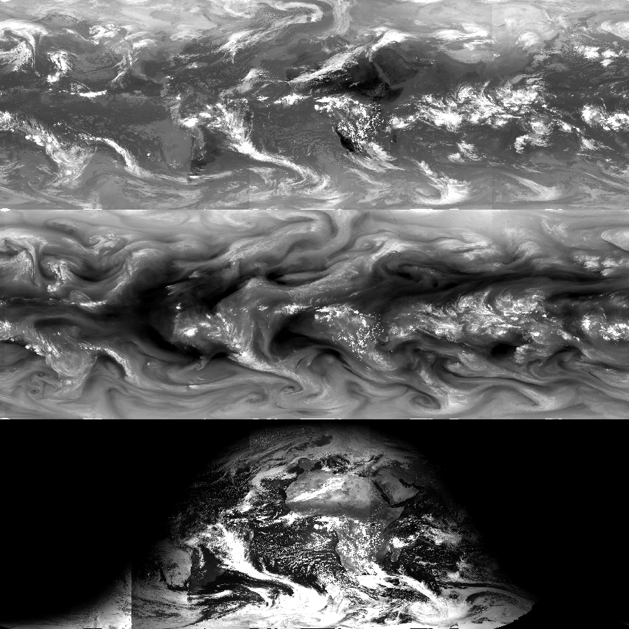
fileDescription: Image of IR window, water vapor and visible data.
fileType: PNG
descriptiveKeywords: (MD_Keywords)
keyword: Earth Science > Spectral/Engineering > Infrared Wavelengths > Brightness Temperature
keyword: Earth Science > Atmosphere > Atmospheric Radiation > Longwave Radiation
keyword: Earth Science > Atmosphere > Atmospheric Radiation > Reflectance
keyword: Earth Science > Atmosphere > Atmospheric Water Vapor > Water Vapor Indicators > Water Vapor
type: (MD_KeywordTypeCode) theme
thesaurusName: (CI_Citation)
title: Global Change Master Directory (GCMD) Science Keywords
date: (CI_Date)
date: 2018
dateType: (CI_DateTypeCode) revision
edition: Version 8.6
citedResponsibleParty: (CI_ResponsibleParty)
organisationName: Global Change Data Center, Science and Exploration Directorate, Goddard Space Flight Center (GSFC) National Aeronautics and Space Administration (NASA)
contactInfo: (CI_Contact)
onlineResource: (CI_OnlineResource)
linkage: https://earthdata.nasa.gov/about/gcmd/global-change-master-directory-gcmd-keywords
protocol: HTTPS
applicationProfile: Web Browser
name: Global Change Master Directory (GCMD) Keywords
description: The information provided on this page seeks to define how the GCMD Keywords are structured, used and accessed. It also provides information on how users can participate in the further development of the keywords.
function: (CI_OnLineFunctionCode) information
role: (CI_RoleCode) publisher
descriptiveKeywords: (MD_Keywords)
keyword: Atmospheric - Upper-air - Upper-air Water Vapour
keyword: Atmospheric - Upper-air - Earth Radiation Budget
type: (MD_KeywordTypeCode) theme
thesaurusName: (CI_Citation)
title: Global Climate Observing System (GCOS) Essential Climate Variables (ECVs)
date: (CI_Date)
date: 2017
dateType: (CI_DateTypeCode) publication
edition: Release 2017
citedResponsibleParty: (CI_ResponsibleParty)
organisationName: World Meteorological Organization, United Nations
contactInfo: (CI_Contact)
onlineResource: (CI_OnlineResource)
linkage: https://public.wmo.int/en/programmes/global-climate-observing-system/essential-climate-variables
protocol: HTTP
applicationProfile: Information
name: GCOS Essential Climate Variables
description: Overview of the GCOS Essential Climate Variables.
function: (CI_OnLineFunctionCode) information
role: (CI_RoleCode) custodian
descriptiveKeywords: (MD_Keywords)
keyword: Satellite
type: (MD_KeywordTypeCode) product
thesaurusName: (CI_Citation)
title: Keyword Thesaurus Title
date: (missing)
descriptiveKeywords: (MD_Keywords)
keyword: Geographic Region > Global
keyword: Geographic Region > Mid-Latitude
keyword: Geographic Region > Tropics
type: (MD_KeywordTypeCode) place
thesaurusName: (CI_Citation)
title: Global Change Master Directory (GCMD) Location Keywords
date: (CI_Date)
date: 2018
dateType: (CI_DateTypeCode) revision
edition: Version 8.6
citedResponsibleParty: (CI_ResponsibleParty)
organisationName: Global Change Data Center, Science and Exploration Directorate, Goddard Space Flight Center (GSFC) National Aeronautics and Space Administration (NASA)
contactInfo: (CI_Contact)
onlineResource: (CI_OnlineResource)
linkage: https://earthdata.nasa.gov/about/gcmd/global-change-master-directory-gcmd-keywords
protocol: HTTPS
applicationProfile: Web Browser
name: Global Change Master Directory (GCMD) Keywords
description: The information provided on this page seeks to define how the GCMD Keywords are structured, used and accessed. It also provides information on how users can participate in the further development of the keywords.
function: (CI_OnLineFunctionCode) information
role: (CI_RoleCode) publisher
descriptiveKeywords: (MD_Keywords)
keyword: NOAA Climate Data Record (CDR) Program
keyword: NOAA OneStop Project
keyword: ISCCP > International Satellite Cloud Climatology Project
type: (MD_KeywordTypeCode) project
thesaurusName: (CI_Citation)
title: Global Change Master Directory (GCMD) Project Keywords
date: (CI_Date)
date: 2018
dateType: (CI_DateTypeCode) revision
edition: Version 8.6
citedResponsibleParty: (CI_ResponsibleParty)
organisationName: Global Change Data Center, Science and Exploration Directorate, Goddard Space Flight Center (GSFC) National Aeronautics and Space Administration (NASA)
contactInfo: (CI_Contact)
onlineResource: (CI_OnlineResource)
linkage: https://earthdata.nasa.gov/about/gcmd/global-change-master-directory-gcmd-keywords
protocol: HTTPS
applicationProfile: Web Browser
name: Global Change Master Directory (GCMD) Keywords
description: The information provided on this page seeks to define how the GCMD Keywords are structured, used and accessed. It also provides information on how users can participate in the further development of the keywords.
function: (CI_OnLineFunctionCode) information
role: (CI_RoleCode) publisher
descriptiveKeywords: (MD_Keywords)
keyword: VISSR > Visible and Infrared Spin Scan Radiometer
keyword: GOES I-M IMAGER
keyword: GOES N-P IMAGER
keyword: VISSR-METEOSAT > Visible and Infrared Spin Scan Radiometer (METEOSAT Series)
keyword: MVIRI > Meteosat Visible Infra-Red Imager
keyword: VISSR-GMS > Visible and Infrared Spin Scan Radiometer (GMS Series)
keyword: MTSAT Imager
type: (MD_KeywordTypeCode) instrument
thesaurusName: (CI_Citation)
title: Global Change Master Directory (GCMD) Instrument Keywords
date: (CI_Date)
date: 2018
dateType: (CI_DateTypeCode) revision
edition: Version 8.6
citedResponsibleParty: (CI_ResponsibleParty)
organisationName: Global Change Data Center, Science and Exploration Directorate, Goddard Space Flight Center (GSFC) National Aeronautics and Space Administration (NASA)
contactInfo: (CI_Contact)
onlineResource: (CI_OnlineResource)
linkage: https://earthdata.nasa.gov/about/gcmd/global-change-master-directory-gcmd-keywords
protocol: HTTPS
applicationProfile: Web Browser
name: Global Change Master Directory (GCMD) Keywords
description: The information provided on this page seeks to define how the GCMD Keywords are structured, used and accessed. It also provides information on how users can participate in the further development of the keywords.
function: (CI_OnLineFunctionCode) information
role: (CI_RoleCode) publisher
descriptiveKeywords: (MD_Keywords)
keyword: SMS > Synchronous Meteorological Satellites
keyword: GOES > Geostationary Operational Environmental Satellites
keyword: METEOSAT
keyword: MSG > Meteosat Second Generation
keyword: GMS > Geostationary Meteorological Satellite
keyword: MTSAT > Multi-functional Transport Satellite
keyword: INSAT > Indian National Satellite
keyword: FY-2 > FengYun-2
type: (MD_KeywordTypeCode) platform
thesaurusName: (CI_Citation)
title: Global Change Master Directory (GCMD) Platform Keywords
date: (CI_Date)
date: 2018
dateType: (CI_DateTypeCode) revision
edition: Version 8.6
citedResponsibleParty: (CI_ResponsibleParty)
organisationName: Global Change Data Center, Science and Exploration Directorate, Goddard Space Flight Center (GSFC) National Aeronautics and Space Administration (NASA)
contactInfo: (CI_Contact)
onlineResource: (CI_OnlineResource)
linkage: https://earthdata.nasa.gov/about/gcmd/global-change-master-directory-gcmd-keywords
protocol: HTTPS
applicationProfile: Web Browser
name: Global Change Master Directory (GCMD) Keywords
description: The information provided on this page seeks to define how the GCMD Keywords are structured, used and accessed. It also provides information on how users can participate in the further development of the keywords.
function: (CI_OnLineFunctionCode) information
role: (CI_RoleCode) publisher
descriptiveKeywords: (MD_Keywords)
keyword: DOC/NOAA/NESDIS/NCDC > National Climatic Data Center, NESDIS, NOAA, U.S. Department of Commerce
keyword: DOC/NOAA/NESDIS/NCEI > National Centers for Environmental Information, NESDIS, NOAA, U.S. Department of Commerce
type: (MD_KeywordTypeCode) dataCentre
thesaurusName: (CI_Citation)
title: Global Change Master Directory (GCMD) Data Center Keywords
date: (CI_Date)
date: 2018
dateType: (CI_DateTypeCode) revision
edition: Version 8.6
citedResponsibleParty: (CI_ResponsibleParty)
organisationName: Global Change Data Center, Science and Exploration Directorate, Goddard Space Flight Center (GSFC) National Aeronautics and Space Administration (NASA)
contactInfo: (CI_Contact)
onlineResource: (CI_OnlineResource)
linkage: https://earthdata.nasa.gov/about/gcmd/global-change-master-directory-gcmd-keywords
protocol: HTTPS
applicationProfile: Web Browser
name: Global Change Master Directory (GCMD) Keywords
description: The information provided on this page seeks to define how the GCMD Keywords are structured, used and accessed. It also provides information on how users can participate in the further development of the keywords.
function: (CI_OnLineFunctionCode) information
role: (CI_RoleCode) publisher
resourceConstraints: (MD_Constraints)
useLimitation: See the Algorithm Theoretical Basis Document for a description of use limitations.
resourceConstraints: (MD_LegalConstraints)
useConstraints: (MD_RestrictionCode) otherRestrictions
otherConstraints: Cite as: Knapp, Kenneth R.; NOAA CDR Program; (2014): NOAA Climate Data Record (CDR) of Gridded Satellite Data from ISCCP B1 (GridSat-B1) Infrared Channel Brightness Temperature, Version 2. [indicate subset used]. NOAA National Centers for Environmental Information. doi:10.7289/V59P2ZKR [access date].
resourceConstraints: (MD_LegalConstraints)
useConstraints: (MD_RestrictionCode) otherRestrictions
otherConstraints: Publications using this dataset should also reference the following journal article: Knapp, K. R., S. Ansari, C. L. Bain, M. A. Bourassa, M. J. Dickinson, C. Funk, C. N. Helms, C. C. Hennon, C. D. Holmes, G. J. Huffman, J. P. Kossin, H.-T. Lee, A. Loew, and G. Magnusdottir, 2011: Globally gridded satellite (GridSat) observations for climate studies. Bulletin of the American Meteorological Society, 92, 893-907. doi:10.1175/2011BAMS3039.1
resourceConstraints: (MD_LegalConstraints)
useConstraints: (MD_RestrictionCode) otherRestrictions
otherConstraints: See the Use Agreement for this CDR available on the CDR dataset page.
resourceConstraints: (MD_LegalConstraints)
accessConstraints: (MD_RestrictionCode) otherRestrictions
otherConstraints: Distribution liability: NOAA and NCEI make no warranty, expressed or implied, regarding these data, nor does the fact of distribution constitute such a warranty. NOAA and NCEI cannot assume liability for any damages caused by any errors or omissions in these data. If appropriate, NCEI can only certify that the data it distributes are an authentic copy of the records that were accepted for inclusion in the NCEI archives.
resourceConstraints: (MD_LegalConstraints)
useConstraints: (MD_RestrictionCode) otherRestrictions
otherConstraints: Use liability: NOAA and NCEI cannot provide any warranty as to the accuracy, reliability, or completeness of furnished data. Users assume responsibility to determine the usability of these data. The user is responsible for the results of any application of this data for other than its intended purpose.
aggregationInfo: (MD_AggregateInformation)
aggregateDataSetName: (CI_Citation)
title: Data Stewardship Maturity Report for NOAA Climate Data Record (CDR) of Gridded Satellite Data from ISCCP B1 (GridSat-B1) Infrared Channel Brightness Temperature (TB), Version 2
date: (CI_Date)
date: 2022
dateType: (CI_DateTypeCode) publication
citedResponsibleParty: (CI_ResponsibleParty)
individualName: NOAA Institutional Repository
role: (CI_RoleCode) publisher
citedResponsibleParty: (CI_ResponsibleParty)
organisationName: (missing)
contactInfo: (CI_Contact)
onlineResource: (CI_OnlineResource)
linkage: https://doi.org/10.25923/958m-1553
protocol: HTTPS
applicationProfile: Web Browser
name: DSMR Publication at the NOAA Institutional Repository
description: Report documenting the Scientific Data Stewardship Maturity for this dataset.
function: (CI_OnLineFunctionCode) information
role: (inapplicable)
associationType: (DS_AssociationTypeCode) crossReference
initiativeType: (DS_InitiativeTypeCode) sciencePaper
aggregationInfo: (MD_AggregateInformation)
aggregateDataSetName: (CI_Citation)
title: Data Stewardship Maturity Report for NOAA Climate Data Record (CDR) of Gridded Satellite Data from ISCCP B1 (GridSat-B1) Infrared Channel Brightness Temperature (TB), Version 2
date: (CI_Date)
date: 2021
dateType: (CI_DateTypeCode) publication
citedResponsibleParty: (CI_ResponsibleParty)
individualName: NOAA Institutional Repository
role: (CI_RoleCode) publisher
citedResponsibleParty: (CI_ResponsibleParty)
organisationName: (missing)
contactInfo: (CI_Contact)
onlineResource: (CI_OnlineResource)
linkage: https://doi.org/10.25923/958m-1553
protocol: HTTPS
applicationProfile: Web Browser
name: DSMR Publication at the NOAA Institutional Repository
description: Report documenting the Scientific Data Stewardship Maturity for this dataset.
function: (CI_OnLineFunctionCode) information
role: (inapplicable)
associationType: (DS_AssociationTypeCode) crossReference
initiativeType: (DS_InitiativeTypeCode) sciencePaper
aggregationInfo: (MD_AggregateInformation)
aggregateDataSetName: (CI_Citation)
title: Globally Gridded Satellite Observations for Climate Studies
date: (CI_Date)
date: 2011-07
dateType: (CI_DateTypeCode) publication
citedResponsibleParty: (CI_ResponsibleParty)
individualName: Knapp, Kenneth R.
role: (CI_RoleCode) author
citedResponsibleParty: (CI_ResponsibleParty)
individualName: Ansari, Steve
role: (CI_RoleCode) coAuthor
citedResponsibleParty: (CI_ResponsibleParty)
individualName: Bain, Caroline L.
role: (CI_RoleCode) coAuthor
citedResponsibleParty: (CI_ResponsibleParty)
individualName: Bourassa, Mark A.
role: (CI_RoleCode) coAuthor
citedResponsibleParty: (CI_ResponsibleParty)
individualName: Dickinson, Michael J.
role: (CI_RoleCode) coAuthor
citedResponsibleParty: (CI_ResponsibleParty)
individualName: Funk, Chris
role: (CI_RoleCode) coAuthor
citedResponsibleParty: (CI_ResponsibleParty)
individualName: Helms, Chip N.
role: (CI_RoleCode) coAuthor
citedResponsibleParty: (CI_ResponsibleParty)
individualName: Hennon, Christopher C.
role: (CI_RoleCode) coAuthor
citedResponsibleParty: (CI_ResponsibleParty)
individualName: Holmes, Christopher D.
role: (CI_RoleCode) coAuthor
citedResponsibleParty: (CI_ResponsibleParty)
individualName: Huffman, George J.
role: (CI_RoleCode) coAuthor
citedResponsibleParty: (CI_ResponsibleParty)
individualName: Kossin, James P.
role: (CI_RoleCode) coAuthor
citedResponsibleParty: (CI_ResponsibleParty)
individualName: Lee, Hai-Tien
role: (CI_RoleCode) coAuthor
citedResponsibleParty: (CI_ResponsibleParty)
individualName: Loew, Alexander
role: (CI_RoleCode) coAuthor
citedResponsibleParty: (CI_ResponsibleParty)
individualName: Magnusdottir, Gudrun
role: (CI_RoleCode) coAuthor
citedResponsibleParty: (CI_ResponsibleParty)
organisationName: American Meteorological Society
role: (CI_RoleCode) publisher
citedResponsibleParty: (CI_ResponsibleParty)
organisationName: (missing)
contactInfo: (CI_Contact)
onlineResource: (CI_OnlineResource)
linkage: https://doi.org/10.1175/2011BAMS3039.1
protocol: HTTPS
applicationProfile: Web Browser
name: Journal Article published July 2011 by the American Meteorological Society
description: Knapp, K.R., S. Ansari, C.L. Bain, M.A. Bourassa, M.J. Dickinson, C. Funk, C.N. Helms, C.C. Hennon, C.D. Holmes, G.J. Huffman, J.P. Kossin, H. Lee, A. Loew, and G. Magnusdottir, 2011: Globally Gridded Satellite Observations for Climate Studies. Bull. Amer. Meteor. Soc., 92, 893–907, doi:10.1175/2011BAMS3039.1
function: (CI_OnLineFunctionCode) information
role: (missing)
associationType: (DS_AssociationTypeCode) crossReference
initiativeType: (DS_InitiativeTypeCode) sciencePaper
aggregationInfo: (MD_AggregateInformation)
aggregateDataSetName: (CI_Citation)
title: Other publications that cite this dataset
date: (missing)
citedResponsibleParty: (CI_ResponsibleParty)
organisationName: (missing)
contactInfo: (CI_Contact)
onlineResource: (CI_OnlineResource)
linkage: https://scholar.google.com/scholar?q=10.7289%2FV59P2ZKR+OR+10.1175%2F2011BAMS3039.1
protocol: HTTPS
applicationProfile: Web Browser
name: Google Scholar search results
description: Search results for publications that cite this dataset by its DOI(s).
function: (CI_OnLineFunctionCode) information
role: (missing)
associationType: (DS_AssociationTypeCode) crossReference
initiativeType: (DS_InitiativeTypeCode) project
aggregationInfo: (MD_AggregateInformation)
aggregateDataSetName: (CI_Citation)
title: NOAA Climate Data Record (CDR) of Gridded Satellite Data from ISCCP B1 (GridSat-B1) Infrared Channel Brightness Temperature, Version 1 (Superseded)
date: (CI_Date)
date: 2010-09-03
dateType: (CI_DateTypeCode) publication
edition: v01r01
citedResponsibleParty: (CI_ResponsibleParty)
organisationName: DOC/NOAA/NESDIS/NCEI > National Centers for Environmental Information, NESDIS, NOAA, U.S. Department of Commerce
role: (CI_RoleCode) publisher
citedResponsibleParty: (CI_ResponsibleParty)
organisationName: (missing)
contactInfo: (CI_Contact)
onlineResource: (CI_OnlineResource)
linkage: https://www.ncei.noaa.gov/metadata/geoportal/rest/metadata/item/gov.noaa.ncdc:C00830/html
protocol: HTTPS
applicationProfile: Landing Page
name: NCEI landing page for the Version 1 dataset
description: Superseded dataset landing page.
function: (CI_OnLineFunctionCode) information
role: (missing)
associationType: (DS_AssociationTypeCode) crossReference
initiativeType: (DS_InitiativeTypeCode) project
spatialRepresentationType: (MD_SpatialRepresentationTypeCode) grid
language: eng; USA
topicCategory: (MD_TopicCategoryCode) climatologyMeteorologyAtmosphere
extent: (EX_Extent)
geographicElement: (EX_GeographicBoundingBox)
extentTypeCode: 1
westBoundLongitude: -180.0
eastBoundLongitude: 180.0
southBoundLatitude: -70.0
northBoundLatitude: 70.0
temporalElement: (EX_TemporalExtent)
extent:
TimePeriod:
description: ground condition
beginPosition: 1980-01-01
endPosition:
timeInterval: 3
return to top
contentInfo: (MI_CoverageDescription)
attributeDescription:
RecordType: GRIDSAT-B1.YYYY.MM.DD.HH.v02r01.nc
contentType: (MD_CoverageContentTypeCode) physicalMeasurement
dimension: (MD_Band)
sequenceIdentifier:
MemberName:
aName: lat
attributeType:
TypeName:
aName: float
descriptor: Latitude (latitude)
units: http://example.org/someUnitsDictionary.xml#degrees_north
dimension: (MD_Band)
sequenceIdentifier:
MemberName:
aName: lon
attributeType:
TypeName:
aName: float
descriptor: Longitude (longitude)
units: http://example.org/someUnitsDictionary.xml#degrees_east
dimension: (MD_Band)
sequenceIdentifier:
MemberName:
aName: time
attributeType:
TypeName:
aName: int
descriptor: time (time)
units: http://example.org/someUnitsDictionary.xml#hours%20since%201970-01-01%2000%3A00%3A00
dimension: (MD_Band)
sequenceIdentifier:
MemberName:
aName: satlat
attributeType:
TypeName:
aName: float
descriptor: Sub-Satellite Latitude
units: http://example.org/someUnitsDictionary.xml#degrees_north
dimension: (MD_Band)
sequenceIdentifier:
MemberName:
aName: satlon
attributeType:
TypeName:
aName: float
descriptor: Sub-Satellite Longitude
units: http://example.org/someUnitsDictionary.xml#degrees_east
dimension: (MD_Band)
sequenceIdentifier:
MemberName:
aName: satrad
attributeType:
TypeName:
aName: float
descriptor: Sub-Satellite Orbital Radius
units: http://example.org/someUnitsDictionary.xml#km
dimension: (MD_Band)
sequenceIdentifier:
MemberName:
aName: satname
attributeType:
TypeName:
aName: char
descriptor: Satellite Name
dimension: (MD_Band)
sequenceIdentifier:
MemberName:
aName: b1ufile
attributeType:
TypeName:
aName: char
descriptor: B1U File Name
dimension: (MD_Band)
sequenceIdentifier:
MemberName:
aName: b1file
attributeType:
TypeName:
aName: char
descriptor: B1 Filename
dimension: (MD_Band)
sequenceIdentifier:
MemberName:
aName: calslp_irwin
attributeType:
TypeName:
aName: float
descriptor: Slope used in IRWIN_cdr calibration correction
dimension: (MD_Band)
sequenceIdentifier:
MemberName:
aName: caloff_irwin
attributeType:
TypeName:
aName: float
descriptor: Offset used in IRWIN calibration correction
units: http://example.org/someUnitsDictionary.xml#kelvin
dimension: (MD_Band)
sequenceIdentifier:
MemberName:
aName: calslp_irwvp
attributeType:
TypeName:
aName: float
descriptor: Slope used in IRWVP calibration correction
dimension: (MD_Band)
sequenceIdentifier:
MemberName:
aName: caloff_irwvp
attributeType:
TypeName:
aName: float
descriptor: Offset used in IRWVP calibration correction
units: http://example.org/someUnitsDictionary.xml#kelvin
dimension: (MD_Band)
sequenceIdentifier:
MemberName:
aName: vis_rad_slope
attributeType:
TypeName:
aName: float
descriptor: Conversion factor to calculate radiance from reflectance
units: http://example.org/someUnitsDictionary.xml#watts%20m-2%20sr-1
dimension: (MD_Band)
sequenceIdentifier:
MemberName:
aName: vis_dc_slope
attributeType:
TypeName:
aName: float
descriptor: Conversion factor to calculate original digital count from reflectance
dimension: (MD_Band)
sequenceIdentifier:
MemberName:
aName: vis_dc_offset
attributeType:
TypeName:
aName: float
descriptor: Conversion offset to calculate original digital count from reflectance
dimension: (MD_Band)
sequenceIdentifier:
MemberName:
aName: irwin_cdr
attributeType:
TypeName:
aName: short
descriptor: NOAA FCDR of Brightness Temperature near 11 microns (Nadir-most observations) (toa_brightness_temperature)
units: http://example.org/someUnitsDictionary.xml#Kelvin
dimension: (MD_Band)
sequenceIdentifier:
MemberName:
aName: irwin_2
attributeType:
TypeName:
aName: short
descriptor: Brightness Temperature near 11 microns (Second nadir-most from overlap regions) (toa_brightness_temperature)
units: http://example.org/someUnitsDictionary.xml#Kelvin
dimension: (MD_Band)
sequenceIdentifier:
MemberName:
aName: irwin_3
attributeType:
TypeName:
aName: short
descriptor: Brightness Temperature near 11 microns (Third nadir-most from overlap regions) (toa_brightness_temperature)
units: http://example.org/someUnitsDictionary.xml#Kelvin
dimension: (MD_Band)
sequenceIdentifier:
MemberName:
aName: irwvp
attributeType:
TypeName:
aName: short
descriptor: Brightness Temperature near 6.7 microns (Nadir-most observations) (toa_brightness_temperature)
units: http://example.org/someUnitsDictionary.xml#Kelvin
dimension: (MD_Band)
sequenceIdentifier:
MemberName:
aName: irwvp_2
attributeType:
TypeName:
aName: short
descriptor: Brightness Temperature near 6.7 microns (Second nadir-most from overlap regions) (toa_brightness_temperature)
units: http://example.org/someUnitsDictionary.xml#Kelvin
dimension: (MD_Band)
sequenceIdentifier:
MemberName:
aName: vschn
attributeType:
TypeName:
aName: short
descriptor: Visible reflectance near 0.6 microns (Nadir-most observations) (toa_bidirectional_reflectance)
units: http://example.org/someUnitsDictionary.xml#1
dimension: (MD_Band)
sequenceIdentifier:
MemberName:
aName: vschn_2
attributeType:
TypeName:
aName: short
descriptor: Visible reflectance near 0.6 microns (Second nadir-most from overlap regions) (toa_bidirectional_reflectance)
units: http://example.org/someUnitsDictionary.xml#1
dimension: (MD_Band)
sequenceIdentifier:
MemberName:
aName: satid_ir
attributeType:
TypeName:
aName: byte
descriptor: IRWIN_CDR Satellite Index (packed)
dimension: (MD_Band)
sequenceIdentifier:
MemberName:
aName: satid_wv
attributeType:
TypeName:
aName: byte
descriptor: IRWVP Satellite Index (packed)
dimension: (MD_Band)
sequenceIdentifier:
MemberName:
aName: satid_vs
attributeType:
TypeName:
aName: byte
descriptor: VSCHN Satellite Index (packed)
dimension: (MD_Band)
sequenceIdentifier:
MemberName:
aName: sparse2ir
attributeType:
TypeName:
aName: int
descriptor: Coordinate used for compression by gathering (if used for irwin_2)
dimension: (MD_Band)
sequenceIdentifier:
MemberName:
aName: sparse2wv
attributeType:
TypeName:
aName: int
descriptor: Coordinate used for compression by gathering (if used for irwvp_2)
dimension: (MD_Band)
sequenceIdentifier:
MemberName:
aName: sparse2vs
attributeType:
TypeName:
aName: int
descriptor: Coordinate for compression by gathering (if used for vschn_2)
dimension: (MD_Band)
sequenceIdentifier:
MemberName:
aName: sparse3ir
attributeType:
TypeName:
aName: int
descriptor: Coordinate for compression by gathering (if used)
dimension: (MD_Band)
sequenceIdentifier:
MemberName:
aName: satid_ir3
attributeType:
TypeName:
aName: byte
descriptor: IRWIN_3 Satellite Index (packed)
dimension: (MD_Band)
sequenceIdentifier:
MemberName:
aName: irwin_vza_adj
attributeType:
TypeName:
aName: byte
descriptor: Adjustment made to all IRWIN channels for view zenith angle effects
units: http://example.org/someUnitsDictionary.xml#Kelvin
return to top
distributionInfo: (MD_Distribution)
distributor: (MD_Distributor)
distributorContact: (CI_ResponsibleParty)
organisationName: NOAA National Centers for Environmental Information
contactInfo: (CI_Contact)
address: (CI_Address)
electronicMailAddress: ncei.info@noaa.gov
onlineResource: (CI_OnlineResource)
linkage: https://www.ncei.noaa.gov/contact
name: NCEI Contact Information
description: Information for contacts at NCEI.
function: (CI_OnLineFunctionCode) information
role: (CI_RoleCode) distributor
distributionOrderProcess: (MD_StandardOrderProcess)
fees: In most cases, electronic downloads of the data are free. However, fees may apply for custom orders, data certifications, copies of analog materials, and data distribution on physical media.
orderingInstructions: Contact NCEI for other distribution options and instructions.
distributorFormat: (MD_Format)
name: NetCDF
version: 4
specification: The NetCDF data files comply with the Climate and Forecast (CF) Metadata Conventions and the NetCDF Attribute Convention for Dataset Discovery (ACDD).
distributorTransferOptions: (MD_DigitalTransferOptions)
onLine: (CI_OnlineResource)
linkage: https://doi.org/10.7289/V59P2ZKR
protocol: HTTPS
applicationProfile: Landing Page
name: NCEI Dataset Landing Page
description: Landing page for the dataset.
function: (CI_OnLineFunctionCode) information
distributorTransferOptions: (MD_DigitalTransferOptions)
onLine: (CI_OnlineResource)
linkage: https://www.ncdc.noaa.gov/cdr/fundamental/geostationary-ir-channel-brightness-temperature-gridsat-b1
protocol: HTTPS
applicationProfile: Information
name: NOAA CDR page
description: Access to the published CDR product, documentation and source code.
function: (CI_OnLineFunctionCode) information
distributorTransferOptions: (MD_DigitalTransferOptions)
onLine: (CI_OnlineResource)
linkage: https://www.ncdc.noaa.gov/gridsat/
protocol: HTTPS
applicationProfile: Information
name: NCEI project page
description: Project page with dataset information.
function: (CI_OnLineFunctionCode) information
distributorTransferOptions: (MD_DigitalTransferOptions)
onLine: (CI_OnlineResource)
linkage: https://www.ncei.noaa.gov/data/geostationary-ir-channel-brightness-temperature-gridsat-b1/access/
protocol: HTTPS
applicationProfile: Download
name: NCEI Direct Download
description: Direct download links for dataset files.
function: (CI_OnLineFunctionCode) download
distributorTransferOptions: (MD_DigitalTransferOptions)
onLine: (CI_OnlineResource)
linkage: https://www.ncei.noaa.gov/thredds/catalog/cdr/gridsat/catalog.html
protocol: HTTPS
applicationProfile: THREDDS
name: NCEI THREDDS Catalog
description: THREDDS Data Service for this dataset.
function: (CI_OnLineFunctionCode) download
distributorTransferOptions: (MD_DigitalTransferOptions)
onLine: (CI_OnlineResource)
linkage: https://registry.opendata.aws/noaa-cdr-fundamental/
protocol: HTTPS
applicationProfile: Information
name: Registry of Open Data on AWS
description: Information on AWS data access.
function: (CI_OnLineFunctionCode) information
distributorTransferOptions: (MD_DigitalTransferOptions)
unitsOfDistribution: Region: us-east-1
onLine: (CI_OnlineResource)
linkage: https://noaa-cdr-gridsat-b1-pds.s3.amazonaws.com/index.html
protocol: HTTPS
applicationProfile: Download
name: AWS S3 Explorer (Region: us-east-1)
description: Browse view to explore the S3 bucket.
function: (CI_OnLineFunctionCode) download
distributorTransferOptions: (MD_DigitalTransferOptions)
unitsOfDistribution: Region: us-east
onLine: (CI_OnlineResource)
linkage: https://microsoft.github.io/AIforEarthDataSets/data/noaa-cdr.html
protocol: HTTPS
applicationProfile: Information
name: Azure Landing Page (Region: us-east)
description: Information on Microsoft Azure data access.
function: (CI_OnLineFunctionCode) information
distributorTransferOptions: (MD_DigitalTransferOptions)
unitsOfDistribution: Region: US-central-1
onLine: (CI_OnlineResource)
linkage: https://developers.google.com/earth-engine/datasets/catalog/NOAA_CDR_GRIDSAT-B1_V2
protocol: HTTPS
applicationProfile: Information
name: Google Earth Engine Page (Region: US-central-1)
description: Information on Google Earth Engine data access.
function: (CI_OnLineFunctionCode) information
return to top
dataQualityInfo: (DQ_DataQuality)
scope: (DQ_Scope)
level: (MD_ScopeCode)
extent: #boundingExtent
lineage: (LI_Lineage)
statement: This dataset was produced by and is archived at the NOAA National Centers for Environmental Information (NCEI).
processStep: (LE_ProcessStep)
description: For a description of the processing steps, see the Algorithm Theoretical Basis Document and Data Flow Diagram for this dataset.
processor: (CI_ResponsibleParty)
organisationName: DOC/NOAA/NESDIS/NCEI > National Centers for Environmental Information, NESDIS, NOAA, U.S. Department of Commerce
role: (CI_RoleCode) processor
source: sd001
processingInformation: (LE_Processing)
identifier: (MD_Identifier)
code: CDR v02r01
softwareReference: (CI_Citation)
title: Geostationary IR Channel Brightness Temperature - GridSat B1 Source Code
date: (CI_Date)
date: 2014-02
dateType: (CI_DateTypeCode) publication
citedResponsibleParty: (CI_ResponsibleParty)
organisationName: DOC/NOAA/NESDIS/NCEI > National Centers for Environmental Information, NESDIS, NOAA, U.S. Department of Commerce
role: (CI_RoleCode) publisher
citedResponsibleParty: (CI_ResponsibleParty)
organisationName: (missing)
contactInfo: (CI_Contact)
onlineResource: (CI_OnlineResource)
linkage: https://www.ncdc.noaa.gov/sites/default/files/cdr-documentation/Source_Code_022015.tar.gz
protocol: HTTPS
applicationProfile: Web Browser
name: CDR Source Code
description: This source code is for reference only. The source code is provided to maintain transparency of the algorithm and processes used in creating the Climate Data Record (CDR). The source code is not intended to be portable to any computer system(s) beyond that of the original CDR producer's environment.
function: (CI_OnLineFunctionCode) download
role: (missing)
documentation: (CI_Citation)
title: CDR Data Flow Diagram
date: (CI_Date)
date: 2014-02
dateType: (CI_DateTypeCode) publication
citedResponsibleParty: (CI_ResponsibleParty)
organisationName: DOC/NOAA/NESDIS/NCEI > National Centers for Environmental Information, NESDIS, NOAA, U.S. Department of Commerce
role: (CI_RoleCode) publisher
citedResponsibleParty: (CI_ResponsibleParty)
organisationName: (missing)
contactInfo: (CI_Contact)
onlineResource: (CI_OnlineResource)
linkage: https://www.ncdc.noaa.gov/sites/default/files/cdr-documentation/CDRP_DIA_0610.pdf
protocol: HTTPS
applicationProfile: Web Browser
name: CDR Data Flow Diagram
description: Data processing flowchart for the CDR product.
function: (CI_OnLineFunctionCode) information
role: (missing)
algorithm: (LE_Algorithm)
citation: (CI_Citation)
title: Climate Algorithm Theoretical Basis Document (C-ATBD)
date: (CI_Date)
date: 2015
dateType: (CI_DateTypeCode) publication
citedResponsibleParty: (CI_ResponsibleParty)
organisationName: DOC/NOAA/NESDIS/NCEI > National Centers for Environmental Information, NESDIS, NOAA, U.S. Department of Commerce
role: (CI_RoleCode) publisher
citedResponsibleParty: (CI_ResponsibleParty)
organisationName: (missing)
contactInfo: (CI_Contact)
onlineResource: (CI_OnlineResource)
linkage: https://www.ncdc.noaa.gov/sites/default/files/cdr-documentation/CDRP_ATBD_0571.pdf
protocol: HTTPS
applicationProfile: Web Browser
name: CDR Algorithm Description
description: Algorithm Theoretical Basis Document for the CDR product.
function: (CI_OnLineFunctionCode) information
role: (missing)
description: See Algorithm Citation
source: (LE_Source)
description: (missing)
sourceCitation: (CI_Citation)
title: All Global Geostationary Meteorological Satellites GOES, GMS, Meteostat, MTS, SMS (More than 30 Satellites)
date: (missing)
citedResponsibleParty: (CI_ResponsibleParty)
organisationName: (missing)
role: (missing)
sourceExtent: (EX_Extent)
geographicElement: (EX_GeographicBoundingBox)
extentTypeCode: 1
westBoundLongitude: -180
eastBoundLongitude: 180
southBoundLatitude: -70
northBoundLatitude: 70
temporalElement: (EX_TemporalExtent)
extent:
TimePeriod:
beginPosition: 1980-01-01
endPosition:
sourceStep: ps001
return to top
dataQualityInfo: (DQ_DataQuality)
scope: (DQ_Scope)
level: (MD_ScopeCode) repository
levelDescription: (MD_ScopeDescription)
other: NOAA National Centers for Environmental Information
lineage: (LI_Lineage)
processStep: (LE_ProcessStep)
description: NOAA created the National Centers for Environmental Information (NCEI) by merging NOAA's National Climatic Data Center (NCDC), National Geophysical Data Center (NGDC), and National Oceanographic Data Center (NODC), including the National Coastal Data Development Center (NCDDC), per the Consolidated and Further Continuing Appropriations Act, 2015, Public Law 113-235. NCEI launched publicly on April 22, 2015.
dateTime:
DateTime: 2015-04-22T00:00:00
return to top
dataQualityInfo: (DQ_DataQuality)
scope: (DQ_Scope)
level: (MD_ScopeCode) dataset
levelDescription: (MD_ScopeDescription)
other: Data Stewardship
report: (DQ_ConceptualConsistency)
nameOfMeasure: Data Stewardship Maturity Assessment
measureIdentification: (MD_Identifier)
code: MM-Stew
measureDescription: The Data Stewardship Maturity Matrix (DSMM) is a unified framework that defines criteria for each of nine components based on measurable practices, which can be used to apply a progressive, 6-level rating to an individual dataset, representing stewardship maturity stages rated as Not Assessed or Not Available (Level 0), adHoc (Level 1), minimum (Level 2), intermediate (Level 3), advanced (Level 4), and optimal (Level 5).
evaluationMethodDescription: Data Stewardship Maturity Assessment was evaluated by the metadata content editor for the NOAA OneStop project using the Scientific Data Stewardship Maturity Assessment Model Template v4.0.
evaluationProcedure: (CI_Citation)
title: The Scientific Data Stewardship Maturity Assessment Model Template
date: (CI_Date)
date: 2016-06-27
dateType: (CI_DateTypeCode) publication
edition: NCDC-CICS-SMM_0001_Rev.1 v4.0 06/27/2016
identifier: (MD_Identifier)
code:
Anchor: DOI link doi:10.10.6084/m9.figshare.1211954
citedResponsibleParty: (CI_ResponsibleParty)
individualName: Peng, Ge
organisationName: CICS-NC/NCEI
role: (CI_RoleCode) author
citedResponsibleParty: (CI_ResponsibleParty)
organisationName: (inapplicable)
contactInfo: (CI_Contact)
onlineResource: (CI_OnlineResource)
linkage: https://doi.org/10.6084/m9.figshare.1211954
protocol: HTTPS
applicationProfile: Web Browser
name: The Scientific Data Stewardship Maturity Assessment Model Template
description: Landing page for quality evaluation procedure.
function: (CI_OnLineFunctionCode) information
role: (inapplicable)
dateTime:
DateTime: 2016-06-27T00:00:00
result: (DQ_QuantitativeResult)
valueUnit: (inapplicable)
value:
Record:
CodeListValue: intermediate
value:
Record:
CodeListValue: minimal
value:
Record:
CodeListValue: intermediate
value:
Record:
CodeListValue: advanced
value:
Record:
CodeListValue: intermediate
value:
Record:
CodeListValue: advanced
value:
Record:
CodeListValue: intermediate
value:
Record:
CodeListValue: advanced
value:
Record:
CodeListValue: advanced
return to top
metadataMaintenance: (MD_MaintenanceInformation)
maintenanceAndUpdateFrequency: (MD_MaintenanceFrequencyCode) asNeeded
maintenanceNote: Bulk metadata change applied on 2023-07-06. See version control repository history for metadata change details.