NCDC International Best Track Archive for Climate Stewardship (IBTrACS) Project, Version 3
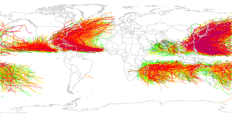 IBTrACS storm tracks for seasons 1947 through 2007.
The International Best Track Archive for Climate Stewardship (IBTrACS) dataset was developed by the NOAA National Climatic Data Center, which took the initial step of synthesizing and merging best track data from all official Tropical Cyclone Warning Centers (TCWCs) and the WMO Regional Specialized Meteorological Centers (RSMCs) who are responsible for developing and archiving best track data worldwide. In recognizing the deficiency in global tropical cyclone data, and the lack of a publically available dataset, the IBTrACS dataset was produced, which, for the first time, combines existing best track data from over 10 international forecast centers. The dataset contains the position, maximum sustained winds, minimum central pressure, and storm nature for every tropical cyclone globally at 6-hr intervals in UTC. Statistics from the merge are also provided (such as number of centers tracking the storm, range in pressure, median wind speed, etc.). The dataset period is from 1848 to the present with dataset updates performed annually in August. The dataset is archived as netCDF files but can be accessed via a variety of user-friendly formats to facilitate data analysis, including netCDF, Shapefile, and CSV formatted files. The update to version 3 data includes new data sources, bug fixes, shapefile-support, discontinued support of ASCII and new variables.
- Cite as: Kenneth R. Knapp, Scott Applequist, Howard J. Diamond, James P. Kossin, Michael Kruk, and Carl Schreck (2010). NCDC International Best Track Archive for Climate Stewardship (IBTrACS) Project, Version 3. [indicate subset used]. NOAA National Centers for Environmental Information. DOI:10.7289/V5NK3BZP [access date].
- Please refer to Credit tab for full citation information.
| Search Data |
|
| Download Data |
|
| Distribution Formats |
- netCDF (Version: 3)
- File Specification: NetCDF Climate and Forecast (CF) Metadata Convention (http://cf-pcmdi.llnl.gov/)
- CSV
- Shapefile
- WMS
- cXML WMO format
- HURDAT tape format
- XML
|
| Ordering Instructions |
Contact NCEI for other distribution options and instructions. |
| Distributor |
NOAA National Centers for Environmental Information
ncei.info@noaa.gov
|
| Dataset Point of Contact |
IBTrACS Dataset POC
DOC/NOAA/NESDIS/NCEI > National Centers for Environmental Information, NESDIS, NOAA, U.S. Department of Commerce
+1 (828) 271-4339
IBTrACS.Team@noaa.gov
|
| Time Period |
1848-01-01 to Present |
| Spatial Bounding Box Coordinates |
West: -180.0
East: 180.0
South: -80.0
North: 80.0
|
| Spatial Coverage Map |
|
| Dataset Information |
|
| General Documentation |
|
| Processing Documents |
- Previous IBTrACS Dataset Releases
|
| Associated Resources |
- The International Best Track Archive for Climate Stewardship (IBTrACS): Unifying tropical cyclone best track data.
- NCDC International Best Track Archive for Climate Stewardship (IBTrACS) Project, Version 2 (Version Superseded)
|
| Publication Dates |
- publication: 2010-09-01
- revision: 2010-09-17
- revision: 2011-07-19
- revision: 2012-10-01
- revision: 2013-10-31
- revision: 2014-09-02
|
| Edition |
Version 3 |
| Data Presentation Form |
Digital table - digital representation of facts or figures systematically displayed, especially in columns
|
| Dataset Progress Status |
Complete - production of the data has been completed |
| Data Update Frequency |
Annually |
| Purpose |
The major constraint in improving scientific understanding of the observed trends and variability of tropical cyclone activity has been a lack of accurate, quality controlled best track data for all tropical cyclone basins globally. |
| Dataset Citation |
- Cite as: Kenneth R. Knapp, Scott Applequist, Howard J. Diamond, James P. Kossin, Michael Kruk, and Carl Schreck (2010). NCDC International Best Track Archive for Climate Stewardship (IBTrACS) Project, Version 3. [indicate subset used]. NOAA National Centers for Environmental Information. DOI:10.7289/V5NK3BZP [access date].
- Publications using IBTrACS should also cite the following journal article: Knapp, K. R., M. C. Kruk, D. H. Levinson, H. J. Diamond, and C. J. Neumann, 2010: The International Best Track Archive for Climate Stewardship (IBTrACS): Unifying tropical cyclone best track data. Bulletin of the American Meteor. Society, 91, 363-376. doi:10.1175/2009BAMS2755.1
|
| Cited Authors |
- User Engagement and Services Branch
DOC/NOAA/NESDIS/NCDC > National Climatic Data Center, NESDIS, NOAA, U.S. Department of Commerce
|
| Originators |
- User Engagement and Services Branch
DOC/NOAA/NESDIS/NCDC > National Climatic Data Center, NESDIS, NOAA, U.S. Department of Commerce
|
| Publishers |
- DOC/NOAA/NESDIS/NCEI > National Centers for Environmental Information, NESDIS, NOAA, U.S. Department of Commerce
- DOC/NOAA/NESDIS/NCDC > National Climatic Data Center, NESDIS, NOAA, U.S. Department of Commerce
|
| Acknowledgments |
- The following organizations provided best track data which are included in the IBTrACS data set: * Australian Bureau of Meteorology * Chinese Meteorological Agency Shanghai Typhoon Institute * Hong Kong Observatory * Joint Typhoon Warning Center * RSMC Honolulu, HI, USA (NOAA Central Pacific Hurricane Center) * RSMC La Reunion * RSMC Miami, FL, USA (NOAA Tropical Prediction Center) (HURDAT) * RSMC Nadi, Fiji * RSMC New Delhi, India * RSMC Tokyo, Japan * TCWC Wellington, New Zealand Also, special thanks to * the NCDC Climate Database Modernization Program (CDMP) for digitizing hardcopies of best track data. * Charlie Neumann, for making his Southern Hemisphere dataset available for this work
|
| Theme keywords |
Global Change Master Directory (GCMD) Science Keywords
- Earth Science > Atmosphere > Weather Events > Tropical Cyclones
- Earth Science > Human Dimensions > Natural Hazards > Tropical Cyclones > Hurricanes
- Earth Science > Atmosphere > Weather Events > Monsoons
- Earth Science > Atmosphere > Weather Events > Rain Storms
- Earth Science > Human Dimensions > Natural Hazards > Tropical Cyclones > Typhoons
- Earth Science > Atmosphere > Atmospheric Winds > Boundary Layer Winds
- Earth Science > Atmosphere > Atmospheric Pressure > Anticyclones/Cyclones
- Earth Science > Atmosphere > Atmospheric Pressure > Sea Level Pressure
- Earth Science > Atmosphere > Atmospheric Winds > Surface Winds
- Earth Science > Oceans > Ocean Pressure > Sea Level Pressure
- Earth Science > Oceans > Ocean Winds > Surface Winds
- Earth Science > Oceans > Coastal Processes > Storm Surge
|
| Data Center keywords |
Global Change Master Directory (GCMD) Data Center Keywords
- DOC/NOAA/NESDIS/NCEI > National Centers for Environmental Information, NESDIS, NOAA, U.S. Department of Commerce
- DOC/NOAA/NESDIS/NCDC > National Climatic Data Center, NESDIS, NOAA, U.S. Department of Commerce
|
| Place keywords |
Global Change Master Directory (GCMD) Location Keywords
- Geographic Region > Equatorial
- Geographic Region > Global Ocean
- Geographic Region > Mid-Latitude
- Geographic Region > Tropics
- Ocean > Atlantic Ocean > South Atlantic Ocean
- Ocean > Atlantic Ocean > North Atlantic Ocean
- Ocean > Indian Ocean
- Ocean > Pacific Ocean > Eastern Pacific Ocean
- Ocean > Pacific Ocean > North Pacific Ocean
- Ocean > Pacific Ocean > South Pacific Ocean
- Ocean > Pacific Ocean > Western Pacific Ocean
|
| Stratum keywords |
Global Change Master Directory (GCMD) Location Keywords
- Vertical Location > Sea Surface
- Vertical Location > Land Surface
|
| Use Constraints |
- Cite as: Kenneth R. Knapp, Scott Applequist, Howard J. Diamond, James P. Kossin, Michael Kruk, and Carl Schreck (2010). NCDC International Best Track Archive for Climate Stewardship (IBTrACS) Project, Version 3. [indicate subset used]. NOAA National Centers for Environmental Information. DOI:10.7289/V5NK3BZP [access date].
- Publications using IBTrACS should also cite the following journal article: Knapp, K. R., M. C. Kruk, D. H. Levinson, H. J. Diamond, and C. J. Neumann, 2010: The International Best Track Archive for Climate Stewardship (IBTrACS): Unifying tropical cyclone best track data. Bulletin of the American Meteor. Society, 91, 363-376. doi:10.1175/2009BAMS2755.1
- Use liability: NOAA and NCEI cannot provide any warranty as to the accuracy, reliability, or completeness of furnished data. Users assume responsibility to determine the usability of these data. The user is responsible for the results of any application of this data for other than its intended purpose.
|
| Access Constraints |
- Distribution liability: NOAA and NCEI make no warranty, expressed or implied, regarding these data, nor does the fact of distribution constitute such a warranty. NOAA and NCEI cannot assume liability for any damages caused by any errors or omissions in these data. If appropriate, NCEI can only certify that the data it distributes are an authentic copy of the records that were accepted for inclusion in the NCEI archives.
|
| Fees |
- In most cases, electronic downloads of the data are free. However, fees may apply for custom orders, data certifications, copies of analog materials, and data distribution on physical media.
|
| Lineage information for: dataset |
|---|
| Lineage Statement |
Data were obtained from numerous sources. Upon receipt of the electronic files, data were converted to common format (netCDF). Thereafter, numerous merging procedures were implemented, including an assessment of storm position, the identification of unique storms, and an accounting for a variety of storm tracks, storm splits, and storm mergers. An automated algorithm was developed to identify storms tracked by multiple centers by sorting storms in time and space. Any observations at identical times and within 111 kilometers, were identified as identical storms. Once a TC was identified as unique, a storm serial number was created which distinctively numbers the storm. IBTrACS algorithms read all the individual storm tracks from the merged files and create one combined storm track with a single position, wind and pressure every 6 hours (at 00, 06, 12 and 18UTC). Objective automated quality control algorithms were developed and incorporated for the maximum sustained wind and minimum central pressure for each tropical cyclone and time step. These data are in netCDF, with one file per cyclone. Statistics from the merge are also provided (such as number of centers tracking the storm, range in pressure, median wind speed, etc.). |
| Processor |
- DOC/NOAA/NESDIS/NCDC > National Climatic Data Center, NESDIS, NOAA, U.S. Department of Commerce
- DOC/NOAA/NESDIS/NCDC > National Climatic Data Center, NESDIS, NOAA, U.S. Department of Commerce
|
| Processing Steps |
- Any observations at identical times and within 111 kilometers (approx. 1 degree latitude) were identified as identical storms. In order to create a dataset that was globally homogeneous, the maximum winds are standardize to a single 10-minute averaging period as it is the global standard set by the World Meteorological Organization.
- For more information, please view documentation for Version 3 of this dataset.
|
| Processing Documents |
- Previous IBTrACS Dataset Releases
|
| Source Datasets |
- Tropical Cyclone Data from the Australian Bureau of Meteorology
- Tropical Cyclone Data from the Shanghai Typhoon Institute, China Meteorological Administration
- Tropical Cyclone Data from Hong Kong Observatory
- Tropical Cyclone Data from the Joint Typhoon Warning Center
- Description of Source: Source dataset
- Temporal extent used: 1945-01-01 to Present
- Central Pacific Hurricane Center Home Page
- Meteo-France - Centre des Cyclones Tropicaux de la Reunion
- Hurricane Research Division Re-Analysis Project
- RSMC Nadi-Tropical Cyclone Centre, Fiji Meteorological Service
- International Best Track Data from RSMC Tokyo-Typhoon Center
- Tropical Cyclone Data from TCWC Wellington, New Zealand Meteorological Service
- Southern Hemisphere dataset
-
Southern Hemisphere dataset (FTP) (download)
Download the Tropical Cyclone Data of the Southern Hemisphere - FTP Data Download
- Description of Source: Source dataset
- Temporal extent used: 1960-01-01 to 2007-12-31
- Global Tropcial Cyclone "Best Track" Position and Intensity Data - ds824.1
- Global Consolidated Tropical Cyclone Data
- Description of Source: Source dataset
- Temporal extent used: 1842-01-01 to 1989-12-31
- Typhoons Analogs
- Description of Source: Source dataset
- Temporal extent used: 1945-01-01 to 1976-12-31
|
| Lineage information for: repository |
|---|
| Processing Steps |
- 2015-04-22T00:00:00 - NOAA created the National Centers for Environmental Information (NCEI) by merging NOAA's National Climatic Data Center (NCDC), National Geophysical Data Center (NGDC), and National Oceanographic Data Center (NODC), including the National Coastal Data Development Center (NCDDC), per the Consolidated and Further Continuing Appropriations Act, 2015, Public Law 113-235. NCEI launched publicly on April 22, 2015.
|
Last Modified: 2023-06-23
For questions about the information on this page, please email:
ncei.info@noaa.gov