Dataset Overview | National Centers for Environmental Information (NCEI)

NOAA Climate Data Record (CDR) of Precipitation Estimation from Remotely Sensed Information using Artificial Neural Networks (PERSIANN-CDR), Version 1 Revision 1

Precipitation - PERSIANN-CDR

browse graphic
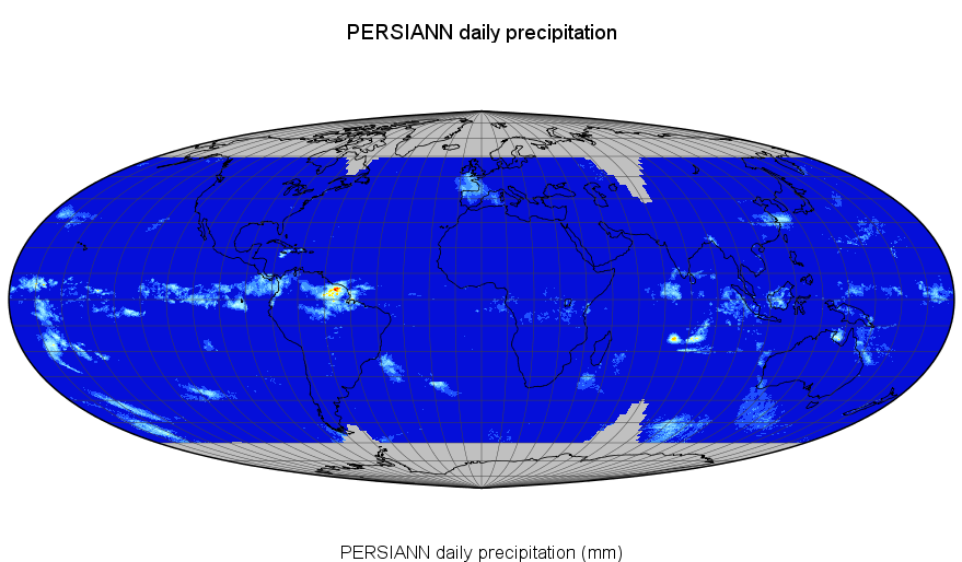
PERSIANN-CDR Daily Precipitation Example
PERSIANN Precipitation Climate Data Record (PERSIANN-CDR) is a daily quasi-global precipitation product for the period of 1982 to the present (note that there is a delay in data availability due to processing and data input availability). The data covers from 60 degrees S to 60 degrees N and 0 degrees to 360 degrees longitude at 0.25 degree spatial resolution. The product is developed using Gridded Satellite (GridSat-B1) IR data that are derived from merging ISCCP B1 IR data, along with GPCP version 2.2.
  • Cite as: Sorooshian, Soroosh; Hsu, Kuolin; Braithwaite, Dan; Ashouri, Hamed; and NOAA CDR Program (2014): NOAA Climate Data Record (CDR) of Precipitation Estimation from Remotely Sensed Information using Artificial Neural Networks (PERSIANN-CDR), Version 1 Revision 1. [indicate subset used]. NOAA National Centers for Environmental Information. doi:10.7289/V51V5BWQ [access date].
  • Please refer to Credit tab for full citation information.
gov.noaa.ncdc:C00854
Search Data
Download Data
Distribution Formats
  • netCDF (Version: 4)
    • File Specification: The NetCDF data files comply with the Climate and Forecast (CF) Metadata Conventions and the NetCDF Attribute Convention for Dataset Discovery (ACDD).
Ordering Instructions Contact NCEI for other distribution options and instructions.
Distributor NOAA National Centers for Environmental Information
ncei.info@noaa.gov
Dataset Point of Contact Customer Engagement Branch
NOAA National Centers for Environmental Information
1-828-271-4800
ncei.orders@noaa.gov
Dataset Point of Contact NOAA Climate Data Record Program Office
DOC/NOAA/NESDIS/NCEI > National Centers for Environmental Information, NESDIS, NOAA, U.S. Department of Commerce
+1 828-271-4800
cdr-ipt-PERSIANN@noaa.gov
Coverage Description
Time Period 1983-01-01 to Present (time interval: 1-day)
Spatial Bounding Box Coordinates
West: -180.0
East: 180.0
South: -60.0
North: 60.0
Spatial Coverage Map
General Documentation
Processing Documents
  • Source Code Package for Precipitation - PERSIANN-CDR
    • CDR Source Code (download)
      This source code is for reference only. The source code is provided to maintain transparency of the algorithm and processes used in creating the Climate Data Record (CDR). The source code is not intended to be portable to any computer system(s) beyond that of the original CDR producer's environment.
  • Precipitation - PERSIANN-CDR Flow Chart
  • Climate Algorithm Theoretical Basis Document for Precipitation - PERSIANN-CDR
Associated Resources
  • Data Stewardship Maturity Report for NOAA Climate Data Record (CDR) of Precipitation Estimation from Remotely Sensed Information using Artificial Neural Networks (PERSIANN-CDR), Version 1 Revision 1
  • Data Stewardship Maturity Report for NOAA Climate Data Record (CDR) of Precipitation Estimation from Remotely Sensed Information using Artificial Neural Networks (PERSIANN-CDR), Version 1 Revision 1
  • PERSIANN-CDR: Daily Precipitation Climate Data Record from Multi-Satellite Observations for Hydrological and Climate Studies
  • Center for Hydrometeorology & Remote Sensing - PERSIANN
Publication Dates
  • publication: 2014-06-01
  • revision: 2014-06-01
  • creation: 2013-05-31
Edition v01r01
Data Presentation Form Digital image
Dataset Progress Status Ongoing - data is continually being updated
Data Update Frequency Quarterly
Purpose This dataset provides a high quality Climate Data Record (CDR) of precipitation. Data are intended to support Climatologists, Hydrologists, Hydrometeorologists, and Hydroclimatologists in various forms of climate research, including extreme event (flood and drought) analysis.
Use Limitations
  • See the Algorithm Theoretical Basis Document for a description of the use limitations for this dataset.
Dataset Citation
  • Cite as: Sorooshian, Soroosh; Hsu, Kuolin; Braithwaite, Dan; Ashouri, Hamed; and NOAA CDR Program (2014): NOAA Climate Data Record (CDR) of Precipitation Estimation from Remotely Sensed Information using Artificial Neural Networks (PERSIANN-CDR), Version 1 Revision 1. [indicate subset used]. NOAA National Centers for Environmental Information. doi:10.7289/V51V5BWQ [access date].
  • Publications using this dataset should also cite the following journal article: Ashouri H., K. Hsu, S. Sorooshian, D. K. Braithwaite, K. R. Knapp, L. D. Cecil, B. R. Nelson, and O. P. Prat, 2015: PERSIANN-CDR: Daily Precipitation Climate Data Record from Multi-Satellite Observations for Hydrological and Climate Studies. Bull. Amer. Meteor. Soc., doi: https://doi.org/10.1175/BAMS-D-13-00068.1.
Cited Authors
  • Sorooshian, Soroosh
    UC-IRVINE/CHRS > Center for Hydrometeorology and Remote Sensing, University of California, Irvine
  • Hsu, Kuolin
    UC-IRVINE/CHRS > Center for Hydrometeorology and Remote Sensing, University of California, Irvine
  • Braithwaite, Dan
    UC-IRVINE/CHRS > Center for Hydrometeorology and Remote Sensing, University of California, Irvine
  • Ashouri, Hamed
    UC-IRVINE/CHRS > Center for Hydrometeorology and Remote Sensing, University of California, Irvine
  • NOAA CDR Program
    UC-IRVINE/CHRS > Center for Hydrometeorology and Remote Sensing, University of California, Irvine
Principal Investigators
  • Sorooshian, Soroosh
    UC-IRVINE/CHRS > Center for Hydrometeorology and Remote Sensing, University of California, Irvine
Collaborators
  • Hsu, Kuolin
    UC-IRVINE/CHRS > Center for Hydrometeorology and Remote Sensing, University of California, Irvine
  • Braithwaite, Dan
    UC-IRVINE/CHRS > Center for Hydrometeorology and Remote Sensing, University of California, Irvine
  • Ashouri, Hamed
    UC-IRVINE/CHRS > Center for Hydrometeorology and Remote Sensing, University of California, Irvine
  • NOAA CDR Program
    UC-IRVINE/CHRS > Center for Hydrometeorology and Remote Sensing, University of California, Irvine
Publishers
  • NOAA National Centers for Environmental Information
  • DOC/NOAA/NESDIS/NCDC > National Climatic Data Center, NESDIS, NOAA, U.S. Department of Commerce
Theme keywords Global Change Master Directory (GCMD) Science Keywords
  • Earth Science > Atmosphere > Precipitation > Precipitation Amount
  • Earth Science > Atmosphere > Precipitation > Precipitation Rate
  • Earth Science > Atmosphere > Precipitation > Liquid Precipitation > Rain
Global Climate Observing System (GCOS) Essential Climate Variables (ECVs)
  • Precipitation
Data Center keywords Global Change Master Directory (GCMD) Data Center Keywords
  • DOC/NOAA/NESDIS/NCDC > National Climatic Data Center, NESDIS, NOAA, U.S. Department of Commerce
  • DOC/NOAA/NESDIS/NCEI > National Centers for Environmental Information, NESDIS, NOAA, U.S. Department of Commerce
  • UC-IRVINE/CHRS > Center for Hydrometeorology and Remote Sensing, University of California, Irvine
Platform keywords Global Change Master Directory (GCMD) Platform Keywords
  • Earth Observation Satellites > GOES (Geostationary Operational Environmental Satellite)
  • Earth Observation Satellites > GMS (Japan Geostationary Meteorological Satellite)
  • Earth Observation Satellites > INSAT (Indian National Satellite)
  • Earth Observation Satellites > METEOSAT
  • Earth Observation Satellites > FY (Feng-Yun)
Place keywords Global Change Master Directory (GCMD) Location Keywords
  • Geographic Region > Global
Project keywords Global Change Master Directory (GCMD) Project Keywords
  • NOAA Climate Data Record (CDR) Program
  • NOAA OneStop Project
Data Resolution keywords Global Change Master Directory (GCMD) Vertical Data Resolution Keywords
  • > 1 km
Global Change Master Directory (GCMD) Temporal Data Resolution Keywords
  • Hourly - < Daily
Global Change Master Directory (GCMD) Horizontal Data Resolution Keywords
  • 10 km - < 50 km or approximately .09 degree - < .5 degree
Stratum keywords Global Change Master Directory (GCMD) Location Keywords
  • Vertical Location > Land Surface
  • Vertical Location > Sea Surface
Use Constraints
  • Cite as: Sorooshian, Soroosh; Hsu, Kuolin; Braithwaite, Dan; Ashouri, Hamed; and NOAA CDR Program (2014): NOAA Climate Data Record (CDR) of Precipitation Estimation from Remotely Sensed Information using Artificial Neural Networks (PERSIANN-CDR), Version 1 Revision 1. [indicate subset used]. NOAA National Centers for Environmental Information. doi:10.7289/V51V5BWQ [access date].
  • Publications using this dataset should also cite the following journal article: Ashouri H., K. Hsu, S. Sorooshian, D. K. Braithwaite, K. R. Knapp, L. D. Cecil, B. R. Nelson, and O. P. Prat, 2015: PERSIANN-CDR: Daily Precipitation Climate Data Record from Multi-Satellite Observations for Hydrological and Climate Studies. Bull. Amer. Meteor. Soc., doi: https://doi.org/10.1175/BAMS-D-13-00068.1.
  • See the Use Agreement for this CDR available on the CDR page.
  • Use liability: NOAA and NCEI cannot provide any warranty as to the accuracy, reliability, or completeness of furnished data. Users assume responsibility to determine the usability of these data. The user is responsible for the results of any application of this data for other than its intended purpose.
Access Constraints
  • Distribution liability: NOAA and NCEI make no warranty, expressed or implied, regarding these data, nor does the fact of distribution constitute such a warranty. NOAA and NCEI cannot assume liability for any damages caused by any errors or omissions in these data. If appropriate, NCEI can only certify that the data it distributes are an authentic copy of the records that were accepted for inclusion in the NCEI archives.
Fees
  • In most cases, electronic downloads of the data are free. However, fees may apply for custom orders, data certifications, copies of analog materials, and data distribution on physical media.
Lineage information for: repository
Processing Steps
  • 2015-04-22T00:00:00 - NOAA created the National Centers for Environmental Information (NCEI) by merging NOAA's National Climatic Data Center (NCDC), National Geophysical Data Center (NGDC), and National Oceanographic Data Center (NODC), including the National Coastal Data Development Center (NCDDC), per the Consolidated and Further Continuing Appropriations Act, 2015, Public Law 113-235. NCEI launched publicly on April 22, 2015.
Last Modified: 2023-08-10
For questions about the information on this page, please email: ncei.info@noaa.gov