Hurricane Satellite (HURSAT) Microwave (MW)
HURSAT MW
 HURSAT-MW
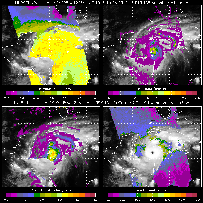
The Hurricane Satellite (HURSAT) from Microwave (MW) observations of tropical cyclones worldwide data consist of raw satellite observations. The data derive from the global constellation of geostationary satellites (GOES, Meteosat, MS, and FY2 series) spanning 1987 through 2009. Passive microwave observations provide significant information content given that most clouds are transparent at microwave wavelengths. The HURSAT-MW data set is constructed in largely the same manner as HURSAT-B1. Each time a Defense Meteorological Satellite Program (DMSP) satellite passes over a tropical cyclone, Special Sensing Microwave Imager (SSMI) data are mapped to an equal angle grid (fixed latitude/longitude) centered on the temporally interpolated storm location. HURSAT-MW provides brightness temperatures for all 7 SSMI channels. No product retrievals (e.g., rain rate, total column water vapor, ...) are provided in the data, but are possible (e.g., view the imagery derived from the data). The satellite data were then gridded to 8km, with grid centers fixed on the tropical cyclone center of circulation at 6-hour intervals. Data include hurricanes from the Atlantic, Pacific and Indian Ocean Basins. Data are provided in a convenient NetCDF format which is self-documenting and follows standard storage and metadata conventions. Version 5 supersedes all other versions.
- Cite as: Knapp, K. R. and J. P. Kossin, Hurricane Satellite (HURSAT) Microwave (MW), Version 5.0 [indicate subset used]. NOAA National Climatic Data Center. doi:10.7289/V50Z716H [access date].
- Please refer to Credit tab for full citation information.
| Download Data |
|
| Distribution Formats |
|
| Ordering Instructions |
Contact NCEI for other distribution options and instructions. |
| Distributor |
NOAA National Centers for Environmental Information
ncei.info@noaa.gov
|
| Dataset Point of Contact |
Customer Engagement Branch
DOC/NOAA/NESDIS/NCEI > National Centers for Environmental Information, NESDIS, NOAA, U.S. Department of Commerce
+1 (828) 271-4800
ncdc.satorders@noaa.gov
|
| Coverage Description |
|
| Time Period |
1987-07-10 to 2009-12-14 (time interval: 6-hour) |
| Spatial Bounding Box Coordinates |
West: -180.0
East: 180.0
South: -90.0
North: 90.0
|
| Spatial Coverage Map |
|
| Dataset Information |
|
| General Documentation |
|
| Associated Resources |
- New global tropical cyclone data from ISCCP B1 geostationary satellite observations
- HURSAT Documentation for Version 5
- Hurricane Satellite (HURSAT) from International Satellite Cloud Climatology Project (ISCCP) B1
-
HURSAT B
Landing page for related dataset
- Hurricane Satellite (HURSAT) from Advanced Very High Resolution Radiometer (AVHRR)
|
| Publication Dates |
|
| Edition |
Version 5.0 |
| Data Presentation Form |
Digital image
|
| Dataset Progress Status |
Ongoing - data is continually being updated |
| Data Update Frequency |
Irregular |
| Purpose |
To provide a cohesive data set of historical tropical cyclone centered imagery for future analysis. |
| Use Limitations |
- The data are not original resolution satellite data. Instead, all images are approximately 8km resolution.
|
| Dataset Citation |
- Cite as: Knapp, K. R. and J. P. Kossin, Hurricane Satellite (HURSAT) Microwave (MW), Version 5.0 [indicate subset used]. NOAA National Climatic Data Center. doi:10.7289/V50Z716H [access date].
- Also cite this paper when data is used as a source: Knapp, K. R. and J. P. Kossin, 2007:New global tropical cyclone data from ISCCP B1 geostationary satellite observations.Journal of Applied Remote Sensing, 1, 013505. doi:10.1117/1.2712816
|
| Cited Authors |
- Knapp, Ken
DOC/NOAA/NESDIS/NCDC > National Climatic Data Center, NESDIS, NOAA, U.S. Department of Commerce
- Kossin, James
DOC/NOAA/NESDIS/NCDC > National Climatic Data Center, NESDIS, NOAA, U.S. Department of Commerce
|
| Originators |
- Knapp, Ken
DOC/NOAA/NESDIS/NCDC > National Climatic Data Center, NESDIS, NOAA, U.S. Department of Commerce
|
| Collaborators |
- Kossin, James
DOC/NOAA/NESDIS/NCDC > National Climatic Data Center, NESDIS, NOAA, U.S. Department of Commerce
|
| Publishers |
- DOC/NOAA/NESDIS/NCEI > National Centers for Environmental Information, NESDIS, NOAA, U.S. Department of Commerce
|
| Theme keywords |
Global Change Master Directory (GCMD) Science Keywords
- Earth Science > Atmosphere > Weather Events > Tropical Cyclones
- Earth Science > Human Dimensions > Natural Hazards > Tropical Cyclones > Hurricanes
- Earth Science > Human Dimensions > Natural Hazards > Tropical Cyclones > Typhoons
- Earth Science > Atmosphere > Atmospheric Pressure > Anticyclones/Cyclones
- Earth Science > Atmosphere > Atmospheric Pressure > Sea Level Pressure
- Earth Science > Atmosphere > Clouds
- Earth Science > Atmosphere > Atmospheric Water Vapor
- Earth Science > Atmosphere > Atmospheric Winds
- Earth Science > Spectral/Engineering > Microwave > Brightness Temperature
|
| Data Center keywords |
Global Change Master Directory (GCMD) Data Center Keywords
- DOC/NOAA/NESDIS/NCDC > National Climatic Data Center, NESDIS, NOAA, U.S. Department of Commerce
- DOC/NOAA/NESDIS/NCEI > National Centers for Environmental Information, NESDIS, NOAA, U.S. Department of Commerce
|
| Platform keywords |
Global Change Master Directory (GCMD) Platform Keywords
- DMSP 5D-2/F10 > Defense Meteorological Satellite Program-F10
- DMSP 5D-2/F11 > Defense Meteorological Satellite Program-F11
- DMSP 5D-2/F13 > Defense Meteorological Satellite Program-F13
- DMSP 5D-2/F14 > Defense Meteorological Satellite Program-F14
- DMSP 5D-3/F15 > Defense Meteorological Satellite Program-F15
- DMSP 5D-2/F08 > Defense Meteorological Satellite Program-F08
|
| Instrument keywords |
Global Change Master Directory (GCMD) Instrument Keywords
- SSMI > Special Sensor Microwave/Imager
- SSMIS > Special Sensor Microwave Imager/Sounder
|
| Place keywords |
Global Change Master Directory (GCMD) Location Keywords
- Geographic Region > Global
- Geographic Region > Equatorial
- Geographic Region > Global Ocean
|
| Stratum keywords |
Global Change Master Directory (GCMD) Location Keywords
- Vertical Location > Sea Surface
- Vertical Location > Land Surface
|
| Use Constraints |
- Cite as: Knapp, K. R. and J. P. Kossin, Hurricane Satellite (HURSAT) Microwave (MW), Version 5.0 [indicate subset used]. NOAA National Climatic Data Center. doi:10.7289/V50Z716H [access date].
- Also cite this paper when data is used as a source: Knapp, K. R. and J. P. Kossin, 2007:New global tropical cyclone data from ISCCP B1 geostationary satellite observations.Journal of Applied Remote Sensing, 1, 013505. doi:10.1117/1.2712816
- Use liability: NOAA and NCEI cannot provide any warranty as to the accuracy, reliability, or completeness of furnished data. Users assume responsibility to determine the usability of these data. The user is responsible for the results of any application of this data for other than its intended purpose.
|
| Access Constraints |
- Distribution liability: NOAA and NCEI make no warranty, expressed or implied, regarding these data, nor does the fact of distribution constitute such a warranty. NOAA and NCEI cannot assume liability for any damages caused by any errors or omissions in these data. If appropriate, NCEI can only certify that the data it distributes are an authentic copy of the records that were accepted for inclusion in the NCEI archives.
|
| Fees |
- In most cases, electronic downloads of the data are free. However, fees may apply for custom orders, data certifications, copies of analog materials, and data distribution on physical media.
|
| Lineage information for: dataset |
|---|
| Lineage Statement |
Each time a Defense Meteorological Satellite Program (DMSP) satellite passes over a tropical cyclone, Special Sensing Microwave Imager (SSMI) data are mapped to an equal angle grid (fixed latitude/longitude) centered on the temporally interpolated storm location. IBTrACS data were temporally-interpolated to match the satellite data resolution. The satellite data were then gridded to 8km, with grid centers fixed on the tropical cyclone center of circulation. |
| Lineage information for: repository |
|---|
| Processing Steps |
- 2015-04-22T00:00:00 - NOAA created the National Centers for Environmental Information (NCEI) by merging NOAA's National Climatic Data Center (NCDC), National Geophysical Data Center (NGDC), and National Oceanographic Data Center (NODC), including the National Coastal Data Development Center (NCDDC), per the Consolidated and Further Continuing Appropriations Act, 2015, Public Law 113-235. NCEI launched publicly on April 22, 2015.
|
Last Modified: 2023-06-23
For questions about the information on this page, please email:
ncei.info@noaa.gov