NOAA JPSS Microwave Integrated Retrieval System (MIRS) Advanced Technology Microwave Sounder (ATMS) Precipitation and Surface Products from NDE
- referenceSystemInfo
- identificationInfo
- contentInfo
- distributionInfo
- dataQualityInfo
- dataQualityInfo
- dataQualityInfo
- metadataMaintenance
(MI_Metadata)
fileIdentifier: gov.noaa.ncdc:C00865
language: eng; USA
characterSet: (MD_CharacterSetCode) utf8
hierarchyLevel: (MD_ScopeCode) dataset
contact: (CI_ResponsibleParty)
organisationName: NOAA National Centers for Environmental Information
contactInfo: (CI_Contact)
address: (CI_Address)
electronicMailAddress: ncei.info@noaa.gov
onlineResource: (CI_OnlineResource)
linkage: https://www.ncei.noaa.gov/contact
name: NCEI Contact Information
description: Information for contacts at NCEI.
function: (CI_OnLineFunctionCode) information
role: (CI_RoleCode) pointOfContact
dateStamp: 2023-06-23
metadataStandardName: ISO 19115-2 Geographic Information - Metadata - Part 2: Extensions for Imagery and Gridded Data
metadataStandardVersion: ISO 19115-2:2009(E)
return to top
referenceSystemInfo: (MD_ReferenceSystem)
referenceSystemIdentifier: (RS_Identifier)
authority: (CI_Citation)
title: EPSG Geodetic Parameter Dataset Registry
date: (CI_Date)
date: 2008-11-12
dateType: (CI_DateTypeCode) publication
citedResponsibleParty: (CI_ResponsibleParty)
organisationName: International Association of Oil and Gas Producers (OGP) Geomatics Committee
contactInfo: (CI_Contact)
onlineResource: (CI_OnlineResource)
linkage: http://www.epsg-registry.org/
applicationProfile: Data Search Application
name: EPSG Geodetic Parameter Dataset Registry Application
description: Interface to the EPSG Geodetic Parameter Dataset Registry
function: (CI_OnLineFunctionCode) search
role: (CI_RoleCode) custodian
citedResponsibleParty: (CI_ResponsibleParty)
organisationName: International Association of Oil and Gas Producers (OGP) Geomatics Committee
contactInfo: (CI_Contact)
onlineResource: (CI_OnlineResource)
linkage: http://www.epsg-registry.org/export.htm?gml=urn:ogc:def:crs:EPSG::4326
applicationProfile: Download
name: Coordinate Reference System data in GML
description: Coordinate Reference System data in GML
function: (CI_OnLineFunctionCode) download
role: (CI_RoleCode) custodian
code: urn:ogc:def:crs:EPSG::4326
version: (unknown)
return to top
identificationInfo: (MD_DataIdentification)
citation: (CI_Citation)
title: NOAA JPSS Microwave Integrated Retrieval System (MIRS) Advanced Technology Microwave Sounder (ATMS) Precipitation and Surface Products from NDE
alternateTitle: MIRS-IMG-NDE
date: (CI_Date)
date: 2014-04-07
dateType: (CI_DateTypeCode) publication
edition: Version 11
identifier: (MD_Identifier)
code:
Anchor: DOI doi:10.7289/V51V5C1X
identifier: (MD_Identifier)
code: gov.noaa.ncdc:C00865
identifier: (MD_Identifier)
code: gov.noaa.class:JPSS_SND
citedResponsibleParty: (CI_ResponsibleParty)
organisationName: NOAA National Centers for Environmental Information
role: (CI_RoleCode) publisher
citedResponsibleParty: (CI_ResponsibleParty)
individualName: Liu, Quanhua
organisationName: DOC/NOAA/NESDIS/STAR > Center for Satellite Applications and Research, NESDIS, NOAA, U.S. Department of Commerce
role: (CI_RoleCode) principalInvestigator
citedResponsibleParty: (CI_ResponsibleParty)
individualName: Liu, Quanhua
organisationName: DOC/NOAA/NESDIS/STAR > Center for Satellite Applications and Research, NESDIS, NOAA, U.S. Department of Commerce
role: (CI_RoleCode) author
citedResponsibleParty: (CI_ResponsibleParty)
individualName: Zhao, Limin
organisationName: DOC/NOAA/NESDIS/OSPO > Office of Satellite and Product Operations, NESDIS, NOAA, U.S. Department of Commerce
role: (CI_RoleCode) principalInvestigator
citedResponsibleParty: (CI_ResponsibleParty)
individualName: Zhao, Limin
organisationName: DOC/NOAA/NESDIS/OSPO > Office of Satellite and Product Operations, NESDIS, NOAA, U.S. Department of Commerce
role: (CI_RoleCode) author
citedResponsibleParty: (CI_ResponsibleParty)
individualName: Grassotti, Chris
organisationName: DOC/NOAA/NESDIS/STAR > Center for Satellite Applications and Research, NESDIS, NOAA, U.S. Department of Commerce
role: (CI_RoleCode) collaborator
citedResponsibleParty: (CI_ResponsibleParty)
individualName: Grassotti, Chris
organisationName: DOC/NOAA/NESDIS/STAR > Center for Satellite Applications and Research, NESDIS, NOAA, U.S. Department of Commerce
role: (CI_RoleCode) author
citedResponsibleParty: (CI_ResponsibleParty)
organisationName: NOAA JPSS Program Office
role: (CI_RoleCode) originator
citedResponsibleParty: (CI_ResponsibleParty)
organisationName: NOAA JPSS Program Office
role: (CI_RoleCode) author
presentationForm: (CI_PresentationFormCode) imageDigital
abstract: This dataset contains two-dimensional precipitation and surface products from the JPSS Microwave Integrated Retrieval System (MIRS) using sensor data from the Advanced Technology Microwave Sounder (ATMS) onboard the Suomi National Polar-orbiting Partnership (S-NPP) satellite. ATMS is a cross-track scanner with 22 channels in spectral bands from 23 GHz through 183 GHz. MIRS was developed by the NOAA/NESDIS Center for Satellite Application and Research (STAR) and is produced operationally at the NOAA/NESDIS Office of Satellite and Product Operations (OSPO). The precipitation and surface products file, or imaging (IMG) products file, contains total precipitable water (TPW), skin temperature, emissivity by channel, rain rate, cloud liquid water (CLW), rain water path (RWP), ice water path (IWP), liquid water path (LWP), sea ice concentration, snow water equivalent (SWE), snow cover extent, and surface type classification. Quality control metrics and flags defining retrieval product quality are also provided. Each product file encompasses one 32-second granule of data, corresponding to 4 scan lines of ATMS data. The products are distributed in netCDF-4 file format with metadata attributes included.
purpose: This dataset provides high quality measurements of precipitation and surface products from ATMS.
status: (MD_ProgressCode) onGoing
pointOfContact: (CI_ResponsibleParty)
organisationName: DOC/NOAA/NESDIS/NCEI > National Centers for Environmental Information, NESDIS, NOAA, U.S. Department of Commerce
contactInfo: (CI_Contact)
address: (CI_Address)
electronicMailAddress: ncei.sat.info@noaa.gov
role: (CI_RoleCode) pointOfContact
resourceMaintenance: (MD_MaintenanceInformation)
maintenanceAndUpdateFrequency: (MD_MaintenanceFrequencyCode) continual
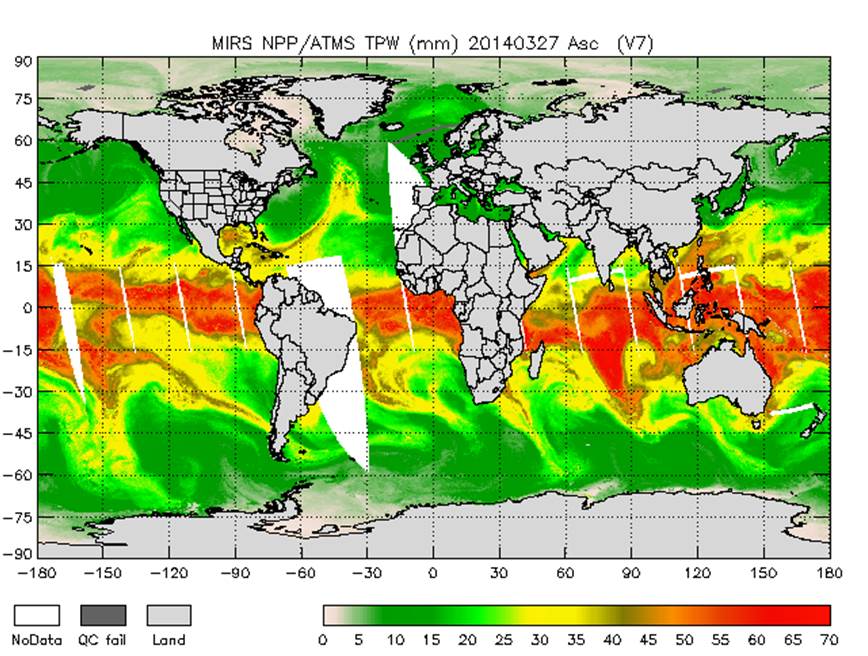
graphicOverview: (MD_BrowseGraphic)
fileName: https://www.ncei.noaa.gov/pub/data/metadata/images/C00865_MIRS_TPW.jpg
fileDescription: MIRS ATMS global ascending total precipitable water (TPW) from March 27, 2014. Image courtesy of NOAA OSPO.
fileType: JPEG
descriptiveKeywords: (MD_Keywords)
keyword: Earth Science > Atmosphere > Atmospheric Radiation > Emissivity
keyword: Earth Science > Atmosphere > Atmospheric Water Vapor > Water Vapor Indicators > Total Precipitable Water
keyword: Earth Science > Atmosphere > Clouds > Cloud Microphysics > Cloud Liquid Water/Ice
keyword: Earth Science > Atmosphere > Precipitation > Solid Precipitation > Snow
keyword: Earth Science > Atmosphere > Precipitation > Precipitation Rate
keyword: Earth Science > Cryosphere > Sea Ice > Sea Ice Concentration
keyword: Earth Science > Cryosphere > Snow/Ice > Snow Cover
keyword: Earth Science > Land Surface > Surface Thermal Properties > Skin Temperature
keyword: Earth Science > Spectral/Engineering > Microwave > Brightness Temperature
type: (MD_KeywordTypeCode) theme
thesaurusName: (CI_Citation)
title: Global Change Master Directory (GCMD) Science Keywords
date: (CI_Date)
date: 2018
dateType: (CI_DateTypeCode) revision
edition: Version 8.6
citedResponsibleParty: (CI_ResponsibleParty)
organisationName: Global Change Data Center, Science and Exploration Directorate, Goddard Space Flight Center (GSFC) National Aeronautics and Space Administration (NASA)
contactInfo: (CI_Contact)
onlineResource: (CI_OnlineResource)
linkage: https://earthdata.nasa.gov/about/gcmd/global-change-master-directory-gcmd-keywords
protocol: HTTPS
applicationProfile: Web Browser
name: Global Change Master Directory (GCMD) Keywords
description: The information provided on this page seeks to define how the GCMD Keywords are structured, used and accessed. It also provides information on how users can participate in the further development of the keywords.
function: (CI_OnLineFunctionCode) information
role: (CI_RoleCode) publisher
descriptiveKeywords: (MD_Keywords)
keyword: Terrestrial - Snow Cover
keyword: Atmospheric - Upper-air - Upper-air Water Vapour
keyword: Oceanic - Surface - Sea Ice
keyword: Atmospheric - Upper-air - Cloud Properties
type: (MD_KeywordTypeCode) theme
thesaurusName: (CI_Citation)
title: Global Climate Observing System (GCOS) Essential Climate Variables (ECVs)
date: (CI_Date)
date: 2017
dateType: (CI_DateTypeCode) publication
edition: Release 2017
citedResponsibleParty: (CI_ResponsibleParty)
organisationName: World Meteorological Organization, United Nations
contactInfo: (CI_Contact)
onlineResource: (CI_OnlineResource)
linkage: https://public.wmo.int/en/programmes/global-climate-observing-system/essential-climate-variables
protocol: HTTP
applicationProfile: Information
name: GCOS Essential Climate Variables
description: Overview of the GCOS Essential Climate Variables.
function: (CI_OnLineFunctionCode) information
role: (CI_RoleCode) custodian
descriptiveKeywords: (MD_Keywords)
keyword: Geographic Region > Global
type: (MD_KeywordTypeCode) place
thesaurusName: (CI_Citation)
title: Global Change Master Directory (GCMD) Location Keywords
date: (CI_Date)
date: 2018
dateType: (CI_DateTypeCode) revision
edition: Version 8.6
citedResponsibleParty: (CI_ResponsibleParty)
organisationName: Global Change Data Center, Science and Exploration Directorate, Goddard Space Flight Center (GSFC) National Aeronautics and Space Administration (NASA)
contactInfo: (CI_Contact)
onlineResource: (CI_OnlineResource)
linkage: https://earthdata.nasa.gov/about/gcmd/global-change-master-directory-gcmd-keywords
protocol: HTTPS
applicationProfile: Web Browser
name: Global Change Master Directory (GCMD) Keywords
description: The information provided on this page seeks to define how the GCMD Keywords are structured, used and accessed. It also provides information on how users can participate in the further development of the keywords.
function: (CI_OnLineFunctionCode) information
role: (CI_RoleCode) publisher
descriptiveKeywords: (MD_Keywords)
keyword: Vertical Location > Troposphere
keyword: Vertical Location > Land Surface
keyword: Vertical Location > Boundary Layer
type: (MD_KeywordTypeCode) stratum
thesaurusName: (CI_Citation)
title: Global Change Master Directory (GCMD) Location Keywords
date: (CI_Date)
date: 2018
dateType: (CI_DateTypeCode) revision
edition: Version 8.6
citedResponsibleParty: (CI_ResponsibleParty)
organisationName: Global Change Data Center, Science and Exploration Directorate, Goddard Space Flight Center (GSFC) National Aeronautics and Space Administration (NASA)
contactInfo: (CI_Contact)
onlineResource: (CI_OnlineResource)
linkage: https://earthdata.nasa.gov/about/gcmd/global-change-master-directory-gcmd-keywords
protocol: HTTPS
applicationProfile: Web Browser
name: Global Change Master Directory (GCMD) Keywords
description: The information provided on this page seeks to define how the GCMD Keywords are structured, used and accessed. It also provides information on how users can participate in the further development of the keywords.
function: (CI_OnLineFunctionCode) information
role: (CI_RoleCode) publisher
descriptiveKeywords: (MD_Keywords)
keyword: NOAA OneStop Project
keyword: JPSS > Joint Polar Satellite System
type: (MD_KeywordTypeCode) project
thesaurusName: (CI_Citation)
title: Global Change Master Directory (GCMD) Project Keywords
date: (CI_Date)
date: 2018
dateType: (CI_DateTypeCode) revision
edition: Version 8.6
citedResponsibleParty: (CI_ResponsibleParty)
organisationName: Global Change Data Center, Science and Exploration Directorate, Goddard Space Flight Center (GSFC) National Aeronautics and Space Administration (NASA)
contactInfo: (CI_Contact)
onlineResource: (CI_OnlineResource)
linkage: https://earthdata.nasa.gov/about/gcmd/global-change-master-directory-gcmd-keywords
protocol: HTTPS
applicationProfile: Web Browser
name: Global Change Master Directory (GCMD) Keywords
description: The information provided on this page seeks to define how the GCMD Keywords are structured, used and accessed. It also provides information on how users can participate in the further development of the keywords.
function: (CI_OnLineFunctionCode) information
role: (CI_RoleCode) publisher
descriptiveKeywords: (MD_Keywords)
keyword: ATMS > Advanced Technology Microwave Sounder
type: (MD_KeywordTypeCode) instrument
thesaurusName: (CI_Citation)
title: Global Change Master Directory (GCMD) Instrument Keywords
date: (CI_Date)
date: 2018
dateType: (CI_DateTypeCode) revision
edition: Version 8.6
citedResponsibleParty: (CI_ResponsibleParty)
organisationName: Global Change Data Center, Science and Exploration Directorate, Goddard Space Flight Center (GSFC) National Aeronautics and Space Administration (NASA)
contactInfo: (CI_Contact)
onlineResource: (CI_OnlineResource)
linkage: https://earthdata.nasa.gov/about/gcmd/global-change-master-directory-gcmd-keywords
protocol: HTTPS
applicationProfile: Web Browser
name: Global Change Master Directory (GCMD) Keywords
description: The information provided on this page seeks to define how the GCMD Keywords are structured, used and accessed. It also provides information on how users can participate in the further development of the keywords.
function: (CI_OnLineFunctionCode) information
role: (CI_RoleCode) publisher
descriptiveKeywords: (MD_Keywords)
keyword: SUOMI-NPP > Suomi National Polar-orbiting Partnership
keyword: NOAA-20 > National Oceanic and Atmospheric Administration - 20
type: (MD_KeywordTypeCode) platform
thesaurusName: (CI_Citation)
title: Global Change Master Directory (GCMD) Platform Keywords
date: (CI_Date)
date: 2018
dateType: (CI_DateTypeCode) revision
edition: Version 8.6
citedResponsibleParty: (CI_ResponsibleParty)
organisationName: Global Change Data Center, Science and Exploration Directorate, Goddard Space Flight Center (GSFC) National Aeronautics and Space Administration (NASA)
contactInfo: (CI_Contact)
onlineResource: (CI_OnlineResource)
linkage: https://earthdata.nasa.gov/about/gcmd/global-change-master-directory-gcmd-keywords
protocol: HTTPS
applicationProfile: Web Browser
name: Global Change Master Directory (GCMD) Keywords
description: The information provided on this page seeks to define how the GCMD Keywords are structured, used and accessed. It also provides information on how users can participate in the further development of the keywords.
function: (CI_OnLineFunctionCode) information
role: (CI_RoleCode) publisher
descriptiveKeywords: (MD_Keywords)
keyword: 10 km - < 50 km or approximately .09 degree - < .5 degree
type: (MD_KeywordTypeCode) dataResolution
thesaurusName: (CI_Citation)
title: Global Change Master Directory (GCMD) Horizontal Data Resolution Keywords
date: (CI_Date)
date: 2018
dateType: (CI_DateTypeCode) revision
edition: Version 8.6
citedResponsibleParty: (CI_ResponsibleParty)
organisationName: Global Change Data Center, Science and Exploration Directorate, Goddard Space Flight Center (GSFC) National Aeronautics and Space Administration (NASA)
contactInfo: (CI_Contact)
onlineResource: (CI_OnlineResource)
linkage: https://earthdata.nasa.gov/about/gcmd/global-change-master-directory-gcmd-keywords
protocol: HTTPS
applicationProfile: Web Browser
name: Global Change Master Directory (GCMD) Keywords
description: The information provided on this page seeks to define how the GCMD Keywords are structured, used and accessed. It also provides information on how users can participate in the further development of the keywords.
function: (CI_OnLineFunctionCode) information
role: (CI_RoleCode) publisher
descriptiveKeywords: (MD_Keywords)
keyword: DOC/NOAA/NESDIS/NCDC > National Climatic Data Center, NESDIS, NOAA, U.S. Department of Commerce
keyword: DOC/NOAA/NESDIS/NCEI > National Centers for Environmental Information, NESDIS, NOAA, U.S. Department of Commerce
keyword: DOC/NOAA/NESDIS/STAR > Center for Satellite Applications and Research, NESDIS, NOAA, U.S. Department of Commerce
keyword: DOC/NOAA/NESDIS/OSPO > Office of Satellite and Product Operations, NESDIS, NOAA, U.S. Department of Commerce
type: (MD_KeywordTypeCode) dataCentre
thesaurusName: (CI_Citation)
title: Global Change Master Directory (GCMD) Data Center Keywords
date: (CI_Date)
date: 2018
dateType: (CI_DateTypeCode) revision
edition: Version 8.6
citedResponsibleParty: (CI_ResponsibleParty)
organisationName: Global Change Data Center, Science and Exploration Directorate, Goddard Space Flight Center (GSFC) National Aeronautics and Space Administration (NASA)
contactInfo: (CI_Contact)
onlineResource: (CI_OnlineResource)
linkage: https://earthdata.nasa.gov/about/gcmd/global-change-master-directory-gcmd-keywords
protocol: HTTPS
applicationProfile: Web Browser
name: Global Change Master Directory (GCMD) Keywords
description: The information provided on this page seeks to define how the GCMD Keywords are structured, used and accessed. It also provides information on how users can participate in the further development of the keywords.
function: (CI_OnLineFunctionCode) information
role: (CI_RoleCode) publisher
descriptiveKeywords: (MD_Keywords)
keyword: NDE > NESDIS Data Exploitation
type: (MD_KeywordTypeCode) project
descriptiveKeywords: (MD_Keywords)
keyword: gov.noaa.class:JPSS_SND
type: (MD_KeywordTypeCode) other
resourceConstraints: (MD_Constraints)
useLimitation: For a complete description of use limitations for this dataset, refer to the Algorithm Theoretical Basis Document.
resourceConstraints: (MD_LegalConstraints)
useConstraints: (MD_RestrictionCode) otherRestrictions
otherConstraints: Cite as: Liu, Quanhua, Zhao, Limin, Grassotti, Chris, and NOAA JPSS Program Office (2014): NOAA JPSS Microwave Integrated Retrieval System (MIRS) Advanced Technology Microwave Sounder (ATMS) Precipitation and Surface Products from NDE. [indicate subset used]. NOAA National Centers for Environmental Information. doi:10.7289/V51V5C1X [access date].
resourceConstraints: (MD_LegalConstraints)
accessConstraints: (MD_RestrictionCode) otherRestrictions
otherConstraints: Distribution liability: NOAA and NCEI make no warranty, expressed or implied, regarding these data, nor does the fact of distribution constitute such a warranty. NOAA and NCEI cannot assume liability for any damages caused by any errors or omissions in these data. If appropriate, NCEI can only certify that the data it distributes are an authentic copy of the records that were accepted for inclusion in the NCEI archives.
resourceConstraints: (MD_LegalConstraints)
useConstraints: (MD_RestrictionCode) otherRestrictions
otherConstraints: Use liability: NOAA and NCEI cannot provide any warranty as to the accuracy, reliability, or completeness of furnished data. Users assume responsibility to determine the usability of these data. The user is responsible for the results of any application of this data for other than its intended purpose.
aggregationInfo: (MD_AggregateInformation)
aggregateDataSetName: (CI_Citation)
title: JPSS Microwave Integrated Retrieval System (MIRS) Advanced Technology Microwave Sounder (ATMS) Sounding Products
date: (CI_Date)
date: 2014-04-07
dateType: (CI_DateTypeCode) publication
citedResponsibleParty: (CI_ResponsibleParty)
organisationName: DOC/NOAA/NESDIS/NCDC > National Climatic Data Center, NESDIS, NOAA, U.S. Department of Commerce
role: (CI_RoleCode) publisher
citedResponsibleParty: (CI_ResponsibleParty)
organisationName: (missing)
contactInfo: (CI_Contact)
onlineResource: (CI_OnlineResource)
linkage: https://doi.org/10.7289/V5X34VH3
protocol: HTTPS
applicationProfile: Web Browser
name: JPSS Microwave Integrated Retrieval System (MIRS) Advanced Technology Microwave Sounder (ATMS) Sounding Products
description: Landing page for the dataset.
function: (CI_OnLineFunctionCode) information
role: (missing)
aggregateDataSetIdentifier: (MD_Identifier)
code: gov.noaa.ncdc:C00866
associationType: (DS_AssociationTypeCode) crossReference
initiativeType: (DS_InitiativeTypeCode) project
aggregationInfo: (MD_AggregateInformation)
aggregateDataSetName: (CI_Citation)
title: A physical approach for a simultaneous retrieval of sounding, surface, hydrometeor, and cryospheric parameters from SNPP/ATMS.
date: (CI_Date)
date: 2013-11-19
dateType: (CI_DateTypeCode) publication
identifier: (MD_Identifier)
code: doi:10.1002/2013JD020448
citedResponsibleParty: (CI_ResponsibleParty)
organisationName: Wiley
role: (CI_RoleCode) publisher
citedResponsibleParty: (CI_ResponsibleParty)
organisationName: (missing)
contactInfo: (CI_Contact)
onlineResource: (CI_OnlineResource)
linkage: https://doi.org/10.1002/2013JD020448
protocol: HTTPS
applicationProfile: Web Browser
name: Journal article published November 2013 by Wiley (Journal of Geophysical Research Atmospheres)
description: Boukabara, S., Garrett, K., et al., (2013), A physical approach for simultaneous retrieval of sounding, surface, hydrometeor, and cryospheric parameters from SNPP/ATMS, J. Geo. Res. Atmo., 118(22), 12600—12619, doi:10.1002/2013JD020448.
function: (CI_OnLineFunctionCode) information
role: (missing)
associationType: (DS_AssociationTypeCode) crossReference
initiativeType: (DS_InitiativeTypeCode) sciencePaper
spatialRepresentationType: (MD_SpatialRepresentationTypeCode) grid
spatialResolution: (MD_Resolution)
distance:
Distance: 15000
language: eng; USA
topicCategory: (MD_TopicCategoryCode) climatologyMeteorologyAtmosphere
extent: (EX_Extent)
geographicElement: (EX_GeographicBoundingBox)
extentTypeCode: 1
westBoundLongitude: -180.0
eastBoundLongitude: 180.0
southBoundLatitude: -90.0
northBoundLatitude: 90.0
temporalElement: (EX_TemporalExtent)
extent:
TimePeriod:
description: ground condition
beginPosition: 2014-04-07
endPosition:
return to top
contentInfo: (MI_CoverageDescription)
attributeDescription:
RecordType: NPR-MIRS-IMG_v11r1_npp_sYYYYMMDDHHMMSSS_eYYYYMMDDHHMMSSS_cYYYYMMDDHHMMSSS.nc
contentType: (MD_CoverageContentTypeCode) physicalMeasurement
dimension: (MD_Band)
sequenceIdentifier:
MemberName:
aName: Freq
attributeType:
TypeName:
aName: float
descriptor: (missing)
dimension: (MD_Band)
sequenceIdentifier:
MemberName:
aName: Polo
attributeType:
TypeName:
aName: short
descriptor: (missing)
dimension: (MD_Band)
sequenceIdentifier:
MemberName:
aName: ScanTime_year
attributeType:
TypeName:
aName: short
descriptor: Calendar Year 20XX
dimension: (MD_Band)
sequenceIdentifier:
MemberName:
aName: ScanTime_doy
attributeType:
TypeName:
aName: short
descriptor: julian day 1-366
dimension: (MD_Band)
sequenceIdentifier:
MemberName:
aName: ScanTime_month
attributeType:
TypeName:
aName: short
descriptor: Calendar month 1-12
dimension: (MD_Band)
sequenceIdentifier:
MemberName:
aName: ScanTime_dom
attributeType:
TypeName:
aName: short
descriptor: Calendar day of the month 1-31
dimension: (MD_Band)
sequenceIdentifier:
MemberName:
aName: ScanTime_hour
attributeType:
TypeName:
aName: short
descriptor: hour of the day 0-23
dimension: (MD_Band)
sequenceIdentifier:
MemberName:
aName: ScanTime_minute
attributeType:
TypeName:
aName: short
descriptor: minute of the hour 0-59
dimension: (MD_Band)
sequenceIdentifier:
MemberName:
aName: ScanTime_second
attributeType:
TypeName:
aName: short
descriptor: second of the minute 0-59
dimension: (MD_Band)
sequenceIdentifier:
MemberName:
aName: ScanTime_UTC
attributeType:
TypeName:
aName: double
descriptor: Number of seconds since 00:00:00 UTC
dimension: (MD_Band)
sequenceIdentifier:
MemberName:
aName: Orb_mode
attributeType:
TypeName:
aName: short
descriptor: (missing)
dimension: (MD_Band)
sequenceIdentifier:
MemberName:
aName: Latitude
attributeType:
TypeName:
aName: float
descriptor: Latitude of the view (-90,90)
dimension: (MD_Band)
sequenceIdentifier:
MemberName:
aName: Longitude
attributeType:
TypeName:
aName: float
descriptor: Longitude of the view (-180,180)
dimension: (MD_Band)
sequenceIdentifier:
MemberName:
aName: Sfc_type
attributeType:
TypeName:
aName: short
descriptor: (missing)
dimension: (MD_Band)
sequenceIdentifier:
MemberName:
aName: Atm_type
attributeType:
TypeName:
aName: short
descriptor: (missing)
dimension: (MD_Band)
sequenceIdentifier:
MemberName:
aName: Qc
attributeType:
TypeName:
aName: short
descriptor: (missing)
dimension: (MD_Band)
sequenceIdentifier:
MemberName:
aName: ChiSqr
attributeType:
TypeName:
aName: float
descriptor: (missing)
dimension: (MD_Band)
sequenceIdentifier:
MemberName:
aName: LZ_angle
attributeType:
TypeName:
aName: float
descriptor: Local Zenith Angle degree
dimension: (MD_Band)
sequenceIdentifier:
MemberName:
aName: RAzi_angle
attributeType:
TypeName:
aName: float
descriptor: Relative Azimuth Angle 0-360 degree
dimension: (MD_Band)
sequenceIdentifier:
MemberName:
aName: SZ_angle
attributeType:
TypeName:
aName: float
descriptor: Solar Zenith Angle (-90,90) degree
dimension: (MD_Band)
sequenceIdentifier:
MemberName:
aName: BT
attributeType:
TypeName:
aName: short
descriptor: Channel Temperature (K)
dimension: (MD_Band)
sequenceIdentifier:
MemberName:
aName: YM
attributeType:
TypeName:
aName: short
descriptor: Un-Corrected Channel Temperature (K)
dimension: (MD_Band)
sequenceIdentifier:
MemberName:
aName: ChanSel
attributeType:
TypeName:
aName: short
descriptor: Channels Selection Used in Retrieval
dimension: (MD_Band)
sequenceIdentifier:
MemberName:
aName: TPW
attributeType:
TypeName:
aName: short
descriptor: Total Precipitable Water (mm)
dimension: (MD_Band)
sequenceIdentifier:
MemberName:
aName: CLW
attributeType:
TypeName:
aName: short
descriptor: Cloud liquid Water (mm)
dimension: (MD_Band)
sequenceIdentifier:
MemberName:
aName: RWP
attributeType:
TypeName:
aName: short
descriptor: Rain Water Path (mm)
dimension: (MD_Band)
sequenceIdentifier:
MemberName:
aName: LWP
attributeType:
TypeName:
aName: short
descriptor: Liquid Water Path (mm)
dimension: (MD_Band)
sequenceIdentifier:
MemberName:
aName: SWP
attributeType:
TypeName:
aName: short
descriptor: Snow Water Path
dimension: (MD_Band)
sequenceIdentifier:
MemberName:
aName: IWP
attributeType:
TypeName:
aName: short
descriptor: Ice Water Path (mm)
dimension: (MD_Band)
sequenceIdentifier:
MemberName:
aName: GWP
attributeType:
TypeName:
aName: short
descriptor: Graupel Water Path (mm)
dimension: (MD_Band)
sequenceIdentifier:
MemberName:
aName: RR
attributeType:
TypeName:
aName: short
descriptor: Rain Rate (mm/hr)
dimension: (MD_Band)
sequenceIdentifier:
MemberName:
aName: Snow
attributeType:
TypeName:
aName: short
descriptor: Snow Cover
dimension: (MD_Band)
sequenceIdentifier:
MemberName:
aName: SWE
attributeType:
TypeName:
aName: short
descriptor: Snow Water Equivalent (cm)
dimension: (MD_Band)
sequenceIdentifier:
MemberName:
aName: SnowGS
attributeType:
TypeName:
aName: short
descriptor: Snow Grain Size (mm)
dimension: (MD_Band)
sequenceIdentifier:
MemberName:
aName: SIce
attributeType:
TypeName:
aName: short
descriptor: Sea Ice Concentration (%)
dimension: (MD_Band)
sequenceIdentifier:
MemberName:
aName: SIce_MY
attributeType:
TypeName:
aName: short
descriptor: Multi-Year Sea Ice Concentration (%)
dimension: (MD_Band)
sequenceIdentifier:
MemberName:
aName: SIce_FY
attributeType:
TypeName:
aName: short
descriptor: First-Year Sea Ice Concentration (%)
dimension: (MD_Band)
sequenceIdentifier:
MemberName:
aName: TSkin
attributeType:
TypeName:
aName: short
descriptor: Skin Temperature (K)
dimension: (MD_Band)
sequenceIdentifier:
MemberName:
aName: SurfP
attributeType:
TypeName:
aName: short
descriptor: Surface Pressure (mb)
dimension: (MD_Band)
sequenceIdentifier:
MemberName:
aName: Emis
attributeType:
TypeName:
aName: short
descriptor: Channel Emissivity
dimension: (MD_Band)
sequenceIdentifier:
MemberName:
aName: SFR
attributeType:
TypeName:
aName: short
descriptor: Snow Fall Rate in mm/hr
dimension: (MD_Band)
sequenceIdentifier:
MemberName:
aName: CldTop
attributeType:
TypeName:
aName: short
descriptor: Cloud Top Pressure
dimension: (MD_Band)
sequenceIdentifier:
MemberName:
aName: CldBase
attributeType:
TypeName:
aName: short
descriptor: Cloud Base Pressure
dimension: (MD_Band)
sequenceIdentifier:
MemberName:
aName: CldThick
attributeType:
TypeName:
aName: short
descriptor: Cloud Thickness
dimension: (MD_Band)
sequenceIdentifier:
MemberName:
aName: PrecipType
attributeType:
TypeName:
aName: short
descriptor: Precipitation Type (Frozen/Liquid)
dimension: (MD_Band)
sequenceIdentifier:
MemberName:
aName: RFlag
attributeType:
TypeName:
aName: short
descriptor: Rain Flag
dimension: (MD_Band)
sequenceIdentifier:
MemberName:
aName: SurfM
attributeType:
TypeName:
aName: short
descriptor: Surface Moisture
dimension: (MD_Band)
sequenceIdentifier:
MemberName:
aName: WindSp
attributeType:
TypeName:
aName: short
descriptor: Wind Speed (m/s)
dimension: (MD_Band)
sequenceIdentifier:
MemberName:
aName: WindDir
attributeType:
TypeName:
aName: short
descriptor: Wind Direction
dimension: (MD_Band)
sequenceIdentifier:
MemberName:
aName: WindU
attributeType:
TypeName:
aName: short
descriptor: U-direction Wind Speed (m/s)
dimension: (MD_Band)
sequenceIdentifier:
MemberName:
aName: WindV
attributeType:
TypeName:
aName: short
descriptor: V-direction Wind Speed (m/s)
return to top
distributionInfo: (MD_Distribution)
distributor: (MD_Distributor)
distributorContact: (CI_ResponsibleParty)
organisationName: NOAA National Centers for Environmental Information
contactInfo: (CI_Contact)
address: (CI_Address)
electronicMailAddress: ncei.info@noaa.gov
onlineResource: (CI_OnlineResource)
linkage: https://www.ncei.noaa.gov/contact
name: NCEI Contact Information
description: Information for contacts at NCEI.
function: (CI_OnLineFunctionCode) information
role: (CI_RoleCode) distributor
distributionOrderProcess: (MD_StandardOrderProcess)
fees: In most cases, electronic downloads of the data are free. However, fees may apply for custom orders, data certifications, copies of analog materials, and data distribution on physical media.
orderingInstructions: Contact NCEI for other distribution options and instructions.
distributorFormat: (MD_Format)
name: NetCDF
version: 4
distributorTransferOptions: (MD_DigitalTransferOptions)
onLine: (CI_OnlineResource)
linkage: https://doi.org/10.7289/V51V5C1X
protocol: HTTPS
applicationProfile: Landing Page
name: NCEI Dataset Landing Page
description: Landing page for the dataset.
function: (CI_OnLineFunctionCode) information
distributorTransferOptions: (MD_DigitalTransferOptions)
onLine: (CI_OnlineResource)
linkage: ftp://ftp-jpss.avl.class.noaa.gov/
applicationProfile: Download
name: NOAA CLASS FTP Server
description: Access and download data tar files by date and product for the previous 85 days. The directory structure is as follows, date(yyyymmdd)->instrument family->product.
function: (CI_OnLineFunctionCode) download
distributorTransferOptions: (MD_DigitalTransferOptions)
onLine: (CI_OnlineResource)
linkage: http://www.class.noaa.gov/saa/products/search?datatype_family=JPSS_SND
protocol: HTTPS
applicationProfile: Data Search Application
name: NOAA CLASS Data Search and Order
description: Search the data archive and submit an order for the dataset via the interface.
function: (CI_OnLineFunctionCode) order
distributorTransferOptions: (MD_DigitalTransferOptions)
onLine: (CI_OnlineResource)
linkage: https://www.star.nesdis.noaa.gov/jpss/mirs.php
protocol: HTTPS
applicationProfile: Information
name: JPSS STAR MIRS Soundings Project Team Page
description: STAR project landing page with documentation and contact information for the dataset.
function: (CI_OnLineFunctionCode) information
distributorTransferOptions: (MD_DigitalTransferOptions)
onLine: (CI_OnlineResource)
linkage: http://www.ospo.noaa.gov/Products/atmosphere/mirs/
applicationProfile: Information
name: OSPO Operational MIRS Project Page
description: OSPO project landing page with documentation and contact information for the dataset.
function: (CI_OnLineFunctionCode) information
return to top
dataQualityInfo: (DQ_DataQuality)
scope: (DQ_Scope)
level: (MD_ScopeCode) dataset
extent: #boundingExtent
lineage: (LI_Lineage)
statement: The data were produced by the NOAA Office of Satellite and Product Operations (OSPO) NDE/PDA and are archived at the NOAA National Centers for Environmental Information (NCEI).
processStep: (LE_ProcessStep)
description: For a complete description of the processing steps, see the Algorithm Theoretical Basis Document and Data Flow Diagram.
dateTime: (missing)
processor: (CI_ResponsibleParty)
organisationName: DOC/NOAA/NESDIS/OSPO > Office of Satellite and Product Operations, NESDIS, NOAA, U.S. Department of Commerce
role: (CI_RoleCode) processor
source: sd001
source: sd002
processingInformation: (LE_Processing)
identifier: (missing)
documentation: (CI_Citation)
title: JPSS STAR Science Documents
date: (missing)
citedResponsibleParty: (CI_ResponsibleParty)
organisationName: DOC/NOAA/NESDIS/STAR > Center for Satellite Applications and Research, NESDIS, NOAA, U.S. Department of Commerce
role: (CI_RoleCode) publisher
citedResponsibleParty: (CI_ResponsibleParty)
organisationName: (missing)
contactInfo: (CI_Contact)
onlineResource: (CI_OnlineResource)
linkage: https://www.star.nesdis.noaa.gov/jpss/Docs.php
protocol: HTTPS
applicationProfile: Web Browser
name: JPSS STAR Science Documents
description: Includes the algorithm maturity review, configuration management, and algorithm documentation.
function: (CI_OnLineFunctionCode) information
role: (missing)
processStep: (LE_ProcessStep)
description: The MIRS algorithm reached validated maturity.
dateTime:
DateTime: 2016-10-18T00:00:00Z
processor: (CI_ResponsibleParty)
organisationName: (missing)
role: (CI_RoleCode) processor
processingInformation: (LE_Processing)
identifier: (missing)
documentation: (CI_Citation)
title: JPSS STAR Algorithm Maturity Matrix
date: (missing)
citedResponsibleParty: (CI_ResponsibleParty)
organisationName: DOC/NOAA/NESDIS/STAR > Center for Satellite Applications and Research, NESDIS, NOAA, U.S. Department of Commerce
role: (CI_RoleCode) publisher
citedResponsibleParty: (CI_ResponsibleParty)
organisationName: (missing)
contactInfo: (CI_Contact)
onlineResource: (CI_OnlineResource)
linkage: https://www.star.nesdis.noaa.gov/jpss/AlgorithmMaturity.php
protocol: HTTPS
applicationProfile: Web Browser
name: JPSS STAR Algorithm Maturity Matrix
description: Table with algorithm maturity reviews by product.
function: (CI_OnLineFunctionCode) information
role: (missing)
source: (LE_Source)
description: Sensor Data Record (SDR)
sourceCitation: (CI_Citation)
title: NOAA JPSS Advanced Technology Microwave Sounder (ATMS) Sensor Data Record (SDR) from IDPS
date: (CI_Date)
date: 2012-04-19
dateType: (CI_DateTypeCode) publication
edition: Validated
identifier: (MD_Identifier)
code: doi:10.7289/V5BR8Q7N
citedResponsibleParty: (CI_ResponsibleParty)
organisationName: DOC/NOAA/NESDIS/NCEI > National Centers for Environmental Information, NESDIS, NOAA, U.S. Department of Commerce
role: (CI_RoleCode) distributor
citedResponsibleParty: (CI_ResponsibleParty)
organisationName: (missing)
contactInfo: (CI_Contact)
onlineResource: (CI_OnlineResource)
linkage: https://doi.org/10.7289/V5BR8Q7N
protocol: HTTPS
applicationProfile: Web Browser
name: NOAA JPSS Advanced Technology Microwave Sounder (ATMS) Sensor Data Record (SDR) from IDPS
description: Source dataset landing page with general information and access links for the dataset.
function: (CI_OnLineFunctionCode) information
role: (missing)
sourceExtent: (EX_Extent)
geographicElement: (EX_GeographicBoundingBox)
extentTypeCode: 1
westBoundLongitude: -180
eastBoundLongitude: 180
southBoundLatitude: -90
northBoundLatitude: 90
temporalElement: (EX_TemporalExtent)
extent:
TimePeriod:
beginPosition: 2012-04-19
endPosition:
sourceStep: ps001
source: (LE_Source)
description: Temperature Data Record (TDR)
sourceCitation: (CI_Citation)
title: NOAA JPSS Advanced Technology Microwave Sounder (ATMS) Temperature Data Record (TDR) from IDPS
date: (CI_Date)
date: 2011-12-10
dateType: (CI_DateTypeCode) publication
edition: Validated
identifier: (MD_Identifier)
code: gov.noaa.ncdc:C01426
citedResponsibleParty: (CI_ResponsibleParty)
organisationName: DOC/NOAA/NESDIS/NCEI > National Centers for Environmental Information, NESDIS, NOAA, U.S. Department of Commerce
role: (CI_RoleCode) distributor
citedResponsibleParty: (CI_ResponsibleParty)
organisationName: (missing)
contactInfo: (CI_Contact)
onlineResource: (CI_OnlineResource)
linkage: https://www.ncei.noaa.gov/metadata/geoportal/rest/metadata/item/gov.noaa.ncdc:C01426/html
protocol: HTTPS
applicationProfile: Web Browser
name: NOAA JPSS Advanced Technology Microwave Sounder (ATMS) Temperature Data Record (TDR) from IDPS
description: Source dataset landing page with general information and access links for the dataset.
function: (CI_OnLineFunctionCode) information
role: (missing)
sourceExtent: (EX_Extent)
geographicElement: (EX_GeographicBoundingBox)
extentTypeCode: 1
westBoundLongitude: -180
eastBoundLongitude: 180
southBoundLatitude: -90
northBoundLatitude: 90
temporalElement: (EX_TemporalExtent)
extent:
TimePeriod:
beginPosition: 2011-12-10
endPosition:
sourceStep: ps001
return to top
dataQualityInfo: (DQ_DataQuality)
scope: (DQ_Scope)
level: (MD_ScopeCode) repository
levelDescription: (MD_ScopeDescription)
other: NOAA National Centers for Environmental Information
lineage: (LI_Lineage)
processStep: (LE_ProcessStep)
description: NOAA created the National Centers for Environmental Information (NCEI) by merging NOAA's National Climatic Data Center (NCDC), National Geophysical Data Center (NGDC), and National Oceanographic Data Center (NODC), including the National Coastal Data Development Center (NCDDC), per the Consolidated and Further Continuing Appropriations Act, 2015, Public Law 113-235. NCEI launched publicly on April 22, 2015.
dateTime:
DateTime: 2015-04-22T00:00:00
return to top
dataQualityInfo: (DQ_DataQuality)
scope: (DQ_Scope)
level: (MD_ScopeCode) series
levelDescription: (MD_ScopeDescription)
other: Data Stewardship
report: (DQ_ConceptualConsistency)
nameOfMeasure: Data Stewardship Maturity Assessment
measureIdentification: (MD_Identifier)
code: MM-Stew
measureDescription: The Data Stewardship Maturity Matrix (DSMM) is a unified framework that defines criteria for each of nine components based on measurable practices, which can be used to apply a progressive, 6-level rating to an individual dataset, representing stewardship maturity stages rated as Not Assessed or Not Available (Level 0), adHoc (Level 1), minimum (Level 2), intermediate (Level 3), advanced (Level 4), and optimal (Level 5).
evaluationMethodDescription: Data Stewardship Maturity Assessment was evaluated by the metadata content editor for the NOAA OneStop project using the Scientific Data Stewardship Maturity Assessment Model Template v4.0.
evaluationProcedure: (CI_Citation)
title: The Scientific Data Stewardship Maturity Assessment Model Template
date: (CI_Date)
date: 2015-06-23
dateType: (CI_DateTypeCode) publication
edition: NCDC-CICS-SMM_0001_Rev.1 v4.0 06/23/2015
identifier: (MD_Identifier)
code:
Anchor: DOI link doi:10.10.6084/m9.figshare.1211954
citedResponsibleParty: (CI_ResponsibleParty)
individualName: Peng, Ge
organisationName: CICS-NC/NCEI
role: (CI_RoleCode) author
citedResponsibleParty: (CI_ResponsibleParty)
organisationName: (inapplicable)
contactInfo: (CI_Contact)
onlineResource: (CI_OnlineResource)
linkage: https://doi.org/10.6084/m9.figshare.1211954
protocol: HTTPS
applicationProfile: Web Browser
name: The Scientific Data Stewardship Maturity Assessment Model Template
description: Landing page for quality evaluation procedure.
function: (CI_OnLineFunctionCode) information
role: (inapplicable)
presentationForm: (CI_PresentationFormCode) documentDigital
dateTime:
DateTime: 2017-04-10T00:00:00
result: (DQ_QuantitativeResult)
valueUnit: (inapplicable)
value:
Record:
CodeListValue: advanced
value:
Record:
CodeListValue: optimal
value:
Record:
CodeListValue: advanced
value:
Record:
CodeListValue: advanced
value:
Record:
CodeListValue: intermediate
value:
Record:
CodeListValue: intermediate
value:
Record:
CodeListValue: intermediate
value:
Record:
CodeListValue: intermediate
value:
Record:
CodeListValue: optimal
result: (DQ_ConformanceResult)
specification: (CI_Citation)
title: NDE_MIRS_IMG
date: (CI_Date)
date: 2017-04-10
dateType: (CI_DateTypeCode) publication
edition: v01r00
citedResponsibleParty: (CI_ResponsibleParty)
organisationName: DOC/NOAA/NESDIS/NCEI > National Centers for Environmental Information, NESDIS, NOAA, U.S. Department of Commerce
role: (CI_RoleCode) publisher
citedResponsibleParty: (CI_ResponsibleParty)
organisationName: (missing)
contactInfo: (CI_Contact)
onlineResource: (CI_OnlineResource)
linkage: (template)
role: (missing)
explanation: Data Stewardship Maturity Assessment was evaluated by the metadata content editor for the NOAA OneStop project using the Scientific Data Stewardship Maturity Assessment Model Template v4.0.
pass: (inapplicable)
return to top
metadataMaintenance: (MD_MaintenanceInformation)
maintenanceAndUpdateFrequency: (MD_MaintenanceFrequencyCode) asNeeded
maintenanceNote: Bulk metadata change applied on 2023-06-23. See version control repository history for metadata change details.