NOAA JPSS Microwave Integrated Retrieval System (MIRS) Advanced Technology Microwave Sounder (ATMS) Sounding Products from NDE
MIRS-SND-NDE
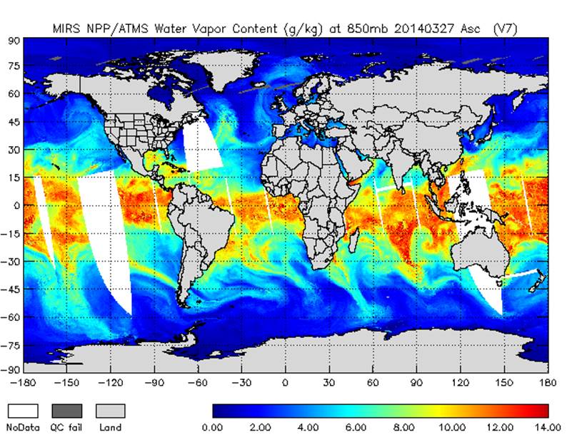 MIRS NPP/ATMS ascending water vapor profile at 850 mb on March 27, 2014. Image courtesy of NOAA OSPO.
This dataset contains temperature and humidity profiles from the NOAA Microwave Integrated Retrieval System (MIRS) using sensor data from the Advanced Technology Microwave Sounder (ATMS) onboard the Suomi National Polar-orbiting Partnership (S-NPP) satellite. ATMS is a cross-track scanner with 22 channels in spectral bands from 23 GHz through 183 GHz. MIRS was developed by the NOAA/NESDIS Center for Satellite Application and Research (STAR) and is produced operationally at the NOAA/NESDIS Office of Satellite and Product Operations (OSPO). The sounding (SND) products file contains temperature and water vapor profiles at 850, 900 and 950 millibars. Quality control metrics and flags defining retrieval product quality are also provided. Each product file encompasses one 32-second granule of data, corresponding to 4 scan lines of ATMS data. The products are distributed in netCDF-4 file format with metadata attributes included.
- Cite as: Liu, Quanhua, Zhao, Limin, Grassotti, Chris, and NOAA JPSS Program Office (2014): NOAA JPSS Microwave Integrated Retrieval System (MIRS) Advanced Technology Microwave Sounder (ATMS) Sounding Products from NDE. [indicate subset used]. NOAA National Centers for Environmental Information. doi:10.7289/V5X34VH3 [access date].
| Download Data |
-
NOAA CLASS FTP Server (download)
Access and download data tar files by date and product for the previous 85 days. The directory structure is as follows, date(yyyymmdd)->instrument family->product.
|
| Order Data |
|
| Distribution Formats |
|
| Ordering Instructions |
Contact NCEI for other distribution options and instructions. |
| Distributor |
NOAA National Centers for Environmental Information
ncei.info@noaa.gov
|
| Dataset Point of Contact |
DOC/NOAA/NESDIS/NCEI > National Centers for Environmental Information, NESDIS, NOAA, U.S. Department of Commerce
ncei.sat.info@noaa.gov
|
| Time Period |
2014-04-07 to Present |
| Spatial Reference System |
urn:ogc:def:crs:EPSG::4326 |
| Spatial Bounding Box Coordinates |
West: -180.0
East: 180.0
South: -90.0
North: 90.0
|
| Spatial Coverage Map |
|
| General Documentation |
|
| Processing Documents |
- JPSS STAR Science Documents
- JPSS STAR Algorithm Maturity Matrix
|
| Associated Resources |
- NOAA JPSS Microwave Integrated Retrieval System (MIRS) Advanced Technology Microwave Sounder (ATMS) Precipitation and Surface Products from NDE
- A physical approach for a simultaneous retrieval of sounding, surface, hydrometeor, and cryospheric parameters from SNPP/ATMS.
-
Journal article from November 2013 published by Wiley (Journal of Geophysical Research Atmosphere)
Boukabara, S., Garrett, K., Grassotti, C., et al., (2013), A physical approach for simultaneous retrieval of sounding, surface, hydrometeor, and cryospheric parameters from SNPP/ATMS, J. Geo. Res. Atm, 118(22), 12,600—12,619, doi:10.1002/2013JD020448
|
| Publication Dates |
|
| Edition |
Version 11 |
| Data Presentation Form |
Digital image
|
| Dataset Progress Status |
Ongoing - data is continually being updated |
| Data Update Frequency |
Continual |
| Purpose |
This dataset provides high quality measurements of temperature and humidity profiles products from ATMS. |
| Use Limitations |
- For a complete description of use limitations for this dataset, refer to the Algorithm Theoretical Basis Document.
|
| Dataset Citation |
- Cite as: Liu, Quanhua, Zhao, Limin, Grassotti, Chris, and NOAA JPSS Program Office (2014): NOAA JPSS Microwave Integrated Retrieval System (MIRS) Advanced Technology Microwave Sounder (ATMS) Sounding Products from NDE. [indicate subset used]. NOAA National Centers for Environmental Information. doi:10.7289/V5X34VH3 [access date].
|
| Cited Authors |
- Liu, Quanhua
DOC/NOAA/NESDIS/STAR > Center for Satellite Applications and Research, NESDIS, NOAA, U.S. Department of Commerce
- Zhao, Limin
DOC/NOAA/NESDIS/OSPO > Office of Satellite and Product Operations, NESDIS, NOAA, U.S. Department of Commerce
- Grassotti, Chris
DOC/NOAA/NESDIS/STAR > Center for Satellite Applications and Research, NESDIS, NOAA, U.S. Department of Commerce
- NOAA JPSS Program Office
|
| Originators |
|
| Principal Investigators |
- Liu, Quanhua
DOC/NOAA/NESDIS/STAR > Center for Satellite Applications and Research, NESDIS, NOAA, U.S. Department of Commerce
- Zhao, Limin
DOC/NOAA/NESDIS/OSPO > Office of Satellite and Product Operations, NESDIS, NOAA, U.S. Department of Commerce
|
| Collaborators |
- Grassotti, Chris
DOC/NOAA/NESDIS/STAR > Center for Satellite Applications and Research, NESDIS, NOAA, U.S. Department of Commerce
|
| Publishers |
- NOAA National Centers for Environmental Information
|
| Theme keywords |
Global Change Master Directory (GCMD) Science Keywords
- Earth Science > Atmosphere > Atmospheric Temperature > Upper Air Temperature
- Earth Science > Atmosphere > Atmospheric Water Vapor > Water Vapor Profiles
Global Climate Observing System (GCOS) Essential Climate Variables (ECVs)
- Atmospheric - Upper-air - Upper-air Temperature
- Atmospheric - Upper-air - Upper-air Water Vapour
|
| Data Center keywords |
Global Change Master Directory (GCMD) Data Center Keywords
- DOC/NOAA/NESDIS/NCDC > National Climatic Data Center, NESDIS, NOAA, U.S. Department of Commerce
- DOC/NOAA/NESDIS/NCEI > National Centers for Environmental Information, NESDIS, NOAA, U.S. Department of Commerce
- DOC/NOAA/NESDIS/STAR > Center for Satellite Applications and Research, NESDIS, NOAA, U.S. Department of Commerce
- DOC/NOAA/NESDIS/OSPO > Office of Satellite and Product Operations, NESDIS, NOAA, U.S. Department of Commerce
|
| Platform keywords |
Global Change Master Directory (GCMD) Platform Keywords- SUOMI-NPP > Suomi National Polar-orbiting Partnership
|
| Instrument keywords |
Global Change Master Directory (GCMD) Instrument Keywords- ATMS > Advanced Technology Microwave Sounder
|
| Place keywords |
Global Change Master Directory (GCMD) Location Keywords- Geographic Region > Global
|
| Project keywords |
Global Change Master Directory (GCMD) Project Keywords
- JPSS > Joint Polar Satellite System
- NOAA OneStop Project
- NDE > NESDIS Data Exploitation
|
| Data Resolution keywords |
Global Change Master Directory (GCMD) Horizontal Data Resolution Keywords- 10 km - < 50 km or approximately .09 degree - < .5 degree
|
| Stratum keywords |
Global Change Master Directory (GCMD) Location Keywords- Vertical Location > Troposphere
|
| Use Constraints |
- Cite as: Liu, Quanhua, Zhao, Limin, Grassotti, Chris, and NOAA JPSS Program Office (2014): NOAA JPSS Microwave Integrated Retrieval System (MIRS) Advanced Technology Microwave Sounder (ATMS) Sounding Products from NDE. [indicate subset used]. NOAA National Centers for Environmental Information. doi:10.7289/V5X34VH3 [access date].
- Use liability: NOAA and NCEI cannot provide any warranty as to the accuracy, reliability, or completeness of furnished data. Users assume responsibility to determine the usability of these data. The user is responsible for the results of any application of this data for other than its intended purpose.
|
| Access Constraints |
- Distribution liability: NOAA and NCEI make no warranty, expressed or implied, regarding these data, nor does the fact of distribution constitute such a warranty. NOAA and NCEI cannot assume liability for any damages caused by any errors or omissions in these data. If appropriate, NCEI can only certify that the data it distributes are an authentic copy of the records that were accepted for inclusion in the NCEI archives.
|
| Fees |
- In most cases, electronic downloads of the data are free. However, fees may apply for custom orders, data certifications, copies of analog materials, and data distribution on physical media.
|
| Lineage information for: dataset |
|---|
| Lineage Statement |
The data were produced by the NOAA Office of Satellite and Product Operations (OSPO) NDE/PDA and are archived at the NOAA National Centers for Environmental Information (NCEI). |
| Processor |
- DOC/NOAA/NESDIS/OSPO > Office of Satellite and Product Operations, NESDIS, NOAA, U.S. Department of Commerce
|
| Processing Steps |
- For a complete description of the processing steps, see the Algorithm Theoretical Basis Document and Data Flow Diagram.
- 2016-10-18T00:00:00Z - The MIRS algorithm reached validated maturity.
- 2014-08-28T00:00:00Z - The MIRS algorithm reached provisional maturity.
- 2012-04-19T00:00:00Z - The MIRS algorithm reached beta maturity.
|
| Processing Documents |
- JPSS STAR Science Documents
- JPSS STAR Algorithm Maturity Matrix
|
| Source Datasets |
- NOAA JPSS Advanced Technology Microwave Sounder (ATMS) Sensor Data Record (SDR) from IDPS
-
NCEI landing page for JPSS-ATMS-SDR
Source dataset landing page with general information and access links for the dataset.
- Description of Source: Sensor Data Record (SDR)
- Temporal extent used: 2012-04-19 to Present
- Spatial extent used: N:90 S:-90 E:180 W:-180
- NOAA JPSS Advanced Technology Microwave Sounder (ATMS) Temperature Data Record (TDR) from IDPS
-
NCEI landing page for JPSS-ATMS-TDR
Source dataset landing page with general information and access links for the dataset.
- Description of Source: Temperature Data Record (TDR)
- Temporal extent used: 2011-12-10 to Present
- Spatial extent used: N:90 S:-90 E:180 W:-180
|
| Lineage information for: repository |
|---|
| Processing Steps |
- 2015-04-22T00:00:00 - NOAA created the National Centers for Environmental Information (NCEI) by merging NOAA's National Climatic Data Center (NCDC), National Geophysical Data Center (NGDC), and National Oceanographic Data Center (NODC), including the National Coastal Data Development Center (NCDDC), per the Consolidated and Further Continuing Appropriations Act, 2015, Public Law 113-235. NCEI launched publicly on April 22, 2015.
|
Last Modified: 2023-06-23
For questions about the information on this page, please email:
ncei.info@noaa.gov