NOAA JPSS Visible Infrared Imaging Radiometer Suite (VIIRS) Daily Level-3 Polar Winds for the Southern Hemisphere and Northern Hemisphere from NDE
VIIRS-NVPWPS-NDE
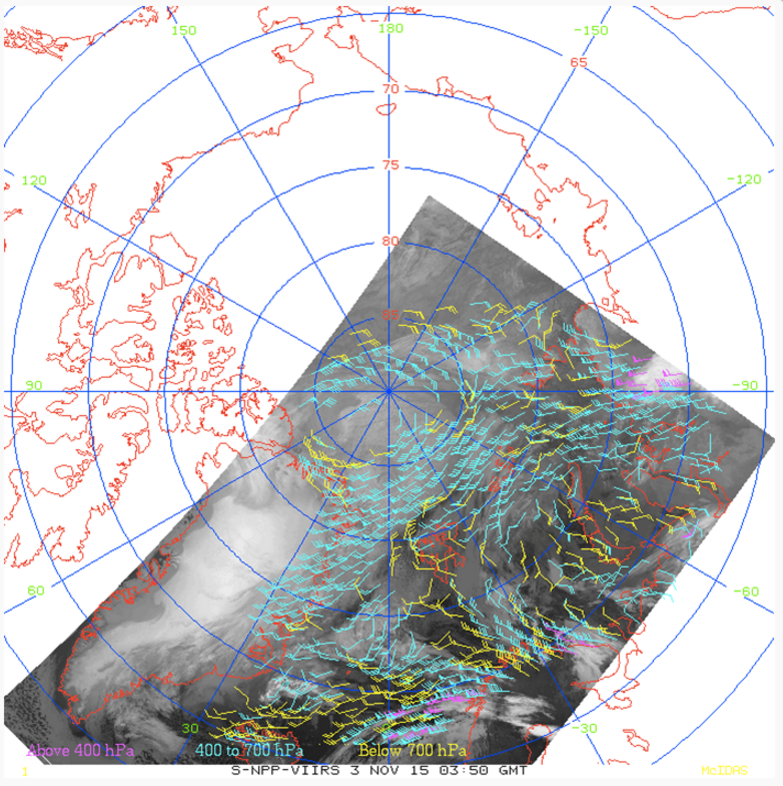 Example of Suomi NPP VIIRS polar winds over the Arctic from November 3, 2015. Image courtesy of JPSS LTM system.
This Level-3 (L3) Environmental Data Record (EDR) contains Polar Winds detected with the Visible Infrared Imaging Radiometer Suite (VIIRS) onboard the Suomi-NPP and NOAA-20 satellites. This product includes Northern Hemisphere and Southern Hemisphere grids, each extending poleward from 65 degrees. Tropospheric winds are measured by tracking the motion of cloud features in the overlapping region of three successive orbits. A triplet of images is used to facilitate consistency checking and quality control. Wind products include wind speed, direction, and height at high latitudes. This daily product is produced by the NOAA Environmental Satellite, Data, and Information Service (NESDIS) and is distributed by the Comprehensive Large Array-Data Stewardship System (CLASS) in the NetCDF-4 file format with metadata attributes included.
- Cite as: Key, Jeffrey, Daniels, Jaime, Qi, Hongming, and NOAA JPSS Program Office (2014): NOAA JPSS Visible Infrared Imaging Radiometer Suite (VIIRS) Polar Winds from NDE. [indicate subset used]. NOAA National Centers for Environmental Information. doi:10.7289/V5JD4TVV. [access date].
| Download Data |
-
NOAA CLASS FTP Server (download)
Access and download data tar files by date and product for the previous 85 days. The directory structure is as follows, date(yyyymmdd)->instrument family->product.
|
| Order Data |
|
| Distribution Formats |
|
| Ordering Instructions |
Contact NCEI for other distribution options and instructions. |
| Distributor |
NOAA National Centers for Environmental Information
ncei.info@noaa.gov
|
| Dataset Point of Contact |
DOC/NOAA/NESDIS/NCEI > National Centers for Environmental Information, NESDIS, NOAA, U.S. Department of Commerce
ncei.sat.info@noaa.gov
|
| Time Period |
2014-04-07 to Present (time interval: 101-minute) |
| Spatial Reference System |
urn:ogc:def:crs:EPSG::4326 |
| Spatial Bounding Box Coordinates |
West: -180.0
East: 180.0
South: -90.0
North: 90.0
|
| Spatial Coverage Map |
|
| General Documentation |
|
| Processing Documents |
- JPSS STAR Science Documents
|
| Associated Resources |
- VIIRS Polar winds status and use
-
Conference paper presented June 2014 at the Twelth International Winds Workshop at Copenhagen, Denmark
Key, J., Daniels, J., et al., (2014), VIIRS Polar winds status and use, paper presented at the Twelfth International Winds Workshop, Copenhagen, Denmark
|
| Publication Dates |
|
| Edition |
Version 1 |
| Data Presentation Form |
Digital image
|
| Dataset Progress Status |
Ongoing - data is continually being updated |
| Data Update Frequency |
Continual |
| Purpose |
This dataset provides high quality measurements of tropospheric winds from VIIRS. |
| Use Limitations |
- For a complete description of use limitations for this dataset, refer to the Algorithm Theoretical Basis Document.
|
| Dataset Citation |
- Cite as: Key, Jeffrey, Daniels, Jaime, Qi, Hongming, and NOAA JPSS Program Office (2014): NOAA JPSS Visible Infrared Imaging Radiometer Suite (VIIRS) Polar Winds from NDE. [indicate subset used]. NOAA National Centers for Environmental Information. doi:10.7289/V5JD4TVV. [access date].
|
| Cited Authors |
- Daniels, Jaime
DOC/NOAA/NESDIS/STAR > Center for Satellite Applications and Research, NESDIS, NOAA, U.S. Department of Commerce
- Key, Jeffrey
DOC/NOAA/NESDIS/STAR > Center for Satellite Applications and Research, NESDIS, NOAA, U.S. Department of Commerce
- Qi, Hongming
DOC/NOAA/NESDIS/OSPO > Office of Satellite Products and Operations, NESDIS, NOAA, U.S. Department of Commerce
- NOAA JPSS Program Office
- NOAA Office of Satellite and Product Operations
|
| Originators |
- NOAA JPSS Program Office
- NOAA Office of Satellite and Product Operations
|
| Principal Investigators |
- Daniels, Jaime
DOC/NOAA/NESDIS/STAR > Center for Satellite Applications and Research, NESDIS, NOAA, U.S. Department of Commerce
- Key, Jeffrey
DOC/NOAA/NESDIS/STAR > Center for Satellite Applications and Research, NESDIS, NOAA, U.S. Department of Commerce
- Qi, Hongming
DOC/NOAA/NESDIS/OSPO > Office of Satellite Products and Operations, NESDIS, NOAA, U.S. Department of Commerce
|
| Publishers |
- NOAA National Centers for Environmental Information
|
| Theme keywords |
Global Change Master Directory (GCMD) Science Keywords
- Earth Science > Atmosphere > Atmospheric Winds > Upper Level Winds > Wind Speed/Wind Direction
- Earth Science > Atmosphere > Atmospheric Winds > Boundary Layer Winds
- Earth Science > Atmosphere > Atmospheric Winds > Surface Winds
- Earth Science > Atmosphere > Atmospheric Winds > Upper Level Winds > Flight Level Winds
Global Climate Observing System (GCOS) Essential Climate Variables (ECVs)- Atmospheric - Upper-air - Upper-air Wind Speed And Direction
|
| Data Center keywords |
Global Change Master Directory (GCMD) Data Center Keywords
- DOC/NOAA/NESDIS/NCDC > National Climatic Data Center, NESDIS, NOAA, U.S. Department of Commerce
- DOC/NOAA/NESDIS/NCEI > National Centers for Environmental Information, NESDIS, NOAA, U.S. Department of Commerce
- DOC/NOAA/NESDIS/STAR > Center for Satellite Applications and Research, NESDIS, NOAA, U.S. Department of Commerce
- DOC/NOAA/NESDIS/OSPO > Office of Satellite and Product Operations, NESDIS, NOAA, U.S. Department of Commerce
|
| Platform keywords |
Global Change Master Directory (GCMD) Platform Keywords- SUOMI-NPP > Suomi National Polar-orbiting Partnership
|
| Instrument keywords |
Global Change Master Directory (GCMD) Instrument Keywords- VIIRS > Visible-Infrared Imager-Radiometer Suite
|
| Place keywords |
Global Change Master Directory (GCMD) Location Keywords
- Geographic Region > Polar
- Continent > Antarctica
- Geographic Region > Arctic
- Ocean > Arctic Ocean
- Ocean > Southern Ocean
- Continent > North America > Greenland
- Continent > Europe > Northern Europe > Iceland
- Continent > Europe > Northern Europe > Scandinavia > Norway
- Continent > Europe > Northern Europe > Scandinavia > Sweden
- Continent > Europe > Northern Europe > Scandinavia > Finland
- Continent > North America > United States Of America > Alaska
- Continent > Europe > Eastern Europe > Russian Federation
- Ocean > Arctic Ocean > Beaufort Sea
- Ocean > Arctic Ocean > Chukchi Sea
- Ocean > Arctic Ocean > Barents Sea
- Ocean > Atlantic Ocean > North Atlantic Ocean > Norwegian Sea
- Continent > North America > Canada > Nunavut
- Continent > North America > Canada > Yukon Territory
- Continent > North America > Canada > Northwest Territories
- Continent > North America > Canada > Manitoba
|
| Project keywords |
Global Change Master Directory (GCMD) Project Keywords
- JPSS > Joint Polar Satellite System
- NOAA OneStop Project
- NDE > NESDIS Data Exploitation
|
| Data Resolution keywords |
Global Change Master Directory (GCMD) Horizontal Data Resolution Keywords- 10 km - < 50 km or approximately .09 degree - < .5 degree
|
| Stratum keywords |
Global Change Master Directory (GCMD) Location Keywords
- Vertical Location > Troposphere
- Vertical Location > Boundary Layer
- Vertical Location > Sea Surface
- Vertical Location > Land Surface
|
| Use Constraints |
- Cite as: Key, Jeffrey, Daniels, Jaime, Qi, Hongming, and NOAA JPSS Program Office (2014): NOAA JPSS Visible Infrared Imaging Radiometer Suite (VIIRS) Polar Winds from NDE. [indicate subset used]. NOAA National Centers for Environmental Information. doi:10.7289/V5JD4TVV. [access date].
- Use liability: NOAA and NCEI cannot provide any warranty as to the accuracy, reliability, or completeness of furnished data. Users assume responsibility to determine the usability of these data. The user is responsible for the results of any application of this data for other than its intended purpose.
|
| Access Constraints |
- Distribution liability: NOAA and NCEI make no warranty, expressed or implied, regarding these data, nor does the fact of distribution constitute such a warranty. NOAA and NCEI cannot assume liability for any damages caused by any errors or omissions in these data. If appropriate, NCEI can only certify that the data it distributes are an authentic copy of the records that were accepted for inclusion in the NCEI archives.
|
| Fees |
- In most cases, electronic downloads of the data are free. However, fees may apply for custom orders, data certifications, copies of analog materials, and data distribution on physical media.
|
| Lineage information for: dataset |
|---|
| Lineage Statement |
The data were produced by the NOAA Office of Satellite and Product Operations (OSPO) NDE/PDA and are archived at the NOAA National Centers for Environmental Information (NCEI). |
| Processing Steps |
- For a complete description of the processing steps, see the Algorithm Theoretical Basis Document and Data Flow Diagram.
- 2014-03-27T00:00:00 - The S-NPP VIIRS Polar Winds algorithm reached provisional maturity status.
- 2016-10-18T00:00:00 - The S-NPP VIIRS Polar Winds algorithm reached validated maturity status.
- 2018-10-02T00:00:00 - The NOAA-20 VIIRS Polar Winds algorithm reached beta maturity status.
- 2018-10-02T00:00:00 - The NOAA-20 VIIRS Polar Winds algorithm reached provisional maturity status.
- 2019-05-29T00:00:00 - The NOAA-20 VIIRS Polar Winds algorithm reached validated maturity status.
|
| Processing Documents |
- JPSS STAR Science Documents
|
| Source Datasets |
- NOAA JPSS Visible Infrared Imaging Radiometer Suite (VIIRS) Sensor Data Record (SDR) from IDPS
-
NCEI landing page for JPSS-VIIRS-SDR
Source dataset landing page with general information and access links for the dataset.
- Description of Source: VIIRS Sensor Data Record (SDR)
- Temporal extent used: 2012-02-07 to Present
- Temporal extent used: 2012-02-07 to Present
- Spatial extent used: N:90 S:65 E:180 W:-180
|
| Lineage information for: repository |
|---|
| Processing Steps |
- 2015-04-22T00:00:00 - NOAA created the National Centers for Environmental Information (NCEI) by merging NOAA's National Climatic Data Center (NCDC), National Geophysical Data Center (NGDC), and National Oceanographic Data Center (NODC), including the National Coastal Data Development Center (NCDDC), per the Consolidated and Further Continuing Appropriations Act, 2015, Public Law 113-235. NCEI launched publicly on April 22, 2015.
|
Last Modified: 2023-06-23
For questions about the information on this page, please email:
ncei.info@noaa.gov