NOAA JPSS Visible Infrared Imaging Radiometer Suite (VIIRS) Daily Level-3 Polar Winds for the Southern Hemisphere and Northern Hemisphere from NDE
- referenceSystemInfo
- identificationInfo
- contentInfo
- distributionInfo
- dataQualityInfo
- dataQualityInfo
- dataQualityInfo
- metadataMaintenance
(MI_Metadata)
fileIdentifier: gov.noaa.ncdc:C00869
language: eng; USA
characterSet: (MD_CharacterSetCode) utf8
hierarchyLevel: (MD_ScopeCode) dataset
contact: (CI_ResponsibleParty)
organisationName: NOAA National Centers for Environmental Information
contactInfo: (CI_Contact)
address: (CI_Address)
electronicMailAddress: ncei.info@noaa.gov
onlineResource: (CI_OnlineResource)
linkage: https://www.ncei.noaa.gov/contact
name: NCEI Contact Information
description: Information for contacts at NCEI.
function: (CI_OnLineFunctionCode) information
role: (CI_RoleCode) pointOfContact
dateStamp: 2023-06-23
metadataStandardName: ISO 19115-2 Geographic Information - Metadata - Part 2: Extensions for Imagery and Gridded Data
metadataStandardVersion: ISO 19115-2:2009(E)
return to top
referenceSystemInfo: (MD_ReferenceSystem)
referenceSystemIdentifier: (RS_Identifier)
authority: (CI_Citation)
title: EPSG Geodetic Parameter Dataset Registry
date: (CI_Date)
date: 2008-11-12
dateType: (CI_DateTypeCode) publication
citedResponsibleParty: (CI_ResponsibleParty)
organisationName: International Association of Oil and Gas Producers (OGP) Geomatics Committee
contactInfo: (CI_Contact)
onlineResource: (CI_OnlineResource)
linkage: http://www.epsg-registry.org/
applicationProfile: Data Search Application
name: EPSG Geodetic Parameter Dataset Registry Application
description: Interface to the EPSG Geodetic Parameter Dataset Registry
function: (CI_OnLineFunctionCode) search
role: (CI_RoleCode) custodian
citedResponsibleParty: (CI_ResponsibleParty)
organisationName: International Association of Oil and Gas Producers (OGP) Geomatics Committee
contactInfo: (CI_Contact)
onlineResource: (CI_OnlineResource)
linkage: http://www.epsg-registry.org/export.htm?gml=urn:ogc:def:crs:EPSG::4326
applicationProfile: Download
name: Coordinate Reference System data in GML
description: Coordinate Reference System data in GML
function: (CI_OnLineFunctionCode) download
role: (CI_RoleCode) custodian
code: urn:ogc:def:crs:EPSG::4326
version: (unknown)
return to top
identificationInfo: (MD_DataIdentification)
citation: (CI_Citation)
title: NOAA JPSS Visible Infrared Imaging Radiometer Suite (VIIRS) Daily Level-3 Polar Winds for the Southern Hemisphere and Northern Hemisphere from NDE
alternateTitle: VIIRS-NVPWPS-NDE
date: (CI_Date)
date: 2014-04-07
dateType: (CI_DateTypeCode) publication
edition: Version 1
identifier: (MD_Identifier)
code:
Anchor: DOI doi:10.7289/V5JD4TVV
identifier: (MD_Identifier)
code: gov.noaa.ncdc:C00869
identifier: (MD_Identifier)
code: gov.noaa.class:POLWINSH
identifier: (MD_Identifier)
code: gov.noaa.class:JPSS_NGRN
citedResponsibleParty: (CI_ResponsibleParty)
organisationName: NOAA National Centers for Environmental Information
role: (CI_RoleCode) publisher
citedResponsibleParty: (CI_ResponsibleParty)
individualName: Daniels, Jaime
organisationName: DOC/NOAA/NESDIS/STAR > Center for Satellite Applications and Research, NESDIS, NOAA, U.S. Department of Commerce
role: (CI_RoleCode) principalInvestigator
citedResponsibleParty: (CI_ResponsibleParty)
individualName: Daniels, Jaime
organisationName: DOC/NOAA/NESDIS/STAR > Center for Satellite Applications and Research, NESDIS, NOAA, U.S. Department of Commerce
role: (CI_RoleCode) author
citedResponsibleParty: (CI_ResponsibleParty)
individualName: Key, Jeffrey
organisationName: DOC/NOAA/NESDIS/STAR > Center for Satellite Applications and Research, NESDIS, NOAA, U.S. Department of Commerce
role: (CI_RoleCode) principalInvestigator
citedResponsibleParty: (CI_ResponsibleParty)
individualName: Key, Jeffrey
organisationName: DOC/NOAA/NESDIS/STAR > Center for Satellite Applications and Research, NESDIS, NOAA, U.S. Department of Commerce
role: (CI_RoleCode) author
citedResponsibleParty: (CI_ResponsibleParty)
individualName: Qi, Hongming
organisationName: DOC/NOAA/NESDIS/OSPO > Office of Satellite Products and Operations, NESDIS, NOAA, U.S. Department of Commerce
role: (CI_RoleCode) principalInvestigator
citedResponsibleParty: (CI_ResponsibleParty)
individualName: Qi, Hongming
organisationName: DOC/NOAA/NESDIS/OSPO > Office of Satellite Products and Operations, NESDIS, NOAA, U.S. Department of Commerce
role: (CI_RoleCode) author
citedResponsibleParty: (CI_ResponsibleParty)
organisationName: NOAA JPSS Program Office
role: (CI_RoleCode) originator
citedResponsibleParty: (CI_ResponsibleParty)
organisationName: NOAA JPSS Program Office
role: (CI_RoleCode) author
citedResponsibleParty: (CI_ResponsibleParty)
organisationName: NOAA Office of Satellite and Product Operations
role: (CI_RoleCode) originator
citedResponsibleParty: (CI_ResponsibleParty)
organisationName: NOAA Office of Satellite and Product Operations
role: (CI_RoleCode) author
presentationForm: (CI_PresentationFormCode) imageDigital
abstract: This Level-3 (L3) Environmental Data Record (EDR) contains Polar Winds detected with the Visible Infrared Imaging Radiometer Suite (VIIRS) onboard the Suomi-NPP and NOAA-20 satellites. This product includes Northern Hemisphere and Southern Hemisphere grids, each extending poleward from 65 degrees. Tropospheric winds are measured by tracking the motion of cloud features in the overlapping region of three successive orbits. A triplet of images is used to facilitate consistency checking and quality control. Wind products include wind speed, direction, and height at high latitudes. This daily product is produced by the NOAA Environmental Satellite, Data, and Information Service (NESDIS) and is distributed by the Comprehensive Large Array-Data Stewardship System (CLASS) in the NetCDF-4 file format with metadata attributes included.
purpose: This dataset provides high quality measurements of tropospheric winds from VIIRS.
status: (MD_ProgressCode) onGoing
pointOfContact: (CI_ResponsibleParty)
organisationName: DOC/NOAA/NESDIS/NCEI > National Centers for Environmental Information, NESDIS, NOAA, U.S. Department of Commerce
contactInfo: (CI_Contact)
address: (CI_Address)
electronicMailAddress: ncei.sat.info@noaa.gov
role: (CI_RoleCode) pointOfContact
resourceMaintenance: (MD_MaintenanceInformation)
maintenanceAndUpdateFrequency: (MD_MaintenanceFrequencyCode) continual
graphicOverview: (MD_BrowseGraphic)
fileName: https://www.ncei.noaa.gov/pub/data/metadata/images/C00869.PNG
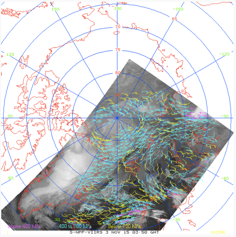
fileDescription: Example of Suomi NPP VIIRS polar winds over the Arctic from November 3, 2015. Image courtesy of JPSS LTM system.
fileType: PNG
descriptiveKeywords: (MD_Keywords)
keyword: Earth Science > Atmosphere > Atmospheric Winds > Upper Level Winds > Wind Speed/Wind Direction
keyword: Earth Science > Atmosphere > Atmospheric Winds > Boundary Layer Winds
keyword: Earth Science > Atmosphere > Atmospheric Winds > Surface Winds
keyword: Earth Science > Atmosphere > Atmospheric Winds > Upper Level Winds > Flight Level Winds
type: (MD_KeywordTypeCode) theme
thesaurusName: (CI_Citation)
title: Global Change Master Directory (GCMD) Science Keywords
date: (CI_Date)
date: 2018
dateType: (CI_DateTypeCode) revision
edition: Version 8.6
citedResponsibleParty: (CI_ResponsibleParty)
organisationName: Global Change Data Center, Science and Exploration Directorate, Goddard Space Flight Center (GSFC) National Aeronautics and Space Administration (NASA)
contactInfo: (CI_Contact)
onlineResource: (CI_OnlineResource)
linkage: https://earthdata.nasa.gov/about/gcmd/global-change-master-directory-gcmd-keywords
protocol: HTTPS
applicationProfile: Web Browser
name: Global Change Master Directory (GCMD) Keywords
description: The information provided on this page seeks to define how the GCMD Keywords are structured, used and accessed. It also provides information on how users can participate in the further development of the keywords.
function: (CI_OnLineFunctionCode) information
role: (CI_RoleCode) publisher
descriptiveKeywords: (MD_Keywords)
keyword: Atmospheric - Upper-air - Upper-air Wind Speed And Direction
type: (MD_KeywordTypeCode) theme
thesaurusName: (CI_Citation)
title: Global Climate Observing System (GCOS) Essential Climate Variables (ECVs)
date: (CI_Date)
date: 2017
dateType: (CI_DateTypeCode) publication
edition: Release 2017
citedResponsibleParty: (CI_ResponsibleParty)
organisationName: World Meteorological Organization, United Nations
contactInfo: (CI_Contact)
onlineResource: (CI_OnlineResource)
linkage: https://public.wmo.int/en/programmes/global-climate-observing-system/essential-climate-variables
protocol: HTTP
applicationProfile: Information
name: GCOS Essential Climate Variables
description: Overview of the GCOS Essential Climate Variables.
function: (CI_OnLineFunctionCode) information
role: (CI_RoleCode) custodian
descriptiveKeywords: (MD_Keywords)
keyword: Geographic Region > Polar
keyword: Continent > Antarctica
keyword: Geographic Region > Arctic
keyword: Ocean > Arctic Ocean
keyword: Ocean > Southern Ocean
keyword: Continent > North America > Greenland
keyword: Continent > Europe > Northern Europe > Iceland
keyword: Continent > Europe > Northern Europe > Scandinavia > Norway
keyword: Continent > Europe > Northern Europe > Scandinavia > Sweden
keyword: Continent > Europe > Northern Europe > Scandinavia > Finland
keyword: Continent > North America > United States Of America > Alaska
keyword: Continent > Europe > Eastern Europe > Russian Federation
keyword: Ocean > Arctic Ocean > Beaufort Sea
keyword: Ocean > Arctic Ocean > Chukchi Sea
keyword: Ocean > Arctic Ocean > Barents Sea
keyword: Ocean > Atlantic Ocean > North Atlantic Ocean > Norwegian Sea
keyword: Continent > North America > Canada > Nunavut
keyword: Continent > North America > Canada > Yukon Territory
keyword: Continent > North America > Canada > Northwest Territories
keyword: Continent > North America > Canada > Manitoba
type: (MD_KeywordTypeCode) place
thesaurusName: (CI_Citation)
title: Global Change Master Directory (GCMD) Location Keywords
date: (CI_Date)
date: 2018
dateType: (CI_DateTypeCode) revision
edition: Version 8.6
citedResponsibleParty: (CI_ResponsibleParty)
organisationName: Global Change Data Center, Science and Exploration Directorate, Goddard Space Flight Center (GSFC) National Aeronautics and Space Administration (NASA)
contactInfo: (CI_Contact)
onlineResource: (CI_OnlineResource)
linkage: https://earthdata.nasa.gov/about/gcmd/global-change-master-directory-gcmd-keywords
protocol: HTTPS
applicationProfile: Web Browser
name: Global Change Master Directory (GCMD) Keywords
description: The information provided on this page seeks to define how the GCMD Keywords are structured, used and accessed. It also provides information on how users can participate in the further development of the keywords.
function: (CI_OnLineFunctionCode) information
role: (CI_RoleCode) publisher
descriptiveKeywords: (MD_Keywords)
keyword: Vertical Location > Troposphere
keyword: Vertical Location > Boundary Layer
keyword: Vertical Location > Sea Surface
keyword: Vertical Location > Land Surface
type: (MD_KeywordTypeCode) stratum
thesaurusName: (CI_Citation)
title: Global Change Master Directory (GCMD) Location Keywords
date: (CI_Date)
date: 2018
dateType: (CI_DateTypeCode) revision
edition: Version 8.6
citedResponsibleParty: (CI_ResponsibleParty)
organisationName: Global Change Data Center, Science and Exploration Directorate, Goddard Space Flight Center (GSFC) National Aeronautics and Space Administration (NASA)
contactInfo: (CI_Contact)
onlineResource: (CI_OnlineResource)
linkage: https://earthdata.nasa.gov/about/gcmd/global-change-master-directory-gcmd-keywords
protocol: HTTPS
applicationProfile: Web Browser
name: Global Change Master Directory (GCMD) Keywords
description: The information provided on this page seeks to define how the GCMD Keywords are structured, used and accessed. It also provides information on how users can participate in the further development of the keywords.
function: (CI_OnLineFunctionCode) information
role: (CI_RoleCode) publisher
descriptiveKeywords: (MD_Keywords)
keyword: JPSS > Joint Polar Satellite System
keyword: NOAA OneStop Project
type: (MD_KeywordTypeCode) project
thesaurusName: (CI_Citation)
title: Global Change Master Directory (GCMD) Project Keywords
date: (CI_Date)
date: 2018
dateType: (CI_DateTypeCode) revision
edition: Version 8.6
citedResponsibleParty: (CI_ResponsibleParty)
organisationName: Global Change Data Center, Science and Exploration Directorate, Goddard Space Flight Center (GSFC) National Aeronautics and Space Administration (NASA)
contactInfo: (CI_Contact)
onlineResource: (CI_OnlineResource)
linkage: https://earthdata.nasa.gov/about/gcmd/global-change-master-directory-gcmd-keywords
protocol: HTTPS
applicationProfile: Web Browser
name: Global Change Master Directory (GCMD) Keywords
description: The information provided on this page seeks to define how the GCMD Keywords are structured, used and accessed. It also provides information on how users can participate in the further development of the keywords.
function: (CI_OnLineFunctionCode) information
role: (CI_RoleCode) publisher
descriptiveKeywords: (MD_Keywords)
keyword: VIIRS > Visible-Infrared Imager-Radiometer Suite
type: (MD_KeywordTypeCode) instrument
thesaurusName: (CI_Citation)
title: Global Change Master Directory (GCMD) Instrument Keywords
date: (CI_Date)
date: 2018
dateType: (CI_DateTypeCode) revision
edition: Version 8.6
citedResponsibleParty: (CI_ResponsibleParty)
organisationName: Global Change Data Center, Science and Exploration Directorate, Goddard Space Flight Center (GSFC) National Aeronautics and Space Administration (NASA)
contactInfo: (CI_Contact)
onlineResource: (CI_OnlineResource)
linkage: https://earthdata.nasa.gov/about/gcmd/global-change-master-directory-gcmd-keywords
protocol: HTTPS
applicationProfile: Web Browser
name: Global Change Master Directory (GCMD) Keywords
description: The information provided on this page seeks to define how the GCMD Keywords are structured, used and accessed. It also provides information on how users can participate in the further development of the keywords.
function: (CI_OnLineFunctionCode) information
role: (CI_RoleCode) publisher
descriptiveKeywords: (MD_Keywords)
keyword: SUOMI-NPP > Suomi National Polar-orbiting Partnership
type: (MD_KeywordTypeCode) platform
thesaurusName: (CI_Citation)
title: Global Change Master Directory (GCMD) Platform Keywords
date: (CI_Date)
date: 2018
dateType: (CI_DateTypeCode) revision
edition: Version 8.6
citedResponsibleParty: (CI_ResponsibleParty)
organisationName: Global Change Data Center, Science and Exploration Directorate, Goddard Space Flight Center (GSFC) National Aeronautics and Space Administration (NASA)
contactInfo: (CI_Contact)
onlineResource: (CI_OnlineResource)
linkage: https://earthdata.nasa.gov/about/gcmd/global-change-master-directory-gcmd-keywords
protocol: HTTPS
applicationProfile: Web Browser
name: Global Change Master Directory (GCMD) Keywords
description: The information provided on this page seeks to define how the GCMD Keywords are structured, used and accessed. It also provides information on how users can participate in the further development of the keywords.
function: (CI_OnLineFunctionCode) information
role: (CI_RoleCode) publisher
descriptiveKeywords: (MD_Keywords)
keyword: 10 km - < 50 km or approximately .09 degree - < .5 degree
type: (MD_KeywordTypeCode) dataResolution
thesaurusName: (CI_Citation)
title: Global Change Master Directory (GCMD) Horizontal Data Resolution Keywords
date: (CI_Date)
date: 2018
dateType: (CI_DateTypeCode) revision
edition: Version 8.6
citedResponsibleParty: (CI_ResponsibleParty)
organisationName: Global Change Data Center, Science and Exploration Directorate, Goddard Space Flight Center (GSFC) National Aeronautics and Space Administration (NASA)
contactInfo: (CI_Contact)
onlineResource: (CI_OnlineResource)
linkage: https://earthdata.nasa.gov/about/gcmd/global-change-master-directory-gcmd-keywords
protocol: HTTPS
applicationProfile: Web Browser
name: Global Change Master Directory (GCMD) Keywords
description: The information provided on this page seeks to define how the GCMD Keywords are structured, used and accessed. It also provides information on how users can participate in the further development of the keywords.
function: (CI_OnLineFunctionCode) information
role: (CI_RoleCode) publisher
descriptiveKeywords: (MD_Keywords)
keyword: DOC/NOAA/NESDIS/NCDC > National Climatic Data Center, NESDIS, NOAA, U.S. Department of Commerce
keyword: DOC/NOAA/NESDIS/NCEI > National Centers for Environmental Information, NESDIS, NOAA, U.S. Department of Commerce
keyword: DOC/NOAA/NESDIS/STAR > Center for Satellite Applications and Research, NESDIS, NOAA, U.S. Department of Commerce
keyword: DOC/NOAA/NESDIS/OSPO > Office of Satellite and Product Operations, NESDIS, NOAA, U.S. Department of Commerce
type: (MD_KeywordTypeCode) dataCentre
thesaurusName: (CI_Citation)
title: Global Change Master Directory (GCMD) Data Center Keywords
date: (CI_Date)
date: 2018
dateType: (CI_DateTypeCode) revision
edition: Version 8.6
citedResponsibleParty: (CI_ResponsibleParty)
organisationName: Global Change Data Center, Science and Exploration Directorate, Goddard Space Flight Center (GSFC) National Aeronautics and Space Administration (NASA)
contactInfo: (CI_Contact)
onlineResource: (CI_OnlineResource)
linkage: https://earthdata.nasa.gov/about/gcmd/global-change-master-directory-gcmd-keywords
protocol: HTTPS
applicationProfile: Web Browser
name: Global Change Master Directory (GCMD) Keywords
description: The information provided on this page seeks to define how the GCMD Keywords are structured, used and accessed. It also provides information on how users can participate in the further development of the keywords.
function: (CI_OnLineFunctionCode) information
role: (CI_RoleCode) publisher
descriptiveKeywords: (MD_Keywords)
keyword: NDE > NESDIS Data Exploitation
type: (MD_KeywordTypeCode) project
descriptiveKeywords: (MD_Keywords)
keyword: gov.noaa.class:JPSS_NGRN
type: (MD_KeywordTypeCode) other
resourceConstraints: (MD_Constraints)
useLimitation: For a complete description of use limitations for this dataset, refer to the Algorithm Theoretical Basis Document.
resourceConstraints: (MD_LegalConstraints)
useConstraints: (MD_RestrictionCode) otherRestrictions
otherConstraints: Cite as: Key, Jeffrey, Daniels, Jaime, Qi, Hongming, and NOAA JPSS Program Office (2014): NOAA JPSS Visible Infrared Imaging Radiometer Suite (VIIRS) Polar Winds from NDE. [indicate subset used]. NOAA National Centers for Environmental Information. doi:10.7289/V5JD4TVV. [access date].
resourceConstraints: (MD_LegalConstraints)
accessConstraints: (MD_RestrictionCode) otherRestrictions
otherConstraints: Distribution liability: NOAA and NCEI make no warranty, expressed or implied, regarding these data, nor does the fact of distribution constitute such a warranty. NOAA and NCEI cannot assume liability for any damages caused by any errors or omissions in these data. If appropriate, NCEI can only certify that the data it distributes are an authentic copy of the records that were accepted for inclusion in the NCEI archives.
resourceConstraints: (MD_LegalConstraints)
useConstraints: (MD_RestrictionCode) otherRestrictions
otherConstraints: Use liability: NOAA and NCEI cannot provide any warranty as to the accuracy, reliability, or completeness of furnished data. Users assume responsibility to determine the usability of these data. The user is responsible for the results of any application of this data for other than its intended purpose.
aggregationInfo: (MD_AggregateInformation)
aggregateDataSetName: (CI_Citation)
title: VIIRS Polar winds status and use
date: (CI_Date)
date: 2014-06-16
dateType: (CI_DateTypeCode) publication
citedResponsibleParty: (CI_ResponsibleParty)
organisationName: International Winds Workshop
role: (CI_RoleCode) publisher
citedResponsibleParty: (CI_ResponsibleParty)
organisationName: (missing)
contactInfo: (CI_Contact)
onlineResource: (CI_OnlineResource)
linkage: https://www.researchgate.net/publication/274567733_VIIRS_Polar_winds_status_and_use
protocol: HTTPS
applicationProfile: Web Browser
name: Conference paper presented June 2014 at the Twelth International Winds Workshop at Copenhagen, Denmark
description: Key, J., Daniels, J., et al., (2014), VIIRS Polar winds status and use, paper presented at the Twelfth International Winds Workshop, Copenhagen, Denmark
function: (CI_OnLineFunctionCode) information
role: (missing)
associationType: (DS_AssociationTypeCode) crossReference
initiativeType: (DS_InitiativeTypeCode) sciencePaper
spatialRepresentationType: (MD_SpatialRepresentationTypeCode) grid
spatialResolution: (MD_Resolution)
distance:
Distance: 19000
language: eng; USA
topicCategory: (MD_TopicCategoryCode) climatologyMeteorologyAtmosphere
extent: (EX_Extent)
geographicElement: (EX_GeographicBoundingBox)
extentTypeCode: 1
westBoundLongitude: -180.0
eastBoundLongitude: 180.0
southBoundLatitude: -90.0
northBoundLatitude: 90.0
temporalElement: (EX_TemporalExtent)
extent:
TimePeriod:
description: ground condition
beginPosition: 2014-04-07
endPosition:
timeInterval: 101
return to top
contentInfo: (MI_CoverageDescription)
attributeDescription:
RecordType: PAMV-VIIRS-CD-SH_v1r1_npp_sYYYYMMDDHHMMSSS_eYYYYMMDDHHMMSSS_cYYYYMMDDHHMMSSS.nc
contentType: (MD_CoverageContentTypeCode) physicalMeasurement
dimension: (MD_Band)
sequenceIdentifier:
MemberName:
aName: Time
attributeType:
TypeName:
aName: int
descriptor: date/time of measurement
units: http://example.org/someUnitsDictionary.xml#secs%20since%201970-01-01%2000%3A00%3A00
dimension: (MD_Band)
sequenceIdentifier:
MemberName:
aName: Latitude
attributeType:
TypeName:
aName: float
descriptor: Wind Latitude
units: http://example.org/someUnitsDictionary.xml#degrees_north
dimension: (MD_Band)
sequenceIdentifier:
MemberName:
aName: Longitude
attributeType:
TypeName:
aName: float
descriptor: Wind Longitude
units: http://example.org/someUnitsDictionary.xml#degrees_east
dimension: (MD_Band)
sequenceIdentifier:
MemberName:
aName: Wind_Speed
attributeType:
TypeName:
aName: float
descriptor: Speed of average wind vector (m/s)
units: http://example.org/someUnitsDictionary.xml#m.s-1
dimension: (MD_Band)
sequenceIdentifier:
MemberName:
aName: Wind_Dir
attributeType:
TypeName:
aName: float
descriptor: Direction of average wind vector (degrees)
units: http://example.org/someUnitsDictionary.xml#degree
dimension: (MD_Band)
sequenceIdentifier:
MemberName:
aName: UComponent1
attributeType:
TypeName:
aName: float
descriptor: u-component of first (reverse time) vector
units: http://example.org/someUnitsDictionary.xml#m.s-1
dimension: (MD_Band)
sequenceIdentifier:
MemberName:
aName: VComponent1
attributeType:
TypeName:
aName: float
descriptor: v-component of first (reverse time) vector
units: http://example.org/someUnitsDictionary.xml#m.s-1
dimension: (MD_Band)
sequenceIdentifier:
MemberName:
aName: UComponent2
attributeType:
TypeName:
aName: float
descriptor: u-component of second (forward) vector
units: http://example.org/someUnitsDictionary.xml#m.s-1
dimension: (MD_Band)
sequenceIdentifier:
MemberName:
aName: VComponent2
attributeType:
TypeName:
aName: float
descriptor: v-component of second (forward) vector
units: http://example.org/someUnitsDictionary.xml#m.s-1
dimension: (MD_Band)
sequenceIdentifier:
MemberName:
aName: MedianPress
attributeType:
TypeName:
aName: float
descriptor: Pressure assignment of tracer (mb)
units: http://example.org/someUnitsDictionary.xml#hPa
dimension: (MD_Band)
sequenceIdentifier:
MemberName:
aName: Altitude
attributeType:
TypeName:
aName: float
descriptor: Derived altitude of tracer from pressure (m)
units: http://example.org/someUnitsDictionary.xml#m
dimension: (MD_Band)
sequenceIdentifier:
MemberName:
aName: Fcst_Spd
attributeType:
TypeName:
aName: float
descriptor: speed of forecast
units: http://example.org/someUnitsDictionary.xml#m.s-1
dimension: (MD_Band)
sequenceIdentifier:
MemberName:
aName: Fcst_Dir
attributeType:
TypeName:
aName: float
descriptor: direction of forecast
units: http://example.org/someUnitsDictionary.xml#degree
dimension: (MD_Band)
sequenceIdentifier:
MemberName:
aName: CorrCoeff
attributeType:
TypeName:
aName: float
descriptor: Correlation coefficient of first vector
units: http://example.org/someUnitsDictionary.xml#1
dimension: (MD_Band)
sequenceIdentifier:
MemberName:
aName: CorrCoeff2
attributeType:
TypeName:
aName: float
descriptor: Correlation coefficient of second vector
units: http://example.org/someUnitsDictionary.xml#1
dimension: (MD_Band)
sequenceIdentifier:
MemberName:
aName: MedianBT
attributeType:
TypeName:
aName: float
descriptor: Representative BrtTemp of tracer
units: http://example.org/someUnitsDictionary.xml#Kelvin
dimension: (MD_Band)
sequenceIdentifier:
MemberName:
aName: ExpectedErr
attributeType:
TypeName:
aName: float
descriptor: Expected Error
units: http://example.org/someUnitsDictionary.xml#m.s-1
dimension: (MD_Band)
sequenceIdentifier:
MemberName:
aName: QI
attributeType:
TypeName:
aName: int
descriptor: Quality Indicator (QI) of derived wind (0-100, with 100 being the best)
units: http://example.org/someUnitsDictionary.xml#1
dimension: (MD_Band)
sequenceIdentifier:
MemberName:
aName: QISpdFlag
attributeType:
TypeName:
aName: int
descriptor: QI test - Speed Consistency Flag
units: http://example.org/someUnitsDictionary.xml#1
dimension: (MD_Band)
sequenceIdentifier:
MemberName:
aName: QIDirFlag
attributeType:
TypeName:
aName: int
descriptor: QI test - Direction Consistency Flag
units: http://example.org/someUnitsDictionary.xml#1
dimension: (MD_Band)
sequenceIdentifier:
MemberName:
aName: QIVecFlag
attributeType:
TypeName:
aName: int
descriptor: QI test - Vector Consistency Flag
units: http://example.org/someUnitsDictionary.xml#1
dimension: (MD_Band)
sequenceIdentifier:
MemberName:
aName: QILocConsistencyFlg
attributeType:
TypeName:
aName: int
descriptor: QI test - Buddy Consistency(cloest neighbor) Flag
units: http://example.org/someUnitsDictionary.xml#1
dimension: (MD_Band)
sequenceIdentifier:
MemberName:
aName: QIFcstFlag
attributeType:
TypeName:
aName: int
descriptor: QI test - Forecast Consistency Flag
units: http://example.org/someUnitsDictionary.xml#1
dimension: (MD_Band)
sequenceIdentifier:
MemberName:
aName: VariancePress
attributeType:
TypeName:
aName: float
descriptor: Standard deviation of cloud top pressure values in target scene (hPa)
units: http://example.org/someUnitsDictionary.xml#hPa
dimension: (MD_Band)
sequenceIdentifier:
MemberName:
aName: SatZen
attributeType:
TypeName:
aName: float
descriptor: satellite zenith angle
units: http://example.org/someUnitsDictionary.xml#degree
dimension: (MD_Band)
sequenceIdentifier:
MemberName:
aName: LatMatch
attributeType:
TypeName:
aName: float
descriptor: Latitude of the match in the preceding image
units: http://example.org/someUnitsDictionary.xml#degrees_north
dimension: (MD_Band)
sequenceIdentifier:
MemberName:
aName: LonMatch
attributeType:
TypeName:
aName: float
descriptor: Longitude of the match in the preceding image
units: http://example.org/someUnitsDictionary.xml#degrees_east
dimension: (MD_Band)
sequenceIdentifier:
MemberName:
aName: LatMatch2
attributeType:
TypeName:
aName: float
descriptor: Latitude of the match in the succeeding image
units: http://example.org/someUnitsDictionary.xml#degrees_north
dimension: (MD_Band)
sequenceIdentifier:
MemberName:
aName: LonMatch2
attributeType:
TypeName:
aName: float
descriptor: Longitude of the match in the succeeding image
units: http://example.org/someUnitsDictionary.xml#degrees_east
dimension: (MD_Band)
sequenceIdentifier:
MemberName:
aName: PointIndex
attributeType:
TypeName:
aName: int
descriptor: Cold sample counter in brightness temperature histogram
units: http://example.org/someUnitsDictionary.xml#1
dimension: (MD_Band)
sequenceIdentifier:
MemberName:
aName: StdDevMVD1
attributeType:
TypeName:
aName: float
descriptor: Standard deviation of largest 5x5 cluster (sample 1 - reverse vector)
units: http://example.org/someUnitsDictionary.xml#1
dimension: (MD_Band)
sequenceIdentifier:
MemberName:
aName: StdDevMVD2
attributeType:
TypeName:
aName: float
descriptor: Standard deviation of largest 5x5 cluster (sample 2 - forward vector)
units: http://example.org/someUnitsDictionary.xml#1
dimension: (MD_Band)
sequenceIdentifier:
MemberName:
aName: PctOfAvg1
attributeType:
TypeName:
aName: float
descriptor: Standard deviation of sample 1 divided by magnitude of average displacement
units: http://example.org/someUnitsDictionary.xml#1
dimension: (MD_Band)
sequenceIdentifier:
MemberName:
aName: PctOfAvg2
attributeType:
TypeName:
aName: float
descriptor: Standard deviation of sample 2 divided by magnitude of average displacement
units: http://example.org/someUnitsDictionary.xml#1
dimension: (MD_Band)
sequenceIdentifier:
MemberName:
aName: NumClusters1
attributeType:
TypeName:
aName: int
descriptor: Number of distinct motion clusters from DBSCAN analysis (sample 1 - reverse vector)
units: http://example.org/someUnitsDictionary.xml#1
dimension: (MD_Band)
sequenceIdentifier:
MemberName:
aName: NumClusters2
attributeType:
TypeName:
aName: int
descriptor: Number of distinct motion clusters from DBSCAN analysis (sample 2 - forward vector)
units: http://example.org/someUnitsDictionary.xml#1
dimension: (MD_Band)
sequenceIdentifier:
MemberName:
aName: MaxClusterSize1
attributeType:
TypeName:
aName: int
descriptor: Size of largest DBSCAN cluster (sample 1 - reverse vector)
units: http://example.org/someUnitsDictionary.xml#1
dimension: (MD_Band)
sequenceIdentifier:
MemberName:
aName: MaxClusterSize2
attributeType:
TypeName:
aName: int
descriptor: Size of largest DBSCAN cluster (sample 2 - forward vector)
units: http://example.org/someUnitsDictionary.xml#1
dimension: (MD_Band)
sequenceIdentifier:
MemberName:
aName: LandFlag
attributeType:
TypeName:
aName: int
descriptor: Land Mask
units: http://example.org/someUnitsDictionary.xml#1
dimension: (MD_Band)
sequenceIdentifier:
MemberName:
aName: InversionFlag
attributeType:
TypeName:
aName: int
descriptor: Low-level inversion flag
units: http://example.org/someUnitsDictionary.xml#1
dimension: (MD_Band)
sequenceIdentifier:
MemberName:
aName: CloudPhase
attributeType:
TypeName:
aName: int
descriptor: Dominant cloud phase of target scene
units: http://example.org/someUnitsDictionary.xml#1
dimension: (MD_Band)
sequenceIdentifier:
MemberName:
aName: CloudType
attributeType:
TypeName:
aName: int
descriptor: Dominant cloud type of target scene
units: http://example.org/someUnitsDictionary.xml#1
dimension: (MD_Band)
sequenceIdentifier:
MemberName:
aName: TempGrad
attributeType:
TypeName:
aName: float
descriptor: NWP vertical temperature gradient (+/- 200 hPa about pressure assignment of tracer)
units: http://example.org/someUnitsDictionary.xml#Kelvin
dimension: (MD_Band)
sequenceIdentifier:
MemberName:
aName: Wind_Speed_Shear
attributeType:
TypeName:
aName: float
descriptor: NWP vertical wind shear (+/- 200 hPa about pressure assignment of tracer)
units: http://example.org/someUnitsDictionary.xml#m.s-1
dimension: (MD_Band)
sequenceIdentifier:
MemberName:
aName: MinCTP
attributeType:
TypeName:
aName: float
descriptor: Minimum cloud-top pressure (hPa) in largest cluster
units: http://example.org/someUnitsDictionary.xml#hPa
dimension: (MD_Band)
sequenceIdentifier:
MemberName:
aName: MaxCTP
attributeType:
TypeName:
aName: float
descriptor: Maximum cloud-top pressure (hPa) in largest cluster
units: http://example.org/someUnitsDictionary.xml#hPa
dimension: (MD_Band)
sequenceIdentifier:
MemberName:
aName: MinCTT
attributeType:
TypeName:
aName: float
descriptor: Minimum cloud-top temperature (K) in largest cluster
units: http://example.org/someUnitsDictionary.xml#Kelvin
dimension: (MD_Band)
sequenceIdentifier:
MemberName:
aName: MaxCTT
attributeType:
TypeName:
aName: float
descriptor: Maximum cloud-top temperature (K) in largest cluster
units: http://example.org/someUnitsDictionary.xml#Kelvin
dimension: (MD_Band)
sequenceIdentifier:
MemberName:
aName: CombinedMedianHgtErr
attributeType:
TypeName:
aName: float
descriptor: Representative height error (hPa)
units: http://example.org/someUnitsDictionary.xml#hPa
dimension: (MD_Band)
sequenceIdentifier:
MemberName:
aName: CombinedMedianTempErr
attributeType:
TypeName:
aName: float
descriptor: Representative temperature error
units: http://example.org/someUnitsDictionary.xml#Kelvin
dimension: (MD_Band)
sequenceIdentifier:
MemberName:
aName: Flag
attributeType:
TypeName:
aName: int
descriptor: Internal Quality Flag
units: http://example.org/someUnitsDictionary.xml#1
dimension: (MD_Band)
sequenceIdentifier:
MemberName:
aName: PriorImageDate
attributeType:
TypeName:
aName: int
descriptor: Date(Year+Julian day) of prior image
units: http://example.org/someUnitsDictionary.xml#1
dimension: (MD_Band)
sequenceIdentifier:
MemberName:
aName: PriorImageTime
attributeType:
TypeName:
aName: int
descriptor: Time(HHMM) of prior image
units: http://example.org/someUnitsDictionary.xml#1
dimension: (MD_Band)
sequenceIdentifier:
MemberName:
aName: NextImageDate
attributeType:
TypeName:
aName: int
descriptor: Date(Year+Julian day) of subsequent image
units: http://example.org/someUnitsDictionary.xml#1
dimension: (MD_Band)
sequenceIdentifier:
MemberName:
aName: NextImageTime
attributeType:
TypeName:
aName: int
descriptor: Time(HHMM) of subsequent image
units: http://example.org/someUnitsDictionary.xml#1
dimension: (MD_Band)
sequenceIdentifier:
MemberName:
aName: NumTargets_Total
attributeType:
TypeName:
aName: int
descriptor: Total targets identified
units: http://example.org/someUnitsDictionary.xml#1
dimension: (MD_Band)
sequenceIdentifier:
MemberName:
aName: SatID
attributeType:
TypeName:
aName: int
descriptor: Satellite ID
units: http://example.org/someUnitsDictionary.xml#1
dimension: (MD_Band)
sequenceIdentifier:
MemberName:
aName: AMVChannel
attributeType:
TypeName:
aName: int
descriptor: Channel number
units: http://example.org/someUnitsDictionary.xml#1
dimension: (MD_Band)
sequenceIdentifier:
MemberName:
aName: TimeInterval
attributeType:
TypeName:
aName: int
descriptor: minutes between images
units: http://example.org/someUnitsDictionary.xml#1
dimension: (MD_Band)
sequenceIdentifier:
MemberName:
aName: BoxSize
attributeType:
TypeName:
aName: int
descriptor: Target box size being tracked
units: http://example.org/someUnitsDictionary.xml#1
dimension: (MD_Band)
sequenceIdentifier:
MemberName:
aName: LagSize
attributeType:
TypeName:
aName: int
descriptor: Lag size(in pixels)
units: http://example.org/someUnitsDictionary.xml#1
dimension: (MD_Band)
sequenceIdentifier:
MemberName:
aName: NestedTrackingFlg
attributeType:
TypeName:
aName: int
descriptor: Nested tracking flag
units: http://example.org/someUnitsDictionary.xml#1
dimension: (MD_Band)
sequenceIdentifier:
MemberName:
aName: Target_Type
attributeType:
TypeName:
aName: int
descriptor: Target type(0=clear; 1=cloudy)
units: http://example.org/someUnitsDictionary.xml#1
dimension: (MD_Band)
sequenceIdentifier:
MemberName:
aName: NumOfChn
attributeType:
TypeName:
aName: int
descriptor: Number of Channels
units: http://example.org/someUnitsDictionary.xml#1
dimension: (MD_Band)
sequenceIdentifier:
MemberName:
aName: NumQAVals
attributeType:
TypeName:
aName: int
descriptor: Number of QA Flag Values
units: http://example.org/someUnitsDictionary.xml#1
dimension: (MD_Band)
sequenceIdentifier:
MemberName:
aName: QA_Value_0
attributeType:
TypeName:
aName: float
descriptor: % of QA flag value of 0: good wind; passes all QC checks
units: http://example.org/someUnitsDictionary.xml#1
dimension: (MD_Band)
sequenceIdentifier:
MemberName:
aName: QA_Value_1
attributeType:
TypeName:
aName: float
descriptor: % of QA flag value of 1: Maximum gradient below acceptable threshold
units: http://example.org/someUnitsDictionary.xml#1
dimension: (MD_Band)
sequenceIdentifier:
MemberName:
aName: QA_Value_2
attributeType:
TypeName:
aName: float
descriptor: % of QA flag value of 2: Target located on earth edge
units: http://example.org/someUnitsDictionary.xml#1
dimension: (MD_Band)
sequenceIdentifier:
MemberName:
aName: QA_Value_3
attributeType:
TypeName:
aName: float
descriptor: % of QA flag value of 3: Cloud amount failures(less than 10% cloud cover for cloud track winds or greater than 0% cloud cover for water vapor clear sky winds)
units: http://example.org/someUnitsDictionary.xml#1
dimension: (MD_Band)
sequenceIdentifier:
MemberName:
aName: QA_Value_4
attributeType:
TypeName:
aName: float
descriptor: % of QA flag value of 4: Median pressure not found
units: http://example.org/someUnitsDictionary.xml#1
dimension: (MD_Band)
sequenceIdentifier:
MemberName:
aName: QA_Value_5
attributeType:
TypeName:
aName: float
descriptor: % of QA flag value of 5: Bad or missing brightness temperature in target scene
units: http://example.org/someUnitsDictionary.xml#1
dimension: (MD_Band)
sequenceIdentifier:
MemberName:
aName: QA_Value_6
attributeType:
TypeName:
aName: float
descriptor: % of QA flag value of 6: More than 1 cloud layer present
units: http://example.org/someUnitsDictionary.xml#1
dimension: (MD_Band)
sequenceIdentifier:
MemberName:
aName: QA_Value_7
attributeType:
TypeName:
aName: float
descriptor: % of QA flag value of 7: Target scene too coherent (not enough structure for reliable tracking)
units: http://example.org/someUnitsDictionary.xml#1
dimension: (MD_Band)
sequenceIdentifier:
MemberName:
aName: QA_Value_8
attributeType:
TypeName:
aName: float
descriptor: % of QA flag value of 8: Tracking correlation below 0.6 (not used for nested tracking)
units: http://example.org/someUnitsDictionary.xml#1
dimension: (MD_Band)
sequenceIdentifier:
MemberName:
aName: QA_Value_9
attributeType:
TypeName:
aName: float
descriptor: % of QA flag value of 9: u-component acceleration greater than 5 m/s (for winds generated from visible channel) or 10 m/s (for winds generated from any other channel)
units: http://example.org/someUnitsDictionary.xml#1
dimension: (MD_Band)
sequenceIdentifier:
MemberName:
aName: QA_Value_10
attributeType:
TypeName:
aName: float
descriptor: % of QA flag value of 10: v-component acceleration greater than 5 m/s (for winds generated from visible channel) or 10 m/s (for winds generated from any other channel)
units: http://example.org/someUnitsDictionary.xml#1
dimension: (MD_Band)
sequenceIdentifier:
MemberName:
aName: QA_Value_11
attributeType:
TypeName:
aName: float
descriptor: % of QA flag value of 11: u- and v- component accelerations greater than 5 m/s (for winds generated from visible channel) or 10 m/s (for winds generated from any other channel)
units: http://example.org/someUnitsDictionary.xml#1
dimension: (MD_Band)
sequenceIdentifier:
MemberName:
aName: QA_Value_12
attributeType:
TypeName:
aName: float
descriptor: % of QA flag value of 12: Derived wind slower than 3 m/s
units: http://example.org/someUnitsDictionary.xml#1
dimension: (MD_Band)
sequenceIdentifier:
MemberName:
aName: QA_Value_13
attributeType:
TypeName:
aName: float
descriptor: % of QA flag value of 13: Target scene too close to day/night terminator (visible and SWIR only)
units: http://example.org/someUnitsDictionary.xml#1
dimension: (MD_Band)
sequenceIdentifier:
MemberName:
aName: QA_Value_14
attributeType:
TypeName:
aName: float
descriptor: % of QA flag value of 14: Median pressure used for height assignment outside acceptable pressure range (channel dependent)
units: http://example.org/someUnitsDictionary.xml#1
dimension: (MD_Band)
sequenceIdentifier:
MemberName:
aName: QA_Value_15
attributeType:
TypeName:
aName: float
descriptor: % of QA flag value of 15: Match found on boundary of search region
units: http://example.org/someUnitsDictionary.xml#1
dimension: (MD_Band)
sequenceIdentifier:
MemberName:
aName: QA_Value_16
attributeType:
TypeName:
aName: float
descriptor: % of QA flag value of 16: Gross difference from forecast wind (channel dependent)
units: http://example.org/someUnitsDictionary.xml#1
dimension: (MD_Band)
sequenceIdentifier:
MemberName:
aName: QA_Value_17
attributeType:
TypeName:
aName: float
descriptor: % of QA flag value of 17: Median pressure of largest cluster for first image pair is too different from median pressure of largest cluster for second image pair only valid for nested tracking
units: http://example.org/someUnitsDictionary.xml#1
dimension: (MD_Band)
sequenceIdentifier:
MemberName:
aName: QA_Value_18
attributeType:
TypeName:
aName: float
descriptor: % of QA flag value of 18: Search region extends beyond domain of data buffer
units: http://example.org/someUnitsDictionary.xml#1
dimension: (MD_Band)
sequenceIdentifier:
MemberName:
aName: QA_Value_19
attributeType:
TypeName:
aName: float
descriptor: % of QA flag value of 19: Expected Error (EE) too high
units: http://example.org/someUnitsDictionary.xml#1
dimension: (MD_Band)
sequenceIdentifier:
MemberName:
aName: QA_Value_20
attributeType:
TypeName:
aName: float
descriptor: % of QA flag value of 20: Missing data in search box
units: http://example.org/someUnitsDictionary.xml#1
dimension: (MD_Band)
sequenceIdentifier:
MemberName:
aName: QA_Value_21
attributeType:
TypeName:
aName: float
descriptor: % of QA flag value of 21: No winds are available for the clustering algorithm
units: http://example.org/someUnitsDictionary.xml#1
dimension: (MD_Band)
sequenceIdentifier:
MemberName:
aName: QA_Value_22
attributeType:
TypeName:
aName: float
descriptor: % of QA flag value of 22: No clusters were found
units: http://example.org/someUnitsDictionary.xml#1
dimension: (MD_Band)
sequenceIdentifier:
MemberName:
aName: WndSpdMean
attributeType:
TypeName:
aName: float
descriptor: Mean of target wind speed
units: http://example.org/someUnitsDictionary.xml#m%2Fs
dimension: (MD_Band)
sequenceIdentifier:
MemberName:
aName: WndSpdMin
attributeType:
TypeName:
aName: float
descriptor: Min of target wind speed
units: http://example.org/someUnitsDictionary.xml#m.s-1
dimension: (MD_Band)
sequenceIdentifier:
MemberName:
aName: WndSpdMax
attributeType:
TypeName:
aName: float
descriptor: Max of target wind speed
units: http://example.org/someUnitsDictionary.xml#m.s-1
dimension: (MD_Band)
sequenceIdentifier:
MemberName:
aName: WndSpdStdDev
attributeType:
TypeName:
aName: float
descriptor: StdDev of target wind speed
units: http://example.org/someUnitsDictionary.xml#m.s-1
dimension: (MD_Band)
sequenceIdentifier:
MemberName:
aName: NumOfAtmosLayers
attributeType:
TypeName:
aName: int
descriptor: Number of atmospheric layers
units: http://example.org/someUnitsDictionary.xml#1
dimension: (MD_Band)
sequenceIdentifier:
MemberName:
aName: NumGoodWnds_Layer1
attributeType:
TypeName:
aName: int
descriptor: Number of good winds for atmospheric layer1(100 - 399.9 mb)
units: http://example.org/someUnitsDictionary.xml#1
dimension: (MD_Band)
sequenceIdentifier:
MemberName:
aName: NumGoodWnds_Layer2
attributeType:
TypeName:
aName: int
descriptor: Number of good winds for atmospheric layer2(400 - 699.9 mb)
units: http://example.org/someUnitsDictionary.xml#1
dimension: (MD_Band)
sequenceIdentifier:
MemberName:
aName: NumGoodWnds_Layer3
attributeType:
TypeName:
aName: int
descriptor: Number of good winds for atmospheric layer3(700 - 1000 mb)
units: http://example.org/someUnitsDictionary.xml#1
dimension: (MD_Band)
sequenceIdentifier:
MemberName:
aName: CldHgtMean_Layer1
attributeType:
TypeName:
aName: float
descriptor: cloud height mean for atmospheric layer1
units: http://example.org/someUnitsDictionary.xml#hPa
dimension: (MD_Band)
sequenceIdentifier:
MemberName:
aName: CldHgtMean_Layer2
attributeType:
TypeName:
aName: float
descriptor: cloud height mean for atmospheric layer2
units: http://example.org/someUnitsDictionary.xml#hPa
dimension: (MD_Band)
sequenceIdentifier:
MemberName:
aName: CldHgtMean_Layer3
attributeType:
TypeName:
aName: float
descriptor: cloud height mean for atmospheric layer3
units: http://example.org/someUnitsDictionary.xml#hPa
dimension: (MD_Band)
sequenceIdentifier:
MemberName:
aName: CldHgtMin_Layer1
attributeType:
TypeName:
aName: float
descriptor: cloud height min for atmospheric layer1
units: http://example.org/someUnitsDictionary.xml#hPa
dimension: (MD_Band)
sequenceIdentifier:
MemberName:
aName: CldHgtMin_Layer2
attributeType:
TypeName:
aName: float
descriptor: cloud height min for atmospheric layer2
units: http://example.org/someUnitsDictionary.xml#hPa
dimension: (MD_Band)
sequenceIdentifier:
MemberName:
aName: CldHgtMin_Layer3
attributeType:
TypeName:
aName: float
descriptor: cloud height min for atmospheric layer3
units: http://example.org/someUnitsDictionary.xml#hPa
dimension: (MD_Band)
sequenceIdentifier:
MemberName:
aName: CldHgtMax_Layer1
attributeType:
TypeName:
aName: float
descriptor: cloud height max for atmospheric layer1
units: http://example.org/someUnitsDictionary.xml#hPa
dimension: (MD_Band)
sequenceIdentifier:
MemberName:
aName: CldHgtMax_Layer2
attributeType:
TypeName:
aName: float
descriptor: cloud height max for atmospheric layer2
units: http://example.org/someUnitsDictionary.xml#hPa
dimension: (MD_Band)
sequenceIdentifier:
MemberName:
aName: CldHgtMax_Layer3
attributeType:
TypeName:
aName: float
descriptor: cloud height max for atmospheric layer3
units: http://example.org/someUnitsDictionary.xml#hPa
dimension: (MD_Band)
sequenceIdentifier:
MemberName:
aName: CldHgtStdDev_Layer1
attributeType:
TypeName:
aName: float
descriptor: Standard deviation about mean height (hPa) assigned to good derived winds in atmospheric layer 1
units: http://example.org/someUnitsDictionary.xml#hPa
dimension: (MD_Band)
sequenceIdentifier:
MemberName:
aName: CldHgtStdDev_Layer2
attributeType:
TypeName:
aName: float
descriptor: Standard deviation about mean height (hPa) assigned to good derived winds in atmospheric layer 2
units: http://example.org/someUnitsDictionary.xml#hPa
dimension: (MD_Band)
sequenceIdentifier:
MemberName:
aName: CldHgtStdDev_Layer3
attributeType:
TypeName:
aName: float
descriptor: Standard deviation about mean height (hPa) assigned to good derived winds in atmospheric layer 3
units: http://example.org/someUnitsDictionary.xml#hPa
dimension: (MD_Band)
sequenceIdentifier:
MemberName:
aName: WndSpdStdDev_Layer1
attributeType:
TypeName:
aName: float
descriptor: Standard deviation about mean wind speed (m/s) assigned to good derived winds in atmospheric layer 1
units: http://example.org/someUnitsDictionary.xml#m.s-1
dimension: (MD_Band)
sequenceIdentifier:
MemberName:
aName: WndSpdStdDev_Layer2
attributeType:
TypeName:
aName: float
descriptor: Standard deviation about mean wind speed (m/s) assigned to good derived winds in atmospheric layer 2
units: http://example.org/someUnitsDictionary.xml#m.s-1
dimension: (MD_Band)
sequenceIdentifier:
MemberName:
aName: WndSpdStdDev_Layer3
attributeType:
TypeName:
aName: float
descriptor: Standard deviation about mean wind speed (m/s) assigned to good derived winds in atmospheric layer 3
units: http://example.org/someUnitsDictionary.xml#m.s-1
dimension: (MD_Band)
sequenceIdentifier:
MemberName:
aName: GoodWndClrCld
attributeType:
TypeName:
aName: float
descriptor: % of good winds for Clear/Cloudy sky
units: http://example.org/someUnitsDictionary.xml#1
dimension: (MD_Band)
sequenceIdentifier:
MemberName:
aName: OrigFcstSpd
attributeType:
TypeName:
aName: float
descriptor: Original Forecast Speed
units: http://example.org/someUnitsDictionary.xml#m.s-1
dimension: (MD_Band)
sequenceIdentifier:
MemberName:
aName: OrigFcstDir
attributeType:
TypeName:
aName: float
descriptor: Original Forecast Direction
units: http://example.org/someUnitsDictionary.xml#degree
dimension: (MD_Band)
sequenceIdentifier:
MemberName:
aName: BestFitPresLvl
attributeType:
TypeName:
aName: float
descriptor: Best Fit Pressure Level
units: http://example.org/someUnitsDictionary.xml#hPa
dimension: (MD_Band)
sequenceIdentifier:
MemberName:
aName: WghtCTP
attributeType:
TypeName:
aName: float
descriptor: Weighted Cloud Top Pressure
units: http://example.org/someUnitsDictionary.xml#hPa
dimension: (MD_Band)
sequenceIdentifier:
MemberName:
aName: quality_information
attributeType:
TypeName:
aName: char
descriptor: Grid Quality Information Attributes
return to top
distributionInfo: (MD_Distribution)
distributor: (MD_Distributor)
distributorContact: (CI_ResponsibleParty)
organisationName: NOAA National Centers for Environmental Information
contactInfo: (CI_Contact)
address: (CI_Address)
electronicMailAddress: ncei.info@noaa.gov
onlineResource: (CI_OnlineResource)
linkage: https://www.ncei.noaa.gov/contact
name: NCEI Contact Information
description: Information for contacts at NCEI.
function: (CI_OnLineFunctionCode) information
role: (CI_RoleCode) distributor
distributionOrderProcess: (MD_StandardOrderProcess)
fees: In most cases, electronic downloads of the data are free. However, fees may apply for custom orders, data certifications, copies of analog materials, and data distribution on physical media.
orderingInstructions: Contact NCEI for other distribution options and instructions.
distributorFormat: (MD_Format)
name: NetCDF
version: 4
distributorTransferOptions: (MD_DigitalTransferOptions)
onLine: (CI_OnlineResource)
linkage: https://doi.org/10.7289/V5JD4TVV
protocol: HTTPS
applicationProfile: Landing Page
name: NCEI Dataset Landing Page
description: Landing page for the dataset.
function: (CI_OnLineFunctionCode) information
distributorTransferOptions: (MD_DigitalTransferOptions)
onLine: (CI_OnlineResource)
linkage: ftp://ftp-jpss.avl.class.noaa.gov/
applicationProfile: Download
name: NOAA CLASS FTP Server
description: Access and download data tar files by date and product for the previous 85 days. The directory structure is as follows, date(yyyymmdd)->instrument family->product.
function: (CI_OnLineFunctionCode) download
distributorTransferOptions: (MD_DigitalTransferOptions)
onLine: (CI_OnlineResource)
linkage: http://www.class.noaa.gov/saa/products/search?datatype_family=JPSS_NGRN
protocol: HTTPS
applicationProfile: Data Search Application
name: NOAA CLASS Data Search and Order
description: Search the data archive and submit an order for the dataset via the interface.
function: (CI_OnLineFunctionCode) order
distributorTransferOptions: (MD_DigitalTransferOptions)
onLine: (CI_OnlineResource)
linkage: https://www.star.nesdis.noaa.gov/jpss/polarwind.php
protocol: HTTPS
applicationProfile: Information
name: JPSS STAR Polar Winds Project Page
description: Project webpage with product information, documentation links, and contact information for the dataset.
function: (CI_OnLineFunctionCode) information
return to top
dataQualityInfo: (DQ_DataQuality)
scope: (DQ_Scope)
level: (MD_ScopeCode) dataset
extent: #boundingExtent
lineage: (LI_Lineage)
statement: The data were produced by the NOAA Office of Satellite and Product Operations (OSPO) NDE/PDA and are archived at the NOAA National Centers for Environmental Information (NCEI).
processStep: (LE_ProcessStep)
description: For a complete description of the processing steps, see the Algorithm Theoretical Basis Document and Data Flow Diagram.
dateTime: (missing)
processor: (CI_ResponsibleParty)
organisationName: (missing)
role: (CI_RoleCode) processor
source: sd001
processingInformation: (LE_Processing)
identifier: (missing)
documentation: (CI_Citation)
title: JPSS STAR Science Documents
date: (missing)
citedResponsibleParty: (CI_ResponsibleParty)
organisationName: DOC/NOAA/NESDIS/STAR > Center for Satellite Applications and Research, NESDIS, NOAA, U.S. Department of Commerce
role: (CI_RoleCode) publisher
citedResponsibleParty: (CI_ResponsibleParty)
organisationName: (missing)
contactInfo: (CI_Contact)
onlineResource: (CI_OnlineResource)
linkage: https://www.star.nesdis.noaa.gov/jpss/Docs.php
protocol: HTTPS
applicationProfile: Web Browser
name: JPSS STAR Science Documents
description: Includes the Algorithm Maturity Reviews, Readmes, and User Guides.
function: (CI_OnLineFunctionCode) information
role: (missing)
processStep: (LE_ProcessStep)
description: The S-NPP VIIRS Polar Winds algorithm reached provisional maturity status.
dateTime:
DateTime: 2014-03-27T00:00:00
processor: (CI_ResponsibleParty)
organisationName: (missing)
role: (CI_RoleCode) processor
processStep: (LE_ProcessStep)
description: The S-NPP VIIRS Polar Winds algorithm reached validated maturity status.
dateTime:
DateTime: 2016-10-18T00:00:00
processor: (CI_ResponsibleParty)
organisationName: (missing)
role: (CI_RoleCode) processor
processStep: (LE_ProcessStep)
description: The NOAA-20 VIIRS Polar Winds algorithm reached beta maturity status.
dateTime:
DateTime: 2018-10-02T00:00:00
processor: (CI_ResponsibleParty)
organisationName: (missing)
role: (CI_RoleCode) processor
processStep: (LE_ProcessStep)
description: The NOAA-20 VIIRS Polar Winds algorithm reached provisional maturity status.
dateTime:
DateTime: 2018-10-02T00:00:00
processor: (CI_ResponsibleParty)
organisationName: (missing)
role: (CI_RoleCode) processor
processStep: (LE_ProcessStep)
description: The NOAA-20 VIIRS Polar Winds algorithm reached validated maturity status.
dateTime:
DateTime: 2019-05-29T00:00:00
processor: (CI_ResponsibleParty)
organisationName: (missing)
role: (CI_RoleCode) processor
source: (LE_Source)
description: VIIRS Sensor Data Record (SDR)
sourceCitation: (CI_Citation)
title: NOAA JPSS Visible Infrared Imaging Radiometer Suite (VIIRS) Sensor Data Record (SDR) from IDPS
date: (CI_Date)
date: 2012-02-07
dateType: (CI_DateTypeCode) publication
edition: Validated
identifier: (MD_Identifier)
code: doi:10.7289/V58G8HSZ
citedResponsibleParty: (CI_ResponsibleParty)
organisationName: DOC/NOAA/NESDIS/NCEI > National Centers for Environmental Information, NESDIS, NOAA, U.S. Department of Commerce
role: (CI_RoleCode) distributor
citedResponsibleParty: (CI_ResponsibleParty)
organisationName: (missing)
contactInfo: (CI_Contact)
onlineResource: (CI_OnlineResource)
linkage: https://doi.org/10.7289/V58G8HSZ
protocol: HTTPS
applicationProfile: Web Browser
name: NCEI landing page for JPSS-VIIRS-SDR
description: Source dataset landing page with general information and access links for the dataset.
function: (CI_OnLineFunctionCode) information
role: (missing)
sourceExtent: (EX_Extent)
geographicElement: (EX_GeographicBoundingBox)
extentTypeCode: 1
westBoundLongitude: -180
eastBoundLongitude: 180
southBoundLatitude: 65
northBoundLatitude: 90
temporalElement: (EX_TemporalExtent)
extent:
TimePeriod:
beginPosition: 2012-02-07
endPosition:
sourceExtent: (EX_Extent)
geographicElement: (EX_GeographicBoundingBox)
extentTypeCode: 1
westBoundLongitude: -180
eastBoundLongitude: 180
southBoundLatitude: -90
northBoundLatitude: -65
temporalElement: (EX_TemporalExtent)
extent:
TimePeriod:
beginPosition: 2012-02-07
endPosition:
sourceStep: ps001
return to top
dataQualityInfo: (DQ_DataQuality)
scope: (DQ_Scope)
level: (MD_ScopeCode) repository
levelDescription: (MD_ScopeDescription)
other: NOAA National Centers for Environmental Information
lineage: (LI_Lineage)
processStep: (LE_ProcessStep)
description: NOAA created the National Centers for Environmental Information (NCEI) by merging NOAA's National Climatic Data Center (NCDC), National Geophysical Data Center (NGDC), and National Oceanographic Data Center (NODC), including the National Coastal Data Development Center (NCDDC), per the Consolidated and Further Continuing Appropriations Act, 2015, Public Law 113-235. NCEI launched publicly on April 22, 2015.
dateTime:
DateTime: 2015-04-22T00:00:00
return to top
dataQualityInfo: (DQ_DataQuality)
scope: (DQ_Scope)
level: (MD_ScopeCode) series
levelDescription: (MD_ScopeDescription)
other: Data Stewardship
report: (DQ_ConceptualConsistency)
nameOfMeasure: Data Stewardship Maturity Assessment
measureIdentification: (MD_Identifier)
code: MM-Stew
measureDescription: The Data Stewardship Maturity Matrix (DSMM) is a unified framework that defines criteria for each of nine components based on measurable practices, which can be used to apply a progressive, 6-level rating to an individual dataset, representing stewardship maturity stages rated as Not Assessed or Not Available (Level 0), adHoc (Level 1), minimum (Level 2), intermediate (Level 3), advanced (Level 4), and optimal (Level 5).
evaluationMethodDescription: Data Stewardship Maturity Assessment was evaluated by the metadata content editor for the NOAA OneStop project using the Scientific Data Stewardship Maturity Assessment Model Template v4.0.
evaluationProcedure: (CI_Citation)
title: The Scientific Data Stewardship Maturity Assessment Model Template
date: (CI_Date)
date: 2015-06-23
dateType: (CI_DateTypeCode) publication
edition: NCDC-CICS-SMM_0001_Rev.1 v4.0 06/23/2015
identifier: (MD_Identifier)
code:
Anchor: DOI link doi:10.10.6084/m9.figshare.1211954
citedResponsibleParty: (CI_ResponsibleParty)
individualName: Peng, Ge
organisationName: CICS-NC/NCEI
role: (CI_RoleCode) author
citedResponsibleParty: (CI_ResponsibleParty)
organisationName: (inapplicable)
contactInfo: (CI_Contact)
onlineResource: (CI_OnlineResource)
linkage: https://doi.org/10.6084/m9.figshare.1211954
protocol: HTTPS
applicationProfile: Web Browser
name: The Scientific Data Stewardship Maturity Assessment Model Template
description: Landing page for quality evaluation procedure.
function: (CI_OnLineFunctionCode) information
role: (inapplicable)
presentationForm: (CI_PresentationFormCode) documentDigital
dateTime:
DateTime: 2017-05-10T00:00:00
result: (DQ_QuantitativeResult)
valueUnit: (inapplicable)
value:
Record:
CodeListValue: advanced
value:
Record:
CodeListValue: optimal
value:
Record:
CodeListValue: advanced
value:
Record:
CodeListValue: advanced
value:
Record:
CodeListValue: intermediate
value:
Record:
CodeListValue: intermediate
value:
Record:
CodeListValue: intermediate
value:
Record:
CodeListValue: intermediate
value:
Record:
CodeListValue: optimal
result: (DQ_ConformanceResult)
specification: (CI_Citation)
title: NDE_VIIRS_PW
date: (CI_Date)
date: 2017-05-10
dateType: (CI_DateTypeCode) publication
edition: v01r00
citedResponsibleParty: (CI_ResponsibleParty)
organisationName: DOC/NOAA/NESDIS/NCEI > National Centers for Environmental Information, NESDIS, NOAA, U.S. Department of Commerce
role: (CI_RoleCode) publisher
citedResponsibleParty: (CI_ResponsibleParty)
organisationName: (missing)
contactInfo: (CI_Contact)
onlineResource: (CI_OnlineResource)
linkage: (template)
role: (missing)
explanation: Data Stewardship Maturity Assessment was evaluated by the metadata content editor for the NOAA OneStop project using the Scientific Data Stewardship Maturity Assessment Model Template v4.0.
pass: (inapplicable)
return to top
metadataMaintenance: (MD_MaintenanceInformation)
maintenanceAndUpdateFrequency: (MD_MaintenanceFrequencyCode) asNeeded
maintenanceNote: Bulk metadata change applied on 2023-06-23. See version control repository history for metadata change details.