Dataset Overview | National Centers for Environmental Information (NCEI)

Extended Reconstructed Sea Surface Temperature (ERSST), Version 4

ERSST v4

browse graphic
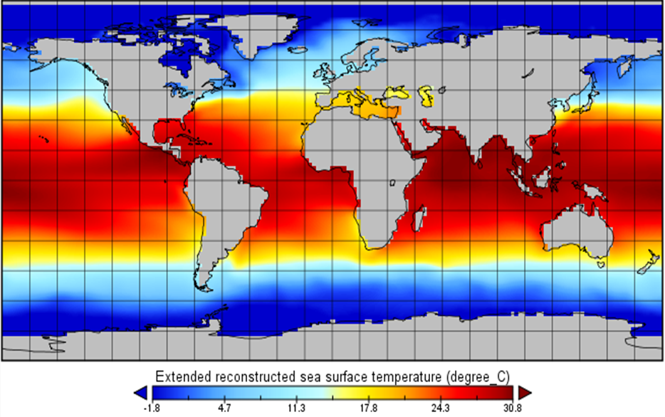
ERSST v4 image for May 2015.
The Extended Reconstructed Sea Surface Temperature (ERSST) dataset is a global monthly sea surface temperature analysis on a 2x2 degree grid derived from the International Comprehensive Ocean-Atmosphere Dataset (ICOADS). The latest ERSST Version 4 (v4) is based on Version 3b (v3b). Major revisions for v4 include: updated and substantively more complete input data from the ICOADS Release 2.5 (R2.5); revised Empirical Orthogonal Teleconnections (EOTs) and EOT acceptance criterion; updated sea surface temperature (SST) quality control procedures; revised SST anomaly (SSTA) evaluation methods; updated bias adjustments of ship SSTs using Hadley Nighttime Marine Air Temperature version 2 (HadNMAT2); and a buoy SST bias adjustment not previously made in v3b. ERSST v4 is generated using in situ SST data and improved statistical methods that allow stable reconstruction when data are sparse. The monthly analysis extends from January 1854 to the present, but because of sparse data in the early years, there is damping of the analyzed signal before 1880. After 1880, the strength of the signal is more consistent over time. The product is updated monthly with the available GTS ship and buoy data for that month. Data for the time period from January 2001 to the previous month are recalculated every month. Data before January 2001 are not updated. Note that v3b data were recalculated every month for January 1985 to the previous month. The SST anomalies are computed with respect to a 1971-2000 month climatology. Local and short-term variations have been smoothed in the ERSST analysis. The product is suitable for long-term global and basin-wide SST studies, and it is used as an input to the NCEI Merged Land Ocean Surface Temperature (MLOST) product. The data are written to a monthly netCDF files with CF metadata attributes included.
  • Cite as: Boyin Huang, Viva F. Banzon, Eric Freeman, Jay Lawrimore, Wei Liu, Thomas C. Peterson, Thomas M. Smith, Peter W. Thorne, Scott D. Woodruff, and Huai-Min Zhang, 2015: Extended Reconstructed Sea Surface Temperature (ERSST), Version 4. [indicate subset used]. NOAA National Centers for Environmental Information. doi:10.7289/V5KD1VVF [access date].
gov.noaa.ncdc:C00884
Download Data
Distribution Formats
  • netCDF (Version: 3)
    • File Specification: NetCDF file format following Climate and Forecast (CF) Metadata Conventions. See resources for NetCDF and CF Metadata, at http://www.unidata.ucar.edu/software/netcdf/ and http://cfconventions.org/
  • ASCII
    • File Specification: See ASCII format specification for ERSST v4: http://www1.ncdc.noaa.gov/pub/data/cmb/ersst/v4/ascii/Readme
  • XML
Ordering Instructions Contact NCEI for other distribution options and instructions.
Distributor NOAA National Centers for Environmental Information
ncei.info@noaa.gov
Dataset Point of Contact Customer Engagement Branch
NOAA National Centers for Environmental Information
1-828-271-4800
ncei.orders@noaa.gov
Dataset Point of Contact Boyin Huang
Physical Scientist
DOC/NOAA/NESDIS/NCEI > National Centers for Environmental Information, NESDIS, NOAA, U.S. Department of Commerce
+1 (828) 271-4851
boyin.huang@noaa.gov
Time Period 1854-01-01 to Present (time interval: 1-month)
Spatial Bounding Box Coordinates
West: -180.0
East: 180.0
South: -90.0
North: 90.0
Spatial Coverage Map
Dataset Information
General Documentation
Associated Resources
Publication Dates
  • publication: 2015-05-26
Edition Version 4
Dataset Progress Status Ongoing - data is continually being updated
Data Update Frequency Monthly
Purpose This dataset is suitable for long-term Global and basin-specific sea surface temperature studies by the climate research, monitoring and application communities.
Dataset Citation
  • Cite as: Boyin Huang, Viva F. Banzon, Eric Freeman, Jay Lawrimore, Wei Liu, Thomas C. Peterson, Thomas M. Smith, Peter W. Thorne, Scott D. Woodruff, and Huai-Min Zhang, 2015: Extended Reconstructed Sea Surface Temperature (ERSST), Version 4. [indicate subset used]. NOAA National Centers for Environmental Information. doi:10.7289/V5KD1VVF [access date].
Cited Authors
  • Huang, Boyin
    DOC/NOAA/NESDIS/NCEI > National Centers for Environmental Information, NESDIS, NOAA, U.S. Department of Commerce
  • Banzon, Viva F.
    DOC/NOAA/NESDIS/NCEI > National Centers for Environmental Information, NESDIS, NOAA, U.S. Department of Commerce
  • Freeman, Eric
    DOC/NOAA/NESDIS/NCEI > National Centers for Environmental Information, NESDIS, NOAA, U.S. Department of Commerce
  • Lawrimore, Jay
    DOC/NOAA/NESDIS/NCEI > National Centers for Environmental Information, NESDIS, NOAA, U.S. Department of Commerce
  • Liu, Wei
    DOC/NOAA/NESDIS/NCEI > National Centers for Environmental Information, NESDIS, NOAA, U.S. Department of Commerce
  • Peterson, Thomas C.
    DOC/NOAA/NESDIS/NCEI > National Centers for Environmental Information, NESDIS, NOAA, U.S. Department of Commerce
  • Smith, Thomas M.
    DOC/NOAA/NESDIS/STAR > Center for Satellite Applications and Research, NESDIS, NOAA, U.S. Department of Commerce
  • Thorne, Peter W.
    NERSC > Nansen Environmental and Remote Sensing Centre
  • Woodruff, Scott D.
    UCO/CIRES > Cooperative Institute for Research in Environmental Sciences, University of Colorado
  • Zhang, Huai-Min
    DOC/NOAA/NESDIS/NCEI > National Centers for Environmental Information, NESDIS, NOAA, U.S. Department of Commerce
Principal Investigators
  • Huang, Boyin
    DOC/NOAA/NESDIS/NCEI > National Centers for Environmental Information, NESDIS, NOAA, U.S. Department of Commerce
Collaborators
  • Banzon, Viva F.
    DOC/NOAA/NESDIS/NCEI > National Centers for Environmental Information, NESDIS, NOAA, U.S. Department of Commerce
  • Freeman, Eric
    DOC/NOAA/NESDIS/NCEI > National Centers for Environmental Information, NESDIS, NOAA, U.S. Department of Commerce
  • Lawrimore, Jay
    DOC/NOAA/NESDIS/NCEI > National Centers for Environmental Information, NESDIS, NOAA, U.S. Department of Commerce
  • Liu, Wei
    DOC/NOAA/NESDIS/NCEI > National Centers for Environmental Information, NESDIS, NOAA, U.S. Department of Commerce
  • Peterson, Thomas C.
    DOC/NOAA/NESDIS/NCEI > National Centers for Environmental Information, NESDIS, NOAA, U.S. Department of Commerce
  • Smith, Thomas M.
    DOC/NOAA/NESDIS/STAR > Center for Satellite Applications and Research, NESDIS, NOAA, U.S. Department of Commerce
  • Thorne, Peter W.
    NERSC > Nansen Environmental and Remote Sensing Centre
  • Woodruff, Scott D.
    UCO/CIRES > Cooperative Institute for Research in Environmental Sciences, University of Colorado
  • Zhang, Huai-Min
    DOC/NOAA/NESDIS/NCEI > National Centers for Environmental Information, NESDIS, NOAA, U.S. Department of Commerce
Publishers
  • NOAA National Centers for Environmental Information
Theme keywords Global Change Master Directory (GCMD) Science Keywords
  • Earth Science > Oceans > Ocean Temperature > Sea Surface Temperature
Global Climate Observing System (GCOS) Essential Climate Variables (ECVs)
  • Oceanic - Surface - Sea-surface Temperature
Data Center keywords Global Change Master Directory (GCMD) Data Center Keywords
  • DOC/NOAA/NESDIS/NCDC > National Climatic Data Center, NESDIS, NOAA, U.S. Department of Commerce
  • DOC/NOAA/NESDIS/NCEI > National Centers for Environmental Information, NESDIS, NOAA, U.S. Department of Commerce
Place keywords Global Change Master Directory (GCMD) Location Keywords
  • Geographic Region > Global Ocean
Data Resolution keywords Global Change Master Directory (GCMD) Horizontal Data Resolution Keywords
  • 100 km - < 250 km or approximately 1 degree - < 2.5 degrees
Stratum keywords Global Change Master Directory (GCMD) Location Keywords
  • Vertical Location > Sea Surface
Use Constraints
  • Cite as: Boyin Huang, Viva F. Banzon, Eric Freeman, Jay Lawrimore, Wei Liu, Thomas C. Peterson, Thomas M. Smith, Peter W. Thorne, Scott D. Woodruff, and Huai-Min Zhang, 2015: Extended Reconstructed Sea Surface Temperature (ERSST), Version 4. [indicate subset used]. NOAA National Centers for Environmental Information. doi:10.7289/V5KD1VVF [access date].
  • Use liability: NOAA and NCEI cannot provide any warranty as to the accuracy, reliability, or completeness of furnished data. Users assume responsibility to determine the usability of these data. The user is responsible for the results of any application of this data for other than its intended purpose.
Access Constraints
  • Distribution liability: NOAA and NCEI make no warranty, expressed or implied, regarding these data, nor does the fact of distribution constitute such a warranty. NOAA and NCEI cannot assume liability for any damages caused by any errors or omissions in these data. If appropriate, NCEI can only certify that the data it distributes are an authentic copy of the records that were accepted for inclusion in the NCEI archives.
Fees
  • In most cases, electronic downloads of the data are free. However, fees may apply for custom orders, data certifications, copies of analog materials, and data distribution on physical media.
Lineage information for: repository
Processing Steps
  • 2015-04-22T00:00:00 - NOAA created the National Centers for Environmental Information (NCEI) by merging NOAA's National Climatic Data Center (NCDC), National Geophysical Data Center (NGDC), and National Oceanographic Data Center (NODC), including the National Coastal Data Development Center (NCDDC), per the Consolidated and Further Continuing Appropriations Act, 2015, Public Law 113-235. NCEI launched publicly on April 22, 2015.
Last Modified: 2023-06-23
For questions about the information on this page, please email: ncei.info@noaa.gov