Dataset Overview | National Centers for Environmental Information (NCEI)

NOAA Extended Reconstructed Sea Surface Temperature (ERSST), Version 5

ERSSTv5

browse graphic
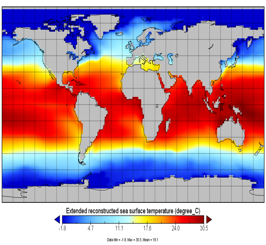
ERSST v5 image for January 2001.
The NOAA Extended Reconstructed Sea Surface Temperature (ERSST) dataset is a global monthly sea surface temperature dataset derived from the International Comprehensive Ocean-Atmosphere Dataset (ICOADS). It is produced on a 2 x 2 degree grid with spatial completeness enhanced using statistical methods. This monthly analysis begins in January 1854 continuing to the present and includes anomalies computed with respect to a 1971-2000 monthly climatology. Version 5 (v5) is the newest version of ERSST. Major revisions for v5 include: 1) using unadjusted first-guess instead of adjusted first-guess in QC, 2) using latest International Comprehensive Ocean Atmosphere Data Set (ICOADS) Release 3.0 (R3.0) over 1854-2015 instead of R2.5 over 1854-2007, 3) using Argo temperature above 5 meter depth that has not been used in previous version ERSST and other SST analysis, 4) using latest UK Met Office HadISST2 ice concentration over 1870-2015 instead of HadISST1 ice concentration over 1870-2010, 5) removing damping in high latitudes north of 60 degrees North and south of 50 degrees South in Empirical Orthogonal Teleconnection (EOT) Functions, 6) adding 10 more EOT modes in the Arctic, 7) reducing spatial filtering in training EOTs, and 8) revising ship SST bias correction relative to nighttime marine air temperature (NMAT) to the one relative to buoy SST observations. Other features remain same as in the previous ERSST version 4. The data are written to monthly netCDF files following CF Metadata Conventions.
  • Cite as: Boyin Huang, Peter W. Thorne, Viva F. Banzon, Tim Boyer, Gennady Chepurin, Jay H. Lawrimore, Matthew J. Menne, Thomas M. Smith, Russell S. Vose, and Huai-Min Zhang (2017): NOAA Extended Reconstructed Sea Surface Temperature (ERSST), Version 5. [indicate subset used]. NOAA National Centers for Environmental Information. doi:10.7289/V5T72FNM [access date].
gov.noaa.ncdc:C00927
Download Data
Distribution Formats
  • NetCDF (Version: 3)
    • File Specification: The NetCDF data files comply with the Climate and Forecast (CF) Metadata Conventions and the NetCDF Attribute Convention for Dataset Discovery (ACDD).
  • ASCII
    • File Specification: See ASCII format specification in Readme.
Ordering Instructions Contact NCEI for other distribution options and instructions.
Distributor NOAA National Centers for Environmental Information
ncei.info@noaa.gov
Dataset Point of Contact Customer Engagement Branch
NOAA National Centers for Environmental Information
1-828-271-4800
ncei.orders@noaa.gov
Dataset Point of Contact Boyin Huang
Physical Scientist
DOC/NOAA/NESDIS/NCEI > National Centers for Environmental Information, NESDIS, NOAA, U.S. Department of Commerce
+1 (828) 271-4851
boyin.huang@noaa.gov
Time Period 1854-01-01 to Present (time interval: 1-month)
Spatial Bounding Box Coordinates
West: -180.0
East: 180.0
South: -90.0
North: 90.0
Spatial Coverage Map
General Documentation
Associated Resources
Publication Dates
  • publication: 2017-07-19
Edition Version 5
Dataset Progress Status Ongoing - data is continually being updated
Data Update Frequency Monthly
Purpose This dataset is suitable for long-term Global and basin-specific sea surface temperature studies by the climate research, monitoring and application communities.
Dataset Citation
  • Cite as: Boyin Huang, Peter W. Thorne, Viva F. Banzon, Tim Boyer, Gennady Chepurin, Jay H. Lawrimore, Matthew J. Menne, Thomas M. Smith, Russell S. Vose, and Huai-Min Zhang (2017): NOAA Extended Reconstructed Sea Surface Temperature (ERSST), Version 5. [indicate subset used]. NOAA National Centers for Environmental Information. doi:10.7289/V5T72FNM [access date].
Cited Authors
  • Huang, Boyin
    DOC/NOAA/NESDIS/NCEI > National Centers for Environmental Information, NESDIS, NOAA, U.S. Department of Commerce
  • Thorne, Peter W.
    NERSC > Nansen Environmental and Remote Sensing Centre
  • Banzon, Viva F.
    DOC/NOAA/NESDIS/NCEI > National Centers for Environmental Information, NESDIS, NOAA, U.S. Department of Commerce
  • Boyer, Tim
    DOC/NOAA/NESDIS/NCEI > National Centers for Environmental Information, NESDIS, NOAA, U.S. Department of Commerce
  • Chepurin, Gennady
    DOC/NOAA/NESDIS/NCEI > National Centers for Environmental Information, NESDIS, NOAA, U.S. Department of Commerce
  • Lawrimore, Jay H.
    DOC/NOAA/NESDIS/NCEI > National Centers for Environmental Information, NESDIS, NOAA, U.S. Department of Commerce
  • Menne, Matthew J.
    DOC/NOAA/NESDIS/NCEI > National Centers for Environmental Information, NESDIS, NOAA, U.S. Department of Commerce
  • Smith, Thomas M.
    DOC/NOAA/NESDIS/STAR > Center for Satellite Applications and Research, NESDIS, NOAA, U.S. Department of Commerce
  • Vose, Russell S.
    DOC/NOAA/NESDIS/NCEI > National Centers for Environmental Information, NESDIS, NOAA, U.S. Department of Commerce
  • Zhang, Huai-Min
    DOC/NOAA/NESDIS/NCEI > National Centers for Environmental Information, NESDIS, NOAA, U.S. Department of Commerce
Principal Investigators
  • Huang, Boyin
    DOC/NOAA/NESDIS/NCEI > National Centers for Environmental Information, NESDIS, NOAA, U.S. Department of Commerce
Collaborators
  • Thorne, Peter W.
    NERSC > Nansen Environmental and Remote Sensing Centre
  • Banzon, Viva F.
    DOC/NOAA/NESDIS/NCEI > National Centers for Environmental Information, NESDIS, NOAA, U.S. Department of Commerce
  • Boyer, Tim
    DOC/NOAA/NESDIS/NCEI > National Centers for Environmental Information, NESDIS, NOAA, U.S. Department of Commerce
  • Chepurin, Gennady
    DOC/NOAA/NESDIS/NCEI > National Centers for Environmental Information, NESDIS, NOAA, U.S. Department of Commerce
  • Lawrimore, Jay H.
    DOC/NOAA/NESDIS/NCEI > National Centers for Environmental Information, NESDIS, NOAA, U.S. Department of Commerce
  • Menne, Matthew J.
    DOC/NOAA/NESDIS/NCEI > National Centers for Environmental Information, NESDIS, NOAA, U.S. Department of Commerce
  • Smith, Thomas M.
    DOC/NOAA/NESDIS/STAR > Center for Satellite Applications and Research, NESDIS, NOAA, U.S. Department of Commerce
  • Vose, Russell S.
    DOC/NOAA/NESDIS/NCEI > National Centers for Environmental Information, NESDIS, NOAA, U.S. Department of Commerce
  • Zhang, Huai-Min
    DOC/NOAA/NESDIS/NCEI > National Centers for Environmental Information, NESDIS, NOAA, U.S. Department of Commerce
Publishers
  • DOC/NOAA/NESDIS/NCEI > National Centers for Environmental Information, NESDIS, NOAA, U.S. Department of Commerce
Theme keywords Global Change Master Directory (GCMD) Science Keywords
  • Earth Science > Oceans > Ocean Temperature > Sea Surface Temperature
Global Climate Observing System (GCOS) Essential Climate Variables (ECVs)
  • Oceanic - Surface - Sea-surface Temperature
Data Center keywords Global Change Master Directory (GCMD) Data Center Keywords
  • DOC/NOAA/NESDIS/NCDC > National Climatic Data Center, NESDIS, NOAA, U.S. Department of Commerce
  • DOC/NOAA/NESDIS/NCEI > National Centers for Environmental Information, NESDIS, NOAA, U.S. Department of Commerce
Place keywords Global Change Master Directory (GCMD) Location Keywords
  • Geographic Region > Global Ocean
Data Resolution keywords Global Change Master Directory (GCMD) Horizontal Data Resolution Keywords
  • 100 km - < 250 km or approximately 1 degree - < 2.5 degrees
Stratum keywords Global Change Master Directory (GCMD) Location Keywords
  • Vertical Location > Sea Surface
Use Constraints
  • Cite as: Boyin Huang, Peter W. Thorne, Viva F. Banzon, Tim Boyer, Gennady Chepurin, Jay H. Lawrimore, Matthew J. Menne, Thomas M. Smith, Russell S. Vose, and Huai-Min Zhang (2017): NOAA Extended Reconstructed Sea Surface Temperature (ERSST), Version 5. [indicate subset used]. NOAA National Centers for Environmental Information. doi:10.7289/V5T72FNM [access date].
  • Publications using this dataset should also reference the following journal article: Huang, B., Peter W. Thorne, Viva F. Banzon, Tim Boyer, Gennady Chepurin, Jay H. Lawrimore, Matthew J. Menne, Thomas M. Smith, Russell S. Vose, and Huai-Min Zhang, 2017: Extended Reconstructed Sea Surface Temperature version 5 (ERSSTv5), Upgrades, validations, and intercomparisons. J. Climate, https://doi.org/10.1175/JCLI-D-16-0836.1. In review.
  • Use liability: NOAA and NCEI cannot provide any warranty as to the accuracy, reliability, or completeness of furnished data. Users assume responsibility to determine the usability of these data. The user is responsible for the results of any application of this data for other than its intended purpose.
Access Constraints
  • Distribution liability: NOAA and NCEI make no warranty, expressed or implied, regarding these data, nor does the fact of distribution constitute such a warranty. NOAA and NCEI cannot assume liability for any damages caused by any errors or omissions in these data. If appropriate, NCEI can only certify that the data it distributes are an authentic copy of the records that were accepted for inclusion in the NCEI archives.
Fees
  • In most cases, electronic downloads of the data are free. However, fees may apply for custom orders, data certifications, copies of analog materials, and data distribution on physical media.
Lineage information for: repository
Processing Steps
  • 2015-04-22T00:00:00 - NOAA created the National Centers for Environmental Information (NCEI) by merging NOAA's National Climatic Data Center (NCDC), National Geophysical Data Center (NGDC), and National Oceanographic Data Center (NODC), including the National Coastal Data Development Center (NCDDC), per the Consolidated and Further Continuing Appropriations Act, 2015, Public Law 113-235. NCEI launched publicly on April 22, 2015.
Last Modified: 2023-06-23
For questions about the information on this page, please email: ncei.info@noaa.gov