NUCAPS: NOAA Unique Combined Atmospheric Processing System Outgoing Longwave Radiation (OLR)
NUCAPS-OLR-NDE
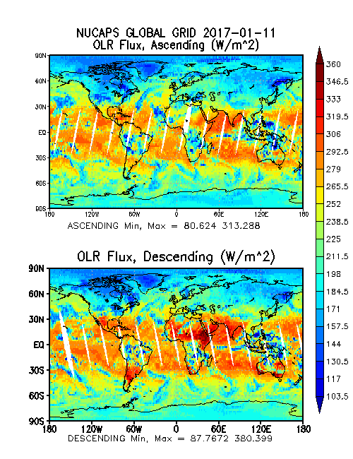 Global images of OLR Flux ascending and descending. Image courtesy of NOAA OSPO.
This data set consists of Outgoing Longwave Radiation (OLR) from the NOAA Unique Combined Atmospheric Processing System (NUCAPS). NUCAPS was developed by the NOAA/NESDIS Center for Satellite Application and Research (STAR) and is produced operationally at the NOAA/NESDIS Office of Satellite and Product Operations (OSPO). The Cross-track Infrared Sounder (CrIS) onboard the Suomi National Polar-orbiting Partnership (S-NPP) satellite is a Fourier transform spectrometer with a total of 1,305 spectral channels covering the longwave IR (9.14 - 15.38 um), midwave IR (5.71 - 8.26 um) and shortwave IR (3.92 - 4.64 um) wavelengths. The Advanced Technology Microwave Sounder (ATMS) also onboard the S-NPP satellite is a cross-track scanner with 22 channels in spectral bands from 23 GHz through 183 GHz. Each product file encompasses one 32-second granule of data, corresponding to 4 scan lines of CrIS/ATMS data. The products are distributed in netCDF-4 file format with metadata attributes included.
- Cite as: Liu, Quanhua, Wolf, Walter, Reale, Tony, Sharma, Awdhesh, and NOAA JPSS Program Office (2014): NUCAPS: NOAA Unique Combined Atmospheric Processing System Outgoing Longwave Radiation (OLR). [indicate subset used]. NOAA National Centers for Environmental Information. doi:10.7289/V5RV0KRF. [access date].
| Download Data |
-
NOAA CLASS FTP Server (download)
Access and download data tar files by date and product for the previous 85 days. The directory structure is as follows, date(yyyymmdd)->instrument family->product.
|
| Order Data |
|
| Distribution Formats |
|
| Ordering Instructions |
Contact NCEI for other distribution options and instructions. |
| Distributor |
NOAA National Centers for Environmental Information
ncei.info@noaa.gov
|
| Dataset Point of Contact |
DOC/NOAA/NESDIS/NCEI > National Centers for Environmental Information, NESDIS, NOAA, U.S. Department of Commerce
ncei.sat.info@noaa.gov
|
| Time Period |
2014-04-07 to Present (time interval: 1-day) |
| Spatial Reference System |
urn:ogc:def:crs:EPSG::4326 |
| Spatial Bounding Box Coordinates |
West: -180.0
East: 180.0
South: -90.0
North: 90.0
|
| Spatial Coverage Map |
|
| General Documentation |
|
| Processing Documents |
- JPSS STAR Science Documents
- OSPO NUCAPS Documentation
|
| Associated Resources |
- The NOAA Unique CrIS/ATMS Processing System (NUCAPS): First Light Retrieval Results.
-
Conference paper presented March 2012 at International TOVS Working Group (ITWG) in Toulouse, France
Gambacorta, A., Barnet, C., et al., (2012), The NOAA Unique CrIS/ATMS Processing System (NUCAPS): First Light Retrieval Results, In Proceedings of the ITWG Meeting, Toulouse, France.
|
| Publication Dates |
|
| Edition |
Version 1.0 |
| Data Presentation Form |
Digital image
|
| Dataset Progress Status |
Ongoing - data is continually being updated |
| Data Update Frequency |
Continual |
| Purpose |
NUCAPS data could be used by the geophysical research and weather forecasting communities |
| Use Limitations |
- For a complete description of use limitations for this EDR, see the Algorithm Theoretical Basis Document (ATBD).
|
| Dataset Citation |
- Cite as: Liu, Quanhua, Wolf, Walter, Reale, Tony, Sharma, Awdhesh, and NOAA JPSS Program Office (2014): NUCAPS: NOAA Unique Combined Atmospheric Processing System Outgoing Longwave Radiation (OLR). [indicate subset used]. NOAA National Centers for Environmental Information. doi:10.7289/V5RV0KRF. [access date].
|
| Cited Authors |
- NOAA JPSS Program Office
- Liu, Quanhua
DOC/NOAA/NESDIS/STAR > Center for Satellite Applications and Research, NESDIS, NOAA, U.S. Department of Commerce
- Wolf, Walter
DOC/NOAA/NESDIS/STAR > Center for Satellite Applications and Research, NESDIS, NOAA, U.S. Department of Commerce
- Reale, Tony
DOC/NOAA/NESDIS/STAR > Center for Satellite Applications and Research, NESDIS, NOAA, U.S. Department of Commerce
- Sharma, Awdhesh
DOC/NOAA/NESDIS/OSPO > Office of Satellite and Product Operations, NESDIS, NOAA, U.S. Department of Commerce
|
| Originators |
|
| Principal Investigators |
- Liu, Quanhua
DOC/NOAA/NESDIS/STAR > Center for Satellite Applications and Research, NESDIS, NOAA, U.S. Department of Commerce
- Wolf, Walter
DOC/NOAA/NESDIS/STAR > Center for Satellite Applications and Research, NESDIS, NOAA, U.S. Department of Commerce
- Reale, Tony
DOC/NOAA/NESDIS/STAR > Center for Satellite Applications and Research, NESDIS, NOAA, U.S. Department of Commerce
- Sharma, Awdhesh
DOC/NOAA/NESDIS/OSPO > Office of Satellite and Product Operations, NESDIS, NOAA, U.S. Department of Commerce
|
| Publishers |
- NOAA National Centers for Environmental Information
|
| Theme keywords |
Global Change Master Directory (GCMD) Science Keywords- Earth Science > Atmosphere > Atmospheric Radiation > Outgoing Longwave Radiation
Global Climate Observing System (GCOS) Essential Climate Variables (ECVs)- Atmospheric - Upper-air - Earth Radiation Budget
|
| Data Center keywords |
Global Change Master Directory (GCMD) Data Center Keywords
- DOC/NOAA/NESDIS/STAR > Center for Satellite Applications and Research, NESDIS, NOAA, U.S. Department of Commerce
- DOC/NOAA/NESDIS/NCDC > National Climatic Data Center, NESDIS, NOAA, U.S. Department of Commerce
- DOC/NOAA/NESDIS/NCEI > National Centers for Environmental Information, NESDIS, NOAA, U.S. Department of Commerce
- DOC/NOAA/NESDIS/OSPO > Office of Satellite and Product Operations, NESDIS, NOAA, U.S. Department of Commerce
|
| Platform keywords |
Global Change Master Directory (GCMD) Platform Keywords- SUOMI-NPP > Suomi National Polar-orbiting Partnership
|
| Instrument keywords |
Global Change Master Directory (GCMD) Instrument Keywords
- CRIS-NPP > Cross-track Infrared Sounder
- ATMS > Advanced Technology Microwave Sounder
|
| Place keywords |
Global Change Master Directory (GCMD) Location Keywords- Geographic Region > Global
|
| Project keywords |
Global Change Master Directory (GCMD) Project Keywords
- NOAA OneStop Project
- JPSS > Joint Polar Satellite System
- NDE > NESDIS Data Exploitation
|
| Data Resolution keywords |
Global Change Master Directory (GCMD) Temporal Data Resolution Keywords
Global Change Master Directory (GCMD) Horizontal Data Resolution Keywords- 10 km - < 50 km or approximately .09 degree - < .5 degree
|
| Stratum keywords |
Global Change Master Directory (GCMD) Location Keywords- Vertical Location > Troposphere
|
| Use Constraints |
- Cite as: Liu, Quanhua, Wolf, Walter, Reale, Tony, Sharma, Awdhesh, and NOAA JPSS Program Office (2014): NUCAPS: NOAA Unique Combined Atmospheric Processing System Outgoing Longwave Radiation (OLR). [indicate subset used]. NOAA National Centers for Environmental Information. doi:10.7289/V5RV0KRF. [access date].
- Use liability: NOAA and NCEI cannot provide any warranty as to the accuracy, reliability, or completeness of furnished data. Users assume responsibility to determine the usability of these data. The user is responsible for the results of any application of this data for other than its intended purpose.
|
| Access Constraints |
- Distribution liability: NOAA and NCEI make no warranty, expressed or implied, regarding these data, nor does the fact of distribution constitute such a warranty. NOAA and NCEI cannot assume liability for any damages caused by any errors or omissions in these data. If appropriate, NCEI can only certify that the data it distributes are an authentic copy of the records that were accepted for inclusion in the NCEI archives.
|
| Fees |
- In most cases, electronic downloads of the data are free. However, fees may apply for custom orders, data certifications, copies of analog materials, and data distribution on physical media.
|
| Lineage information for: dataset |
|---|
| Lineage Statement |
The data were produced by the NOAA Office of Satellite and Product Operations (OSPO) NDE/PDA and are archived at the NOAA National Centers for Environmental Information (NCEI). |
| Processor |
- DOC/NOAA/NESDIS/STAR > Center for Satellite Applications and Research, NESDIS, NOAA, U.S. Department of Commerce
- DOC/NOAA/NESDIS/STAR > Center for Satellite Applications and Research, NESDIS, NOAA, U.S. Department of Commerce
- DOC/NOAA/NESDIS/STAR > Center for Satellite Applications and Research, NESDIS, NOAA, U.S. Department of Commerce
- DOC/NOAA/NESDIS/STAR > Center for Satellite Applications and Research, NESDIS, NOAA, U.S. Department of Commerce
|
| Processing Steps |
- For a complete description of the processing steps, see the Algorithm Theoretical Basis Document and Data Flow Diagram.
- 2016-10-18T00:00:00Z - The S-NPP NUCAPS OLR algorithm reached validated maturity.
- 2018-06-15T00:00:00Z - The NOAA-20 NUCAPS OLR algorithm reached beta maturity.
- The NOAA-20 NUCAPS OLR algorithm reached provisional maturity.
- The NOAA-20 NUCAPS OLR algorithm reached validated maturity.
|
| Processing Documents |
- JPSS STAR Science Documents
- OSPO NUCAPS Documentation
|
| Source Datasets |
- NOAA JPSS Cross-track Infrared Sounder (CrIS) Science Sensor Data Record (SDR) from IDPS
-
Landing page for JPSS-CrIS-SDR
Source dataset landing page with general information and access links for the dataset.
- Description of Source: Sensor Data Record (SDR)
- Temporal extent used: 2012-04-19 to Present
- Spatial extent used: N:90 S:-90 E:180 W:-180
- NOAA JPSS Advanced Technology Microwave Sounder Sensor (ATMS) Sensor Data Record (SDR) from IDPS
-
NCEI landing page for JPSS-ATMS-SDR
Source dataset landing page with general information and access links for the dataset.
- Description of Source: Sensor Data Record (SDR)
- Temporal extent used: 2012-04-19 to Present
- Spatial extent used: N:90 S:-90 E:180 W:-180
- NOAA JPSS Advanced Technology Microwave Sounder (ATMS) Temperature Data Record (TDR) from IDPS
-
NCEI landing page for JPSS-ATMS-TDR
Source dataset landing page with general information and access links for the dataset.
- Description of Source: Temperature Data Record (TDR)
- Temporal extent used: 2011-12-10 to Present
- Spatial extent used: N:90 S:-90 E:180 W:-180
|
| Lineage information for: repository |
|---|
| Processing Steps |
- 2015-04-22T00:00:00 - NOAA created the National Centers for Environmental Information (NCEI) by merging NOAA's National Climatic Data Center (NCDC), National Geophysical Data Center (NGDC), and National Oceanographic Data Center (NODC), including the National Coastal Data Development Center (NCDDC), per the Consolidated and Further Continuing Appropriations Act, 2015, Public Law 113-235. NCEI launched publicly on April 22, 2015.
|
Last Modified: 2023-06-23
For questions about the information on this page, please email:
ncei.info@noaa.gov