Dataset Overview | National Centers for Environmental Information (NCEI)

NOAA Climate Data Record (CDR) of Zonal Mean Ozone Binary Database of Profiles (BDBP), version 1.0

Ozone - ESRL; NOAA Ozone ESRL CDR

browse graphic
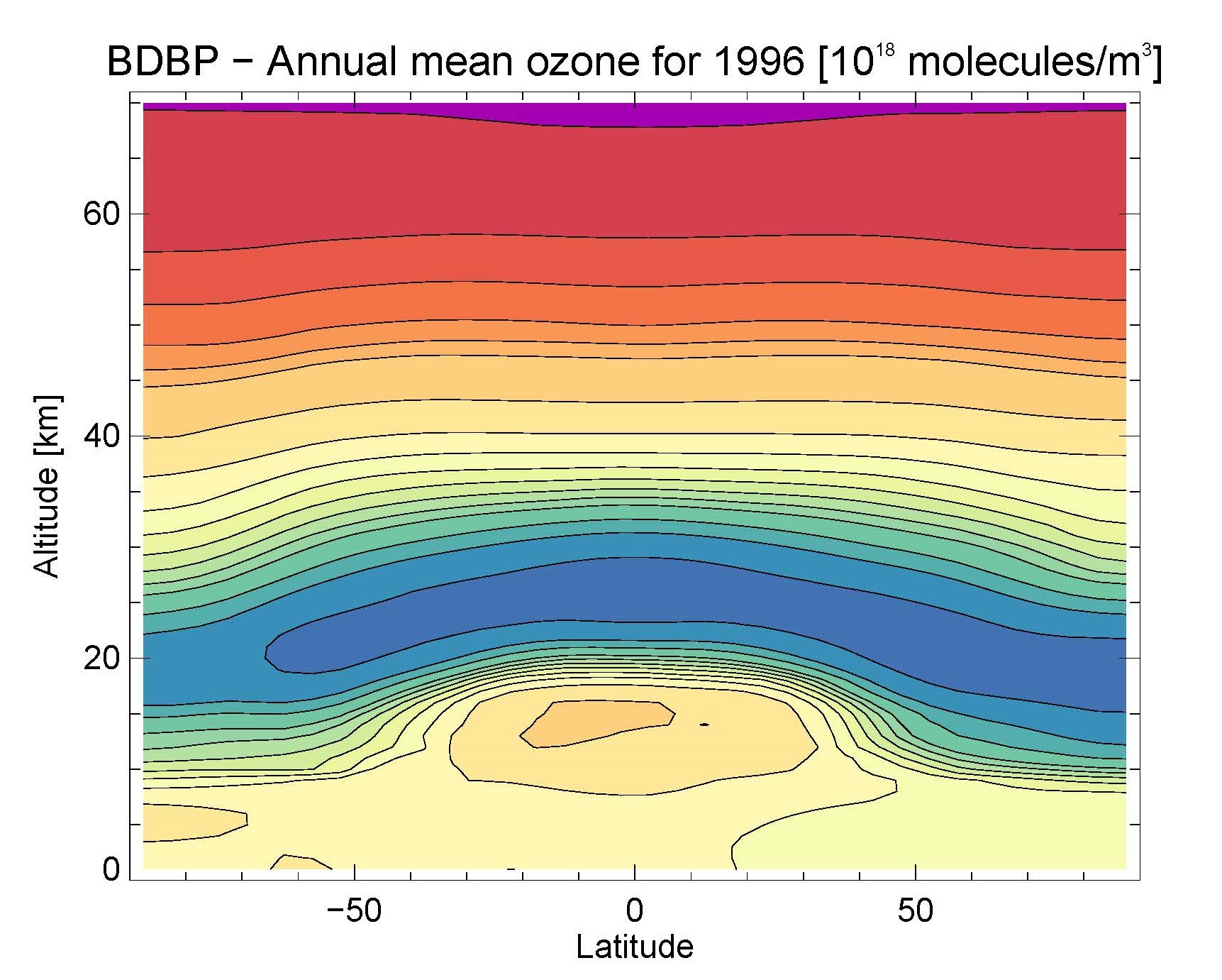
Global Annual Ozone Mean for 1996
This NOAA Climate Data Record (CDR) of Zonal Mean Ozone Binary Database of Profiles (BDBP) dataset is a vertically resolved, global, gap-free and zonal mean dataset that was created with a multiple-linear regression model. The dataset has a monthly resolution and spans the period 1979 to 2007. It provides global product in 5 degree zonal bands, and 70 vertical levels of the atmosphere. The regression is based on monthly mean ozone concentrations that were calculated from several different satellite instruments and global ozone soundings. Due to the regression model that was used to create the product, various basis function contributions are provided as unique levels or tiers. To understand the different contributions of basis functions, the data product is provided in five different "Tiers". - Tier 0: raw monthly mean data that was used in the regression model - Tier 1.1: Anthropogenic influences (as determined by the regression model) - Tier 1.2: Natural influences (as determined by the regression model) - Tier 1.3: Natural and volcanic influences (as determined by the regression model) - Tier 1.4: All influences (as determined by the regression model, CDR variable)
  • Cite as: Rosenlof, Karen, Bodeker, G. E., Hassler, B., and NOAA CDR Program: NOAA Climate Data Record (CDR) of Zonal Mean Ozone Binary Database of Profiles (BDBP), Version 1.0. [indicate subset used]. NOAA National Climatic Data Center. doi:10.7289/V56M34RT [access date].
  • Please refer to Credit tab for full citation information.
gov.noaa.ncdc:C00930
Download Data
Distribution Formats
  • XML
  • NetCDF (Version: 4)
  • netCDF-4
    • File Compression:
Ordering Instructions Contact NCEI for other distribution options and instructions.
Distributor NOAA National Centers for Environmental Information
ncei.info@noaa.gov
Dataset Point of Contact NOAA Climate Data Record Program Office
DOC/NOAA/NESDIS/NCEI > National Centers for Environmental Information, NESDIS, NOAA, U.S. Department of Commerce
+1 (828) 271-4800
ozone_esrl_contacts@noaa.gov
Time Period 1979 to 2007 (time interval: 1-month)
Spatial Bounding Box Coordinates
West: -180.0
East: 180.0
South: -90.0
North: 90.0
Spatial Coverage Map
Dataset Information
  • Ozone - ESRL - NOAA Landing Page
    The dataset provides advanced scientific researchers a high quality Climate Data Record (CDR) of ozone at multiple altitude or pressure levels. The monthly means that are the basis for the regression model can also be used for ozone data analyses directly, e.g. trend studies. However, these are not available for all months of the period 1979 to 2007, and not all latitude bands.
General Documentation
Processing Documents
Associated Resources
Publication Dates
  • publication: 2015-04-01
Edition Version 1.0
Data Presentation Form Digital table - digital representation of facts or figures systematically displayed, especially in columns
Dataset Progress Status Complete - production of the data has been completed
Data Update Frequency As needed
Purpose The dataset provides advanced scientific researchers a high quality Climate Data Record (CDR) of ozone at multiple altitude or pressure levels. The monthly means that are the basis for the regression model can also be used for ozone data analyses directly, e.g. trend studies. However, these are not available for all months of the period 1979 to 2007, and not all latitude bands.
Use Limitations
  • Since the dataset is based on regression model output, it does not represent direct measurements, but a best estimate on observed ozone concentrations. Trend analyses or process studies should therefore not be performed on the dataset. For a complete description of use limitations for this CDR, see Section 6, Assumptions and Limitations, in the respective Algorithm Theoretical Basis Document.
Dataset Citation
  • Cite as: Rosenlof, Karen, Bodeker, G. E., Hassler, B., and NOAA CDR Program: NOAA Climate Data Record (CDR) of Zonal Mean Ozone Binary Database of Profiles (BDBP), Version 1.0. [indicate subset used]. NOAA National Climatic Data Center. doi:10.7289/V56M34RT [access date].
  • Publications using this CDR should also cite the following journal article: Bodeker, G. E., Hassler, B., Young, P. J., & Portmann, R. W. (2013). A vertically resolved, global, gap-free ozone database for assessing or constraining global climate model simulations. Earth System Science Data, 5(1), 31-43. doi:10.5194/essd-5-31-2013
Cited Authors
  • Hassler, Birgit
    UCO/CIRES > Cooperative Institute for Research in Environmental Sciences, University of Colorado
  • Bodeker, Greg
    Bodeker Scientific
  • Rosenlof, Karen
    NOAA/ESRL/CSD
  • NOAA CDR Program
    DOC/NOAA/NESDIS/NCDC > National Climatic Data Center, NESDIS, NOAA, U.S. Department of Commerce
Originators
  • Hassler, Birgit
    UCO/CIRES > Cooperative Institute for Research in Environmental Sciences, University of Colorado
Principal Investigators
  • Rosenlof, Karen
    NOAA/ESRL/CSD
Collaborators
  • Bodeker, Greg
    Bodeker Scientific
  • NOAA CDR Program
    DOC/NOAA/NESDIS/NCDC > National Climatic Data Center, NESDIS, NOAA, U.S. Department of Commerce
Publishers
  • DOC/NOAA/NESDIS/NCEI > National Centers for Environmental Information, NESDIS, NOAA, U.S. Department of Commerce
  • DOC/NOAA/NESDIS/NCDC > National Climatic Data Center, NESDIS, NOAA, U.S. Department of Commerce
Theme keywords Global Change Master Directory (GCMD) Science Keywords
  • Earth Science > Atmosphere > Atmospheric Chemistry > oxygen Compounds
  • Earth Science > Atmosphere > Atmospheric Chemistry > trace Gases/Trace Species
Global Climate Observing System (GCOS) Essential Climate Variables (ECVs)
  • Atmospheric - Composition - Precursors supporting The Aerosol And Ozone Ecvs (including No2, So2, Hcho and Co)
Data Center keywords Global Change Master Directory (GCMD) Data Center Keywords
  • DOC/NOAA/NESDIS/NCDC > National Climatic Data Center, NESDIS, NOAA, U.S. Department of Commerce
  • DOC/NOAA/NESDIS/NCEI > National Centers for Environmental Information, NESDIS, NOAA, U.S. Department of Commerce
  • DOC/NOAA/ESRL/CSD
  • UCO/CIRES > Cooperative Institute for Research in Environmental Sciences, University of Colorado
Platform keywords Global Change Master Directory (GCMD) Platform Keywords
  • ERBS > Earth Radiation Budget Satellite
  • AEM-2 > Applications Explorer Mission-2
  • SPOT-3 > Systeme Probatoire Pour l'Observation de la Terre-3
  • SPOT-4 > Systeme Probatoire Pour l'Observation de la Terre-4
  • UARS > Upper Atmosphere Research Satellite
  • ADEOS-1 > Advanced Earth Observing Satellite-I
  • ADEOS-2 > Advanced Earth Observing Satellite-II
  • NIMBUS-7
Instrument keywords Global Change Master Directory (GCMD) Instrument Keywords
  • POAM II > Polar Ozone and Aerosol Measurement II
  • POAM III > Polar Ozone and Aerosol Measurement III
  • SAGE I > Stratospheric Aerosol and Gas Experiment I
  • SAGE II > Stratospheric Aerosol and Gas Experiment II
  • HALOE > Halogen Occultation Experiment
  • ILAS > Improved Limb Atmospheric Spectrometer
  • ILAS II > Improved Limb Atmospheric Spectrometer-II
  • LIMS > Limb Infrared Monitor of the Stratosphere
  • OZONESONDES
Place keywords Global Change Master Directory (GCMD) Location Keywords
  • Vertical Location > Stratosphere
  • Vertical Location > Mesosphere
  • Geographic Region > Global
Project keywords Keyword Thesaurus Title
  • NOAA Climate Data Record (CDR) Program
Global Change Master Directory (GCMD) Project Keywords
  • ESRL > Earth System Research Laboratory (NOAA)
  • NOAA OneStop Project
Stratum keywords Global Change Master Directory (GCMD) Location Keywords
  • Vertical Location > Stratosphere
  • Vertical Location > Mesosphere
Use Constraints
  • Cite as: Rosenlof, Karen, Bodeker, G. E., Hassler, B., and NOAA CDR Program: NOAA Climate Data Record (CDR) of Zonal Mean Ozone Binary Database of Profiles (BDBP), Version 1.0. [indicate subset used]. NOAA National Climatic Data Center. doi:10.7289/V56M34RT [access date].
  • Publications using this CDR should also cite the following journal article: Bodeker, G. E., Hassler, B., Young, P. J., & Portmann, R. W. (2013). A vertically resolved, global, gap-free ozone database for assessing or constraining global climate model simulations. Earth System Science Data, 5(1), 31-43. doi:10.5194/essd-5-31-2013
  • Use liability: NOAA and NCEI cannot provide any warranty as to the accuracy, reliability, or completeness of furnished data. Users assume responsibility to determine the usability of these data. The user is responsible for the results of any application of this data for other than its intended purpose.
Access Constraints
  • Distribution liability: NOAA and NCEI make no warranty, expressed or implied, regarding these data, nor does the fact of distribution constitute such a warranty. NOAA and NCEI cannot assume liability for any damages caused by any errors or omissions in these data. If appropriate, NCEI can only certify that the data it distributes are an authentic copy of the records that were accepted for inclusion in the NCEI archives.
Fees
  • In most cases, electronic downloads of the data are free. However, fees may apply for custom orders, data certifications, copies of analog materials, and data distribution on physical media.
Lineage information for: dataset
Lineage Statement The data were produced by NOAA ESRL Chemical Sciences Division (CSD), University of Colorado CIRES, and Bodeker Scientific and are archived at the NOAA National Climatic Data Center (NCDC). Updates to extend the Ozone ESRL CDR data set to the present are anticipated, pending adequate funding. For more information, see associated processing documentation.
Processor
  • DOC/NOAA/ESRL/CSD > Chemical Sciences Division, Earth System Research Laboratory, NOAA, U.S. Department of Commerce
Processing Steps
  • For a complete description of the processing steps, see the Algorithm Theoretical Basis Document and Data Flow Diagram.
Processing Documents
Source Datasets
  • Stratospheric Aerosol and Gas Experiment I (SAGE I) Ozone Profiles
    • Stratospheric Aerosol and Gas Experiment I (SAGE I) Ozone Profiles
      NASA website for SAGE I data concerning the spatial distribution of stratospheric aerosols, ozone and nitrogen dioxide on a global scale. SAGE I used a Sun Photometer.
    • Description of Source: Solar-occultation satellite ozone profiles, 1km vertical resolution, up to 15 sunrise and sunset events per day, covered weavelengths 0.385 - 1.00 mircons.
    • Temporal extent used: 1979-02-01 to 1981-11-30
    • Spatial extent used: N:79 S:-79 E:180 W:-180
  • Stratospheric Aerosol and Gas Experiment II (SAGE II) Ozone Profiles
    • Stratospheric Aerosol and Gas Experiment II (SAGE II) Ozone Profiles
      NASA website for SAGE II data concerning the spatial distribution of stratospheric aerosols, ozone and nitrogen dioxide on a global scale. SAGE II used a Sun Photometer.
    • Description of Source: Solar-occultation satellite ozone profiles, 1km vertical resolution, up to 15 sunrise and sunset events per day, covered weavelengths 0.385 - 1.02 mircons.
    • Temporal extent used: 1984-10-01 to 2005-08-31
    • Spatial extent used: N:80 S:-80 E:180 W:-180
  • Halogen Occultation Experiment (HALOE) Ozone Profiles
    • Halogen Occultation Experiment (HALOE) Ozone Profiles
      NASA website for HALOE data measuring vertical profiles of stratospheric aerosols, ozone, nitrogen dioxide and others on a global scale. HALOE uses the principle of satellite solar occultation to sound the stratosphere, mesosphere, and lower thermosphere.
    • Description of Source: Solar-occultation satellite ozone profiles, 1.6km vertical resolution,covering Cloud top/tropopause - 0.005hPa, up to 15 sunrise and sunset events per day, covered weavelengths 9.2 - 10.4 mircons.
    • Temporal extent used: 1991-10-01 to 2005-11-30
    • Spatial extent used: N:80 S:-80 E:180 W:-180
  • Polar Ozone and Aerosol Measurement (POAM) II Ozone Profiles
    • Polar Ozone and Aerosol Measurement (POAM) II Ozone Profiles
      NASA website for Polar Ozone and Aerosol Measurement (POAM) II instrument measures the vertical distribution of atmospheric ozone, water vapor, nitrogen dioxide, and aerosol extinction.
    • Description of Source: Solar-occultation satellite ozone profiles, 1km vertical resolution, covering Cloud top/ 5-60km, up to 14 sunrise and sunset events per day, covered weavelengths 0.35 - 1.06 mircons.
    • Temporal extent used: 1993-10-01 to 1996-11-30
    • Spatial extent used: N:88 S:71 E:180 W:-180
  • Polar Ozone and Aerosol Measurement (POAM) III Ozone Profiles
    • Polar Ozone and Aerosol Measurement (POAM) III Ozone Profiles
      NASA website for Polar Ozone and Aerosol Measurement (POAM) III instrument measures the vertical distribution of atmospheric ozone, water vapor, nitrogen dioxide, and aerosol extinction.
    • Description of Source: Solar-occultation satellite ozone profiles, 1km vertical resolution, covering Cloud top/ 5-60km, up to 14 sunrise and sunset events per day, covered weavelengths 0.35 - 1.02 mircons.
    • Temporal extent used: 1998-04-01 to 2005-11-30
    • Spatial extent used: N:88 S:71 E:180 W:-180
  • Improved Limb Array Sprectometer (ILAS) Ozone Profiles
    • Improved Limb Array Sprectometer (ILAS) Ozone Profiles
      NIES website for the ILAS satellite data and documentation.
    • Description of Source: Solar-occultation satellite ozone profiles, 1.9km vertical resolution, covering Cloud top/ 10km - top of atmosphere, up to 14 sunrise and sunset events per day, covered weavelengths 6-12 mircons.
    • Temporal extent used: 1996-09-01 to 1997-06-30
    • Spatial extent used: N:88 S:71 E:180 W:-180
  • Improved Limb Array Sprectometer (ILAS) II Ozone Profiles
    • Improved Limb Array Sprectometer (ILAS) II Ozone Profiles
      NIES website for the ILAS II satellite data and documentation.
    • Description of Source: Solar-occultation satellite ozone profiles, 1.6km vertical resolution, covering Cloud top/ 10km - top of atmosphere, up to 14 sunrise and sunset events per day, covered weavelengths 6-12 mircons.
    • Temporal extent used: 2003-03-01 to 2003-10-31
    • Spatial extent used: N:88 S:71 E:180 W:-180
  • Limb Infrared Monitor of the Stratosphere (LIMS) emission
    • Description of Source: Limb Infrared Monitor of the Stratosphere (LIMS) emission, 3.7km vertical resolution, 3000 profiles per day, Cloud top/300hPa - 0.01hPa, 9 to 10 mircons
    • Temporal extent used: 1978-10-01 to 1979-05-31
    • Spatial extent used: N:84 S:64 E:180 W:-180
  • Ozonesondes from various sites
    • Description of Source: Ozonesondes-Chemical reaction of ozone with potassium iodine in an aqueous solution, 1-2 soundings per week, 100-150m vertical resolution, covering surface - 30-35km vertically. Global long-term ground-based sites: ozone sounding, lidar, microwave, Dobson/Brewer with Umkehr measurements, and FTIR. Shorter records from WOUDC and NDACC data bases.
    • Temporal extent used: 1979-01-01 to 2007-12-31
    • Spatial extent used: N:90 S:-90 E:180 W:-180
Lineage information for: repository
Processing Steps
  • 2015-04-22T00:00:00 - NOAA created the National Centers for Environmental Information (NCEI) by merging NOAA's National Climatic Data Center (NCDC), National Geophysical Data Center (NGDC), and National Oceanographic Data Center (NODC), including the National Coastal Data Development Center (NCDDC), per the Consolidated and Further Continuing Appropriations Act, 2015, Public Law 113-235. NCEI launched publicly on April 22, 2015.
Last Modified: 2023-08-10
For questions about the information on this page, please email: ncei.info@noaa.gov