NOAA Climate Data Record of Microwave Sounding Unit (MSU) and Advanced Microwave Sounding Unit (AMSU-A) Mean Layer Temperature, Version 3.0
Mean Layer Temperature - NOAA
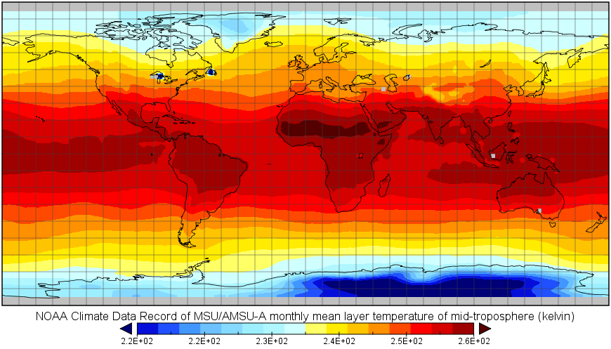 MLT Sample Image
The dataset contains three channel-based, monthly gridded atmospheric layer temperature Climate Data Records generated by merging nine MSU NOAA polar orbiting satellites, TIROS-N and NOAA-6 through NOAA-14, and six AMSU-A polar orbiting satellites, NOAA-15 through NOAA-18, MetOp-A, and NASA AQUA. These are temperatures of middle-troposphere (TMT), upper-troposphere (TUT, also known as temperature troposphere stratosphere), and lower-stratosphere (TLS), corresponding to measurements from MSU/AMSU-A channels 2/5, 3/7, and 4/9, respectively. Adjustments of observations included limb-adjustment, diurnal drift corrections, warm target temperature effect, and residual inter-satellite bias removal. Data coverage is from November 1978 to present; It is monthly global gridded dataset with 2.5 latitude by 2.5 longitude resolution. The dataset is updated each month with full Period of Record (POR) files in order to monitor operationally the change of upper air temperature.
Dataset Citation
- Cite as: Zou, Cheng-Zhi; Wang, Wenhui; Li, Jian; and NOAA CDR Program (2015). NOAA Climate Data Record of Microwave Sounding Unit (MSU) and Advanced Microwave Sounding Unit (AMSU-A) Mean Layer Temperature, Version 3.0. [indicate subset used]. NOAA National Centers for Environmental Information. doi:10.7289/V5QF8QTK [access date].
Dataset Identifiers
- doi:10.7289/V5QF8QTK
- NCEI DSI 3709_02
- gov.noaa.ncdc:C00935
ISO 19115-2 Metadata
gov.noaa.ncdc:C00935
| Download Data |
|
| Distribution Formats |
|
| Ordering Instructions | Contact NCEI for other distribution options and instructions. |
| Distributor |
NOAA National Centers for Environmental Information ncei.info@noaa.gov |
| Dataset Point of Contact | Customer Engagement Branch NOAA National Centers for Environmental Information 1-828-271-4800 ncei.orders@noaa.gov |
| Dataset resourceProvider | Climate Data Record Program Office DOC/NOAA/NESDIS/NCDC > National Climatic Data Center, NESDIS, NOAA, U.S. Department of Commerce +1 828-271-4328 zou_msu_contacts@noaa.gov |
| Time Period | 1978-11 to Present (time interval: 1-month) |
| Spatial Bounding Box Coordinates |
West: -180.0
East: 180.0
South: -90.0
North: 90.0
|
| Spatial Coverage Map |
| General Documentation |
|
| Processing Documents |
|
| Associated Resources |
|
| Publication Dates |
|
| Edition | Version 3.0 |
| Data Presentation Form | Digital table - digital representation of facts or figures systematically displayed, especially in columns |
| Dataset Progress Status | Complete - production of the data has been completed |
| Data Update Frequency | Monthly |
| Purpose | This dataset provides advanced scientific researchers a high quality Climate Data Record (CDR) of Upper Atmospheric Layer Temperatures. It is used for monitoring and investigation of long-term temperature trend and variability for the atmospheric layers as defined by TMT, TUT, and TLS. |
| Use Limitations |
|
| Dataset Citation |
|
| Cited Authors |
|
| Principal Investigators |
|
| Collaborators |
|
| Publishers |
|
| Theme keywords |
Global Change Master Directory (GCMD) Science Keywords
|
| Data Center keywords |
Global Change Master Directory (GCMD) Data Center Keywords
|
| Platform keywords |
Global Change Master Directory (GCMD) Platform Keywords
|
| Instrument keywords |
Global Change Master Directory (GCMD) Instrument Keywords
|
| Place keywords |
Global Change Master Directory (GCMD) Location Keywords
|
| Project keywords |
Global Change Master Directory (GCMD) Project Keywords
|
| Data Resolution keywords |
Global Change Master Directory (GCMD) Horizontal Data Resolution Keywords
|
| Use Constraints |
|
| Access Constraints |
|
| Fees |
|
| Lineage information for: dataset | |
|---|---|
| Lineage Statement | The data were produced by the NOAA Center for Satellite Applications and Research (STAR), and are archived at the NOAA National Centers for Environmental Information (NCEI). The MSU on board NOAA polar orbiting satellite series had been the primary instruments for measuring upper-air temperature profiles under all weather conditions, excluding precipitation, during 1978-2007. MSU was a microwave Dicke radiometer with four-channels to make passive measurements in the 5.5 millimeter oxygen region. The radiance measured by each frequency channel comes from a different layer of the atmosphere, depending on the strength of the absorption at that frequency. The percentage contribution of individual levels within the layer to the measured layer temperature is represented by a vertical weighting function, which is typically bell-shaped, peaking at a certain level in the height coordinate. Among these, MSU channel 1 (50.3 GHz) measured surface temperature, and channels 2, 3 and 4 measured temperatures of the middle-troposphere (TMT), upper-troposphere (TUT), and lower-stratosphere (TLS) with their weighting functions peaking respectively near 550, 250, and 100 hPa. Since 1998, AMSU-A onboard NOAA-15 and its follow-on satellites has replaced MSU. As a successor to the MSU instrument, AMSU-A has improved instrument accuracy, and with its 15 channels provides finer vertical resolution and measurements well into the upper stratosphere. Among all discrete frequency channels, channels 5, 7, and 9 share a similar spectrum frequency with MSU channel 2, 3, and 4, respectively. By merging MSU and AMSU-A observations from different satellites, long-term temperature time series are obtained for these layers for climate trend monitoring and investigation. Due to stability, continuity, global coverage, and insensitive to clouds, these time series are broadly used as an indicator of global warming. |
| Processor |
|
| Processing Steps |
|
| Processing Environment | Computer hardware minimum configuration for data processing is as follows: Processor: 2.0GHz; Memory: 200 MB; Disk Space 200 GB; A system with multiple CPUs is preferred. Operating System can be Linux or Windows. Programming Languages: JAVA and Bash script; Compilers: Sun JAVA Compiler; External Library: NetCDF-JAVA 4.1, Jscience4.3; Storage Requirement : 200GB; Execution Time Requirement: Single CPU ~30 hours for 15 satellites - varies when using parallel computing |
| Processing Documents |
|
| Source Datasets |
|
| Lineage information for: repository | |
|---|---|
| Processing Steps |
|
Last Modified: 2023-08-10
For questions about the information on this page, please email: ncei.info@noaa.gov
For questions about the information on this page, please email: ncei.info@noaa.gov