North American Dataset
NorthAm
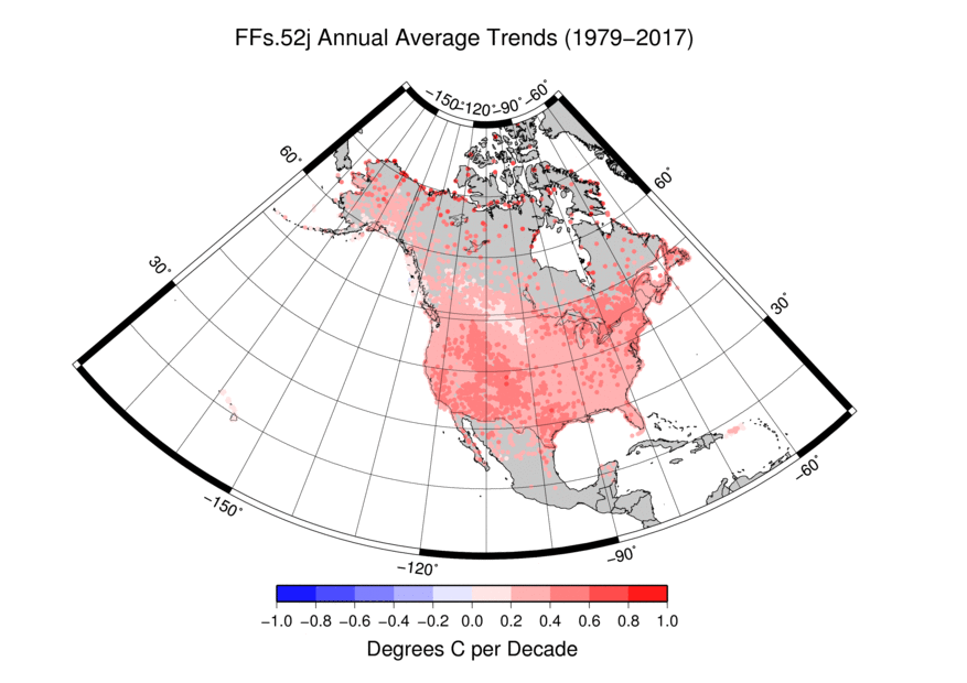 North American Annual Average Trends Map
The North American Dataset contains sets of Maximum, Minimum and Average Temperature data and Precipitation data that are either (1) raw (non-adjusted though flagged for possible quality issues), (2) adjusted due to time of observation bias (TOB) or (3) put through the Pairwise Homogenization Algorithm (PHA). These files contain North American stations and its data are measured in hundredths of degrees Celsius (without decimal place) for temperature and tenths of millimeters (without decimal place) for Precipitation. Each file includes the entire available Period of Record.
Dataset Citation
- Cite as: Menne, Matthew J.; Williams, Claude N. Jr.; Korzeniewski, Bryant (2017): North American Dataset, Version 1 [indicate subset used]. NOAA National Centers for Environmental Information. doi: 10.7289/V5348HN5 [indicate access date]
Dataset Identifiers
- doi:10.7289/V5348HN5
- NCEI DSI 6901_01
- gov.noaa.ncdc:C00949
ISO 19115-2 Metadata
gov.noaa.ncdc:C00949
| Download Data |
|
| Distribution Formats |
|
| Ordering Instructions | Contact NCEI for other distribution options and instructions. |
| Distributor |
NOAA National Centers for Environmental Information ncei.info@noaa.gov |
| Dataset Point of Contact | Customer Engagement Branch NOAA National Centers for Environmental Information 1-828-271-4800 ncei.orders@noaa.gov |
| Time Period | 1850-01-01 to Present (time interval: 1-month) |
| Spatial Bounding Box Coordinates |
West: -179.0
East: -55.0
South: 15.0
North: 72.0
|
| Spatial Coverage Map |
| General Documentation |
|
| Processing Documents |
| Publication Dates |
|
| Edition | Version 1 |
| Data Presentation Form | Digital table - digital representation of facts or figures systematically displayed, especially in columns |
| Dataset Progress Status | Ongoing - data is continually being updated |
| Data Update Frequency | Weekly |
| Purpose | This dataset is an input to other critical NCEI datasets monitoring climate. Because it incorporates all of North America, instead of just the United States, it has better coverage and can be incorporated into other global datasets. |
| Dataset Citation |
|
| Cited Authors |
|
| Principal Investigators |
|
| Collaborators |
|
| Publishers |
|
| Theme keywords |
Global Change Master Directory (GCMD) Science Keywords
|
| Data Center keywords |
Global Change Master Directory (GCMD) Data Center Keywords
|
| Platform keywords |
Global Change Master Directory (GCMD) Platform Keywords
|
| Instrument keywords |
Global Change Master Directory (GCMD) Instrument Keywords
|
| Place keywords |
Global Change Master Directory (GCMD) Location Keywords
|
| Project keywords |
Global Change Master Directory (GCMD) Project Keywords
|
| Data Resolution keywords |
Global Change Master Directory (GCMD) Temporal Data Resolution Keywords
|
| Stratum keywords |
Global Change Master Directory (GCMD) Location Keywords
|
| Use Constraints |
|
| Access Constraints |
|
| Fees |
|
| Lineage information for: dataset | |
|---|---|
| Lineage Statement | The data files for the NorthAm Dataset is generated through the GHCN-Monthly Process. This data has been the calibration dataset for USHCN since V2. |
| Processing Steps |
|
| Processing Documents | |
| Source Datasets |
|
| Lineage information for: repository | |
|---|---|
| Processing Steps |
|
Last Modified: 2023-06-23
For questions about the information on this page, please email: ncei.info@noaa.gov
For questions about the information on this page, please email: ncei.info@noaa.gov