United States Climate Reference Network (USCRN) Processed Data from the Version 2 USCRN Database
USCRN Database Version 2
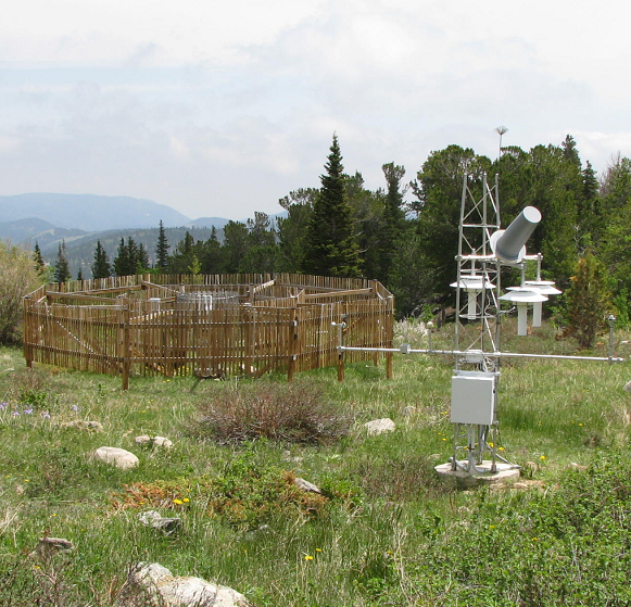 Station Picture
USCRN Processed data are interpreted values and derived geophysical parameters processed from raw data by the USCRN Team. Data were interpreted and ingested into a database, but are also available as netCDF files exported from the database. The "Version 2" of the dataset denotes the application of a new precipitation algorithm to calculate values. (See documentation for more information). Climate variable types include air temperature, precipitation, soil moisture, soil temperature, surface temperature, wetness, global solar radiation, relative humidity, and wind at 1.5 m above the ground. Many additional engineering variables are also available. These data have been decoded from the raw data streams, quality-flagged, and processed into level 1 hourly data (the only applied quality control is rounding some values as they enter the database), and includes additional calculated values such as precipitation (5-minute and hourly), hourly max/min temperature, average temperature (5-minute and hourly), soil moisture (volumetric water content, 5-minute values at the 5 cm depth and and hourly values at all depths) for all dielectric values in range, layer average soil moisture (5 minute and hourly), and layer average soil temperature (5 minute and hourly). It is the general practice of USCRN to not calculate derived variables if the input data to these calculations are flagged.
Dataset Citation
- Cite as: Palecki, M.A., J.H. Lawrimore, R.D. Leeper, J.E. Bell, S. Embler, and N. Casey (2015): U.S. Climate Reference Network Processed Data from USCRN Database Version 2 [indicate subset used]. NOAA National Centers for Environmental Information. doi:10.7289/V5MS3QR9 [indicate access date].
Dataset Identifiers
- doi:10.7289/V5MS3QR9
- NCEI DSI 3286_03
- gov.noaa.ncdc:C00959
ISO 19115-2 Metadata
gov.noaa.ncdc:C00959
| Other Access |
|
| Distribution Formats |
|
| Ordering Instructions | Contact NCEI for other distribution options and instructions. |
| Distributor |
NOAA National Centers for Environmental Information ncei.info@noaa.gov |
| Dataset Point of Contact | Customer Engagement Branch NOAA National Centers for Environmental Information 1-828-271-4800 ncei.orders@noaa.gov |
| Time Period | 2000-11-15 to Present (time interval: 1-hour) |
| Spatial Reference System | urn:ogc:def:crs:EPSG::4326 |
| Spatial Bounding Box Coordinates |
West: 172.0
East: -66.0
South: 18.0
North: 72.0
|
| Spatial Coverage Map |
| General Documentation |
|
| Associated Resources |
|
| Publication Dates |
|
| Edition | Version 2.1.1 |
| Data Presentation Form | Digital table - digital representation of facts or figures systematically displayed, especially in columns |
| Dataset Progress Status | Ongoing - data is continually being updated |
| Data Update Frequency | Daily |
| Supplemental Information | These data records are versioned based on the processing methods and algorithms used for the derivations. See documentation for more information. |
| Purpose | USCRN's primary goal is to provide future long-term homogeneous observations of temperature and precipitation that can be coupled to long-term historical observations for the detection and attribution of present and future climate change. Each station location is carefully selected to capture the representative climate regions of the nation. Data from the USCRN/USRCRN will be used in operational climate monitoring activities and for placing current climate anomalies into an historical perspective. These files are in an easy-to-use standard format that will ensure users from many different backgrounds will be able to use the data for research or climate understanding. |
| Use Limitations |
|
| Dataset Citation |
|
| Cited Authors |
|
| Originators |
|
| Principal Investigators |
|
| Collaborators |
|
| Publishers |
|
| Theme keywords |
Global Change Master Directory (GCMD) Science Keywords
|
| Data Center keywords |
Global Change Master Directory (GCMD) Data Center Keywords
|
| Platform keywords |
Global Change Master Directory (GCMD) Platform Keywords
|
| Instrument keywords |
Global Change Master Directory (GCMD) Instrument Keywords
|
| Place keywords |
Global Change Master Directory (GCMD) Location Keywords
|
| Project keywords |
Global Change Master Directory (GCMD) Project Keywords
|
| Data Resolution keywords |
Global Change Master Directory (GCMD) Horizontal Data Resolution Keywords
|
| Stratum keywords |
Global Change Master Directory (GCMD) Location Keywords
|
| Use Constraints |
|
| Access Constraints |
|
| Fees |
|
| Lineage information for: dataset | |
|---|---|
| Lineage Statement | Processed data are interpreted from raw satellite data which is transmitted by stations as a raw data stream to the NCEI, then the processed files are updated when new datalogger files are delivered. All data is passed through a basic Quality Assurance process, then flagged , if necessary. Some additional values are calculated from these interpreted values. See documentation for more information. |
| Processing Steps |
|
| Processing Environment | LRGS, Oracle database on Linux box |
| Source Datasets |
|
| Lineage information for: repository | |
|---|---|
| Processing Steps |
|
Last Modified: 2023-06-23
For questions about the information on this page, please email: ncei.info@noaa.gov
For questions about the information on this page, please email: ncei.info@noaa.gov