NOAA Climate Data Record (CDR) of MSU and AMSU-A Mean Layer Temperatures, UAH Version 6.0
Mean Layer Temperature - UAH
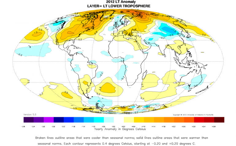 Image of Brightness Temperature Anomalies in the Lower Troposphere for 2012.
This dataset includes monthly gridded temperature anomalies on a global 2.5 x 2.5 degree grid derived from Microwave Sounding Unit (MSU) and Advanced Microwave Sounding Unit (AMSU) radiance data since December 1978. In addition, there are monthly regional anomalies and monthly mean annual cycle temperatures. All products are derived for four bulk layers of the atmosphere: the Lower Troposphere (TLT), Mid-Troposphere (TMT), Tropopause (TTP) and Lower Stratosphere (TLS). Version 6.0 is the latest UAH version archived at NOAA and is updated monthly. It utilizes the linear calibration equation with hot-target correction for the MSU series (TIROS-N through NOAA-14) rather than other non-linear calibration equations. Gridded values of absolute temperature are calculated from a polynomial fit in the vertical coordinate of all view angle temperatures binned into each grid over a month. The selected temperature is calculated from a prescribed view-angle where it intersects the polynomial fit of the temperature vs. view-angle relationship or each grid. The diurnal adjustment is completely empirical, calculated by comparing a diurnally-drifting spacecraft against one that is not drifting during their overlap comparison period (for a.m. spacecraft, NOAA-15 vs. (non-drifting) AQUA, and for p.m., NOAA-18 vs. (non-drifting) NOAA-19 during 4 years). The calculated diurnal relationship of temperature change vs. time of day is then applied to all drifting satellites. The Lower Troposphere is calculated from a linear combination of TMT, TTP and TLS rather than from a linear combination of view-angles from the single channel (MSU2 or AMSU5) as was done in versions 5.6 and earlier. A new bulk layer centered on the Tropopause was added in version 6.0. These products were converted from the native text file format to netCDF-4 following CF metadata conventions, and they are accompanied by algorithm documentation, data flow diagram and source code for the NOAA CDR Program.
- Cite this dataset when used as a source. John R. Christy, Roy W. Spencer, William D. Braswell, Kevin G. Doty, and NOAA CDR Program (2017): NOAA Climate Data Record (CDR) of MSU and AMSU-A Mean Layer Temperatures, UAH Version 6.0. [indicate subset used]. NOAA National Centers for Environmental Information. doi:10.7289/V5MC8X31 [access date].
| Download Data |
|
| Distribution Formats |
|
| Ordering Instructions |
Contact NCEI for other distribution options and instructions. |
| Distributor |
NOAA National Centers for Environmental Information
ncei.info@noaa.gov
|
| Dataset Point of Contact |
NOAA Climate Data Record Program Office
DOC/NOAA/NESDIS/NCEI > National Centers for Environmental Information, NESDIS, NOAA, U.S. Department of Commerce
+1 (828) 271-4800
uah_msu_contacts@noaa.gov
|
| Time Period |
1978-12-01 to Present (time interval: 1-month) |
| Spatial Bounding Box Coordinates |
West: -180.0
East: 180.0
South: -90.0
North: 90.0
|
| Spatial Coverage Map |
|
| General Documentation |
|
| Processing Documents |
- Source Code for Mean Layer Temperature - UAH
-
CDR Source Code (download)
This source code is for reference only. The source code is provided to maintain transparency of the algorithm and processes used in creating the Climate Data Record (CDR). The source code is not intended to be portable to any computer system(s) beyond that of the original CDR producer's environment.
- CDR Data Flow Diagram for Mean Layer Temperature - UAH
- Climate Algorithm Theoretical Basis Document (C-ATBD) for Mean Layer Temperature - UAH
|
| Associated Resources |
- Data Stewardship Maturity Report for NOAA Climate Data Record (CDR) of MSU and AMSU-A Mean Layer Temperatures, UAH Version 6.0
- Data Stewardship Maturity Report for NOAA Climate Data Record (CDR) of MSU and AMSU-A Mean Layer Temperatures, UAH Version 6.0
- UAH Version 6 global satellite temperature products: Methodology and results
- Other publications that cite this dataset
- NOAA Climate Data Record (CDR) of MSU and AMSU-A Mean Layer Temperatures, UAH Version 5.4 (Superseded)
|
| Publication Dates |
|
| Edition |
Version 6.0 |
| Data Presentation Form |
Digital image
|
| Dataset Progress Status |
Ongoing - data is continually being updated |
| Data Update Frequency |
Monthly |
| Purpose |
The Climate Data Record (CDR) of mean atmospheric layer temperature from MSU/AMSU-A is used for detection of possible trends in greenhouse warming, evaluation of computer models of climate change, and for understanding important factors in the climate system. |
| Use Limitations |
- See the Algorithm Theoretical Basis Document for a description of use limitations.
|
| Dataset Citation |
- Cite this dataset when used as a source. John R. Christy, Roy W. Spencer, William D. Braswell, Kevin G. Doty, and NOAA CDR Program (2017): NOAA Climate Data Record (CDR) of MSU and AMSU-A Mean Layer Temperatures, UAH Version 6.0. [indicate subset used]. NOAA National Centers for Environmental Information. doi:10.7289/V5MC8X31 [access date].
|
| Cited Authors |
- Christy, John R.
Earth System Science Center, University of Alabama in Huntsville
- Spencer, Roy W.
Earth System Science Center, University of Alabama in Huntsville
- Braswell, William D.
Earth System Science Center, University of Alabama in Huntsville
- Doty, Kevin G.
Earth System Science Center, University of Alabama in Huntsville
- NOAA CDR Program
|
| Principal Investigators |
- Christy, John R.
Earth System Science Center, University of Alabama in Huntsville
- Spencer, Roy W.
Earth System Science Center, University of Alabama in Huntsville
|
| Collaborators |
- Braswell, William D.
Earth System Science Center, University of Alabama in Huntsville
- Doty, Kevin G.
Earth System Science Center, University of Alabama in Huntsville
- NOAA CDR Program
|
| Publishers |
- DOC/NOAA/NESDIS/NCEI > National Centers for Environmental Information, NESDIS, NOAA, U.S. Department of Commerce
- DOC/NOAA/NESDIS/NCDC > National Climatic Data Center, NESDIS, NOAA, U.S. Department of Commerce
|
| Theme keywords |
Global Change Master Directory (GCMD) Science Keywords
- Earth Science > Spectral/Engineering > Microwave > Brightness Temperature
- Earth Science > Spectral/Engineering > Microwave > Temperature Anomalies
|
| Data Center keywords |
Global Change Master Directory (GCMD) Data Center Keywords
- DOC/NOAA/NESDIS/NCEI > National Centers for Environmental Information, NESDIS, NOAA, U.S. Department of Commerce
- DOC/NOAA/NESDIS/NCDC > National Climatic Data Center, NESDIS, NOAA, U.S. Department of Commerce
|
| Platform keywords |
Global Change Master Directory (GCMD) Platform Keywords
- TIROS-N > Television Infrared Observation Satellite-N
- NOAA-6 > National Oceanic & Atmospheric Administration - 6
- NOAA-7 > National Oceanic & Atmospheric Administration - 7
- NOAA-8 > National Oceanic & Atmospheric Administration - 8
- NOAA-9 > National Oceanic & Atmospheric Administration - 9
- NOAA-10 > National Oceanic & Atmospheric Administration - 10
- NOAA-11 > National Oceanic & Atmospheric Administration - 11
- NOAA-12 > National Oceanic & Atmospheric Administration - 12
- NOAA-14 > National Oceanic & Atmospheric Administration - 14
- NOAA-15 > National Oceanic & Atmospheric Administration - 15
- NOAA-18 > National Oceanic & Atmospheric Administration - 18
- NOAA-19 > National Oceanic & Atmospheric Administration - 19
- AQUA > Earth Observing System, AQUA
|
| Instrument keywords |
Global Change Master Directory (GCMD) Instrument Keywords
- AMSU-A > Advanced Microwave Sounding Unit-A
- MSU > Microwave Sounding Unit
|
| Place keywords |
Global Change Master Directory (GCMD) Location Keywords- Geographic Region > Global
|
| Project keywords |
Global Change Master Directory (GCMD) Project Keywords
|
| Stratum keywords |
Global Change Master Directory (GCMD) Location Keywords
- Vertical Location > Stratosphere
- Vertical Location > Troposphere
|
| Use Constraints |
- Cite this dataset when used as a source. John R. Christy, Roy W. Spencer, William D. Braswell, Kevin G. Doty, and NOAA CDR Program (2017): NOAA Climate Data Record (CDR) of MSU and AMSU-A Mean Layer Temperatures, UAH Version 6.0. [indicate subset used]. NOAA National Centers for Environmental Information. doi:10.7289/V5MC8X31 [access date].
- Publications using this dataset should also reference the following journal article: Spencer, R. W., Christy, J. R., & Braswell, W. D. (2017, February). UAH Version 6 global satellite temperature products: Methodology and results. Asia-Pacific Journal of Atmospheric Sciences. Springer Nature. https://doi.org/10.1007/s13143-017-0010-y
- See the Use Agreement for this CDR available on the CDR page.
- Use liability: NOAA and NCEI cannot provide any warranty as to the accuracy, reliability, or completeness of furnished data. Users assume responsibility to determine the usability of these data. The user is responsible for the results of any application of this data for other than its intended purpose.
|
| Access Constraints |
- Distribution liability: NOAA and NCEI make no warranty, expressed or implied, regarding these data, nor does the fact of distribution constitute such a warranty. NOAA and NCEI cannot assume liability for any damages caused by any errors or omissions in these data. If appropriate, NCEI can only certify that the data it distributes are an authentic copy of the records that were accepted for inclusion in the NCEI archives.
|
| Fees |
- In most cases, electronic downloads of the data are free. However, fees may apply for custom orders, data certifications, copies of analog materials, and data distribution on physical media.
|
| Lineage information for: repository |
|---|
| Processing Steps |
- 2015-04-22T00:00:00 - NOAA created the National Centers for Environmental Information (NCEI) by merging NOAA's National Climatic Data Center (NCDC), National Geophysical Data Center (NGDC), and National Oceanographic Data Center (NODC), including the National Coastal Data Development Center (NCDDC), per the Consolidated and Further Continuing Appropriations Act, 2015, Public Law 113-235. NCEI launched publicly on April 22, 2015.
|
| Acquisition Information (collection) |
|---|
| Instrument |
- MSU > Microwave Sounding Unit
- AMSU > Advanced Microwave Sounding Unit
|
| Platform |
- TIROS-N > Television Infrared Observation Satellite-N
- NOAA-6 > National Oceanic & Atmospheric Administration - 6
- NOAA-7 > National Oceanic & Atmospheric Administration - 7
- NOAA-8 > National Oceanic & Atmospheric Administration - 8
- NOAA-9 > National Oceanic & Atmospheric Administration - 9
- NOAA-10 > National Oceanic & Atmospheric Administration - 10
- NOAA-11 > National Oceanic & Atmospheric Administration - 11
- NOAA-12 > National Oceanic & Atmospheric Administration - 12
- NOAA-14 > National Oceanic & Atmospheric Administration - 14
- NOAA-15 > National Oceanic & Atmospheric Administration - 15
- NOAA-18 > National Oceanic & Atmospheric Administration - 18
- NOAA-19 > National Oceanic & Atmospheric Administration - 19
- AQUA > Earth Observing System, AQUA
|
Last Modified: 2023-08-10
For questions about the information on this page, please email:
ncei.info@noaa.gov