Gridded Satellite GOES (GridSat-GOES) East and West Full Disk and CONUS Coverage, Version 1
- referenceSystemInfo
- identificationInfo
- contentInfo
- contentInfo
- contentInfo
- contentInfo
- distributionInfo
- dataQualityInfo
- dataQualityInfo
- dataQualityInfo
- metadataMaintenance
(MI_Metadata)
fileIdentifier: gov.noaa.ncdc:C00993
language: eng; USA
characterSet: (MD_CharacterSetCode) utf8
hierarchyLevel: (MD_ScopeCode) dataset
contact: (CI_ResponsibleParty)
organisationName: NOAA National Centers for Environmental Information
contactInfo: (CI_Contact)
address: (CI_Address)
electronicMailAddress: ncei.info@noaa.gov
onlineResource: (CI_OnlineResource)
linkage: https://www.ncei.noaa.gov/contact
name: NCEI Contact Information
description: Information for contacts at NCEI.
function: (CI_OnLineFunctionCode) information
role: (CI_RoleCode) pointOfContact
dateStamp: 2023-06-23
metadataStandardName: ISO 19115-2 Geographic Information - Metadata - Part 2: Extensions for Imagery and Gridded Data
metadataStandardVersion: ISO 19115-2:2009(E)
return to top
referenceSystemInfo: (MD_ReferenceSystem)
referenceSystemIdentifier: (RS_Identifier)
authority: (CI_Citation)
title: EPSG Geodetic Parameter Dataset Registry
date: (CI_Date)
date: 2008-11-12
dateType: (CI_DateTypeCode) publication
citedResponsibleParty: (CI_ResponsibleParty)
organisationName: International Association of Oil and Gas Producers (OGP) Geomatics Committee
contactInfo: (CI_Contact)
onlineResource: (CI_OnlineResource)
linkage: http://www.epsg-registry.org/
applicationProfile: Data Search Application
name: EPSG Geodetic Parameter Dataset Registry Application
description: Interface to the EPSG Geodetic Parameter Dataset Registry
function: (CI_OnLineFunctionCode) search
role: (CI_RoleCode) custodian
citedResponsibleParty: (CI_ResponsibleParty)
organisationName: International Association of Oil and Gas Producers (OGP) Geomatics Committee
contactInfo: (CI_Contact)
onlineResource: (CI_OnlineResource)
linkage: http://www.epsg-registry.org/export.htm?gml=urn:ogc:def:crs:EPSG::4326
applicationProfile: Download
name: Coordinate Reference System data in GML
description: Coordinate Reference System data in GML
function: (CI_OnLineFunctionCode) download
role: (CI_RoleCode) custodian
code: urn:ogc:def:crs:EPSG::4326
version: (unknown)
return to top
identificationInfo: (MD_DataIdentification)
citation: (CI_Citation)
title: Gridded Satellite GOES (GridSat-GOES) East and West Full Disk and CONUS Coverage, Version 1
date: (CI_Date)
date: 2017-03-31
dateType: (CI_DateTypeCode) publication
edition: Version 1
identifier: (MD_Identifier)
code:
Anchor: DOI doi:10.7289/V5HM56GM
identifier: (MD_Identifier)
code: NCEI DSI 2013_01
identifier: (MD_Identifier)
code: gov.noaa.ncdc:C00993
citedResponsibleParty: (CI_ResponsibleParty)
organisationName: NOAA National Centers for Environmental Information
role: (CI_RoleCode) publisher
citedResponsibleParty: (CI_ResponsibleParty)
individualName: Knapp, Kenneth R.
organisationName: DOC/NOAA/NESDIS/NCEI > National Centers for Environmental Information, NESDIS, NOAA, U.S. Department of Commerce
role: (CI_RoleCode) principalInvestigator
citedResponsibleParty: (CI_ResponsibleParty)
individualName: Knapp, Kenneth R.
organisationName: DOC/NOAA/NESDIS/NCEI > National Centers for Environmental Information, NESDIS, NOAA, U.S. Department of Commerce
role: (CI_RoleCode) author
presentationForm: (CI_PresentationFormCode) imageDigital
abstract: The National Centers for Environmental Information in partnership with the Cooperative Institute for Climate and Satellites - North Carolina is reprocessing the GOES (Geostationary Operational Environmental Satellite) Variable (GVAR) period of record: 1994-2015. GridSat GOES represents a reformatted, remapped and calibrated GOES brightness temperatures and reflectance provided in Climate and Forecasting (CF)-compliant netCDF format. This is similar to the current GridSat-B1 CDR, but at a higher spatial and temporal resolution. The data are provided near the original spatial resolution of the infrared channels (4 km) on an equal angle grid (0.04 degrees). Data are mapped to a region spanning the view of GOES East and West (150 deg East to 5 deg East). The data are provided hourly, with all data mapping to the nearest hour. Currently, the data are limited to variables including the observations from the GOES satellites: 5 total channels. However, future efforts are planned to include some basic cloud information (cloud probability, temperature, etc.). Other possible updates include: improved coverage by expanding the GOES inventory (currently, gaps exist in the CLASS archive) and expand to the predecessor to the GOES Imager: GOES VISSR, which would expand coverage back to the 1980s.
purpose: This dataset is meant to provide access to GOES data to a wider community of users than the original GOES data. GOES GVAR has traditionally been available from CLASS as AREA files, which requires significant knowledge and expertise to use the data. GridSat GOES reformats and calibrates the data in order to simplify access.
status: (MD_ProgressCode) onGoing
pointOfContact: (CI_ResponsibleParty)
organisationName: DOC/NOAA/NESDIS/NCEI > National Centers for Environmental Information, NESDIS, NOAA, U.S. Department of Commerce
contactInfo: (CI_Contact)
address: (CI_Address)
electronicMailAddress: ncei.sat.info@noaa.gov
role: (CI_RoleCode) pointOfContact
resourceMaintenance: (MD_MaintenanceInformation)
maintenanceAndUpdateFrequency: (MD_MaintenanceFrequencyCode) continual
graphicOverview: (MD_BrowseGraphic)
fileName: https://www.ncei.noaa.gov/pub/data/metadata/images/C00993.png
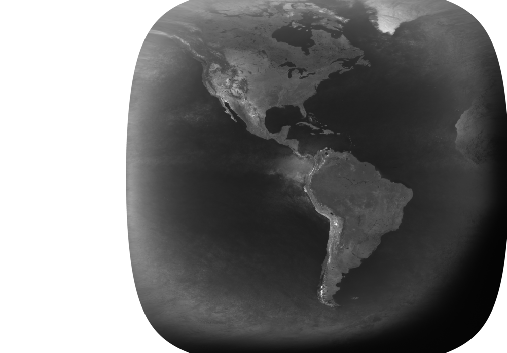
fileDescription: Grayscale GOES full disk composite imagery
fileType: PNG
descriptiveKeywords: (MD_Keywords)
keyword: Earth Science > Spectral/Engineering > Visible Wavelengths > Visible Imagery
keyword: Earth Science > Spectral/Engineering > Infrared Wavelengths > Infrared Imagery
keyword: Earth Science > Atmosphere > Atmospheric Water Vapor
keyword: Earth Science > Atmosphere > Atmospheric Radiation > Albedo
type: (MD_KeywordTypeCode) theme
thesaurusName: (CI_Citation)
title: Global Change Master Directory (GCMD) Science Keywords
date: (CI_Date)
date: 2018
dateType: (CI_DateTypeCode) revision
edition: Version 8.6
citedResponsibleParty: (CI_ResponsibleParty)
organisationName: Global Change Data Center, Science and Exploration Directorate, Goddard Space Flight Center (GSFC) National Aeronautics and Space Administration (NASA)
contactInfo: (CI_Contact)
onlineResource: (CI_OnlineResource)
linkage: https://earthdata.nasa.gov/about/gcmd/global-change-master-directory-gcmd-keywords
protocol: HTTPS
applicationProfile: Web Browser
name: Global Change Master Directory (GCMD) Keywords
description: The information provided on this page seeks to define how the GCMD Keywords are structured, used and accessed. It also provides information on how users can participate in the further development of the keywords.
function: (CI_OnLineFunctionCode) information
role: (CI_RoleCode) publisher
descriptiveKeywords: (MD_Keywords)
keyword: Atmospheric - Upper-air - Upper-air Water Vapour
type: (MD_KeywordTypeCode) theme
thesaurusName: (CI_Citation)
title: Global Climate Observing System (GCOS) Essential Climate Variables (ECVs)
date: (CI_Date)
date: 2017
dateType: (CI_DateTypeCode) publication
edition: Release 2017
citedResponsibleParty: (CI_ResponsibleParty)
organisationName: World Meteorological Organization, United Nations
contactInfo: (CI_Contact)
onlineResource: (CI_OnlineResource)
linkage: https://public.wmo.int/en/programmes/global-climate-observing-system/essential-climate-variables
protocol: HTTP
applicationProfile: Information
name: GCOS Essential Climate Variables
description: Overview of the GCOS Essential Climate Variables.
function: (CI_OnLineFunctionCode) information
role: (CI_RoleCode) custodian
descriptiveKeywords: (MD_Keywords)
keyword: Geographic Region > Western Hemisphere
keyword: Continent > North America > United States Of America
keyword: Geographic Region > Northern Hemisphere
keyword: Continent > North America > Canada
keyword: Continent > North America > United States Of America > Alaska
keyword: Ocean > Pacific Ocean > Central Pacific Ocean > Hawaiian Islands
type: (MD_KeywordTypeCode) place
thesaurusName: (CI_Citation)
title: Global Change Master Directory (GCMD) Location Keywords
date: (CI_Date)
date: 2018
dateType: (CI_DateTypeCode) revision
edition: Version 8.6
citedResponsibleParty: (CI_ResponsibleParty)
organisationName: Global Change Data Center, Science and Exploration Directorate, Goddard Space Flight Center (GSFC) National Aeronautics and Space Administration (NASA)
contactInfo: (CI_Contact)
onlineResource: (CI_OnlineResource)
linkage: https://earthdata.nasa.gov/about/gcmd/global-change-master-directory-gcmd-keywords
protocol: HTTPS
applicationProfile: Web Browser
name: Global Change Master Directory (GCMD) Keywords
description: The information provided on this page seeks to define how the GCMD Keywords are structured, used and accessed. It also provides information on how users can participate in the further development of the keywords.
function: (CI_OnLineFunctionCode) information
role: (CI_RoleCode) publisher
descriptiveKeywords: (MD_Keywords)
keyword: Vertical Location > Troposphere
type: (MD_KeywordTypeCode) stratum
thesaurusName: (CI_Citation)
title: Global Change Master Directory (GCMD) Location Keywords
date: (CI_Date)
date: 2018
dateType: (CI_DateTypeCode) revision
edition: Version 8.6
citedResponsibleParty: (CI_ResponsibleParty)
organisationName: Global Change Data Center, Science and Exploration Directorate, Goddard Space Flight Center (GSFC) National Aeronautics and Space Administration (NASA)
contactInfo: (CI_Contact)
onlineResource: (CI_OnlineResource)
linkage: https://earthdata.nasa.gov/about/gcmd/global-change-master-directory-gcmd-keywords
protocol: HTTPS
applicationProfile: Web Browser
name: Global Change Master Directory (GCMD) Keywords
description: The information provided on this page seeks to define how the GCMD Keywords are structured, used and accessed. It also provides information on how users can participate in the further development of the keywords.
function: (CI_OnLineFunctionCode) information
role: (CI_RoleCode) publisher
descriptiveKeywords: (MD_Keywords)
keyword: NOAA OneStop Project
type: (MD_KeywordTypeCode) project
thesaurusName: (CI_Citation)
title: Global Change Master Directory (GCMD) Project Keywords
date: (CI_Date)
date: 2018
dateType: (CI_DateTypeCode) revision
edition: Version 8.6
citedResponsibleParty: (CI_ResponsibleParty)
organisationName: Global Change Data Center, Science and Exploration Directorate, Goddard Space Flight Center (GSFC) National Aeronautics and Space Administration (NASA)
contactInfo: (CI_Contact)
onlineResource: (CI_OnlineResource)
linkage: https://earthdata.nasa.gov/about/gcmd/global-change-master-directory-gcmd-keywords
protocol: HTTPS
applicationProfile: Web Browser
name: Global Change Master Directory (GCMD) Keywords
description: The information provided on this page seeks to define how the GCMD Keywords are structured, used and accessed. It also provides information on how users can participate in the further development of the keywords.
function: (CI_OnLineFunctionCode) information
role: (CI_RoleCode) publisher
descriptiveKeywords: (MD_Keywords)
keyword: GOES I-M Imager
keyword: GOES N-P Imager
type: (MD_KeywordTypeCode) instrument
thesaurusName: (CI_Citation)
title: Global Change Master Directory (GCMD) Instrument Keywords
date: (CI_Date)
date: 2018
dateType: (CI_DateTypeCode) revision
edition: Version 8.6
citedResponsibleParty: (CI_ResponsibleParty)
organisationName: Global Change Data Center, Science and Exploration Directorate, Goddard Space Flight Center (GSFC) National Aeronautics and Space Administration (NASA)
contactInfo: (CI_Contact)
onlineResource: (CI_OnlineResource)
linkage: https://earthdata.nasa.gov/about/gcmd/global-change-master-directory-gcmd-keywords
protocol: HTTPS
applicationProfile: Web Browser
name: Global Change Master Directory (GCMD) Keywords
description: The information provided on this page seeks to define how the GCMD Keywords are structured, used and accessed. It also provides information on how users can participate in the further development of the keywords.
function: (CI_OnLineFunctionCode) information
role: (CI_RoleCode) publisher
descriptiveKeywords: (MD_Keywords)
keyword: GOES-8 > Geostationary Operational Environmental Satellite 8
keyword: GOES-9 > Geostationary Operational Environmental Satellite 9
keyword: GOES-10 > Geostationary Operational Environmental Satellite 10
keyword: GOES-11 > Geostationary Operational Environmental Satellite 11
keyword: GOES-12 > Geostationary Operational Environmental Satellite 12
keyword: GOES-13 > Geostationary Operational Environmental Satellite 13
keyword: GOES-14 > Geostationary Operational Environmental Satellite 14
keyword: GOES-15 > Geostationary Operational Environmental Satellite 15
type: (MD_KeywordTypeCode) platform
thesaurusName: (CI_Citation)
title: Global Change Master Directory (GCMD) Platform Keywords
date: (CI_Date)
date: 2018
dateType: (CI_DateTypeCode) revision
edition: Version 8.6
citedResponsibleParty: (CI_ResponsibleParty)
organisationName: Global Change Data Center, Science and Exploration Directorate, Goddard Space Flight Center (GSFC) National Aeronautics and Space Administration (NASA)
contactInfo: (CI_Contact)
onlineResource: (CI_OnlineResource)
linkage: https://earthdata.nasa.gov/about/gcmd/global-change-master-directory-gcmd-keywords
protocol: HTTPS
applicationProfile: Web Browser
name: Global Change Master Directory (GCMD) Keywords
description: The information provided on this page seeks to define how the GCMD Keywords are structured, used and accessed. It also provides information on how users can participate in the further development of the keywords.
function: (CI_OnLineFunctionCode) information
role: (CI_RoleCode) publisher
descriptiveKeywords: (MD_Keywords)
keyword: 1 km - < 10 km or approximately .01 degree - < .09 degree
type: (MD_KeywordTypeCode) dataResolution
thesaurusName: (CI_Citation)
title: Global Change Master Directory (GCMD) Horizontal Data Resolution Keywords
date: (CI_Date)
date: 2018
dateType: (CI_DateTypeCode) revision
edition: Version 8.6
citedResponsibleParty: (CI_ResponsibleParty)
organisationName: Global Change Data Center, Science and Exploration Directorate, Goddard Space Flight Center (GSFC) National Aeronautics and Space Administration (NASA)
contactInfo: (CI_Contact)
onlineResource: (CI_OnlineResource)
linkage: https://earthdata.nasa.gov/about/gcmd/global-change-master-directory-gcmd-keywords
protocol: HTTPS
applicationProfile: Web Browser
name: Global Change Master Directory (GCMD) Keywords
description: The information provided on this page seeks to define how the GCMD Keywords are structured, used and accessed. It also provides information on how users can participate in the further development of the keywords.
function: (CI_OnLineFunctionCode) information
role: (CI_RoleCode) publisher
descriptiveKeywords: (MD_Keywords)
keyword: DOC/NOAA/NESDIS/NCDC > National Climatic Data Center, NESDIS, NOAA, U.S. Department of Commerce
keyword: DOC/NOAA/NESDIS/NCEI > National Centers for Environmental Information, NESDIS, NOAA, U.S. Department of Commerce
keyword: DOC/NOAA/NESDIS/OSPO > Office of Satellite and Product Operations, NESDIS, NOAA, U.S. Department of Commerce
type: (MD_KeywordTypeCode) dataCentre
thesaurusName: (CI_Citation)
title: Global Change Master Directory (GCMD) Data Center Keywords
date: (CI_Date)
date: 2018
dateType: (CI_DateTypeCode) revision
edition: Version 8.6
citedResponsibleParty: (CI_ResponsibleParty)
organisationName: Global Change Data Center, Science and Exploration Directorate, Goddard Space Flight Center (GSFC) National Aeronautics and Space Administration (NASA)
contactInfo: (CI_Contact)
onlineResource: (CI_OnlineResource)
linkage: https://earthdata.nasa.gov/about/gcmd/global-change-master-directory-gcmd-keywords
protocol: HTTPS
applicationProfile: Web Browser
name: Global Change Master Directory (GCMD) Keywords
description: The information provided on this page seeks to define how the GCMD Keywords are structured, used and accessed. It also provides information on how users can participate in the further development of the keywords.
function: (CI_OnLineFunctionCode) information
role: (CI_RoleCode) publisher
resourceConstraints: (MD_Constraints)
useLimitation: Data are at 4km resolution, which means users needing full resolution visible imagery (1 km) will need to use GOES data from CLASS. Data are at the nearest hourly time slot. Hence, any need for data at higher temporal scales will need to access GOES data from CLASS.
resourceConstraints: (MD_LegalConstraints)
useConstraints: (MD_RestrictionCode) otherRestrictions
otherConstraints: Cite as: Knapp, Kenneth R. (2017): Gridded Satellite GOES Coverage Data (GridSat-GOES) [indicate subset used]. NOAA National Centers for Environmental Information. doi:10.7289/V5HM56GM [access date].
resourceConstraints: (MD_LegalConstraints)
accessConstraints: (MD_RestrictionCode) otherRestrictions
otherConstraints: Distribution liability: NOAA and NCEI make no warranty, expressed or implied, regarding these data, nor does the fact of distribution constitute such a warranty. NOAA and NCEI cannot assume liability for any damages caused by any errors or omissions in these data. If appropriate, NCEI can only certify that the data it distributes are an authentic copy of the records that were accepted for inclusion in the NCEI archives.
resourceConstraints: (MD_LegalConstraints)
useConstraints: (MD_RestrictionCode) otherRestrictions
otherConstraints: Use liability: NOAA and NCEI cannot provide any warranty as to the accuracy, reliability, or completeness of furnished data. Users assume responsibility to determine the usability of these data. The user is responsible for the results of any application of this data for other than its intended purpose.
aggregationInfo: (MD_AggregateInformation)
aggregateDataSetName: (CI_Citation)
title: Data Stewardship Maturity Report for Gridded Satellite GOES Coverage Data (GridSat-GOES)
date: (CI_Date)
date: 2022
dateType: (CI_DateTypeCode) publication
citedResponsibleParty: (CI_ResponsibleParty)
individualName: NOAA Institutional Repository
role: (CI_RoleCode) publisher
citedResponsibleParty: (CI_ResponsibleParty)
organisationName: (missing)
contactInfo: (CI_Contact)
onlineResource: (CI_OnlineResource)
linkage: https://doi.org/10.25923/r2af-gc42
protocol: HTTPS
applicationProfile: Web Browser
name: DSMR Publication at the NOAA Institutional Repository
description: Report documenting the Scientific Data Stewardship Maturity for this dataset.
function: (CI_OnLineFunctionCode) information
role: (inapplicable)
associationType: (DS_AssociationTypeCode) crossReference
initiativeType: (DS_InitiativeTypeCode) sciencePaper
aggregationInfo: (MD_AggregateInformation)
aggregateDataSetName: (CI_Citation)
title: Data Stewardship Maturity Report for Gridded Satellite GOES Coverage Data (GridSat-GOES)
date: (CI_Date)
date: 2021
dateType: (CI_DateTypeCode) publication
citedResponsibleParty: (CI_ResponsibleParty)
individualName: NOAA Institutional Repository
role: (CI_RoleCode) publisher
citedResponsibleParty: (CI_ResponsibleParty)
organisationName: (missing)
contactInfo: (CI_Contact)
onlineResource: (CI_OnlineResource)
linkage: https://doi.org/10.25923/r2af-gc42
protocol: HTTPS
applicationProfile: Web Browser
name: DSMR Publication at the NOAA Institutional Repository
description: Report documenting the Scientific Data Stewardship Maturity for this dataset.
function: (CI_OnLineFunctionCode) information
role: (inapplicable)
associationType: (DS_AssociationTypeCode) crossReference
initiativeType: (DS_InitiativeTypeCode) sciencePaper
aggregationInfo: (MD_AggregateInformation)
aggregateDataSetName: (CI_Citation)
title: GOES I-M DataBook
date: (CI_Date)
date: 1996-08-31
dateType: (CI_DateTypeCode) publication
edition: Revision 1
identifier: (MD_Identifier)
code: DRL 101-08
citedResponsibleParty: (CI_ResponsibleParty)
organisationName: SS/L > Space Systems-Loral
role: (CI_RoleCode) publisher
citedResponsibleParty: (CI_ResponsibleParty)
organisationName: (missing)
contactInfo: (CI_Contact)
onlineResource: (CI_OnlineResource)
linkage: https://goes.gsfc.nasa.gov/text/goes.databook.html
protocol: HTTPS
applicationProfile: Web Browser
name: GOES I-M DataBook
description: A summary and technical overview of the GOES I-M system, its satellites, subsystems, sensor suite, and associated ground communication and data handling subsystems.
function: (CI_OnLineFunctionCode) information
role: (missing)
associationType: (DS_AssociationTypeCode) crossReference
initiativeType: (DS_InitiativeTypeCode) userGuide
aggregationInfo: (MD_AggregateInformation)
aggregateDataSetName: (CI_Citation)
title: GOES N DataBook
date: (CI_Date)
date: 2005-02-28
dateType: (CI_DateTypeCode) publication
edition: Revision B
identifier: (MD_Identifier)
code: CDRL PM-1-1-03
citedResponsibleParty: (CI_ResponsibleParty)
organisationName: Boeing
role: (CI_RoleCode) publisher
citedResponsibleParty: (CI_ResponsibleParty)
organisationName: (missing)
contactInfo: (CI_Contact)
onlineResource: (CI_OnlineResource)
linkage: https://goes.gsfc.nasa.gov/text/goes.databookn.html
protocol: HTTPS
applicationProfile: Web Browser
name: GOES N DataBook
description: A summary and technical overview of the GOES N-P system, its satellites, subsystems, sensor suite, and associated ground communication and data handling subsystems.
function: (CI_OnLineFunctionCode) information
role: (missing)
associationType: (DS_AssociationTypeCode) crossReference
initiativeType: (DS_InitiativeTypeCode) userGuide
aggregationInfo: (MD_AggregateInformation)
aggregateDataSetName: (CI_Citation)
title: Gridded Satellite (GridSat) GOES and CONUS Data
date: (CI_Date)
date: 2018-08-06
dateType: (CI_DateTypeCode) publication
identifier: (MD_Identifier)
code: doi:10.5194/essd-10-1417-2018
citedResponsibleParty: (CI_ResponsibleParty)
organisationName: Copernicus Publications
role: (CI_RoleCode) publisher
citedResponsibleParty: (CI_ResponsibleParty)
organisationName: (missing)
contactInfo: (CI_Contact)
onlineResource: (CI_OnlineResource)
linkage: https://doi.org/10.5194/essd-10-1417-2018
protocol: HTTPS
applicationProfile: Web Browser
name: Journal article published August 2018 by Copernicus Publications (Earth System Science Data).
description: Knapp, K. R., Wilkins, S., (2018), Gridded Satellite (GridSat) GOES and CONUS Data, Earth System Science Data, 10, 1417-1425, doi:10.5194/essd-10-1417-2018.
function: (CI_OnLineFunctionCode) information
role: (missing)
associationType: (DS_AssociationTypeCode) crossReference
initiativeType: (DS_InitiativeTypeCode) sciencePaper
spatialRepresentationType: (MD_SpatialRepresentationTypeCode) grid
spatialResolution: (MD_Resolution)
distance:
Distance: 4000
language: eng; USA
topicCategory: (MD_TopicCategoryCode) climatologyMeteorologyAtmosphere
extent: (EX_Extent)
geographicElement: (EX_GeographicBoundingBox)
extentTypeCode: 1
westBoundLongitude: -150.0
eastBoundLongitude: -5.0
southBoundLatitude: -75.0
northBoundLatitude: 75.0
temporalElement: (EX_TemporalExtent)
extent:
TimePeriod:
description: ground condition
beginPosition: 1994-10-01
endPosition:
timeInterval: 1
return to top
contentInfo: (MI_CoverageDescription)
attributeDescription:
RecordType: GridSat-CONUS.goes13.YYYY.MM.DD.TTTT.v01.nc
contentType: (MD_CoverageContentTypeCode) coordinate
dimension: (MD_Band)
sequenceIdentifier:
MemberName:
aName: lat
attributeType:
TypeName:
aName: float
descriptor: Latitude (latitude)
units: http://example.org/someUnitsDictionary.xml#degrees_north
dimension: (MD_Band)
sequenceIdentifier:
MemberName:
aName: lon
attributeType:
TypeName:
aName: float
descriptor: Longitude (longitude)
units: http://example.org/someUnitsDictionary.xml#degrees_east
dimension: (MD_Band)
sequenceIdentifier:
MemberName:
aName: time
attributeType:
TypeName:
aName: double
descriptor: time (time)
units: http://example.org/someUnitsDictionary.xml#days%20since%201970-01-01%2000%3A00%3A00
return to top
contentInfo: (MI_CoverageDescription)
attributeDescription: (unknown)
contentType: (MD_CoverageContentTypeCode) auxiliaryInformation
dimension: (MD_Band)
sequenceIdentifier:
MemberName:
aName: satlat
attributeType:
TypeName:
aName: float
descriptor: Sub-Satellite Latitude
units: http://example.org/someUnitsDictionary.xml#degrees_north
dimension: (MD_Band)
sequenceIdentifier:
MemberName:
aName: satlon
attributeType:
TypeName:
aName: float
descriptor: Sub-Satellite Longitude
units: http://example.org/someUnitsDictionary.xml#degrees_east
dimension: (MD_Band)
sequenceIdentifier:
MemberName:
aName: satrad
attributeType:
TypeName:
aName: float
descriptor: Sub-Satellite Orbital Radius
units: http://example.org/someUnitsDictionary.xml#km
dimension: (MD_Band)
sequenceIdentifier:
MemberName:
aName: filename
attributeType:
TypeName:
aName: char
descriptor: CLASS filenames
dimension: (MD_Band)
sequenceIdentifier:
MemberName:
aName: delta_time
attributeType:
TypeName:
aName: byte
descriptor: Difference between optimal grid time and pixel observation
units: http://example.org/someUnitsDictionary.xml#minutes
return to top
contentInfo: (MI_CoverageDescription)
attributeDescription: (unknown)
contentType: (MD_CoverageContentTypeCode) physicalMeasurement
dimension: (MD_Band)
sequenceIdentifier:
MemberName:
aName: ch1
attributeType:
TypeName:
aName: short
descriptor: Visible channel reflectance
units: http://example.org/someUnitsDictionary.xml#1
dimension: (MD_Band)
sequenceIdentifier:
MemberName:
aName: ch2
attributeType:
TypeName:
aName: short
descriptor: Channel 2 Brightness Temperature (toa_brightness_temperature)
units: http://example.org/someUnitsDictionary.xml#Kelvin
dimension: (MD_Band)
sequenceIdentifier:
MemberName:
aName: ch3
attributeType:
TypeName:
aName: short
descriptor: Channel 3 Brightness Temperature (toa_brightness_temperature)
units: http://example.org/someUnitsDictionary.xml#Kelvin
dimension: (MD_Band)
sequenceIdentifier:
MemberName:
aName: ch4
attributeType:
TypeName:
aName: short
descriptor: Channel 4 Brightness Temperature (toa_brightness_temperature)
units: http://example.org/someUnitsDictionary.xml#Kelvin
dimension: (MD_Band)
sequenceIdentifier:
MemberName:
aName: ch5
attributeType:
TypeName:
aName: short
descriptor: Channel 5 Brightness Temperature (toa_brightness_temperature)
units: http://example.org/someUnitsDictionary.xml#Kelvin
dimension: (MD_Band)
sequenceIdentifier:
MemberName:
aName: ch6
attributeType:
TypeName:
aName: short
descriptor: Channel 6 Brightness Temperature (toa_brightness_temperature)
units: http://example.org/someUnitsDictionary.xml#Kelvin
dimension: (MD_Band)
sequenceIdentifier:
MemberName:
aName: ch1v
attributeType:
TypeName:
aName: byte
descriptor: Channel 1 variability (spatial std deviation of 3x3 at full res)
units: http://example.org/someUnitsDictionary.xml#1
dimension: (MD_Band)
sequenceIdentifier:
MemberName:
aName: ch4v
attributeType:
TypeName:
aName: byte
descriptor: Channel 4 variability (spatial std deviation of 3x3)
units: http://example.org/someUnitsDictionary.xml#Kelvin
return to top
contentInfo: (MI_CoverageDescription)
attributeDescription: (unknown)
contentType: (unknown)
dimension: (MD_Band)
sequenceIdentifier:
MemberName:
aName: lat_bounds
attributeType:
TypeName:
aName: float
descriptor: Latitude bounds
units: http://example.org/someUnitsDictionary.xml#degrees_north
dimension: (MD_Band)
sequenceIdentifier:
MemberName:
aName: lon_bounds
attributeType:
TypeName:
aName: float
descriptor: Longitude bounds
units: http://example.org/someUnitsDictionary.xml#degrees_east
dimension: (MD_Band)
sequenceIdentifier:
MemberName:
aName: time_bounds
attributeType:
TypeName:
aName: double
descriptor: Temporal bounds
units: http://example.org/someUnitsDictionary.xml#days%20since%201970-01-01%2000%3A00%3A00
return to top
distributionInfo: (MD_Distribution)
distributor: (MD_Distributor)
distributorContact: (CI_ResponsibleParty)
organisationName: NOAA National Centers for Environmental Information
contactInfo: (CI_Contact)
address: (CI_Address)
electronicMailAddress: ncei.info@noaa.gov
onlineResource: (CI_OnlineResource)
linkage: https://www.ncei.noaa.gov/contact
name: NCEI Contact Information
description: Information for contacts at NCEI.
function: (CI_OnLineFunctionCode) information
role: (CI_RoleCode) distributor
distributionOrderProcess: (MD_StandardOrderProcess)
fees: In most cases, electronic downloads of the data are free. However, fees may apply for custom orders, data certifications, copies of analog materials, and data distribution on physical media.
orderingInstructions: Contact NCEI for other distribution options and instructions.
distributorFormat: (MD_Format)
name: XML
version: (missing)
distributorFormat: (MD_Format)
name: netCDF-4
version: 4
distributorTransferOptions: (MD_DigitalTransferOptions)
onLine: (CI_OnlineResource)
linkage: https://doi.org/10.7289/V5HM56GM
protocol: HTTPS
applicationProfile: Landing Page
name: NCEI Dataset Landing Page
description: Landing page for the dataset.
function: (CI_OnLineFunctionCode) information
distributorTransferOptions: (MD_DigitalTransferOptions)
transferSize:
Real: 77
onLine: (CI_OnlineResource)
linkage: https://www.ncei.noaa.gov/data/gridsat-goes/
protocol: HTTPS
applicationProfile: Download
name: NOAA NCEI Direct Download
description: Access and download data files by date.
function: (CI_OnLineFunctionCode) download
return to top
dataQualityInfo: (DQ_DataQuality)
scope: (DQ_Scope)
level: (MD_ScopeCode) dataset
extent: #boundingExtent
lineage: (LI_Lineage)
statement: The data were produced by and are archived at the NOAA National Centers for Environmental Information (NCEI).
processStep: (LE_ProcessStep)
description: Read GOES data, navigating and calibrating, and store on appropriate GridSat grids (in netCDF).
rationale: This is the only step in the processing. The routine reads the GOES data file (obtained from NOAA CLASS). Based on the observation time, the appropriate GridSat time is selected and data are stored if they are the closest observation to the optimal grid time (hourly for GOES and 15-min for CONUS).
dateTime: (missing)
processor: (CI_ResponsibleParty)
organisationName: DOC/NOAA/NESDIS/NCEI > National Centers for Environmental Information, NESDIS, NOAA, U.S. Department of Commerce
role: (CI_RoleCode) processor
source: sd001
processingInformation: (LE_Processing)
identifier: (MD_Identifier)
code: IDL routine
source: (LE_Source)
description: GOES Satellite Data - Imager (GVAR_IMG)
sourceCitation: (CI_Citation)
title: GOES Satellite Data - Imager (GVAR_IMG)
date: (CI_Date)
date: 1994-08-31
dateType: (CI_DateTypeCode) publication
citedResponsibleParty: (CI_ResponsibleParty)
organisationName: DOC/NOAA/NESDIS/NCEI > National Centers for Environmental Information, NESDIS, NOAA, U.S. Department of Commerce
role: (CI_RoleCode) distributor
citedResponsibleParty: (CI_ResponsibleParty)
organisationName: (missing)
contactInfo: (CI_Contact)
onlineResource: (CI_OnlineResource)
linkage: https://www.class.noaa.gov/saa/products/search?sub_id=0&datatype_family=GVAR_IMG&submit.x=18&submit.y=11
applicationProfile: Web Browser
name: GOES Satellite Data - Imager (GVAR_IMG)
description: Landing page for the source dataset
function: (CI_OnLineFunctionCode) information
role: (missing)
sourceExtent: (EX_Extent)
geographicElement: (EX_GeographicBoundingBox)
extentTypeCode: 1
westBoundLongitude: -150
eastBoundLongitude: -5
southBoundLatitude: -75
northBoundLatitude: 75
temporalElement: (EX_TemporalExtent)
extent:
TimePeriod:
beginPosition: 1994-08-31
endPosition:
sourceStep: ps001
return to top
dataQualityInfo: (DQ_DataQuality)
scope: (DQ_Scope)
level: (MD_ScopeCode) repository
levelDescription: (MD_ScopeDescription)
other: NOAA National Centers for Environmental Information
lineage: (LI_Lineage)
processStep: (LE_ProcessStep)
description: NOAA created the National Centers for Environmental Information (NCEI) by merging NOAA's National Climatic Data Center (NCDC), National Geophysical Data Center (NGDC), and National Oceanographic Data Center (NODC), including the National Coastal Data Development Center (NCDDC), per the Consolidated and Further Continuing Appropriations Act, 2015, Public Law 113-235. NCEI launched publicly on April 22, 2015.
dateTime:
DateTime: 2015-04-22T00:00:00
return to top
dataQualityInfo: (DQ_DataQuality)
scope: (DQ_Scope)
level: (MD_ScopeCode) dataset
levelDescription: (MD_ScopeDescription)
other: Data Stewardship
report: (DQ_ConceptualConsistency)
nameOfMeasure: Data Stewardship Maturity Assessment
measureIdentification: (MD_Identifier)
code: MM-Stew
measureDescription: The Data Stewardship Maturity Matrix (DSMM) is a unified framework that defines criteria for each of nine components based on measurable practices, which can be used to apply a progressive, 6-level rating to an individual dataset, representing stewardship maturity stages rated as Not Assessed or Not Available (Level 0), adHoc (Level 1), minimum (Level 2), intermediate (Level 3), advanced (Level 4), and optimal (Level 5).
evaluationMethodDescription: Data Stewardship Maturity Assessment was evaluated by the metadata content editor for the NOAA OneStop project using the Scientific Data Stewardship Maturity Assessment Model Template v4.0.
evaluationProcedure: (CI_Citation)
title: The Scientific Data Stewardship Maturity Assessment Model Template
date: (CI_Date)
date: 2017-03-06
dateType: (CI_DateTypeCode) publication
edition: NCDC-CICS-SMM_0001_Rev.1 v4.0 03/06/2017
identifier: (MD_Identifier)
code:
Anchor: DOI link doi:10.10.6084/m9.figshare.1211954
citedResponsibleParty: (CI_ResponsibleParty)
individualName: Peng, Ge
organisationName: CICS-NC/NCEI
role: (CI_RoleCode) author
citedResponsibleParty: (CI_ResponsibleParty)
organisationName: (inapplicable)
contactInfo: (CI_Contact)
onlineResource: (CI_OnlineResource)
linkage: https://doi.org/10.6084/m9.figshare.1211954
protocol: HTTPS
applicationProfile: Web Browser
name: The Scientific Data Stewardship Maturity Assessment Model Template
description: Landing page for quality evaluation procedure.
function: (CI_OnLineFunctionCode) information
role: (inapplicable)
dateTime:
DateTime: 2017-03-06T00:00:00
result: (DQ_QuantitativeResult)
valueUnit: (inapplicable)
value:
Record:
CodeListValue: adHoc
value:
Record:
CodeListValue: advanced
value:
Record:
CodeListValue: adHoc
value:
Record:
CodeListValue: advanced
value:
Record:
CodeListValue: advanced
value:
Record:
CodeListValue: advanced
value:
Record:
CodeListValue: adHoc
value:
Record:
CodeListValue: minimal
value:
Record:
CodeListValue: minimal
return to top
metadataMaintenance: (MD_MaintenanceInformation)
maintenanceAndUpdateFrequency: (MD_MaintenanceFrequencyCode) asNeeded
maintenanceNote: Bulk metadata change applied on 2023-06-23. See version control repository history for metadata change details.