Water Level Station History
EV2 - Water Level Station History Imaging
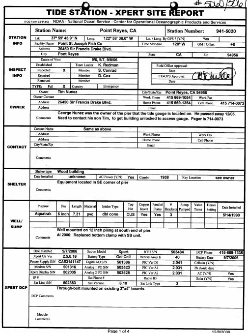 Image example
Images contain station history information for 175 stations in the National Water Level Observation Network (NWLON). The NWLON is a network of long-term, continuously operating water-level stations throughout the USA, including its island possessions and territories and the Great Lakes. NWLON stations are the foundation for reference stations for NOAA's tide prediction products, and serve as controls in determining tidal datums for all short-term water-level stations. Additional histories for approximately 6,000 secondary and tertiary stations are also included, but are likely incomplete due to defunding of the task prior to completion. Images created through a Climate Database Modernization Program task in partnership with NOAA's National Ocean Service, Center for Operational Oceanographic Products and Services (CO-OPS)/Requirements and Development Devision. The task leader was oceanographer Thomas F. Landon, and then Manoj R. Samant. Scanning began with a pilot in fall 2003, and continued through early 2011.
Dataset Citation
Cite this dataset when used as a source.
Dataset Identifiers
- NCEI DSI 3900_01
- gov.noaa.ncdc:C01078
ISO 19115-2 Metadata
gov.noaa.ncdc:C01078
| Download Data |
|
| Distribution Formats |
|
| Ordering Instructions | Contact NCEI for other distribution options and instructions. |
| Distributor |
NOAA National Centers for Environmental Information ncei.info@noaa.gov |
| Dataset Point of Contact | Jason Cooper NCDC Archivist DOC/NOAA/NESDIS/NCEI > National Centers for Environmental Information, NESDIS, NOAA, U.S. Department of Commerce +1 828-271-4800 ncei.orders@noaa.gov |
| Coverage Description | |
| Time Period | 1850 to 2011 |
| Spatial Bounding Box Coordinates |
West: 172
East: -65
South: 18
North: 72
|
| Spatial Coverage Map |
| Dataset Information |
|
| General Documentation |
|
| Publication Dates |
|
| Data Presentation Form | Digital image |
| Dataset Progress Status | Complete - production of the data has been completed |
| Data Update Frequency | Irregular |
| Purpose | In the late 1990s NCDC realized the need to host digital images of weather and climate records on the internet. As a result, EV2 was developed as a key system for providing access to the millions of original source data images in the NCDC archives. With its upload and index capability, EV2 also enables the continuation of NCDC's commitment to make more of its weather and climate data available online so that users across the world can view climate and weather records held in the NCDC archives. |
| Use Limitations |
|
| Publishers |
|
| Theme keywords |
|
| Data Center keywords |
Global Change Master Directory (GCMD) Data Center Keywords
|
| Platform keywords |
Global Change Master Directory (GCMD) Platform Keywords
|
| Place keywords |
Global Change Master Directory (GCMD) Location Keywords
|
| Stratum keywords |
Global Change Master Directory (GCMD) Location Keywords
|
| Use Constraints |
|
| Access Constraints |
|
| Fees |
|
| Lineage information for: repository | |
|---|---|
| Processing Steps |
|
Last Modified: 2023-06-23
For questions about the information on this page, please email: ncei.info@noaa.gov
For questions about the information on this page, please email: ncei.info@noaa.gov