Bulletin of International Simultaneous Observations
EV2 - Bulletin of Intl. Simultaneous Observations
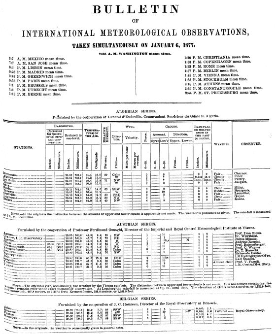 Image example
The publication of the Bulletin of International Simultaneous Observations, began July 1, 1875, with daily maps added in 1877. It was published for distribution among cooperative observers only, and continued daily through 1887. Observations were taken simultaneously at 7:35am (later changed to 7am) Washington mean time. The published daily bulletins cover the period from January 1, 1875, to June 30, 1884, while the corresponding daily charts extend from January 1, 1875, to December 31, 1887. On June 30, 1884, the publication of the daily bulletin was discontinued, but the daily map, the monthly summary, and the annual review were continued until their final cessation with December 31, 1887. Beginning July 1, 1884, the size of the published daily international chart was enlarged to four times its former size, and about July, 1885, the published and Annual Review, were enlarged to the same size, i. e., to the size of the manuscript compilation. The international data in these bulletins were carefully worked over into a homogeneous system by rules established before the publication of the first number for 1878, and expressed in both English and metric measures. The daily bulletins appeared regularly just about one year after the dates to which they pertained. The material was primarily intended as a basis for the study of the dynamics of the atmosphere, and not for climatological study. It is a mistake to treat them from the latter point of view; the charts present strictly simultaneous daily conditions over the whole Northern Hemisphere and are based on a larger number of simultaneous observations than those used for the Daily Weather Map of the Northern Hemisphere that began with January 1, 1914.
Dataset Citation
Cite this dataset when used as a source.
Dataset Identifiers
- NCEI DSI 3900_01
- gov.noaa.ncdc:C01087
ISO 19115-2 Metadata
gov.noaa.ncdc:C01087
| Download Data |
|
| Distribution Formats |
|
| Ordering Instructions | Contact NCEI for other distribution options and instructions. |
| Distributor |
NOAA National Centers for Environmental Information ncei.info@noaa.gov |
| Dataset Point of Contact | Jason Cooper NCDC Archivist DOC/NOAA/NESDIS/NCEI > National Centers for Environmental Information, NESDIS, NOAA, U.S. Department of Commerce +1 828-271-4800 ncei.orders@noaa.gov |
| Coverage Description | |
| Time Period | 1875 to 1887 |
| Spatial Bounding Box Coordinates |
West: -180
East: 180
South: -90
North: 90
|
| Spatial Coverage Map |
| Dataset Information |
|
| General Documentation |
|
| Publication Dates |
|
| Data Presentation Form | Digital image |
| Dataset Progress Status | Complete - production of the data has been completed |
| Data Update Frequency | Irregular |
| Purpose | In the late 1990s NCDC realized the need to host digital images of weather and climate records on the internet. As a result, EV2 was developed as a key system for providing access to the millions of original source data images in the NCDC archives. With its upload and index capability, EV2 also enables the continuation of NCDC's commitment to make more of its weather and climate data available online so that users across the world can view climate and weather records held in the NCDC archives. |
| Use Limitations |
|
| Publishers |
|
| Theme keywords |
Global Change Master Directory (GCMD) Science Keywords
|
| Data Center keywords |
Global Change Master Directory (GCMD) Data Center Keywords
|
| Platform keywords |
Global Change Master Directory (GCMD) Platform Keywords
|
| Instrument keywords |
Global Change Master Directory (GCMD) Instrument Keywords
|
| Place keywords |
Global Change Master Directory (GCMD) Location Keywords
|
| Stratum keywords |
Global Change Master Directory (GCMD) Location Keywords
|
| Use Constraints |
|
| Access Constraints |
|
| Fees |
|
| Lineage information for: repository | |
|---|---|
| Processing Steps |
|
Last Modified: 2023-06-23
For questions about the information on this page, please email: ncei.info@noaa.gov
For questions about the information on this page, please email: ncei.info@noaa.gov