Surface Observations from Punta Arenas, Chile
EV2 - Chile
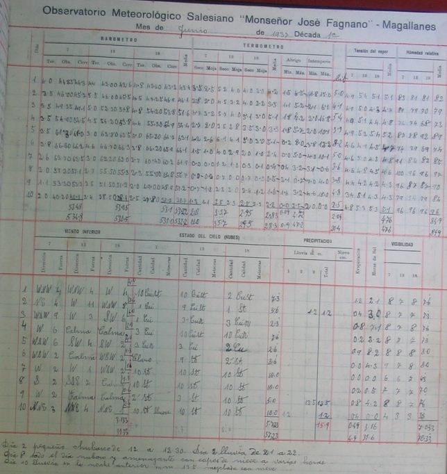 Image example
Surface Observations from Punta Arenas, in extreme southern Chile. WMO station ID 85934. Period of record 1896-1954. The original forms were scanned at the Museo Salesiano Maggiorino Borgatello, a private regional museum in Punta Arenas with funding provided by NOAA through the Environmental Services Data and Information Management (ESDIM) program carryover. However, since the Museum is a private organization not affiliated with the Chilean government or its agencies, its directors required an agreement with a non-profit organization in order for them to agree to allow NOAA to digitize their data and to make those digitized data free and unrestricted to the world community. This effort required some discretion as well as the intervention of a non-profit since the museum specifically expressed a desire not to work with the Chilean national meteorological service. CD-ROMs containing the images were sent to NCDC via the National Weather Service International Activities Office. A CDMP keying task was completed in 2006-07 to key and ingest data from 1896-1941 into digital data sets. This period had a consistent format, with one image for each ten-day period in each month
Dataset Citation
Cite this dataset when used as a source.
Dataset Identifiers
- NCEI DSI 3900_01
- gov.noaa.ncdc:C01088
ISO 19115-2 Metadata
gov.noaa.ncdc:C01088
| Download Data |
|
| Distribution Formats |
|
| Ordering Instructions | Contact NCEI for other distribution options and instructions. |
| Distributor |
NOAA National Centers for Environmental Information ncei.info@noaa.gov |
| Dataset Point of Contact | Jason Cooper NCDC Archivist DOC/NOAA/NESDIS/NCEI > National Centers for Environmental Information, NESDIS, NOAA, U.S. Department of Commerce +1 828-271-4800 ncei.orders@noaa.gov |
| Coverage Description | |
| Time Period | 1896 to 1954 |
| Spatial Bounding Box Coordinates |
West: -70.97
East: -70.96
South: -53.00
North: -52.99
|
| Spatial Coverage Map |
| Dataset Information |
|
| General Documentation |
|
| Publication Dates |
|
| Data Presentation Form | Digital image |
| Dataset Progress Status | Complete - production of the data has been completed |
| Data Update Frequency | Irregular |
| Purpose | In the late 1990s NCDC realized the need to host digital images of weather and climate records on the internet. As a result, EV2 was developed as a key system for providing access to the millions of original source data images in the NCDC archives. With its upload and index capability, EV2 also enables the continuation of NCDC's commitment to make more of its weather and climate data available online so that users across the world can view climate and weather records held in the NCDC archives. |
| Use Limitations |
|
| Publishers |
|
| Theme keywords |
Global Change Master Directory (GCMD) Science Keywords
|
| Data Center keywords |
Global Change Master Directory (GCMD) Data Center Keywords
|
| Platform keywords |
Global Change Master Directory (GCMD) Platform Keywords
|
| Instrument keywords |
Global Change Master Directory (GCMD) Instrument Keywords
|
| Place keywords |
Global Change Master Directory (GCMD) Location Keywords
|
| Stratum keywords |
Global Change Master Directory (GCMD) Location Keywords
|
| Use Constraints |
|
| Access Constraints |
|
| Fees |
|
| Lineage information for: repository | |
|---|---|
| Processing Steps |
|
Last Modified: 2023-06-23
For questions about the information on this page, please email: ncei.info@noaa.gov
For questions about the information on this page, please email: ncei.info@noaa.gov