Cooperative Weather Observations
EV2 - Cooperative Observations
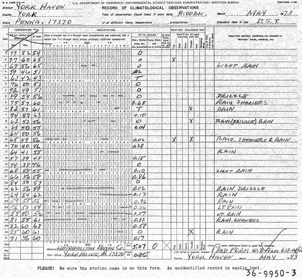 Image example
Monthly logs include a daily account of temperature extremes and precipitation, along with snow data at some locations. U.S. Cooperative Observer Program (COOP) Network stations scattered across the continental U.S., a few from Caribbean and Pacific Island stations. Cooperative stations are assigned a six-digit COOPID in which the first two correspond to the state, and the last four are assigned roughly in alphabetical order by station name. For a complete list of station IDs, see the cooperative station list at http://www.ncdc.noaa.gov/homr/reports/mshr . Stations that were not a part of the network at the time the reports were submitted are assigned ID 777777
Dataset Citation
Cite this dataset when used as a source.
Dataset Identifiers
- NCEI DSI 3900_01
- gov.noaa.ncdc:C01097
ISO 19115-2 Metadata
gov.noaa.ncdc:C01097
| Download Data |
|
| Distribution Formats |
|
| Ordering Instructions | Contact NCEI for other distribution options and instructions. |
| Distributor |
NOAA National Centers for Environmental Information ncei.info@noaa.gov |
| Dataset Point of Contact | Jason Cooper NCDC Archivist DOC/NOAA/NESDIS/NCEI > National Centers for Environmental Information, NESDIS, NOAA, U.S. Department of Commerce +1 828-271-4800 ncei.orders@noaa.gov |
| Coverage Description | |
| Time Period | 1890 to Present |
| Spatial Bounding Box Coordinates |
West: -180
East: 180
South: -90
North: 90
|
| Spatial Coverage Map |
| Dataset Information |
|
| General Documentation |
|
| Publication Dates |
|
| Data Presentation Form | Digital image |
| Dataset Progress Status | Ongoing - data is continually being updated |
| Data Update Frequency | Irregular |
| Purpose | In the late 1990s NCDC realized the need to host digital images of weather and climate records on the internet. As a result, EV2 was developed as a key system for providing access to the millions of original source data images in the NCDC archives. With its upload and index capability, EV2 also enables the continuation of NCDC's commitment to make more of its weather and climate data available online so that users across the world can view climate and weather records held in the NCDC archives. |
| Use Limitations |
|
| Publishers |
|
| Theme keywords |
Global Change Master Directory (GCMD) Science Keywords
|
| Data Center keywords |
Global Change Master Directory (GCMD) Data Center Keywords
|
| Platform keywords |
Global Change Master Directory (GCMD) Platform Keywords
|
| Instrument keywords |
Global Change Master Directory (GCMD) Instrument Keywords
|
| Place keywords |
Global Change Master Directory (GCMD) Location Keywords
|
| Stratum keywords |
Global Change Master Directory (GCMD) Location Keywords
|
| Use Constraints |
|
| Access Constraints |
|
| Fees |
|
| Lineage information for: repository | |
|---|---|
| Processing Steps |
|
Last Modified: 2023-06-23
For questions about the information on this page, please email: ncei.info@noaa.gov
For questions about the information on this page, please email: ncei.info@noaa.gov