US Naval Base Hourly Observations
EV2 - Surface Weather Observations Navy
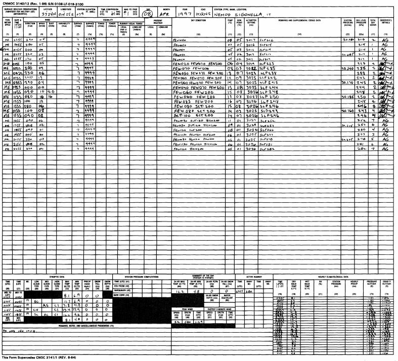 Image example
US Navy hourly observations taken at Naval bases worldwide. Observations begin 1995.
Cite this dataset when used as a source.
- NCEI DSI 3900_01
- gov.noaa.ncdc:C01108
| Download Data |
|
| Distribution Formats |
- XML
- PDF
- File Specification:
- File Compression:
|
| Ordering Instructions |
Contact NCEI for other distribution options and instructions. |
| Distributor |
NOAA National Centers for Environmental Information
ncei.info@noaa.gov
|
| Dataset Point of Contact |
Jason Cooper
NCDC Archivist
DOC/NOAA/NESDIS/NCEI > National Centers for Environmental Information, NESDIS, NOAA, U.S. Department of Commerce
+1 828-271-4800
ncei.orders@noaa.gov
|
| Coverage Description |
|
| Time Period |
1995 to Present |
| Spatial Bounding Box Coordinates |
West: -180
East: 180
South: -90
North: 90
|
| Spatial Coverage Map |
|
| Dataset Information |
-
CDMP Web site
Information about the Climate Database Modernization Program (CDMP) and the current Image Access Repository.
|
| General Documentation |
|
| Publication Dates |
- publication: 2011-03-15
- revision: 2013-05-02
|
| Data Presentation Form |
Digital image
|
| Dataset Progress Status |
Ongoing - data is continually being updated |
| Data Update Frequency |
Irregular |
| Purpose |
In the late 1990s NCDC realized the need to host digital images of weather and climate records on the internet. As a result, EV2 was developed as a key system for providing access to the millions of original source data images in the NCDC archives. With its upload and index capability, EV2 also enables the continuation of NCDC's commitment to make more of its weather and climate data available online so that users across the world can view climate and weather records held in the NCDC archives. |
| Use Limitations |
- Controlled user access to the EV2 system
|
| Publishers |
- DOC/NOAA/NESDIS/NCEI > National Centers for Environmental Information, NESDIS, NOAA, U.S. Department of Commerce
- DOC/NOAA/NESDIS/NCDC > National Climatic Data Center, NESDIS, NOAA, U.S. Department of Commerce
|
| Theme keywords |
Global Change Master Directory (GCMD) Science Keywords
- Earth Science > Atmosphere > Atmospheric Pressure > Anticyclones/Cyclones
- Earth Science > Atmosphere > Atmospheric Pressure > Pressure Anomalies
- Earth Science > Atmosphere > Precipitation > Solid Precipitation > Hail
- Earth Science > Atmosphere > Precipitation > Precipitation Amount
- Earth Science > Atmosphere > Precipitation > Precipitation Anomalies
- Earth Science > Atmosphere > Precipitation > Precipitation Rate
- Earth Science > Atmosphere > Precipitation > Liquid Precipitation > Rain
- Earth Science > Atmosphere > Precipitation > Solid Precipitation > Ice Pellets > Sleet
- Earth Science > Atmosphere > Precipitation > Solid Precipitation > Snow
- Earth Science > Atmosphere > Atmospheric Temperature > Surface Temperature > Air Temperature
- Earth Science > Atmosphere > Atmospheric Temperature > Surface Temperature > Maximum/Minimum Temperature
- Earth Science > Atmosphere > Atmospheric Temperature > Surface Temperature
- Earth Science > Atmosphere > Atmospheric Temperature > Temperature Anomalies
- Earth Science > Atmosphere > Atmospheric Winds > Surface Winds
Global Climate Observing System (GCOS) Essential Climate Variables (ECVs)
- Atmospheric - Surface - Air Temperature
- Atmospheric - Surface - Precipitation
- Atmospheric - Surface - Pressure
- Atmospheric - Surface - Wind Speed And Direction
- Atmospheric - Upper-air - Cloud Properties
|
| Data Center keywords |
Global Change Master Directory (GCMD) Data Center Keywords
- DOC/NOAA/NESDIS/NCDC > National Climatic Data Center, NESDIS, NOAA, U.S. Department of Commerce
- DOC/NOAA/NESDIS/NCEI > National Centers for Environmental Information, NESDIS, NOAA, U.S. Department of Commerce
|
| Platform keywords |
Global Change Master Directory (GCMD) Platform Keywords
|
| Instrument keywords |
Global Change Master Directory (GCMD) Instrument Keywords
- Thermometers
- Anemometers
- Rain Gauges
- Barometers
- Visual Observations
|
| Place keywords |
Global Change Master Directory (GCMD) Location Keywords- Geographic Region > Global
|
| Stratum keywords |
Global Change Master Directory (GCMD) Location Keywords- Vertical Location > Land Surface
|
| Use Constraints |
- Use liability: NOAA and NCEI cannot provide any warranty as to the accuracy, reliability, or completeness of furnished data. Users assume responsibility to determine the usability of these data. The user is responsible for the results of any application of this data for other than its intended purpose.
|
| Access Constraints |
- Distribution liability: NOAA and NCEI make no warranty, expressed or implied, regarding these data, nor does the fact of distribution constitute such a warranty. NOAA and NCEI cannot assume liability for any damages caused by any errors or omissions in these data. If appropriate, NCEI can only certify that the data it distributes are an authentic copy of the records that were accepted for inclusion in the NCEI archives.
|
| Fees |
- In most cases, electronic downloads of the data are free. However, fees may apply for custom orders, data certifications, copies of analog materials, and data distribution on physical media.
|
| Lineage information for: repository |
|---|
| Processing Steps |
- 2015-04-22T00:00:00 - NOAA created the National Centers for Environmental Information (NCEI) by merging NOAA's National Climatic Data Center (NCDC), National Geophysical Data Center (NGDC), and National Oceanographic Data Center (NODC), including the National Coastal Data Development Center (NCDDC), per the Consolidated and Further Continuing Appropriations Act, 2015, Public Law 113-235. NCEI launched publicly on April 22, 2015.
|
Last Modified: 2023-06-23
For questions about the information on this page, please email:
ncei.info@noaa.gov