NOAA JPSS Visible Infrared Imaging Radiometer Suite (VIIRS) Snow Cover/Depth (SCD) Snow Fraction Environmental Data Record (EDR) from IDPS
- referenceSystemInfo
- identificationInfo
- contentInfo
- distributionInfo
- dataQualityInfo
- dataQualityInfo
- metadataMaintenance
(MI_Metadata)
fileIdentifier: gov.noaa.ncdc:C01419
language: eng; USA
characterSet: (MD_CharacterSetCode) utf8
hierarchyLevel: (MD_ScopeCode) dataset
contact: (CI_ResponsibleParty)
organisationName: NOAA National Centers for Environmental Information
contactInfo: (CI_Contact)
address: (CI_Address)
electronicMailAddress: ncei.info@noaa.gov
onlineResource: (CI_OnlineResource)
linkage: https://www.ncei.noaa.gov/contact
name: NCEI Contact Information
description: Information for contacts at NCEI.
function: (CI_OnLineFunctionCode) information
role: (CI_RoleCode) pointOfContact
dateStamp: 2023-06-23
metadataStandardName: ISO 19115-2 Geographic Information - Metadata - Part 2: Extensions for Imagery and Gridded Data
metadataStandardVersion: ISO 19115-2:2009(E)
return to top
referenceSystemInfo: (MD_ReferenceSystem)
referenceSystemIdentifier: (RS_Identifier)
authority: (CI_Citation)
title: EPSG Geodetic Parameter Dataset Registry
date: (CI_Date)
date: 2008-11-12
dateType: (CI_DateTypeCode) publication
citedResponsibleParty: (CI_ResponsibleParty)
organisationName: International Association of Oil and Gas Producers (OGP) Geomatics Committee
contactInfo: (CI_Contact)
onlineResource: (CI_OnlineResource)
linkage: http://www.epsg-registry.org/
applicationProfile: Data Search Application
name: EPSG Geodetic Parameter Dataset Registry Application
description: Interface to the EPSG Geodetic Parameter Dataset Registry
function: (CI_OnLineFunctionCode) search
role: (CI_RoleCode) custodian
citedResponsibleParty: (CI_ResponsibleParty)
organisationName: International Association of Oil and Gas Producers (OGP) Geomatics Committee
contactInfo: (CI_Contact)
onlineResource: (CI_OnlineResource)
linkage: http://www.epsg-registry.org/export.htm?gml=urn:ogc:def:crs:EPSG::4326
applicationProfile: Download
name: Coordinate Reference System data in GML
description: Coordinate Reference System data in GML
function: (CI_OnLineFunctionCode) download
role: (CI_RoleCode) custodian
code: urn:ogc:def:crs:EPSG::4326
version: (unknown)
return to top
identificationInfo: (MD_DataIdentification)
citation: (CI_Citation)
title: NOAA JPSS Visible Infrared Imaging Radiometer Suite (VIIRS) Snow Cover/Depth (SCD) Snow Fraction Environmental Data Record (EDR) from IDPS
alternateTitle: VIIRS-SCD-BINARY-SNOW-FRAC-EDR
date: (CI_Date)
date: 2012-10-15
dateType: (CI_DateTypeCode) publication
edition: Validated
identifier: (MD_Identifier)
code: gov.noaa.ncdc:C01419
identifier: (MD_Identifier)
code: gov.noaa.class:VIIRS_EDR
identifier: (MD_Identifier)
code: JPSS Product ID:VSCDO
citedResponsibleParty: (CI_ResponsibleParty)
organisationName: NOAA National Centers for Environmental Information
role: (CI_RoleCode) publisher
citedResponsibleParty: (CI_ResponsibleParty)
individualName: Key, Jeffery
organisationName: DOC/NOAA/NESDIS/STAR > Center for Satellite Applications and Research, NESDIS, NOAA, U.S. Department of Commerce
role: (CI_RoleCode) principalInvestigator
citedResponsibleParty: (CI_ResponsibleParty)
individualName: Key, Jeffery
organisationName: DOC/NOAA/NESDIS/STAR > Center for Satellite Applications and Research, NESDIS, NOAA, U.S. Department of Commerce
role: (CI_RoleCode) author
citedResponsibleParty: (CI_ResponsibleParty)
individualName: Qiu, Shuang
organisationName: DOC/NOAA/NESDIS/OSPO > Office of Satellite and Product Operations, Center for Satellite Applications and Research, NESDIS, NOAA, U.S. Department of Commerce
role: (CI_RoleCode) principalInvestigator
citedResponsibleParty: (CI_ResponsibleParty)
individualName: Qiu, Shuang
organisationName: DOC/NOAA/NESDIS/OSPO > Office of Satellite and Product Operations, Center for Satellite Applications and Research, NESDIS, NOAA, U.S. Department of Commerce
role: (CI_RoleCode) author
citedResponsibleParty: (CI_ResponsibleParty)
organisationName: NOAA JPSS Program Office
role: (CI_RoleCode) originator
citedResponsibleParty: (CI_ResponsibleParty)
organisationName: NOAA JPSS Program Office
role: (CI_RoleCode) author
presentationForm: (CI_PresentationFormCode) imageDigital
abstract: This dataset contains a high quality operational Environmental Data Record (EDR) of Snow Cover/Depth Fraction (SCF) from the Visible Infrared Imaging Radiometer Suite (VIIRS) instrument onboard the Suomi-NPP satellite and is produced by the NOAA Environmental Satellite, Data, and Information Service (NESDIS). The VIIRS SCF EDR is based on a 2x2 aggregation of the VIIRS imagery resolution binary snow map at a spatial resolution of 750 meters at nadir during daytime over cloud-free land masses. The algorithm utilizes VIIRS spectral bands I1 (640 nm), I2 (865 nm), I3 (1.61 micron), I5 (11.5 micron), M15 (11 micron), M16 (12 micron), and several VIIRS Intermediate Products (IP) including Cloud Mask (VCM), Aerosol Optical Thickness (AOT), and Cloud Optical Thickness (COT). By default, IDPS VIIRS SCF obtained from the Comprehensive Large-Array Stewardship System (CLASS) are distributed in four aggregated 86-second granules in Hierarchical Data Format v.5 (HDF5) with metadata attributes included.
purpose: This VIIRS Snow Cover/Depth Snow Fraction EDR can be used for environmental and climate modeling, weather forecasting, and snow pack analysis.
status: (MD_ProgressCode) onGoing
pointOfContact: (CI_ResponsibleParty)
individualName: Customer Engagement Branch
organisationName: DOC/NOAA/NESDIS/NCEI > National Centers for Environmental Information, NESDIS, NOAA, U.S. Department of Commerce
contactInfo: (CI_Contact)
address: (CI_Address)
electronicMailAddress: ncei.sat.info@noaa.gov
role: (CI_RoleCode) pointOfContact
resourceMaintenance: (MD_MaintenanceInformation)
maintenanceAndUpdateFrequency: (MD_MaintenanceFrequencyCode) continual
graphicOverview: (MD_BrowseGraphic)
fileName: https://www.ncei.noaa.gov/pub/data/metadata/images/C01419_SNPP_VIIRS_SCF_EDR.png
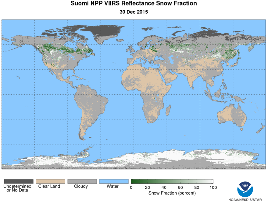
fileDescription: Example of the VIIRS Snow Cover/Depth Snow Fraction EDR depicting global snow cover fraction on December 30, 2015. Image courtesy of the JPSS LTM system.
fileType: PNG
descriptiveKeywords: (MD_Keywords)
keyword: Earth Science > Cryosphere > Snow/Ice > Snow Cover
type: (MD_KeywordTypeCode) theme
thesaurusName: (CI_Citation)
title: Global Change Master Directory (GCMD) Science Keywords
date: (CI_Date)
date: 2018
dateType: (CI_DateTypeCode) revision
edition: Version 8.6
citedResponsibleParty: (CI_ResponsibleParty)
organisationName: Global Change Data Center, Science and Exploration Directorate, Goddard Space Flight Center (GSFC) National Aeronautics and Space Administration (NASA)
contactInfo: (CI_Contact)
onlineResource: (CI_OnlineResource)
linkage: https://earthdata.nasa.gov/about/gcmd/global-change-master-directory-gcmd-keywords
protocol: HTTPS
applicationProfile: Web Browser
name: Global Change Master Directory (GCMD) Keywords
description: The information provided on this page seeks to define how the GCMD Keywords are structured, used and accessed. It also provides information on how users can participate in the further development of the keywords.
function: (CI_OnLineFunctionCode) information
role: (CI_RoleCode) publisher
descriptiveKeywords: (MD_Keywords)
keyword: Terrestrial - Snow Cover
type: (MD_KeywordTypeCode) theme
thesaurusName: (CI_Citation)
title: Global Climate Observing System (GCOS) Essential Climate Variables (ECVs)
date: (CI_Date)
date: 2017
dateType: (CI_DateTypeCode) publication
edition: Release 2017
citedResponsibleParty: (CI_ResponsibleParty)
organisationName: World Meteorological Organization, United Nations
contactInfo: (CI_Contact)
onlineResource: (CI_OnlineResource)
linkage: https://public.wmo.int/en/programmes/global-climate-observing-system/essential-climate-variables
protocol: HTTP
applicationProfile: Information
name: GCOS Essential Climate Variables
description: Overview of the GCOS Essential Climate Variables.
function: (CI_OnLineFunctionCode) information
role: (CI_RoleCode) custodian
descriptiveKeywords: (MD_Keywords)
keyword: Geographic Region > Global Land
type: (MD_KeywordTypeCode) place
thesaurusName: (CI_Citation)
title: Global Change Master Directory (GCMD) Location Keywords
date: (CI_Date)
date: 2018
dateType: (CI_DateTypeCode) revision
edition: Version 8.6
citedResponsibleParty: (CI_ResponsibleParty)
organisationName: Global Change Data Center, Science and Exploration Directorate, Goddard Space Flight Center (GSFC) National Aeronautics and Space Administration (NASA)
contactInfo: (CI_Contact)
onlineResource: (CI_OnlineResource)
linkage: https://earthdata.nasa.gov/about/gcmd/global-change-master-directory-gcmd-keywords
protocol: HTTPS
applicationProfile: Web Browser
name: Global Change Master Directory (GCMD) Keywords
description: The information provided on this page seeks to define how the GCMD Keywords are structured, used and accessed. It also provides information on how users can participate in the further development of the keywords.
function: (CI_OnLineFunctionCode) information
role: (CI_RoleCode) publisher
descriptiveKeywords: (MD_Keywords)
keyword: Vertical Location > Land Surface
type: (MD_KeywordTypeCode) stratum
thesaurusName: (CI_Citation)
title: Global Change Master Directory (GCMD) Location Keywords
date: (CI_Date)
date: 2018
dateType: (CI_DateTypeCode) revision
edition: Version 8.6
citedResponsibleParty: (CI_ResponsibleParty)
organisationName: Global Change Data Center, Science and Exploration Directorate, Goddard Space Flight Center (GSFC) National Aeronautics and Space Administration (NASA)
contactInfo: (CI_Contact)
onlineResource: (CI_OnlineResource)
linkage: https://earthdata.nasa.gov/about/gcmd/global-change-master-directory-gcmd-keywords
protocol: HTTPS
applicationProfile: Web Browser
name: Global Change Master Directory (GCMD) Keywords
description: The information provided on this page seeks to define how the GCMD Keywords are structured, used and accessed. It also provides information on how users can participate in the further development of the keywords.
function: (CI_OnLineFunctionCode) information
role: (CI_RoleCode) publisher
descriptiveKeywords: (MD_Keywords)
keyword: JPSS > Joint Polar Satellite System
type: (MD_KeywordTypeCode) project
thesaurusName: (CI_Citation)
title: Global Change Master Directory (GCMD) Project Keywords
date: (CI_Date)
date: 2018
dateType: (CI_DateTypeCode) revision
edition: Version 8.6
citedResponsibleParty: (CI_ResponsibleParty)
organisationName: Global Change Data Center, Science and Exploration Directorate, Goddard Space Flight Center (GSFC) National Aeronautics and Space Administration (NASA)
contactInfo: (CI_Contact)
onlineResource: (CI_OnlineResource)
linkage: https://earthdata.nasa.gov/about/gcmd/global-change-master-directory-gcmd-keywords
protocol: HTTPS
applicationProfile: Web Browser
name: Global Change Master Directory (GCMD) Keywords
description: The information provided on this page seeks to define how the GCMD Keywords are structured, used and accessed. It also provides information on how users can participate in the further development of the keywords.
function: (CI_OnLineFunctionCode) information
role: (CI_RoleCode) publisher
descriptiveKeywords: (MD_Keywords)
keyword: VIIRS > Visible-Infrared Imager-Radiometer Suite
type: (MD_KeywordTypeCode) instrument
thesaurusName: (CI_Citation)
title: Global Change Master Directory (GCMD) Instrument Keywords
date: (CI_Date)
date: 2018
dateType: (CI_DateTypeCode) revision
edition: Version 8.6
citedResponsibleParty: (CI_ResponsibleParty)
organisationName: Global Change Data Center, Science and Exploration Directorate, Goddard Space Flight Center (GSFC) National Aeronautics and Space Administration (NASA)
contactInfo: (CI_Contact)
onlineResource: (CI_OnlineResource)
linkage: https://earthdata.nasa.gov/about/gcmd/global-change-master-directory-gcmd-keywords
protocol: HTTPS
applicationProfile: Web Browser
name: Global Change Master Directory (GCMD) Keywords
description: The information provided on this page seeks to define how the GCMD Keywords are structured, used and accessed. It also provides information on how users can participate in the further development of the keywords.
function: (CI_OnLineFunctionCode) information
role: (CI_RoleCode) publisher
descriptiveKeywords: (MD_Keywords)
keyword: SUOMI-NPP > Suomi National Polar-orbiting Partnership
type: (MD_KeywordTypeCode) platform
thesaurusName: (CI_Citation)
title: Global Change Master Directory (GCMD) Platform Keywords
date: (CI_Date)
date: 2018
dateType: (CI_DateTypeCode) revision
edition: Version 8.6
citedResponsibleParty: (CI_ResponsibleParty)
organisationName: Global Change Data Center, Science and Exploration Directorate, Goddard Space Flight Center (GSFC) National Aeronautics and Space Administration (NASA)
contactInfo: (CI_Contact)
onlineResource: (CI_OnlineResource)
linkage: https://earthdata.nasa.gov/about/gcmd/global-change-master-directory-gcmd-keywords
protocol: HTTPS
applicationProfile: Web Browser
name: Global Change Master Directory (GCMD) Keywords
description: The information provided on this page seeks to define how the GCMD Keywords are structured, used and accessed. It also provides information on how users can participate in the further development of the keywords.
function: (CI_OnLineFunctionCode) information
role: (CI_RoleCode) publisher
descriptiveKeywords: (MD_Keywords)
keyword: 250 meters - < 500 meters
type: (MD_KeywordTypeCode) dataResolution
thesaurusName: (CI_Citation)
title: Global Change Master Directory (GCMD) Horizontal Data Resolution Keywords
date: (CI_Date)
date: 2018
dateType: (CI_DateTypeCode) revision
edition: Version 8.6
citedResponsibleParty: (CI_ResponsibleParty)
organisationName: Global Change Data Center, Science and Exploration Directorate, Goddard Space Flight Center (GSFC) National Aeronautics and Space Administration (NASA)
contactInfo: (CI_Contact)
onlineResource: (CI_OnlineResource)
linkage: https://earthdata.nasa.gov/about/gcmd/global-change-master-directory-gcmd-keywords
protocol: HTTPS
applicationProfile: Web Browser
name: Global Change Master Directory (GCMD) Keywords
description: The information provided on this page seeks to define how the GCMD Keywords are structured, used and accessed. It also provides information on how users can participate in the further development of the keywords.
function: (CI_OnLineFunctionCode) information
role: (CI_RoleCode) publisher
descriptiveKeywords: (MD_Keywords)
keyword: Daily - < Weekly
type: (MD_KeywordTypeCode) dataResolution
thesaurusName: (CI_Citation)
title: Global Change Master Directory (GCMD) Temporal Data Resolution Keywords
date: (CI_Date)
date: 2018
dateType: (CI_DateTypeCode) revision
edition: Version 8.6
citedResponsibleParty: (CI_ResponsibleParty)
organisationName: Global Change Data Center, Science and Exploration Directorate, Goddard Space Flight Center (GSFC) National Aeronautics and Space Administration (NASA)
contactInfo: (CI_Contact)
onlineResource: (CI_OnlineResource)
linkage: https://earthdata.nasa.gov/about/gcmd/global-change-master-directory-gcmd-keywords
protocol: HTTPS
applicationProfile: Web Browser
name: Global Change Master Directory (GCMD) Keywords
description: The information provided on this page seeks to define how the GCMD Keywords are structured, used and accessed. It also provides information on how users can participate in the further development of the keywords.
function: (CI_OnLineFunctionCode) information
role: (CI_RoleCode) publisher
descriptiveKeywords: (MD_Keywords)
keyword: DOC/NOAA/NESDIS/NCDC > National Climatic Data Center, NESDIS, NOAA, U.S. Department of Commerce
keyword: DOC/NOAA/NESDIS/NCEI > National Centers for Environmental Information, NESDIS, NOAA, U.S. Department of Commerce
keyword: DOC/NOAA/NESDIS/STAR > Center for Satellite Applications and Research, NESDIS, NOAA, U.S. Department of Commerce
keyword: DOC/NOAA/NESDIS/OSPO > Office of Satellite and Product Operations, NESDIS, NOAA, U.S. Department of Commerce
type: (MD_KeywordTypeCode) dataCentre
thesaurusName: (CI_Citation)
title: Global Change Master Directory (GCMD) Data Center Keywords
date: (CI_Date)
date: 2018
dateType: (CI_DateTypeCode) revision
edition: Version 8.6
citedResponsibleParty: (CI_ResponsibleParty)
organisationName: Global Change Data Center, Science and Exploration Directorate, Goddard Space Flight Center (GSFC) National Aeronautics and Space Administration (NASA)
contactInfo: (CI_Contact)
onlineResource: (CI_OnlineResource)
linkage: https://earthdata.nasa.gov/about/gcmd/global-change-master-directory-gcmd-keywords
protocol: HTTPS
applicationProfile: Web Browser
name: Global Change Master Directory (GCMD) Keywords
description: The information provided on this page seeks to define how the GCMD Keywords are structured, used and accessed. It also provides information on how users can participate in the further development of the keywords.
function: (CI_OnLineFunctionCode) information
role: (CI_RoleCode) publisher
descriptiveKeywords: (MD_Keywords)
keyword: gov.noaa.class:VIIRS_EDR
type: (MD_KeywordTypeCode) other
resourceConstraints: (MD_Constraints)
useLimitation: For a complete description of use limitations for this EDR, see the Algorithm Theoretical Basis Document (ATBD).
resourceConstraints: (MD_LegalConstraints)
useConstraints: (MD_RestrictionCode) otherRestrictions
otherConstraints: Cite as: Key, Jeffrey, Qiu, Shuang, and NOAA JPSS Program Office (2012): NOAA JPSS Visible Infrared Imaging Radiometer Suite (VIIRS) Snow Cover/Depth Snow Fraction Environmental Data Record (EDR) from IDPS. [indicate subset used]. NOAA National Centers for Environmental Information. [access date].
resourceConstraints: (MD_LegalConstraints)
accessConstraints: (MD_RestrictionCode) otherRestrictions
otherConstraints: Distribution liability: NOAA and NCEI make no warranty, expressed or implied, regarding these data, nor does the fact of distribution constitute such a warranty. NOAA and NCEI cannot assume liability for any damages caused by any errors or omissions in these data. If appropriate, NCEI can only certify that the data it distributes are an authentic copy of the records that were accepted for inclusion in the NCEI archives.
resourceConstraints: (MD_LegalConstraints)
useConstraints: (MD_RestrictionCode) otherRestrictions
otherConstraints: Use liability: NOAA and NCEI cannot provide any warranty as to the accuracy, reliability, or completeness of furnished data. Users assume responsibility to determine the usability of these data. The user is responsible for the results of any application of this data for other than its intended purpose.
aggregationInfo: (MD_AggregateInformation)
aggregateDataSetName: (CI_Citation)
title: Snow and ice products from Suomi NPP VIIRS
date: (CI_Date)
date: 2013-12-03
dateType: (CI_DateTypeCode) publication
identifier: (MD_Identifier)
code: doi:10.1002/2013JD020459
citedResponsibleParty: (CI_ResponsibleParty)
organisationName: Wiley
role: (CI_RoleCode) publisher
citedResponsibleParty: (CI_ResponsibleParty)
organisationName: (missing)
contactInfo: (CI_Contact)
onlineResource: (CI_OnlineResource)
linkage: https://doi.org/10.1002/2013JD020459
protocol: HTTPS
applicationProfile: Web Browser
name: Journal article published December 2013 by Wiley (Journal of Geophysical Research Atmosphere)
description: Key, J., Mahoney, R., et al., (2013), Snow and ice products from Suomi NPP VIIRS, J. of Geo. Res. Atmo., 118(23), 12816—12830, doi:10.1002/2013JD020459.
function: (CI_OnLineFunctionCode) information
role: (missing)
associationType: (DS_AssociationTypeCode) crossReference
initiativeType: (DS_InitiativeTypeCode) sciencePaper
spatialRepresentationType: (MD_SpatialRepresentationTypeCode) grid
spatialResolution: (MD_Resolution)
distance:
Distance: 375
language: eng; USA
topicCategory: (MD_TopicCategoryCode) climatologyMeteorologyAtmosphere
extent: (EX_Extent)
geographicElement: (EX_GeographicBoundingBox)
extentTypeCode: 1
westBoundLongitude: -180.0
eastBoundLongitude: 180.0
southBoundLatitude: -90.0
northBoundLatitude: 90.0
temporalElement: (EX_TemporalExtent)
extent:
TimePeriod:
description: ground condition
beginPosition: 2012-10-15
endPosition:
timeInterval: 24
return to top
contentInfo: (MI_CoverageDescription)
attributeDescription:
RecordType: VSCDO_npp_dYYYYMMDD_tHHMMSSS_eHHMMSSS_b####_cYYYYMMDDHHMMSSSSSSSS_XXXX_XXX.h5
contentType: (MD_CoverageContentTypeCode) physicalMeasurement
dimension: (MD_Band)
sequenceIdentifier:
MemberName:
aName: Height
attributeType:
TypeName:
aName: float
descriptor: (missing)
dimension: (MD_Band)
sequenceIdentifier:
MemberName:
aName: Latitude
attributeType:
TypeName:
aName: float
descriptor: (missing)
dimension: (MD_Band)
sequenceIdentifier:
MemberName:
aName: Longitude
attributeType:
TypeName:
aName: float
descriptor: (missing)
dimension: (MD_Band)
sequenceIdentifier:
MemberName:
aName: MidTime
attributeType:
TypeName:
aName: long
descriptor: (missing)
dimension: (MD_Band)
sequenceIdentifier:
MemberName:
aName: ModeGran
attributeType:
TypeName:
aName: byte
descriptor: (missing)
dimension: (MD_Band)
sequenceIdentifier:
MemberName:
aName: ModeScan
attributeType:
TypeName:
aName: byte
descriptor: (missing)
dimension: (MD_Band)
sequenceIdentifier:
MemberName:
aName: NumberOfScans
attributeType:
TypeName:
aName: int
descriptor: (missing)
dimension: (MD_Band)
sequenceIdentifier:
MemberName:
aName: PadByte1
attributeType:
TypeName:
aName: byte
descriptor: (missing)
dimension: (MD_Band)
sequenceIdentifier:
MemberName:
aName: QF1_SCAN_VIIRSSDRGEO
attributeType:
TypeName:
aName: byte
descriptor: (missing)
dimension: (MD_Band)
sequenceIdentifier:
MemberName:
aName: QF2_SCAN_VIIRSSDRGEO
attributeType:
TypeName:
aName: byte
descriptor: (missing)
dimension: (MD_Band)
sequenceIdentifier:
MemberName:
aName: QF2_VIIRSSDRGEO
attributeType:
TypeName:
aName: byte
descriptor: (missing)
dimension: (MD_Band)
sequenceIdentifier:
MemberName:
aName: SCAttitude
attributeType:
TypeName:
aName: float
descriptor: (missing)
dimension: (MD_Band)
sequenceIdentifier:
MemberName:
aName: SCPosition
attributeType:
TypeName:
aName: float
descriptor: (missing)
dimension: (MD_Band)
sequenceIdentifier:
MemberName:
aName: SCSolarAzimuthAngle
attributeType:
TypeName:
aName: float
descriptor: (missing)
dimension: (MD_Band)
sequenceIdentifier:
MemberName:
aName: SCSolarZenithAngle
attributeType:
TypeName:
aName: float
descriptor: (missing)
dimension: (MD_Band)
sequenceIdentifier:
MemberName:
aName: SCVelocity
attributeType:
TypeName:
aName: float
descriptor: (missing)
dimension: (MD_Band)
sequenceIdentifier:
MemberName:
aName: SatelliteAzimuthAngle
attributeType:
TypeName:
aName: float
descriptor: (missing)
dimension: (MD_Band)
sequenceIdentifier:
MemberName:
aName: SatelliteRange
attributeType:
TypeName:
aName: float
descriptor: (missing)
dimension: (MD_Band)
sequenceIdentifier:
MemberName:
aName: SatelliteZenithAngle
attributeType:
TypeName:
aName: float
descriptor: (missing)
dimension: (MD_Band)
sequenceIdentifier:
MemberName:
aName: SolarAzimuthAngle
attributeType:
TypeName:
aName: float
descriptor: (missing)
dimension: (MD_Band)
sequenceIdentifier:
MemberName:
aName: SolarZenithAngle
attributeType:
TypeName:
aName: float
descriptor: (missing)
dimension: (MD_Band)
sequenceIdentifier:
MemberName:
aName: StartTime
attributeType:
TypeName:
aName: long
descriptor: (missing)
dimension: (MD_Band)
sequenceIdentifier:
MemberName:
aName: NumberOfAggregatedPixels
attributeType:
TypeName:
aName: byte
descriptor: (missing)
dimension: (MD_Band)
sequenceIdentifier:
MemberName:
aName: QF1_VIIRSSCDBINARYSNOWFRACEDR
attributeType:
TypeName:
aName: byte
descriptor: (missing)
dimension: (MD_Band)
sequenceIdentifier:
MemberName:
aName: QF2_VIIRSSCDBINARYSNOWFRACEDR
attributeType:
TypeName:
aName: byte
descriptor: (missing)
dimension: (MD_Band)
sequenceIdentifier:
MemberName:
aName: QF3_VIIRSSCDBINARYSNOWFRACEDR
attributeType:
TypeName:
aName: byte
descriptor: (missing)
dimension: (MD_Band)
sequenceIdentifier:
MemberName:
aName: SnowCoverFraction
attributeType:
TypeName:
aName: short
descriptor: (missing)
dimension: (MD_Band)
sequenceIdentifier:
MemberName:
aName: SnowCoverFractionFactors
attributeType:
TypeName:
aName: float
descriptor: (missing)
dimension: (MD_Band)
sequenceIdentifier:
MemberName:
aName: VIIRS-MOD-GEO-TC_Aggr
attributeType:
TypeName:
aName: String
descriptor: (missing)
dimension: (MD_Band)
sequenceIdentifier:
MemberName:
aName: VIIRS-MOD-GEO-TC_Gran_0
attributeType:
TypeName:
aName: long
descriptor: (missing)
dimension: (MD_Band)
sequenceIdentifier:
MemberName:
aName: VIIRS-MOD-GEO-TC_Gran_1
attributeType:
TypeName:
aName: long
descriptor: (missing)
dimension: (MD_Band)
sequenceIdentifier:
MemberName:
aName: VIIRS-MOD-GEO-TC_Gran_2
attributeType:
TypeName:
aName: long
descriptor: (missing)
dimension: (MD_Band)
sequenceIdentifier:
MemberName:
aName: VIIRS-MOD-GEO-TC_Gran_3
attributeType:
TypeName:
aName: long
descriptor: (missing)
dimension: (MD_Band)
sequenceIdentifier:
MemberName:
aName: VIIRS-SCD-BINARY-SNOW-FRAC-EDR_Aggr
attributeType:
TypeName:
aName: String
descriptor: (missing)
dimension: (MD_Band)
sequenceIdentifier:
MemberName:
aName: VIIRS-SCD-BINARY-SNOW-FRAC-EDR_Gran_0
attributeType:
TypeName:
aName: long
descriptor: (missing)
dimension: (MD_Band)
sequenceIdentifier:
MemberName:
aName: VIIRS-SCD-BINARY-SNOW-FRAC-EDR_Gran_1
attributeType:
TypeName:
aName: long
descriptor: (missing)
dimension: (MD_Band)
sequenceIdentifier:
MemberName:
aName: VIIRS-SCD-BINARY-SNOW-FRAC-EDR_Gran_2
attributeType:
TypeName:
aName: long
descriptor: (missing)
dimension: (MD_Band)
sequenceIdentifier:
MemberName:
aName: VIIRS-SCD-BINARY-SNOW-FRAC-EDR_Gran_3
attributeType:
TypeName:
aName: long
descriptor: (missing)
return to top
distributionInfo: (MD_Distribution)
distributor: (MD_Distributor)
distributorContact: (CI_ResponsibleParty)
organisationName: NOAA National Centers for Environmental Information
contactInfo: (CI_Contact)
address: (CI_Address)
electronicMailAddress: ncei.info@noaa.gov
onlineResource: (CI_OnlineResource)
linkage: https://www.ncei.noaa.gov/contact
name: NCEI Contact Information
description: Information for contacts at NCEI.
function: (CI_OnLineFunctionCode) information
role: (CI_RoleCode) distributor
distributionOrderProcess: (MD_StandardOrderProcess)
fees: In most cases, electronic downloads of the data are free. However, fees may apply for custom orders, data certifications, copies of analog materials, and data distribution on physical media.
orderingInstructions: Contact NCEI for other distribution options and instructions.
distributorFormat: (MD_Format)
name: HDF
version: 5
distributorTransferOptions: (MD_DigitalTransferOptions)
onLine: (CI_OnlineResource)
linkage: https://www.ncei.noaa.gov/metadata/geoportal/rest/metadata/item/gov.noaa.ncdc:C01419/html
protocol: HTTPS
applicationProfile: Landing Page
name: NCEI Dataset Landing Page
description: Landing page for the dataset.
function: (CI_OnLineFunctionCode) information
distributorTransferOptions: (MD_DigitalTransferOptions)
onLine: (CI_OnlineResource)
linkage: ftp://ftp-jpss.avl.class.noaa.gov/
applicationProfile: Download
name: NOAA CLASS FTP Server
description: Access and download data tar files by date and product for the previous 85 days. The directory structure is as follows, date(yyyymmdd)->instrument family->product.
function: (CI_OnLineFunctionCode) download
distributorTransferOptions: (MD_DigitalTransferOptions)
onLine: (CI_OnlineResource)
linkage: http://www.class.noaa.gov/saa/products/search?datatype_family=VIIRS_EDR
protocol: HTTPS
applicationProfile: Data Search Application
name: NOAA CLASS Data Search and Order
description: Search the data archive and submit an order for the dataset via the interface.
function: (CI_OnLineFunctionCode) order
distributorTransferOptions: (MD_DigitalTransferOptions)
onLine: (CI_OnlineResource)
linkage: https://www.star.nesdis.noaa.gov/jpss/snow.php
protocol: HTTPS
applicationProfile: Information
name: JPSS Snow Cover Team Page
description: STAR project landing page with documentation and contact information for the dataset.
function: (CI_OnLineFunctionCode) information
return to top
dataQualityInfo: (DQ_DataQuality)
scope: (DQ_Scope)
level: (MD_ScopeCode) dataset
extent: #boundingExtent
lineage: (LI_Lineage)
statement: These data were produced by the JPSS Interface Data Processing Segment (IDPS) and are archived at the NOAA National Centers for Environmental Information (NCEI).
processStep: (LE_ProcessStep)
description: For a complete description of the processing steps, see the Algorithm Theoretical Basis Document and Data Flow Diagram.
dateTime: (missing)
processor: (CI_ResponsibleParty)
organisationName: DOC/NOAA/NESDIS/STAR > Center for Satellite Applications and Research, NESDIS, NOAA, U.S. Department of Commerce
role: (CI_RoleCode) processor
source: sd001
processingInformation: (LE_Processing)
identifier: (missing)
documentation: (CI_Citation)
title: JPSS STAR Science Documents
date: (missing)
citedResponsibleParty: (CI_ResponsibleParty)
organisationName: DOC/NOAA/NESDIS/STAR > Center for Satellite Applications and Research, NESDIS, NOAA, U.S. Department of Commerce
role: (CI_RoleCode) publisher
citedResponsibleParty: (CI_ResponsibleParty)
organisationName: (missing)
contactInfo: (CI_Contact)
onlineResource: (CI_OnlineResource)
linkage: https://www.star.nesdis.noaa.gov/jpss/Docs.php
protocol: HTTPS
applicationProfile: Web Browser
name: JPSS STAR Science Documents
description: Includes the Algorithm Maturity Reviews, Readmes, and User Guides.
function: (CI_OnLineFunctionCode) information
role: (missing)
processStep: (LE_ProcessStep)
description: The SCF algorithm reached beta maturity status.
dateTime:
DateTime: 2013-04-24T00:00:00
processor: (CI_ResponsibleParty)
organisationName: (missing)
role: (CI_RoleCode) processor
processingInformation: (LE_Processing)
identifier: (missing)
documentation: (CI_Citation)
title: JPSS STAR Algorithm Maturity Matrix
date: (missing)
citedResponsibleParty: (CI_ResponsibleParty)
organisationName: DOC/NOAA/NESDIS/STAR > Center for Satellite Applications and Research, NESDIS, NOAA, U.S. Department of Commerce
role: (CI_RoleCode) publisher
citedResponsibleParty: (CI_ResponsibleParty)
organisationName: (missing)
contactInfo: (CI_Contact)
onlineResource: (CI_OnlineResource)
linkage: https://www.star.nesdis.noaa.gov/jpss/AlgorithmMaturity.php
protocol: HTTPS
applicationProfile: Web Browser
name: JPSS STAR Algorithm Maturity Matrix
description: Table with algorithm maturity reviews by product.
function: (CI_OnLineFunctionCode) information
role: (missing)
processStep: (LE_ProcessStep)
description: The SCF algorithm reached provisional maturity status.
dateTime:
DateTime: 2013-11-14T00:00:00
processor: (CI_ResponsibleParty)
organisationName: (missing)
role: (CI_RoleCode) processor
processStep: (LE_ProcessStep)
description: The SCF algorithm reached validated maturity status.
dateTime:
DateTime: 2014-09-04T00:00:00
processor: (CI_ResponsibleParty)
organisationName: (missing)
role: (CI_RoleCode) processor
source: (LE_Source)
description: Sensor Data Record (SDR) from VIIRS bands I2, I3, I5, M15, and M16
sourceCitation: (CI_Citation)
title: NOAA JPSS Visible Infrared Imaging Radiometer Suite (VIIRS) Sensor Data Record (SDR) from IDPS
date: (CI_Date)
date: 2012-02-07
dateType: (CI_DateTypeCode) publication
edition: Validated
identifier: (MD_Identifier)
code: doi:10.7289/V58G8HSZ
citedResponsibleParty: (CI_ResponsibleParty)
organisationName: DOC/NOAA/NESDIS/NCEI > National Centers for Environmental Information, NESDIS, NOAA, U.S. Department of Commerce
role: (CI_RoleCode) distributor
citedResponsibleParty: (CI_ResponsibleParty)
organisationName: (missing)
contactInfo: (CI_Contact)
onlineResource: (CI_OnlineResource)
linkage: https://doi.org/10.7289/V58G8HSZ
protocol: HTTPS
applicationProfile: Web Browser
name: NCEI landing page for JPSS-VIIRS-SDR
description: Source dataset landing page with general information and access links for the dataset.
function: (CI_OnLineFunctionCode) information
role: (missing)
sourceExtent: (EX_Extent)
geographicElement: (EX_GeographicBoundingBox)
extentTypeCode: 1
westBoundLongitude: -180
eastBoundLongitude: 180
southBoundLatitude: -90
northBoundLatitude: 90
temporalElement: (EX_TemporalExtent)
extent:
TimePeriod:
beginPosition: 2012-02-07
endPosition:
sourceStep: ps001
return to top
dataQualityInfo: (DQ_DataQuality)
scope: (DQ_Scope)
level: (MD_ScopeCode) repository
levelDescription: (MD_ScopeDescription)
other: NOAA National Centers for Environmental Information
lineage: (LI_Lineage)
processStep: (LE_ProcessStep)
description: NOAA created the National Centers for Environmental Information (NCEI) by merging NOAA's National Climatic Data Center (NCDC), National Geophysical Data Center (NGDC), and National Oceanographic Data Center (NODC), including the National Coastal Data Development Center (NCDDC), per the Consolidated and Further Continuing Appropriations Act, 2015, Public Law 113-235. NCEI launched publicly on April 22, 2015.
dateTime:
DateTime: 2015-04-22T00:00:00
return to top
metadataMaintenance: (MD_MaintenanceInformation)
maintenanceAndUpdateFrequency: (MD_MaintenanceFrequencyCode) asNeeded
maintenanceNote: Bulk metadata change applied on 2023-06-23. See version control repository history for metadata change details.