NOAA JPSS Advanced Technology Microwave Sounder (ATMS) Sensor Data Record (SDR) from IDPS
ATMS-SDR
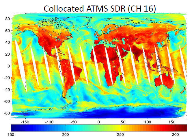 Global image of collocated ATMS SDR channel 16. Courtesy of the JPSS LTM system.
The Advanced Technology Microwave Sounder (ATMS) on board Suomi
NPP, NOAA-20, and NOAA-21 is a 22 channel microwave sounder that provides continuous
cross-track scanning in an 824 km sun-synchronous orbit. This Sensor Data Record
(SDR) from ATMS provides Level 1b calibrated and geolocated radiance data produced
from the ATMS Raw Data Record (RDR) and Temperature Data Record (TDR). This
operational SDR is used to produce ATMS Environmental Data Records (EDR) for
measuring atmospheric temperature and moisture. ATMS SDR data obtained from the NOAA
Comprehensive Large Array-Data Stewardship System (CLASS) are distributed as
aggregated 8 minute files consisting of 15 granules in the Hierarchical Data Format
v.5 (HDF5) with metadata attributes included.
- Cite as: Weng, Fuzhong, Sun, Ninghai, Qiu, Shuang, and NOAA
JPSS Program Office (2011): NOAA JPSS Advanced Technology Microwave Sounder
(ATMS) Sensor Data Record (SDR) from IDPS. [indicate subset used]. NOAA
National Centers for Environmental Information. doi:10.7289/V5BR8Q7N [access
date].
| Download Data |
-
NOAA CLASS FTP Server (download)
Access and download data tar files by date and product for the previous 85 days. The directory structure is as follows, date(yyyymmdd)->instrument family->product.
|
| Order Data |
|
| Distribution Formats |
|
| Ordering Instructions |
Contact NCEI for other distribution options and instructions. |
| Distributor |
NOAA National Centers for Environmental Information
ncei.info@noaa.gov
|
| Dataset Point of Contact |
DOC/NOAA/NESDIS/NCEI > National Centers for Environmental Information, NESDIS, NOAA, U.S. Department of Commerce
ncei.sat.info@noaa.gov
|
| Time Period |
2011-11-08 to Present (time interval: 12-hour) |
| Spatial Reference System |
urn:ogc:def:crs:EPSG::4326 |
| Spatial Bounding Box Coordinates |
West: -180.0
East: 180.0
South: -90.0
North: 90.0
|
| Spatial Coverage Map |
|
| General Documentation |
|
| Processing Documents |
- JPSS STAR Science Documents
- JPSS STAR Algorithm Maturity Matrix
|
| Associated Resources |
- Data Stewardship Maturity Report for NOAA JPSS Advanced Technology Microwave Sounder (ATMS) Sensor Data Record (SDR) from IDPS
- Data Stewardship Maturity Report for NOAA JPSS Advanced Technology Microwave Sounder (ATMS) Sensor Data Record (SDR) from IDPS
- NPP ATMS prelaunch performance assessment and Sensor Data Record validation
-
Conference paper published July 2011 by IEEE (Geoscience and Remote Sensing Symposium)
Blackwell, W., Chidester, L., et al., (2011), NPP ATMS Prelaunch Performance Assessment and Sensor Data Record Validation, Geo. and Rem. Sens. Symp., conference paper presented at 2011 IEEE International, Vancouver, BC, Canada, doi:10.1109/IGARSS.2011.6048890.
- On Convertibility From Antenna to Sensor Brightness Temperature for ATMS
-
Journal article published July 2013 by IEEE (Geoscience and Remote Sensing Letters)
Weng, F., Yang, H., et al., (2012), On Convertibility from Antenna to Sensor Brightness Temperature for ATMS, IEEE Geo. and Rem. Sens. Let., 10(4), 771—775, doi:10.1109/LGRS.2012.2223193.
|
| Publication Dates |
|
| Edition |
Provisional |
| Data Presentation Form |
Digital image
|
| Dataset Progress Status |
Ongoing - data is continually being updated |
| Data Update Frequency |
Continual |
| Purpose |
The data products derived from this dataset include: surface temp, rain rate, sea ice snow cover, TPW, IWP, CLW, and emissivity products. |
| Use Limitations |
- For a complete list of limitations see the Algorithm Theoretical Basis Document (ATBD).
|
| Dataset Citation |
- Cite as: Weng, Fuzhong, Sun, Ninghai, Qiu, Shuang, and NOAA JPSS Program Office (2011): NOAA JPSS Advanced Technology Microwave Sounder (ATMS) Sensor Data Record (SDR) from IDPS. [indicate subset used]. NOAA National Centers for Environmental Information. doi:10.7289/V5BR8Q7N [access date].
|
| Cited Authors |
- NOAA JPSS Program Office
- Sun, Ninghai
DOC/NOAA/NESDIS/STAR > Center for Satellite Applications and Research, NESDIS, NOAA, U.S. Department of Commerce
- Qiu, Shuang
DOC/NOAA/NESDIS/OSPO > Office of Satellite and Product Operations, Center for Satellite Applications and Research, NESDIS, NOAA, U.S. Department of Commerce
- Weng, Fuzhong
DOC/NOAA/NESDIS/STAR > Center for Satellite Applications and Research, NESDIS, NOAA, U.S. Department of Commerce
|
| Originators |
|
| Principal Investigators |
- Sun, Ninghai
DOC/NOAA/NESDIS/STAR > Center for Satellite Applications and Research, NESDIS, NOAA, U.S. Department of Commerce
- Qiu, Shuang
DOC/NOAA/NESDIS/OSPO > Office of Satellite and Product Operations, Center for Satellite Applications and Research, NESDIS, NOAA, U.S. Department of Commerce
- Weng, Fuzhong
DOC/NOAA/NESDIS/STAR > Center for Satellite Applications and Research, NESDIS, NOAA, U.S. Department of Commerce
|
| Publishers |
- NOAA National Centers for Environmental Information
|
| Theme keywords |
Global Change Master Directory (GCMD) Science Keywords
- Earth Science > Spectral/Engineering > Microwave > microwave radiance
- Earth Science > Spectral/Engineering > Microwave > brightness temperature
- Earth Science > Spectral/Engineering > Microwave > sensor counts
|
| Data Center keywords |
Global Change Master Directory (GCMD) Data Center Keywords
- DOC/NOAA/NESDIS/NCDC > National Climatic Data Center, NESDIS, NOAA, U.S. Department of Commerce
- DOC/NOAA/NESDIS/NCEI > National Centers for Environmental Information, NESDIS, NOAA, U.S. Department of Commerce
- DOC/NOAA/NESDIS/STAR > Center for Satellite Applications and Research, NESDIS, NOAA, U.S. Department of Commerce
- DOC/NOAA/NESDIS/OSPO > Office of Satellite and Product Operations, NESDIS, NOAA, U.S. Department of Commerce
|
| Platform keywords |
Global Change Master Directory (GCMD) Platform Keywords
- SUOMI-NPP > Suomi National Polar-orbiting Partnership
- NOAA-20 > National Oceanic and Atmospheric Administration - 20
- NOAA-21 > National Oceanic and Atmospheric Administration - 21
|
| Instrument keywords |
Global Change Master Directory (GCMD) Instrument Keywords- ATMS > Advanced Technology Microwave Sounder
|
| Place keywords |
Global Change Master Directory (GCMD) Location Keywords- Geographic Region > Global
|
| Project keywords |
NOAA STAR Central Data Repository (SCDR) Names
|
| Data Resolution keywords |
Global Change Master Directory (GCMD) Data Resolution Keywords
|
| Stratum keywords |
Global Change Master Directory (GCMD) Data Vertical Location Keywords
- Vertical Location > Troposphere
- Vertical Location > Stratosphere
|
| Use Constraints |
- Cite as: Weng, Fuzhong, Sun, Ninghai, Qiu, Shuang, and NOAA JPSS Program Office (2011): NOAA JPSS Advanced Technology Microwave Sounder (ATMS) Sensor Data Record (SDR) from IDPS. [indicate subset used]. NOAA National Centers for Environmental Information. doi:10.7289/V5BR8Q7N [access date].
- Use liability: NOAA and NCEI cannot provide any warranty as to the accuracy, reliability, or completeness of furnished data. Users assume responsibility to determine the usability of these data. The user is responsible for the results of any application of this data for other than its intended purpose.
|
| Access Constraints |
- Distribution liability: NOAA and NCEI make no warranty, expressed or implied, regarding these data, nor does the fact of distribution constitute such a warranty. NOAA and NCEI cannot assume liability for any damages caused by any errors or omissions in these data. If appropriate, NCEI can only certify that the data it distributes are an authentic copy of the records that were accepted for inclusion in the NCEI archives.
|
| Fees |
- In most cases, electronic downloads of the data are free. However, fees may apply for custom orders, data certifications, copies of analog materials, and data distribution on physical media.
|
| Lineage information for: dataset |
|---|
| Lineage Statement |
These data were produced by the JPSS Interface Data Processing Segment (IDPS) and are archived at the NOAA National Centers for Environmental Information (NCEI). |
| Processor |
- DOC/NOAA/NESDIS/STAR > Center for Satellite Applications and Research, NESDIS, NOAA, U.S. Department of Commerce
|
| Processing Steps |
- For a complete description of the processing steps, see the Algorithm Theoretical Basis Document and Data Flow Diagram.
- 2012-01-13T00:00:00 - The S-NPP ATMS SDR algorithm reached Beta maturity status.
- 2012-10-23T00:00:00 - The S-NPP ATMS SDR algorithm reached Provisional maturity status.
- 2013-12-18T00:00:00 - The S-NPP ATMS SDR algorithm reached Validated maturity status.
- 2017-12-08T00:00:00 - The NOAA-20 ATMS SDR algorithm reached Beta maturity status.
- 2018-01-23T00:00:00 - The NOAA-20 ATMS SDR algorithm reached Provisional maturity status.
- 2018-07-05T00:00:00 - The NOAA-20 ATMS SDR algorithm reached Validated maturity status.
- 2022-11-30T00:00:00 - The NOAA-21 ATMS SDR algorithm reached Beta maturity status.
- 2022-12-15T00:00:00 - The NOAA-21 ATMS SDR algorithm reached Provisional maturity status.
|
| Processing Documents |
- JPSS STAR Science Documents
- JPSS STAR Algorithm Maturity Matrix
|
| Source Datasets |
- NOAA JPSS Advanced Technology Microwave Sounder (ATMS) Raw Data Record (RDR)
-
Resource page for ATMS-RDR
Source data set landing page with general information and access links for the data set.
- Description of Source: Raw Data Record (RDR)
- Temporal extent used: 2012-12-10 to Present
- Spatial extent used: N:90 S:-90 E:180 W:-180
- NOAA JPSS Advanced Technology Microwave Sounder (ATMS) Temperature Data Record (TDR) from IDPS
-
NCEI landing page for ATMS-TDR
Source data set landing page with general information and access links for the data set.
- Description of Source: Temperature Data Record (TDR)
- Temporal extent used: 2011-12-10 to Present
- Spatial extent used: N:90 S:-90 E:180 W:-180
|
| Lineage information for: repository |
|---|
| Processing Steps |
- 2015-04-22T00:00:00 - NOAA created the National Centers for Environmental Information (NCEI) by merging NOAA's National Climatic Data Center (NCDC), National Geophysical Data Center (NGDC), and National Oceanographic Data Center (NODC), including the National Coastal Data Development Center (NCDDC), per the Consolidated and Further Continuing Appropriations Act, 2015, Public Law 113-235. NCEI launched publicly on April 22, 2015.
|
Last Modified: 2023-09-18
For questions about the information on this page, please email:
ncei.info@noaa.gov