NOAA JPSS Visible Infrared Imaging Radiometer Suite (VIIRS) Cloud Mask Environmental Data Record (EDR) from NDE
JPSS-ECM-NDE
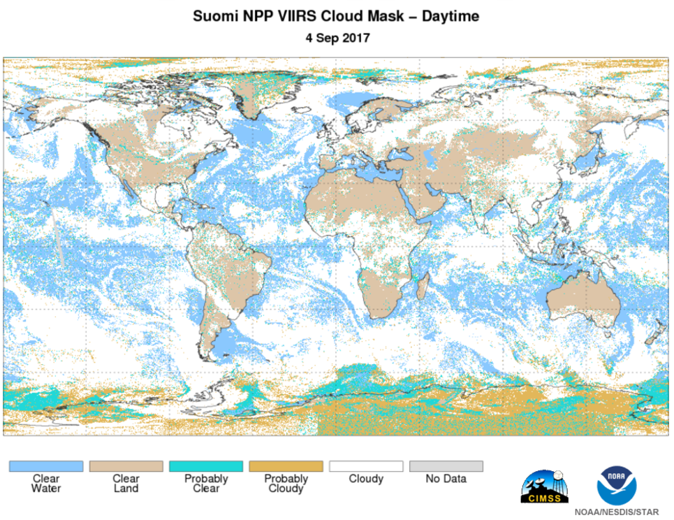 Global image of Suomi NPP VIIRS Cloud Mask during daytime on September 4th, 2017. Image courtesy of JPSS LTM system.
This data set contains a high quality Environmental Data Record (EDR) of cloud masks from the Visible Infrared Imaging Radiometer Suite (VIIRS) instrument onboard the Suomi-NPP satellite and is produced by the NOAA Satellite and Information Service (NESDIS). The EDR contains an image in the form of a binary cloud mask that identifies pixels within a coverage region as clear or cloudy. The production of the clear sky mask is an important step in the processing of many other VIIRS products that use the information generated in the production of the clear sky mask to determine the presence of clouds. Additionally, the product includes data quality information for the binary cloud mask data values for on-earth pixels. The algorithm utilizes 13 VIIRS bands from 0.415µm to 12.02µm including the VIIRS Day Night Band (DNB). The EDR provides global coverage approximately every 12 hours at a spatial resolution of 750 meters at nadir. VIIRS Cloud Mask data distributed by the NESDIS Data Exploitation (NDE) system and obtained from the Comprehensive Large-Array Stewardship System (CLASS) are distributed as single 86-second granules in NetCDF-4 format with metadata attributes included.
- Cite as: Heidinger, Andrew, Donahue, David, and JPSS Program Office (2017): NOAA JPSS Visible Infrared Imaging Radiometer Suite (VIIRS) Cloud Mask Environmental Data Record (EDR) from NDE. [indicate subset used]. NOAA National Centers for Environmental Information. doi:10.7289/V5QR4VBJ. [access date].
| Download Data |
-
NOAA CLASS FTP Server (download)
Access and download data tar files by date and product for the previous 85 days. The directory structure is as follows, date(yyyymmdd)->instrument family->product.
|
| Order Data |
|
| Distribution Formats |
|
| Ordering Instructions |
Contact NCEI for other distribution options and instructions. |
| Distributor |
NOAA National Centers for Environmental Information
ncei.info@noaa.gov
|
| Dataset Point of Contact |
Customer Engagement Branch
NOAA National Centers for Environmental Information
1-828-271-4800
ncei.orders@noaa.gov
|
| Time Period |
2017-07-06 to Present (time interval: 12-hour) |
| Spatial Reference System |
urn:ogc:def:crs:EPSG::4326 |
| Spatial Bounding Box Coordinates |
West: -180.0
East: 180.0
South: -90.0
North: 90.0
|
| Spatial Coverage Map |
|
| General Documentation |
|
| Processing Documents |
- JPSS STAR Science Documents
- JPSS STAR Algorithm Maturity Matrix
|
| Associated Resources |
- The VIIRS Cloud Mask: Progress in the first year of S-NPP toward a common cloud detection scheme
-
Journal article published March 2014 by Wiley (Journal of Geophysical Research Atmospheres)
Kopp, T., Thomas, W., et al., (2014), The VIIRS Cloud Mask: Progress in the First Year of S-NPP Toward a Common Cloud Detection Scheme, J. of Geo. Res. Atm., 119(5), 2441-2456, doi:10.1002/2013JD020458.
|
| Publication Dates |
|
| Edition |
Validated |
| Data Presentation Form |
Digital image
|
| Dataset Progress Status |
Ongoing - data is continually being updated |
| Data Update Frequency |
Continual |
| Purpose |
The VIIRS cloud mask is an essential input in many downstream algorithms and products. |
| Use Limitations |
- For a complete description of use limitations for this EDR, see the Algorithm Theoretical Basis Document (ATBD).
|
| Dataset Citation |
- Cite as: Heidinger, Andrew, Donahue, David, and JPSS Program Office (2017): NOAA JPSS Visible Infrared Imaging Radiometer Suite (VIIRS) Cloud Mask Environmental Data Record (EDR) from NDE. [indicate subset used]. NOAA National Centers for Environmental Information. doi:10.7289/V5QR4VBJ. [access date].
|
| Cited Authors |
- Heidinger, Andrew
DOC/NOAA/NESDIS/STAR > Center for Satellite Applications and Research, NESDIS, NOAA, U.S. Department of Commerce
- Donahue, David
DOC/NOAA/NESDIS/OSPO > Office of Satellite and Product Operations, NESDIS, NOAA, U.S. Department of Commerce
- NOAA JPSS Program Office
|
| Principal Investigators |
- Heidinger, Andrew
DOC/NOAA/NESDIS/STAR > Center for Satellite Applications and Research, NESDIS, NOAA, U.S. Department of Commerce
- Donahue, David
DOC/NOAA/NESDIS/OSPO > Office of Satellite and Product Operations, NESDIS, NOAA, U.S. Department of Commerce
|
| Resource Providers |
|
| Publishers |
- NOAA National Centers for Environmental Information
|
| Theme keywords |
Global Change Master Directory (GCMD) Science Keywords- Earth Science > Atmosphere > Clouds > Cloud Properties > Cloud Fraction
Global Climate Observing System (GCOS) Essential Climate Variables (ECVs)- Atmospheric - Upper-air - Cloud Properties
Keyword Thesaurus Title
- Nde > Nesdis Data Exploitation
- Edr > Environmental Data Record
|
| Data Center keywords |
Global Change Master Directory (GCMD) Data Center Keywords
- DOC/NOAA/NESDIS/STAR > Center for Satellite Applications and Research, NESDIS, NOAA, U.S. Department of Commerce
- DOC/NOAA/NESDIS/NCDC > National Climatic Data Center, NESDIS, NOAA, U.S. Department of Commerce
- DOC/NOAA/NESDIS/NCEI > National Centers for Environmental Information, NESDIS, NOAA, U.S. Department of Commerce
- DOC/NOAA/NESDIS/OSPO > Office of Satellite and Product Operations, NESDIS, NOAA, U.S. Department of Commerce
|
| Platform keywords |
Global Change Master Directory (GCMD) Platform Keywords
- SUOMI-NPP > Suomi National Polar-orbiting Partnership
- NOAA-20 > Joint Polar Satellite System - 1
|
| Instrument keywords |
Global Change Master Directory (GCMD) Instrument Keywords- VIIRS > Visible-Infrared Imager-Radiometer Suite
|
| Place keywords |
Global Change Master Directory (GCMD) Location Keywords- Geographic Region > Global
|
| Project keywords |
Global Change Master Directory (GCMD) Project Keywords
- NOAA OneStop Project
- JPSS > Joint Polar Satellite System
|
| Data Resolution keywords |
Global Change Master Directory (GCMD) Horizontal Data Resolution Keywords
|
| Stratum keywords |
Global Change Master Directory (GCMD) Location Keywords- Vertical Location > Troposphere
|
| Use Constraints |
- Cite as: Heidinger, Andrew, Donahue, David, and JPSS Program Office (2017): NOAA JPSS Visible Infrared Imaging Radiometer Suite (VIIRS) Cloud Mask Environmental Data Record (EDR) from NDE. [indicate subset used]. NOAA National Centers for Environmental Information. doi:10.7289/V5QR4VBJ. [access date].
- Use liability: NOAA and NCEI cannot provide any warranty as to the accuracy, reliability, or completeness of furnished data. Users assume responsibility to determine the usability of these data. The user is responsible for the results of any application of this data for other than its intended purpose.
|
| Access Constraints |
- Distribution liability: NOAA and NCEI make no warranty, expressed or implied, regarding these data, nor does the fact of distribution constitute such a warranty. NOAA and NCEI cannot assume liability for any damages caused by any errors or omissions in these data. If appropriate, NCEI can only certify that the data it distributes are an authentic copy of the records that were accepted for inclusion in the NCEI archives.
|
| Fees |
- In most cases, electronic downloads of the data are free. However, fees may apply for custom orders, data certifications, copies of analog materials, and data distribution on physical media.
|
| Lineage information for: dataset |
|---|
| Lineage Statement |
The data were produced by the NOAA Office of Satellite and Product Operations (OSPO) PDA and are archived at the NOAA National Centers for Environmental Information (NCEI). |
| Processor |
- DOC/NOAA/NESDIS/STAR > Center for Satellite Applications and Research, NESDIS, NOAA, U.S. Department of Commerce
|
| Processing Steps |
- For a complete description of the processing steps, see the Algorithm Theoretical Basis Document and Data Flow Diagram.
- 2013-04-05T00:00:00 - The S-NPP VIIRS Cloud Mask algorithm reached beta maturity.
- 2015-12-15T00:00:00 - The S-NPP VIIRS Cloud Mask algorithm reached provisional maturity.
- The S-NPP VIIRS Cloud Mask algorithm reached validated maturity.
- 2018-04-18T00:00:00 - The NOAA-20 VIIRS Cloud Mask algorithm reached beta maturity.
- 2018-10-02T00:00:00 - The NOAA-20 VIIRS Cloud Mask algorithm reached provisional maturity.
- 2019-05-16T00:00:00 - The NOAA-20 VIIRS Cloud Mask algorithm reached validated maturity.
|
| Processing Documents |
- JPSS STAR Science Documents
- JPSS STAR Algorithm Maturity Matrix
|
| Source Datasets |
- NOAA JPSS Visible Infrared Imaging Radiometer Suite (VIIRS) Sensor Data Record (SDR) from IDPS
-
NCEI landing page for JPSS-VIIRS-SDR
Source dataset landing page with general information and access links for the dataset.
- Description of Source: Sensor Data Record (SDR)
- Temporal extent used: 2012-02-07 to Present
- Spatial extent used: N:90 S:-90 E:180 W:-180
|
| Lineage information for: repository |
|---|
| Processing Steps |
- 2015-04-22T00:00:00 - NOAA created the National Centers for Environmental Information (NCEI) by merging NOAA's National Climatic Data Center (NCDC), National Geophysical Data Center (NGDC), and National Oceanographic Data Center (NODC), including the National Coastal Data Development Center (NCDDC), per the Consolidated and Further Continuing Appropriations Act, 2015, Public Law 113-235. NCEI launched publicly on April 22, 2015.
|
Last Modified: 2023-06-23
For questions about the information on this page, please email:
ncei.info@noaa.gov