NOAA JPSS Visible Infrared Imaging Radiometer Suite (VIIRS) Daytime Cloud Optical and Microphysical Properties (DCOMP) from NDE
VIIRS-DCOMP-NDE
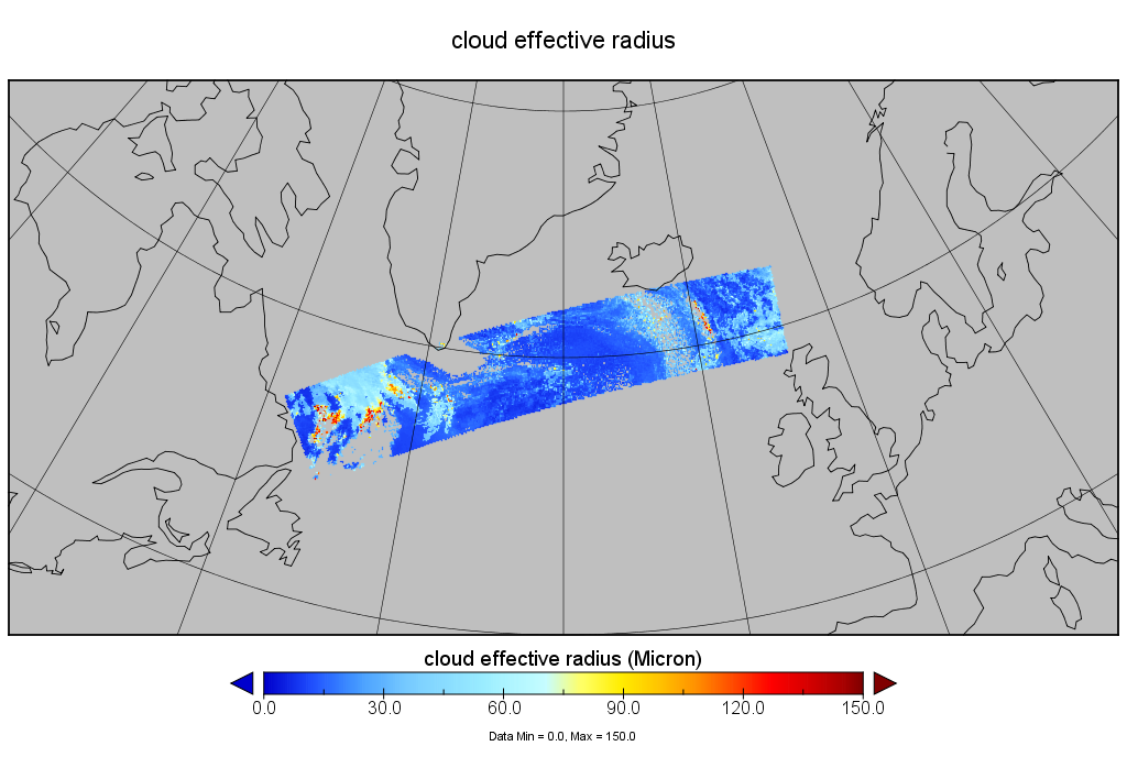 Example of VIIRS NDE Cloud Effective Radius (Microphysical Properties) over the North Atlantic on July 7, 2017. Courtesy of JPSS LTM program.
This data set contains a high quality Environmental Data Record (EDR) of daytime cloud optical and microphysical properties (DCOMP) from the Visible Infrared Imaging Radiometer Suite (VIIRS) instrument onboard the Suomi-NPP satellite and is produced by the NOAA Environmental Satellite, Data, and Information Service (NESDIS). The EDR contains Cloud Optical Depth (COD), Cloud effective Particle Size (CPS), and Liquid and Ice Water Path (LWP & IWP). COD and CPS are retrieved simultaneously from observations in one visible and one near-infrared channel. The main information content for COD lies in the conservative scattering channel at about 0.6 micrometer. The absorption channel at 2.2 micrometer provides additional information on CPS and helps indirectly to estimate COD by adjusting the difference in the phase function due to particle size. Liquid and ice water path are calculated subsequently from COD and CPS. The EDR provides global coverage daily at a spatial resolution of 750 meters at nadir. VIIRS DCOMP data distributed by the NESDIS Data Exploitation (NDE) system and obtained from the Comprehensive Large-Array Stewardship System (CLASS) are distributed as single 86-second granules in NetCDF-4 format with metadata attributes included.
- Cite as: Heidinger, Andrew, Walther, Andi, Donahue, David, and NOAA JPSS Program Office (2017): NOAA JPSS Visible Infrared Imaging Radiometer Suite (VIIRS) Daytime Cloud Optical and Microphysical Properties (DCOMP) from NDE. [indicate subset used]. NOAA National Centers for Environmental Information. doi:10.7289/V5VH5M28. [access date].
| Download Data |
-
NOAA CLASS FTP Server (download)
Access and download data tar files by date and product for the previous 85 days. The directory structure is as follows, date(yyyymmdd)->instrument family->product.
|
| Order Data |
|
| Distribution Formats |
|
| Ordering Instructions |
Contact NCEI for other distribution options and instructions. |
| Distributor |
NOAA National Centers for Environmental Information
ncei.info@noaa.gov
|
| Dataset Point of Contact |
Customer Engagement Branch
DOC/NOAA/NESDIS/NCEI > National Centers for Environmental Information, NESDIS, NOAA, U.S. Department of Commerce
ncei.sat.info@noaa.gov
|
| Time Period |
2017-07-06 to Present (time interval: 24-hour) |
| Spatial Reference System |
urn:ogc:def:crs:EPSG::4326 |
| Spatial Bounding Box Coordinates |
West: -180.0
East: 180.0
South: -90.0
North: 90.0
|
| Spatial Coverage Map |
|
| General Documentation |
|
| Processing Documents |
- JPSS STAR Science Documents
- JPSS STAR Algorithm Maturity Matrix
|
| Associated Resources |
- The expected performance of cloud optical and microphysical properties derived from Suomi NPP VIIRS day/night band lunar reflectance.
-
Journal article published December 2013 by Wiley (Journal of Geophysical Research Atmospheres)
Walther, A., Heidinger, A., et al., (2013), The expected performance of cloud optical microphysical properties derived from Suomi NPP VIIRS day/night band lunar reflectance, J. Geo. Res. Atmo., 118(23), 13230—13240, doi:10.1002/2013JD020478.
|
| Publication Dates |
|
| Edition |
Validated |
| Data Presentation Form |
Digital image
|
| Dataset Progress Status |
Ongoing - data is continually being updated |
| Data Update Frequency |
Continual |
| Purpose |
The VIIRS DCOMP product is used to parameterize clouds in global climate models. Precise retrievals are critical to improving climate models. |
| Use Limitations |
- For a complete description of use limitations for this EDR, see the Algorithm Theoretical Basis Document (ATBD).
|
| Dataset Citation |
- Cite as: Heidinger, Andrew, Walther, Andi, Donahue, David, and NOAA JPSS Program Office (2017): NOAA JPSS Visible Infrared Imaging Radiometer Suite (VIIRS) Daytime Cloud Optical and Microphysical Properties (DCOMP) from NDE. [indicate subset used]. NOAA National Centers for Environmental Information. doi:10.7289/V5VH5M28. [access date].
|
| Cited Authors |
- Walther, Andi
UWI-MAD/SSEC/CIMSS > Cooperative Institute for Meteorological Satellite Studies, Space Science and Engineering Center, University of Wisconsin, Madison
- Heidinger, Andrew
DOC/NOAA/NESDIS/STAR > Center for Satellite Applications and Research, NESDIS, NOAA, U.S. Department of Commerce
- Donahue, David
DOC/NOAA/NESDIS/OSPO > Office of Satellite and Product Operations, NESDIS, NOAA, U.S. Department of Commerce
- NOAA JPSS Program Office
|
| Principal Investigators |
- Walther, Andi
UWI-MAD/SSEC/CIMSS > Cooperative Institute for Meteorological Satellite Studies, Space Science and Engineering Center, University of Wisconsin, Madison
- Heidinger, Andrew
DOC/NOAA/NESDIS/STAR > Center for Satellite Applications and Research, NESDIS, NOAA, U.S. Department of Commerce
- Donahue, David
DOC/NOAA/NESDIS/OSPO > Office of Satellite and Product Operations, NESDIS, NOAA, U.S. Department of Commerce
|
| Resource Providers |
|
| Publishers |
- NOAA National Centers for Environmental Information
|
| Theme keywords |
Global Change Master Directory (GCMD) Science Keywords
- Earth Science > Atmosphere > Clouds > Cloud Microphysics > Cloud Optical Depth/Thickness
- Earth Science > Atmosphere > Clouds > Cloud Microphysics > Cloud Liquid Water/Ice
- Earth Science > Atmosphere > Clouds > Cloud Microphysics > Particle Size Distribution
Global Climate Observing System (GCOS) Essential Climate Variables (ECVs)- Atmospheric - Upper-air - Cloud Properties
Keyword Thesaurus Title
- Nde > Nesdis Data Exploitation
- Edr > Environmental Data Record
|
| Data Center keywords |
Global Change Master Directory (GCMD) Data Center Keywords
- DOC/NOAA/NESDIS/STAR > Center for Satellite Applications and Research, NESDIS, NOAA, U.S. Department of Commerce
- DOC/NOAA/NESDIS/NCDC > National Climatic Data Center, NESDIS, NOAA, U.S. Department of Commerce
- DOC/NOAA/NESDIS/NCEI > National Centers for Environmental Information, NESDIS, NOAA, U.S. Department of Commerce
- DOC/NOAA/NESDIS/OSPO > Office of Satellite and Product Operations, NESDIS, NOAA, U.S. Department of Commerce
|
| Platform keywords |
Global Change Master Directory (GCMD) Platform Keywords
- SUOMI-NPP > Suomi National Polar-orbiting Partnership
- NOAA-20 > Joint Polar Satellite System -1
|
| Instrument keywords |
Global Change Master Directory (GCMD) Instrument Keywords- VIIRS > Visible-Infrared Imager-Radiometer Suite
|
| Place keywords |
Global Change Master Directory (GCMD) Location Keywords- Geographic Region > Global
|
| Project keywords |
Global Change Master Directory (GCMD) Project Keywords
- NOAA OneStop Project
- JPSS > Joint Polar Satellite System
|
| Data Resolution keywords |
Global Change Master Directory (GCMD) Horizontal Data Resolution Keywords
|
| Stratum keywords |
Global Change Master Directory (GCMD) Location Keywords- Vertical Location > Troposphere
|
| Use Constraints |
- Cite as: Heidinger, Andrew, Walther, Andi, Donahue, David, and NOAA JPSS Program Office (2017): NOAA JPSS Visible Infrared Imaging Radiometer Suite (VIIRS) Daytime Cloud Optical and Microphysical Properties (DCOMP) from NDE. [indicate subset used]. NOAA National Centers for Environmental Information. doi:10.7289/V5VH5M28. [access date].
- Use liability: NOAA and NCEI cannot provide any warranty as to the accuracy, reliability, or completeness of furnished data. Users assume responsibility to determine the usability of these data. The user is responsible for the results of any application of this data for other than its intended purpose.
|
| Access Constraints |
- Distribution liability: NOAA and NCEI make no warranty, expressed or implied, regarding these data, nor does the fact of distribution constitute such a warranty. NOAA and NCEI cannot assume liability for any damages caused by any errors or omissions in these data. If appropriate, NCEI can only certify that the data it distributes are an authentic copy of the records that were accepted for inclusion in the NCEI archives.
|
| Fees |
- In most cases, electronic downloads of the data are free. However, fees may apply for custom orders, data certifications, copies of analog materials, and data distribution on physical media.
|
| Lineage information for: dataset |
|---|
| Lineage Statement |
The data were produced by the NOAA Office of Satellite and Product Operations (OSPO) NDE/PDA and are archived at the NOAA National Centers for Environmental Information (NCEI). |
| Processor |
- DOC/NOAA/NESDIS/STAR > Center for Satellite Applications and Research, NESDIS, NOAA, U.S. Department of Commerce
|
| Processing Steps |
- For a complete description of the processing steps, see the Algorithm Theoretical Basis Document and Data Flow Diagram.
- 2014-11-12T00:00:00 - The S-NPP VIIRS Enterprise Daytime Cloud Optical and Microphysical Properties algorithm reached beta maturity.
- 2015-12-15T00:00:00 - The S-NPP VIIRS Enterprise Daytime Cloud Optical and Microphysical Properties algorithm reached provisional maturity.
- 2016-07-08T00:00:00 - The S-NPP VIIRS Enterprise Daytime Cloud Optical and Microphysical Properties algorithm reached validated maturity.
- 2018-07-23T00:00:00 - The NOAA-20 VIIRS Enterprise Daytime Cloud Optical and Microphysical Properties algorithm reached beta maturity.
- 2018-11-27T00:00:00 - The NOAA-20 VIIRS Enterprise Daytime Cloud Optical and Microphysical Properties algorithm reached provisional maturity.
- 2019-05-16T00:00:00 - The NOAA-20 VIIRS Enterprise Daytime Cloud Optical and Microphysical Properties algorithm reached validated maturity.
|
| Processing Documents |
- JPSS STAR Science Documents
- JPSS STAR Algorithm Maturity Matrix
|
| Source Datasets |
- NOAA JPSS Visible Infrared Imaging Radiometer Suite (VIIRS) Sensor Data Record (SDR) from IDPS
-
NCEI landing page for JPSS-VIIRS-SDR
Source dataset landing page with general information and access links for the dataset.
- Description of Source: Sensor Data Record (SDR) from VIIRS bands M5, M8, M10, M11, and M12
- Temporal extent used: 2012-02-07 to Present
- Spatial extent used: N:90 S:-90 E:180 W:-180
|
| Lineage information for: repository |
|---|
| Processing Steps |
- 2015-04-22T00:00:00 - NOAA created the National Centers for Environmental Information (NCEI) by merging NOAA's National Climatic Data Center (NCDC), National Geophysical Data Center (NGDC), and National Oceanographic Data Center (NODC), including the National Coastal Data Development Center (NCDDC), per the Consolidated and Further Continuing Appropriations Act, 2015, Public Law 113-235. NCEI launched publicly on April 22, 2015.
|
Last Modified: 2023-06-23
For questions about the information on this page, please email:
ncei.info@noaa.gov