NOAA JPSS Visible Infrared Imaging Radiometer Suite (VIIRS) Daytime Cloud Optical and Microphysical Properties (DCOMP) from NDE
- referenceSystemInfo
- identificationInfo
- contentInfo
- distributionInfo
- dataQualityInfo
- dataQualityInfo
- dataQualityInfo
- metadataMaintenance
(MI_Metadata)
fileIdentifier: gov.noaa.ncdc:C01437
language: eng; USA
characterSet: (MD_CharacterSetCode) utf8
hierarchyLevel: (MD_ScopeCode) dataset
contact: (CI_ResponsibleParty)
organisationName: NOAA National Centers for Environmental Information
contactInfo: (CI_Contact)
address: (CI_Address)
electronicMailAddress: ncei.info@noaa.gov
onlineResource: (CI_OnlineResource)
linkage: https://www.ncei.noaa.gov/contact
name: NCEI Contact Information
description: Information for contacts at NCEI.
function: (CI_OnLineFunctionCode) information
role: (CI_RoleCode) pointOfContact
dateStamp: 2023-06-23
metadataStandardName: ISO 19115-2 Geographic Information - Metadata - Part 2: Extensions for Imagery and Gridded Data
metadataStandardVersion: ISO 19115-2:2009(E)
return to top
referenceSystemInfo: (MD_ReferenceSystem)
referenceSystemIdentifier: (RS_Identifier)
authority: (CI_Citation)
title: EPSG Geodetic Parameter Dataset Registry
date: (CI_Date)
date: 2008-11-12
dateType: (CI_DateTypeCode) publication
citedResponsibleParty: (CI_ResponsibleParty)
organisationName: International Association of Oil and Gas Producers (OGP) Geomatics Committee
contactInfo: (CI_Contact)
onlineResource: (CI_OnlineResource)
linkage: http://www.epsg-registry.org/
applicationProfile: Data Search Application
name: EPSG Geodetic Parameter Dataset Registry Application
description: Interface to the EPSG Geodetic Parameter Dataset Registry
function: (CI_OnLineFunctionCode) search
role: (CI_RoleCode) custodian
citedResponsibleParty: (CI_ResponsibleParty)
organisationName: International Association of Oil and Gas Producers (OGP) Geomatics Committee
contactInfo: (CI_Contact)
onlineResource: (CI_OnlineResource)
linkage: http://www.epsg-registry.org/export.htm?gml=urn:ogc:def:crs:EPSG::4326
applicationProfile: Download
name: Coordinate Reference System data in GML
description: Coordinate Reference System data in GML
function: (CI_OnLineFunctionCode) download
role: (CI_RoleCode) custodian
code: urn:ogc:def:crs:EPSG::4326
version: (unknown)
return to top
identificationInfo: (MD_DataIdentification)
citation: (CI_Citation)
title: NOAA JPSS Visible Infrared Imaging Radiometer Suite (VIIRS) Daytime Cloud Optical and Microphysical Properties (DCOMP) from NDE
alternateTitle: VIIRS-DCOMP-NDE
date: (CI_Date)
date: 2018-08-28
dateType: (CI_DateTypeCode) publication
edition: Validated
identifier: (MD_Identifier)
code:
Anchor: DOI doi:10.7289/V5VH5M28
identifier: (MD_Identifier)
code: gov.noaa.ncdc:C01437
identifier: (MD_Identifier)
code: gov.noaa.class:JPSS_GRAN
citedResponsibleParty: (CI_ResponsibleParty)
organisationName: NOAA National Centers for Environmental Information
role: (CI_RoleCode) publisher
citedResponsibleParty: (CI_ResponsibleParty)
individualName: Walther, Andi
organisationName: UWI-MAD/SSEC/CIMSS > Cooperative Institute for Meteorological Satellite Studies, Space Science and Engineering Center, University of Wisconsin, Madison
role: (CI_RoleCode) principalInvestigator
citedResponsibleParty: (CI_ResponsibleParty)
individualName: Walther, Andi
organisationName: UWI-MAD/SSEC/CIMSS > Cooperative Institute for Meteorological Satellite Studies, Space Science and Engineering Center, University of Wisconsin, Madison
role: (CI_RoleCode) author
citedResponsibleParty: (CI_ResponsibleParty)
individualName: Heidinger, Andrew
organisationName: DOC/NOAA/NESDIS/STAR > Center for Satellite Applications and Research, NESDIS, NOAA, U.S. Department of Commerce
role: (CI_RoleCode) principalInvestigator
citedResponsibleParty: (CI_ResponsibleParty)
individualName: Heidinger, Andrew
organisationName: DOC/NOAA/NESDIS/STAR > Center for Satellite Applications and Research, NESDIS, NOAA, U.S. Department of Commerce
role: (CI_RoleCode) author
citedResponsibleParty: (CI_ResponsibleParty)
individualName: Donahue, David
organisationName: DOC/NOAA/NESDIS/OSPO > Office of Satellite and Product Operations, NESDIS, NOAA, U.S. Department of Commerce
role: (CI_RoleCode) principalInvestigator
citedResponsibleParty: (CI_ResponsibleParty)
individualName: Donahue, David
organisationName: DOC/NOAA/NESDIS/OSPO > Office of Satellite and Product Operations, NESDIS, NOAA, U.S. Department of Commerce
role: (CI_RoleCode) author
citedResponsibleParty: (CI_ResponsibleParty)
organisationName: NOAA JPSS Program Office
role: (CI_RoleCode) resourceProvider
citedResponsibleParty: (CI_ResponsibleParty)
organisationName: NOAA JPSS Program Office
role: (CI_RoleCode) author
presentationForm: (CI_PresentationFormCode) imageDigital
abstract: This data set contains a high quality Environmental Data Record (EDR) of daytime cloud optical and microphysical properties (DCOMP) from the Visible Infrared Imaging Radiometer Suite (VIIRS) instrument onboard the Suomi-NPP satellite and is produced by the NOAA Environmental Satellite, Data, and Information Service (NESDIS). The EDR contains Cloud Optical Depth (COD), Cloud effective Particle Size (CPS), and Liquid and Ice Water Path (LWP & IWP). COD and CPS are retrieved simultaneously from observations in one visible and one near-infrared channel. The main information content for COD lies in the conservative scattering channel at about 0.6 micrometer. The absorption channel at 2.2 micrometer provides additional information on CPS and helps indirectly to estimate COD by adjusting the difference in the phase function due to particle size. Liquid and ice water path are calculated subsequently from COD and CPS. The EDR provides global coverage daily at a spatial resolution of 750 meters at nadir. VIIRS DCOMP data distributed by the NESDIS Data Exploitation (NDE) system and obtained from the Comprehensive Large-Array Stewardship System (CLASS) are distributed as single 86-second granules in NetCDF-4 format with metadata attributes included.
purpose: The VIIRS DCOMP product is used to parameterize clouds in global climate models. Precise retrievals are critical to improving climate models.
status: (MD_ProgressCode) onGoing
pointOfContact: (CI_ResponsibleParty)
individualName: Customer Engagement Branch
organisationName: DOC/NOAA/NESDIS/NCEI > National Centers for Environmental Information, NESDIS, NOAA, U.S. Department of Commerce
contactInfo: (CI_Contact)
address: (CI_Address)
electronicMailAddress: ncei.sat.info@noaa.gov
role: (CI_RoleCode) pointOfContact
resourceMaintenance: (MD_MaintenanceInformation)
maintenanceAndUpdateFrequency: (MD_MaintenanceFrequencyCode) continual
graphicOverview: (MD_BrowseGraphic)
fileName: https://www.ncei.noaa.gov/pub/data/metadata/images/C01437.png
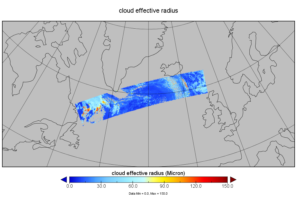
fileDescription: Example of VIIRS NDE Cloud Effective Radius (Microphysical Properties) over the North Atlantic on July 7, 2017. Courtesy of JPSS LTM program.
fileType: PNG
descriptiveKeywords: (MD_Keywords)
keyword: Earth Science > Atmosphere > Clouds > Cloud Microphysics > Cloud Optical Depth/Thickness
keyword: Earth Science > Atmosphere > Clouds > Cloud Microphysics > Cloud Liquid Water/Ice
keyword: Earth Science > Atmosphere > Clouds > Cloud Microphysics > Particle Size Distribution
type: (MD_KeywordTypeCode) theme
thesaurusName: (CI_Citation)
title: Global Change Master Directory (GCMD) Science Keywords
date: (CI_Date)
date: 2018
dateType: (CI_DateTypeCode) revision
edition: Version 8.6
citedResponsibleParty: (CI_ResponsibleParty)
organisationName: Global Change Data Center, Science and Exploration Directorate, Goddard Space Flight Center (GSFC) National Aeronautics and Space Administration (NASA)
contactInfo: (CI_Contact)
onlineResource: (CI_OnlineResource)
linkage: https://earthdata.nasa.gov/about/gcmd/global-change-master-directory-gcmd-keywords
protocol: HTTPS
applicationProfile: Web Browser
name: Global Change Master Directory (GCMD) Keywords
description: The information provided on this page seeks to define how the GCMD Keywords are structured, used and accessed. It also provides information on how users can participate in the further development of the keywords.
function: (CI_OnLineFunctionCode) information
role: (CI_RoleCode) publisher
descriptiveKeywords: (MD_Keywords)
keyword: Atmospheric - Upper-air - Cloud Properties
type: (MD_KeywordTypeCode) theme
thesaurusName: (CI_Citation)
title: Global Climate Observing System (GCOS) Essential Climate Variables (ECVs)
date: (CI_Date)
date: 2017
dateType: (CI_DateTypeCode) publication
edition: Release 2017
citedResponsibleParty: (CI_ResponsibleParty)
organisationName: World Meteorological Organization, United Nations
contactInfo: (CI_Contact)
onlineResource: (CI_OnlineResource)
linkage: https://public.wmo.int/en/programmes/global-climate-observing-system/essential-climate-variables
protocol: HTTP
applicationProfile: Information
name: GCOS Essential Climate Variables
description: Overview of the GCOS Essential Climate Variables.
function: (CI_OnLineFunctionCode) information
role: (CI_RoleCode) custodian
descriptiveKeywords: (MD_Keywords)
keyword: Geographic Region > Global
type: (MD_KeywordTypeCode) place
thesaurusName: (CI_Citation)
title: Global Change Master Directory (GCMD) Location Keywords
date: (CI_Date)
date: 2018
dateType: (CI_DateTypeCode) revision
edition: Version 8.6
citedResponsibleParty: (CI_ResponsibleParty)
organisationName: Global Change Data Center, Science and Exploration Directorate, Goddard Space Flight Center (GSFC) National Aeronautics and Space Administration (NASA)
contactInfo: (CI_Contact)
onlineResource: (CI_OnlineResource)
linkage: https://earthdata.nasa.gov/about/gcmd/global-change-master-directory-gcmd-keywords
protocol: HTTPS
applicationProfile: Web Browser
name: Global Change Master Directory (GCMD) Keywords
description: The information provided on this page seeks to define how the GCMD Keywords are structured, used and accessed. It also provides information on how users can participate in the further development of the keywords.
function: (CI_OnLineFunctionCode) information
role: (CI_RoleCode) publisher
descriptiveKeywords: (MD_Keywords)
keyword: Vertical Location > Troposphere
type: (MD_KeywordTypeCode) stratum
thesaurusName: (CI_Citation)
title: Global Change Master Directory (GCMD) Location Keywords
date: (CI_Date)
date: 2018
dateType: (CI_DateTypeCode) revision
edition: Version 8.6
citedResponsibleParty: (CI_ResponsibleParty)
organisationName: Global Change Data Center, Science and Exploration Directorate, Goddard Space Flight Center (GSFC) National Aeronautics and Space Administration (NASA)
contactInfo: (CI_Contact)
onlineResource: (CI_OnlineResource)
linkage: https://earthdata.nasa.gov/about/gcmd/global-change-master-directory-gcmd-keywords
protocol: HTTPS
applicationProfile: Web Browser
name: Global Change Master Directory (GCMD) Keywords
description: The information provided on this page seeks to define how the GCMD Keywords are structured, used and accessed. It also provides information on how users can participate in the further development of the keywords.
function: (CI_OnLineFunctionCode) information
role: (CI_RoleCode) publisher
descriptiveKeywords: (MD_Keywords)
keyword: NOAA OneStop Project
keyword: JPSS > Joint Polar Satellite System
type: (MD_KeywordTypeCode) project
thesaurusName: (CI_Citation)
title: Global Change Master Directory (GCMD) Project Keywords
date: (CI_Date)
date: 2018
dateType: (CI_DateTypeCode) revision
edition: Version 8.6
citedResponsibleParty: (CI_ResponsibleParty)
organisationName: Global Change Data Center, Science and Exploration Directorate, Goddard Space Flight Center (GSFC) National Aeronautics and Space Administration (NASA)
contactInfo: (CI_Contact)
onlineResource: (CI_OnlineResource)
linkage: https://earthdata.nasa.gov/about/gcmd/global-change-master-directory-gcmd-keywords
protocol: HTTPS
applicationProfile: Web Browser
name: Global Change Master Directory (GCMD) Keywords
description: The information provided on this page seeks to define how the GCMD Keywords are structured, used and accessed. It also provides information on how users can participate in the further development of the keywords.
function: (CI_OnLineFunctionCode) information
role: (CI_RoleCode) publisher
descriptiveKeywords: (MD_Keywords)
keyword: VIIRS > Visible-Infrared Imager-Radiometer Suite
type: (MD_KeywordTypeCode) instrument
thesaurusName: (CI_Citation)
title: Global Change Master Directory (GCMD) Instrument Keywords
date: (CI_Date)
date: 2018
dateType: (CI_DateTypeCode) revision
edition: Version 8.6
citedResponsibleParty: (CI_ResponsibleParty)
organisationName: Global Change Data Center, Science and Exploration Directorate, Goddard Space Flight Center (GSFC) National Aeronautics and Space Administration (NASA)
contactInfo: (CI_Contact)
onlineResource: (CI_OnlineResource)
linkage: https://earthdata.nasa.gov/about/gcmd/global-change-master-directory-gcmd-keywords
protocol: HTTPS
applicationProfile: Web Browser
name: Global Change Master Directory (GCMD) Keywords
description: The information provided on this page seeks to define how the GCMD Keywords are structured, used and accessed. It also provides information on how users can participate in the further development of the keywords.
function: (CI_OnLineFunctionCode) information
role: (CI_RoleCode) publisher
descriptiveKeywords: (MD_Keywords)
keyword: SUOMI-NPP > Suomi National Polar-orbiting Partnership
keyword: NOAA-20 > Joint Polar Satellite System -1
type: (MD_KeywordTypeCode) platform
thesaurusName: (CI_Citation)
title: Global Change Master Directory (GCMD) Platform Keywords
date: (CI_Date)
date: 2018
dateType: (CI_DateTypeCode) revision
edition: Version 8.6
citedResponsibleParty: (CI_ResponsibleParty)
organisationName: Global Change Data Center, Science and Exploration Directorate, Goddard Space Flight Center (GSFC) National Aeronautics and Space Administration (NASA)
contactInfo: (CI_Contact)
onlineResource: (CI_OnlineResource)
linkage: https://earthdata.nasa.gov/about/gcmd/global-change-master-directory-gcmd-keywords
protocol: HTTPS
applicationProfile: Web Browser
name: Global Change Master Directory (GCMD) Keywords
description: The information provided on this page seeks to define how the GCMD Keywords are structured, used and accessed. It also provides information on how users can participate in the further development of the keywords.
function: (CI_OnLineFunctionCode) information
role: (CI_RoleCode) publisher
descriptiveKeywords: (MD_Keywords)
keyword: 500 meters - < 1 km
type: (MD_KeywordTypeCode) dataResolution
thesaurusName: (CI_Citation)
title: Global Change Master Directory (GCMD) Horizontal Data Resolution Keywords
date: (CI_Date)
date: 2018
dateType: (CI_DateTypeCode) revision
edition: Version 8.6
citedResponsibleParty: (CI_ResponsibleParty)
organisationName: Global Change Data Center, Science and Exploration Directorate, Goddard Space Flight Center (GSFC) National Aeronautics and Space Administration (NASA)
contactInfo: (CI_Contact)
onlineResource: (CI_OnlineResource)
linkage: https://earthdata.nasa.gov/about/gcmd/global-change-master-directory-gcmd-keywords
protocol: HTTPS
applicationProfile: Web Browser
name: Global Change Master Directory (GCMD) Keywords
description: The information provided on this page seeks to define how the GCMD Keywords are structured, used and accessed. It also provides information on how users can participate in the further development of the keywords.
function: (CI_OnLineFunctionCode) information
role: (CI_RoleCode) publisher
descriptiveKeywords: (MD_Keywords)
keyword: DOC/NOAA/NESDIS/STAR > Center for Satellite Applications and Research, NESDIS, NOAA, U.S. Department of Commerce
keyword: DOC/NOAA/NESDIS/NCDC > National Climatic Data Center, NESDIS, NOAA, U.S. Department of Commerce
keyword: DOC/NOAA/NESDIS/NCEI > National Centers for Environmental Information, NESDIS, NOAA, U.S. Department of Commerce
keyword: DOC/NOAA/NESDIS/OSPO > Office of Satellite and Product Operations, NESDIS, NOAA, U.S. Department of Commerce
type: (MD_KeywordTypeCode) dataCentre
thesaurusName: (CI_Citation)
title: Global Change Master Directory (GCMD) Data Center Keywords
date: (CI_Date)
date: 2018
dateType: (CI_DateTypeCode) revision
edition: Version 8.6
citedResponsibleParty: (CI_ResponsibleParty)
organisationName: Global Change Data Center, Science and Exploration Directorate, Goddard Space Flight Center (GSFC) National Aeronautics and Space Administration (NASA)
contactInfo: (CI_Contact)
onlineResource: (CI_OnlineResource)
linkage: https://earthdata.nasa.gov/about/gcmd/global-change-master-directory-gcmd-keywords
protocol: HTTPS
applicationProfile: Web Browser
name: Global Change Master Directory (GCMD) Keywords
description: The information provided on this page seeks to define how the GCMD Keywords are structured, used and accessed. It also provides information on how users can participate in the further development of the keywords.
function: (CI_OnLineFunctionCode) information
role: (CI_RoleCode) publisher
descriptiveKeywords: (MD_Keywords)
keyword: Nde > Nesdis Data Exploitation
keyword: Edr > Environmental Data Record
type: (MD_KeywordTypeCode) theme
thesaurusName: (CI_Citation)
title: Keyword Thesaurus Title
date: (missing)
descriptiveKeywords: (MD_Keywords)
keyword: gov.noaa.class:JPSS_GRAN
type: (MD_KeywordTypeCode) other
resourceConstraints: (MD_Constraints)
useLimitation: For a complete description of use limitations for this EDR, see the Algorithm Theoretical Basis Document (ATBD).
resourceConstraints: (MD_LegalConstraints)
useConstraints: (MD_RestrictionCode) otherRestrictions
otherConstraints: Cite as: Heidinger, Andrew, Walther, Andi, Donahue, David, and NOAA JPSS Program Office (2017): NOAA JPSS Visible Infrared Imaging Radiometer Suite (VIIRS) Daytime Cloud Optical and Microphysical Properties (DCOMP) from NDE. [indicate subset used]. NOAA National Centers for Environmental Information. doi:10.7289/V5VH5M28. [access date].
resourceConstraints: (MD_LegalConstraints)
accessConstraints: (MD_RestrictionCode) otherRestrictions
otherConstraints: Distribution liability: NOAA and NCEI make no warranty, expressed or implied, regarding these data, nor does the fact of distribution constitute such a warranty. NOAA and NCEI cannot assume liability for any damages caused by any errors or omissions in these data. If appropriate, NCEI can only certify that the data it distributes are an authentic copy of the records that were accepted for inclusion in the NCEI archives.
resourceConstraints: (MD_LegalConstraints)
useConstraints: (MD_RestrictionCode) otherRestrictions
otherConstraints: Use liability: NOAA and NCEI cannot provide any warranty as to the accuracy, reliability, or completeness of furnished data. Users assume responsibility to determine the usability of these data. The user is responsible for the results of any application of this data for other than its intended purpose.
aggregationInfo: (MD_AggregateInformation)
aggregateDataSetName: (CI_Citation)
title: The expected performance of cloud optical and microphysical properties derived from Suomi NPP VIIRS day/night band lunar reflectance.
date: (CI_Date)
date: 2013-12-09
dateType: (CI_DateTypeCode) publication
identifier: (MD_Identifier)
code: doi:10.1002/2013JD020478
citedResponsibleParty: (CI_ResponsibleParty)
organisationName: Wiley
role: (CI_RoleCode) publisher
citedResponsibleParty: (CI_ResponsibleParty)
organisationName: (missing)
contactInfo: (CI_Contact)
onlineResource: (CI_OnlineResource)
linkage: https://doi.org/10.1002/2013JD020478
protocol: HTTPS
applicationProfile: Web Browser
name: Journal article published December 2013 by Wiley (Journal of Geophysical Research Atmospheres)
description: Walther, A., Heidinger, A., et al., (2013), The expected performance of cloud optical microphysical properties derived from Suomi NPP VIIRS day/night band lunar reflectance, J. Geo. Res. Atmo., 118(23), 13230—13240, doi:10.1002/2013JD020478.
function: (CI_OnLineFunctionCode) information
role: (missing)
associationType: (DS_AssociationTypeCode) crossReference
initiativeType: (DS_InitiativeTypeCode) sciencePaper
spatialRepresentationType: (MD_SpatialRepresentationTypeCode) grid
spatialResolution: (MD_Resolution)
distance:
Distance: 750
language: eng; USA
topicCategory: (MD_TopicCategoryCode) climatologyMeteorologyAtmosphere
extent: (EX_Extent)
geographicElement: (EX_GeographicBoundingBox)
extentTypeCode: 1
westBoundLongitude: -180.0
eastBoundLongitude: 180.0
southBoundLatitude: -90.0
northBoundLatitude: 90.0
temporalElement: (EX_TemporalExtent)
extent:
TimePeriod:
description: ground condition
beginPosition: 2017-07-06
endPosition:
timeInterval: 24
return to top
contentInfo: (MI_CoverageDescription)
attributeDescription:
RecordType: JRR-CloudDCOMP_v1r1_npp_sYYYYMMDDHHMMSSS_eYYYYMMDDHHMMSSS_cYYYYMMDDHHMMSSS.nc
contentType: (MD_CoverageContentTypeCode) physicalMeasurement
dimension: (MD_Band)
sequenceIdentifier:
MemberName:
aName: Latitude
attributeType:
TypeName:
aName: float
descriptor: Latitude
units: http://example.org/someUnitsDictionary.xml#degrees_north
dimension: (MD_Band)
sequenceIdentifier:
MemberName:
aName: Longitude
attributeType:
TypeName:
aName: float
descriptor: Longitude
units: http://example.org/someUnitsDictionary.xml#degrees_east
dimension: (MD_Band)
sequenceIdentifier:
MemberName:
aName: StartRow
attributeType:
TypeName:
aName: int
descriptor: Start row index
dimension: (MD_Band)
sequenceIdentifier:
MemberName:
aName: StartColumn
attributeType:
TypeName:
aName: int
descriptor: Start column index
dimension: (MD_Band)
sequenceIdentifier:
MemberName:
aName: CloudMicroVisOD
attributeType:
TypeName:
aName: float
descriptor: cloud optical depth
units: http://example.org/someUnitsDictionary.xml#1
dimension: (MD_Band)
sequenceIdentifier:
MemberName:
aName: CloudMicroVisODMD6
attributeType:
TypeName:
aName: float
descriptor: cloud optical depth MD6
units: http://example.org/someUnitsDictionary.xml#1
dimension: (MD_Band)
sequenceIdentifier:
MemberName:
aName: CloudMicroEffRad
attributeType:
TypeName:
aName: float
descriptor: cloud effective radius
units: http://example.org/someUnitsDictionary.xml#Micron
dimension: (MD_Band)
sequenceIdentifier:
MemberName:
aName: CloudMicroEffRadMD6
attributeType:
TypeName:
aName: float
descriptor: cloud effective radius MD6
units: http://example.org/someUnitsDictionary.xml#Micron
dimension: (MD_Band)
sequenceIdentifier:
MemberName:
aName: CloudMicroLWP
attributeType:
TypeName:
aName: float
descriptor: cloud liquid water path
units: http://example.org/someUnitsDictionary.xml#g%2Fm2
dimension: (MD_Band)
sequenceIdentifier:
MemberName:
aName: CloudMicroIWP
attributeType:
TypeName:
aName: float
descriptor: cloud ice water path
units: http://example.org/someUnitsDictionary.xml#g%2Fm2
dimension: (MD_Band)
sequenceIdentifier:
MemberName:
aName: CloudMicro_Mode
attributeType:
TypeName:
aName: int
descriptor: cloud micro algorithm mode
units: http://example.org/someUnitsDictionary.xml#1
dimension: (MD_Band)
sequenceIdentifier:
MemberName:
aName: CloudMicroFlag
attributeType:
TypeName:
aName: byte
descriptor: Cloud Micro Flag
units: http://example.org/someUnitsDictionary.xml#1
dimension: (MD_Band)
sequenceIdentifier:
MemberName:
aName: ProcessingFlag
attributeType:
TypeName:
aName: byte
descriptor: Cloud Micro Processing Flag
units: http://example.org/someUnitsDictionary.xml#1
dimension: (MD_Band)
sequenceIdentifier:
MemberName:
aName: QualityFlag
attributeType:
TypeName:
aName: byte
descriptor: Cloud Micro Quality Flag
units: http://example.org/someUnitsDictionary.xml#1
dimension: (MD_Band)
sequenceIdentifier:
MemberName:
aName: EQualityFlag
attributeType:
TypeName:
aName: short
descriptor: Cloud Micro Quality Flag
units: http://example.org/someUnitsDictionary.xml#1
dimension: (MD_Band)
sequenceIdentifier:
MemberName:
aName: DayNightFlag
attributeType:
TypeName:
aName: int
descriptor: Day Night Flag
units: http://example.org/someUnitsDictionary.xml#1
dimension: (MD_Band)
sequenceIdentifier:
MemberName:
aName: MinOpticalDepth
attributeType:
TypeName:
aName: float
descriptor: Minimum of optical depth
units: http://example.org/someUnitsDictionary.xml#1
dimension: (MD_Band)
sequenceIdentifier:
MemberName:
aName: MaxOpticalDepth
attributeType:
TypeName:
aName: float
descriptor: Maximum of optical depth
units: http://example.org/someUnitsDictionary.xml#1
dimension: (MD_Band)
sequenceIdentifier:
MemberName:
aName: MeanOpticalDepth
attributeType:
TypeName:
aName: float
descriptor: Mean of optical depth
units: http://example.org/someUnitsDictionary.xml#1
dimension: (MD_Band)
sequenceIdentifier:
MemberName:
aName: StdDevOpticalDepth
attributeType:
TypeName:
aName: float
descriptor: Std Dev of optical depth
units: http://example.org/someUnitsDictionary.xml#1
dimension: (MD_Band)
sequenceIdentifier:
MemberName:
aName: MinParticleSize
attributeType:
TypeName:
aName: float
descriptor: Minimum of Particle Size
units: http://example.org/someUnitsDictionary.xml#Micron
dimension: (MD_Band)
sequenceIdentifier:
MemberName:
aName: MaxParticleSize
attributeType:
TypeName:
aName: float
descriptor: Maximum of Particle Size
units: http://example.org/someUnitsDictionary.xml#Micron
dimension: (MD_Band)
sequenceIdentifier:
MemberName:
aName: MeanParticleSize
attributeType:
TypeName:
aName: float
descriptor: Mean of Particle Size
units: http://example.org/someUnitsDictionary.xml#Micron
dimension: (MD_Band)
sequenceIdentifier:
MemberName:
aName: StdDevParticleSize
attributeType:
TypeName:
aName: float
descriptor: Std Dev of Particle Size
units: http://example.org/someUnitsDictionary.xml#Micron
dimension: (MD_Band)
sequenceIdentifier:
MemberName:
aName: NumOfQualityFlag
attributeType:
TypeName:
aName: int
descriptor: Number of quality flag
units: http://example.org/someUnitsDictionary.xml#1
dimension: (MD_Band)
sequenceIdentifier:
MemberName:
aName: ValidRetrPct
attributeType:
TypeName:
aName: float
descriptor: Valid, good quality converged retrieval
units: http://example.org/someUnitsDictionary.xml#%25
dimension: (MD_Band)
sequenceIdentifier:
MemberName:
aName: ValidDegradedSnowPct
attributeType:
TypeName:
aName: float
descriptor: Valid, quality may be degraded due to snow or sea ice surface
units: http://example.org/someUnitsDictionary.xml#%25
dimension: (MD_Band)
sequenceIdentifier:
MemberName:
aName: ValidDegradedTwilightPct
attributeType:
TypeName:
aName: float
descriptor: Valid, but degraded quality due to twilight conditions: solar zenith bwtween 65 and 82 degree
units: http://example.org/someUnitsDictionary.xml#%25
dimension: (MD_Band)
sequenceIdentifier:
MemberName:
aName: InvalidCloudFreePct
attributeType:
TypeName:
aName: float
descriptor: Invalid due to cloud-free condition
units: http://example.org/someUnitsDictionary.xml#%25
dimension: (MD_Band)
sequenceIdentifier:
MemberName:
aName: InvlidOutsideRangePct
attributeType:
TypeName:
aName: float
descriptor: Invalid pixel due to being outside of observation range
units: http://example.org/someUnitsDictionary.xml#%25
dimension: (MD_Band)
sequenceIdentifier:
MemberName:
aName: InvalidMissPct
attributeType:
TypeName:
aName: float
descriptor: Invalid pixel due to missing data
units: http://example.org/someUnitsDictionary.xml#%25
dimension: (MD_Band)
sequenceIdentifier:
MemberName:
aName: InvalidFailedPct
attributeType:
TypeName:
aName: float
descriptor: Invalid pixel, DCOMP attempted but failed retrieval
units: http://example.org/someUnitsDictionary.xml#%25
dimension: (MD_Band)
sequenceIdentifier:
MemberName:
aName: RetrievalProcessedPct
attributeType:
TypeName:
aName: float
descriptor: Percentage of Retrievals successfully processed
units: http://example.org/someUnitsDictionary.xml#%25
dimension: (MD_Band)
sequenceIdentifier:
MemberName:
aName: RetrValidOpticalDepthPct
attributeType:
TypeName:
aName: float
descriptor: Percentage of Retrievals with Valid Cloud Optical Depth
units: http://example.org/someUnitsDictionary.xml#%25
dimension: (MD_Band)
sequenceIdentifier:
MemberName:
aName: RetrValidParticleSizePct
attributeType:
TypeName:
aName: float
descriptor: Percentage of Retrievals with Valid Cloud Particle Size
units: http://example.org/someUnitsDictionary.xml#%25
dimension: (MD_Band)
sequenceIdentifier:
MemberName:
aName: RetrDegradedOpticalDepthPct
attributeType:
TypeName:
aName: float
descriptor: Percentage of Retrievals with Degraded Cloud Optical Depth
units: http://example.org/someUnitsDictionary.xml#%25
dimension: (MD_Band)
sequenceIdentifier:
MemberName:
aName: RetrDegradedParticleSizePct
attributeType:
TypeName:
aName: float
descriptor: Percentage of Retrievals with Degraded Cloud Particle Size
units: http://example.org/someUnitsDictionary.xml#%25
dimension: (MD_Band)
sequenceIdentifier:
MemberName:
aName: RetrConvergentPct
attributeType:
TypeName:
aName: float
descriptor: Percentage of Retrievals that are Convergent
units: http://example.org/someUnitsDictionary.xml#%25
dimension: (MD_Band)
sequenceIdentifier:
MemberName:
aName: RetrGlintPct
attributeType:
TypeName:
aName: float
descriptor: Percentage of Retrievals with Sun Glint
units: http://example.org/someUnitsDictionary.xml#%25
dimension: (MD_Band)
sequenceIdentifier:
MemberName:
aName: TotalCloudPixel
attributeType:
TypeName:
aName: int
descriptor: Total Number of detected cloud pixels
units: http://example.org/someUnitsDictionary.xml#1
dimension: (MD_Band)
sequenceIdentifier:
MemberName:
aName: DayTimePixPct
attributeType:
TypeName:
aName: float
descriptor: Percentage of daytime pixels
units: http://example.org/someUnitsDictionary.xml#%25
dimension: (MD_Band)
sequenceIdentifier:
MemberName:
aName: NightTimePixPct
attributeType:
TypeName:
aName: float
descriptor: Percentage of nighttime pixels
units: http://example.org/someUnitsDictionary.xml#%25
dimension: (MD_Band)
sequenceIdentifier:
MemberName:
aName: TerminatorPixPct
attributeType:
TypeName:
aName: float
descriptor: Percentage of terminator pixels
units: http://example.org/someUnitsDictionary.xml#%25
dimension: (MD_Band)
sequenceIdentifier:
MemberName:
aName: NitCat00Pct
attributeType:
TypeName:
aName: float
descriptor: good retrieval
units: http://example.org/someUnitsDictionary.xml#%25
dimension: (MD_Band)
sequenceIdentifier:
MemberName:
aName: NitCat01Pct
attributeType:
TypeName:
aName: float
descriptor: space mask
units: http://example.org/someUnitsDictionary.xml#%25
dimension: (MD_Band)
sequenceIdentifier:
MemberName:
aName: NitCat02Pct
attributeType:
TypeName:
aName: float
descriptor: day
units: http://example.org/someUnitsDictionary.xml#%25
dimension: (MD_Band)
sequenceIdentifier:
MemberName:
aName: NitCat03Pct
attributeType:
TypeName:
aName: float
descriptor: Cloud Type indicates it is not a cloud
units: http://example.org/someUnitsDictionary.xml#%25
dimension: (MD_Band)
sequenceIdentifier:
MemberName:
aName: NitCat04Pct
attributeType:
TypeName:
aName: float
descriptor: Cloud Type has an unknown value
units: http://example.org/someUnitsDictionary.xml#%25
dimension: (MD_Band)
sequenceIdentifier:
MemberName:
aName: NitCat05Pct
attributeType:
TypeName:
aName: float
descriptor: unrealistic cloud temperature
units: http://example.org/someUnitsDictionary.xml#%25
dimension: (MD_Band)
sequenceIdentifier:
MemberName:
aName: NitCat06Pct
attributeType:
TypeName:
aName: float
descriptor: No retrieval: Minimum error model for water = 0
units: http://example.org/someUnitsDictionary.xml#%25
dimension: (MD_Band)
sequenceIdentifier:
MemberName:
aName: NitCat07Pct
attributeType:
TypeName:
aName: float
descriptor: No retrieval: Minimum error model for ice = 0
units: http://example.org/someUnitsDictionary.xml#%25
return to top
distributionInfo: (MD_Distribution)
distributor: (MD_Distributor)
distributorContact: (CI_ResponsibleParty)
organisationName: NOAA National Centers for Environmental Information
contactInfo: (CI_Contact)
address: (CI_Address)
electronicMailAddress: ncei.info@noaa.gov
onlineResource: (CI_OnlineResource)
linkage: https://www.ncei.noaa.gov/contact
name: NCEI Contact Information
description: Information for contacts at NCEI.
function: (CI_OnLineFunctionCode) information
role: (CI_RoleCode) distributor
distributionOrderProcess: (MD_StandardOrderProcess)
fees: In most cases, electronic downloads of the data are free. However, fees may apply for custom orders, data certifications, copies of analog materials, and data distribution on physical media.
orderingInstructions: Contact NCEI for other distribution options and instructions.
distributorFormat: (MD_Format)
name: NetCDF
version: 4
distributorTransferOptions: (MD_DigitalTransferOptions)
onLine: (CI_OnlineResource)
linkage: https://doi.org/10.7289/V5VH5M28
protocol: HTTPS
applicationProfile: Landing Page
name: NCEI Dataset Landing Page
description: Landing page for the dataset.
function: (CI_OnLineFunctionCode) information
distributorTransferOptions: (MD_DigitalTransferOptions)
onLine: (CI_OnlineResource)
linkage: ftp://ftp-jpss.avl.class.noaa.gov/
applicationProfile: Download
name: NOAA CLASS FTP Server
description: Access and download data tar files by date and product for the previous 85 days. The directory structure is as follows, date(yyyymmdd)->instrument family->product.
function: (CI_OnLineFunctionCode) download
distributorTransferOptions: (MD_DigitalTransferOptions)
onLine: (CI_OnlineResource)
linkage: http://www.class.noaa.gov/saa/products/search?datatype_family=JPSS_GRAN
protocol: HTTPS
applicationProfile: Data Search Application
name: NOAA CLASS Data Search and Order
description: Search the data archive and submit an order for the dataset via the interface.
function: (CI_OnLineFunctionCode) order
distributorTransferOptions: (MD_DigitalTransferOptions)
onLine: (CI_OnlineResource)
linkage: https://www.star.nesdis.noaa.gov/jpss/clouds.php
protocol: HTTPS
applicationProfile: Information
name: JPSS Clouds Products Team
description: STAR project landing page with documentation and contact info for the dataset.
function: (CI_OnLineFunctionCode) information
return to top
dataQualityInfo: (DQ_DataQuality)
scope: (DQ_Scope)
level: (MD_ScopeCode) dataset
extent: #boundingExtent
lineage: (LI_Lineage)
statement: The data were produced by the NOAA Office of Satellite and Product Operations (OSPO) NDE/PDA and are archived at the NOAA National Centers for Environmental Information (NCEI).
processStep: (LE_ProcessStep)
description: For a complete description of the processing steps, see the Algorithm Theoretical Basis Document and Data Flow Diagram.
dateTime: (missing)
processor: (CI_ResponsibleParty)
organisationName: DOC/NOAA/NESDIS/STAR > Center for Satellite Applications and Research, NESDIS, NOAA, U.S. Department of Commerce
role: (CI_RoleCode) processor
source: sd001
processingInformation: (LE_Processing)
identifier: (missing)
documentation: (CI_Citation)
title: JPSS STAR Science Documents
date: (missing)
citedResponsibleParty: (CI_ResponsibleParty)
organisationName: DOC/NOAA/NESDIS/STAR > Center for Satellite Applications and Research, NESDIS, NOAA, U.S. Department of Commerce
role: (CI_RoleCode) publisher
citedResponsibleParty: (CI_ResponsibleParty)
organisationName: (missing)
contactInfo: (CI_Contact)
onlineResource: (CI_OnlineResource)
linkage: https://www.star.nesdis.noaa.gov/jpss/Docs.php
protocol: HTTPS
applicationProfile: Web Browser
name: JPSS STAR Science Documents
description: Includes the Algorithm Maturity Reviews, Readmes, and User Guides.
function: (CI_OnLineFunctionCode) information
role: (missing)
processStep: (LE_ProcessStep)
description: The S-NPP VIIRS Enterprise Daytime Cloud Optical and Microphysical Properties algorithm reached beta maturity.
dateTime:
DateTime: 2014-11-12T00:00:00
processor: (CI_ResponsibleParty)
organisationName: (missing)
role: (CI_RoleCode) processor
processingInformation: (LE_Processing)
identifier: (missing)
documentation: (CI_Citation)
title: JPSS STAR Algorithm Maturity Matrix
date: (missing)
citedResponsibleParty: (CI_ResponsibleParty)
organisationName: DOC/NOAA/NESDIS/STAR > Center for Satellite Applications and Research, NESDIS, NOAA, U.S. Department of Commerce
role: (CI_RoleCode) publisher
citedResponsibleParty: (CI_ResponsibleParty)
organisationName: (missing)
contactInfo: (CI_Contact)
onlineResource: (CI_OnlineResource)
linkage: https://www.star.nesdis.noaa.gov/jpss/AlgorithmMaturity.php
protocol: HTTPS
applicationProfile: Web Browser
name: JPSS STAR Algorithm Maturity Matrix
description: Table with algorithm maturity reviews by product.
function: (CI_OnLineFunctionCode) information
role: (missing)
processStep: (LE_ProcessStep)
description: The S-NPP VIIRS Enterprise Daytime Cloud Optical and Microphysical Properties algorithm reached provisional maturity.
dateTime:
DateTime: 2015-12-15T00:00:00
processor: (CI_ResponsibleParty)
organisationName: (missing)
role: (CI_RoleCode) processor
processStep: (LE_ProcessStep)
description: The S-NPP VIIRS Enterprise Daytime Cloud Optical and Microphysical Properties algorithm reached validated maturity.
dateTime:
DateTime: 2016-07-08T00:00:00
processor: (CI_ResponsibleParty)
organisationName: (missing)
role: (CI_RoleCode) processor
processStep: (LE_ProcessStep)
description: The NOAA-20 VIIRS Enterprise Daytime Cloud Optical and Microphysical Properties algorithm reached beta maturity.
dateTime:
DateTime: 2018-07-23T00:00:00
processor: (CI_ResponsibleParty)
organisationName: (missing)
role: (CI_RoleCode) processor
processStep: (LE_ProcessStep)
description: The NOAA-20 VIIRS Enterprise Daytime Cloud Optical and Microphysical Properties algorithm reached provisional maturity.
dateTime:
DateTime: 2018-11-27T00:00:00
processor: (CI_ResponsibleParty)
organisationName: (missing)
role: (CI_RoleCode) processor
processStep: (LE_ProcessStep)
description: The NOAA-20 VIIRS Enterprise Daytime Cloud Optical and Microphysical Properties algorithm reached validated maturity.
dateTime:
DateTime: 2019-05-16T00:00:00
processor: (CI_ResponsibleParty)
organisationName: (missing)
role: (CI_RoleCode) processor
source: (LE_Source)
description: Sensor Data Record (SDR) from VIIRS bands M5, M8, M10, M11, and M12
sourceCitation: (CI_Citation)
title: NOAA JPSS Visible Infrared Imaging Radiometer Suite (VIIRS) Sensor Data Record (SDR) from IDPS
date: (CI_Date)
date: 2012-02-07
dateType: (CI_DateTypeCode) publication
edition: Validated
identifier: (MD_Identifier)
code: doi:10.7289/V58G8HSZ
citedResponsibleParty: (CI_ResponsibleParty)
organisationName: DOC/NOAA/NESDIS/NCEI > National Centers for Environmental Information, NESDIS, NOAA, U.S. Department of Commerce
role: (CI_RoleCode) distributor
citedResponsibleParty: (CI_ResponsibleParty)
organisationName: (missing)
contactInfo: (CI_Contact)
onlineResource: (CI_OnlineResource)
linkage: https://doi.org/10.7289/V58G8HSZ
protocol: HTTPS
applicationProfile: Web Browser
name: NCEI landing page for JPSS-VIIRS-SDR
description: Source dataset landing page with general information and access links for the dataset.
function: (CI_OnLineFunctionCode) information
role: (missing)
sourceExtent: (EX_Extent)
geographicElement: (EX_GeographicBoundingBox)
extentTypeCode: 1
westBoundLongitude: -180
eastBoundLongitude: 180
southBoundLatitude: -90
northBoundLatitude: 90
temporalElement: (EX_TemporalExtent)
extent:
TimePeriod:
beginPosition: 2012-02-07
endPosition:
sourceStep: ps001
return to top
dataQualityInfo: (DQ_DataQuality)
scope: (DQ_Scope)
level: (MD_ScopeCode) repository
levelDescription: (MD_ScopeDescription)
other: NOAA National Centers for Environmental Information
lineage: (LI_Lineage)
processStep: (LE_ProcessStep)
description: NOAA created the National Centers for Environmental Information (NCEI) by merging NOAA's National Climatic Data Center (NCDC), National Geophysical Data Center (NGDC), and National Oceanographic Data Center (NODC), including the National Coastal Data Development Center (NCDDC), per the Consolidated and Further Continuing Appropriations Act, 2015, Public Law 113-235. NCEI launched publicly on April 22, 2015.
dateTime:
DateTime: 2015-04-22T00:00:00
return to top
dataQualityInfo: (DQ_DataQuality)
scope: (DQ_Scope)
level: (MD_ScopeCode) series
levelDescription: (MD_ScopeDescription)
other: Data Stewardship
report: (DQ_ConceptualConsistency)
nameOfMeasure: Data Stewardship Maturity Assessment
measureIdentification: (MD_Identifier)
code: MM-Stew
measureDescription: The Data Stewardship Maturity Matrix (DSMM) is a unified framework that defines criteria for each of nine components based on measurable practices, which can be used to apply a progressive, 6-level rating to an individual dataset, representing stewardship maturity stages rated as Not Assessed or Not Available (Level 0), adHoc (Level 1), minimum (Level 2), intermediate (Level 3), advanced (Level 4), and optimal (Level 5).
evaluationMethodDescription: Data Stewardship Maturity Assessment was evaluated by the metadata content editor for the NOAA OneStop project using the Scientific Data Stewardship Maturity Assessment Model Template v4.0.
evaluationProcedure: (CI_Citation)
title: The Scientific Data Stewardship Maturity Assessment Model Template
date: (CI_Date)
date: 2015-06-23
dateType: (CI_DateTypeCode) publication
edition: NCDC-CICS-SMM_0001_Rev.1 v4.0 06/23/2015
identifier: (MD_Identifier)
code:
Anchor: DOI link doi:10.10.6084/m9.figshare.1211954
citedResponsibleParty: (CI_ResponsibleParty)
individualName: Peng, Ge
organisationName: CICS-NC/NCEI
role: (CI_RoleCode) author
citedResponsibleParty: (CI_ResponsibleParty)
organisationName: (inapplicable)
contactInfo: (CI_Contact)
onlineResource: (CI_OnlineResource)
linkage: https://doi.org/10.6084/m9.figshare.1211954
protocol: HTTPS
applicationProfile: Web Browser
name: The Scientific Data Stewardship Maturity Assessment Model Template
description: Landing page for quality evaluation procedure.
function: (CI_OnLineFunctionCode) information
role: (inapplicable)
presentationForm: (CI_PresentationFormCode) documentDigital
dateTime:
DateTime: 2017-09-26T00:00:00
result: (DQ_QuantitativeResult)
valueUnit: (inapplicable)
value:
Record:
CodeListValue: advanced
value:
Record:
CodeListValue: optimal
value:
Record:
CodeListValue: advanced
value:
Record:
CodeListValue: advanced
value:
Record:
CodeListValue: optimal
value:
Record:
CodeListValue: advanced
value:
Record:
CodeListValue: intermediate
value:
Record:
CodeListValue: intermediate
value:
Record:
CodeListValue: optimal
result: (DQ_ConformanceResult)
specification: (CI_Citation)
title: VIIRS_EPS_DCOMP
date: (CI_Date)
date: 2017-09-26
dateType: (CI_DateTypeCode) publication
edition: v01r00
citedResponsibleParty: (CI_ResponsibleParty)
organisationName: DOC/NOAA/NESDIS/NCEI > National Centers for Environmental Information, NESDIS, NOAA, U.S. Department of Commerce
role: (CI_RoleCode) publisher
citedResponsibleParty: (CI_ResponsibleParty)
organisationName: (missing)
contactInfo: (CI_Contact)
onlineResource: (CI_OnlineResource)
linkage: (template)
role: (missing)
explanation: Data Stewardship Maturity Assessment was evaluated by the metadata content editor for the NOAA OneStop project using the Scientific Data Stewardship Maturity Assessment Model Template v4.0.
pass: (inapplicable)
return to top
metadataMaintenance: (MD_MaintenanceInformation)
maintenanceAndUpdateFrequency: (MD_MaintenanceFrequencyCode) asNeeded
maintenanceNote: Bulk metadata change applied on 2023-06-23. See version control repository history for metadata change details.