NOAA JPSS Visible Infrared Imaging Radiometer Suite (VIIRS) Ice Thickness and Age Environmental Data Records (EDRs) from NDE
VIIRS-ITA-NDE
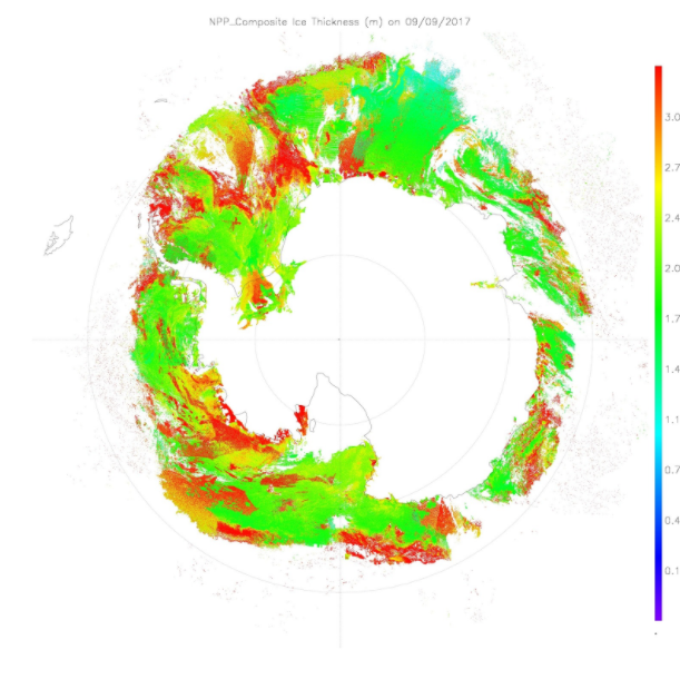 Example of VIIRS Ice Thickness (monthy composite) over Antarctica on September 9, 2017. Image courtesy of CIMSS Ice Visualization System
This dataset contains a high quality operational Environmental Data Record (EDR) of Ice Thickness and Age from the Visible Infrared Imaging Radiometer Suite (VIIRS) instrument onboard the Suomi-NPP satellite and is produced by the NOAA Environmental Satellite, Data, and Information Service (NESDIS). This daily product provides estimates of sea and lake ice thickness and age for all pixels covered with ice. The current ice thickness and age design has the ability to estimate sea and lake ice thickness up to 3 meters under both clear and cloudy conditions at night. The algorithm also works during daytime though estimates are more uncertain. The product also includes quality information which provides support information on the quality of ice estimates. There are no direct VIIRS channels related to the algorithm which actually relies on other VIIRS products such as cloud mask, ice surface temperature, and ice surface albedo that would use some or all VIIRS channels for their retrievals. The VIIRS Ice Thickness and Age products distributed by the NESDIS Data Exploitation (NDE) system and obtained from the Comprehensive Large-Array Stewardship System (CLASS) are distributed in single 86-second granules in NetCDF-4 format with metadata attributes included.
- Cite as: Key, Jeffery, Helfrich, Sean, Wang, Xuanji, and NOAA JPSS Program Office, (2017): NOAA JPSS Visible Infrared Imaging Radiometer Suite (VIIRS) Ice Thickness and Age Environmental Data Records (EDRs) from NDE. [indicate subset used]. NOAA National Centers for Environmental Information. [access date].
- gov.noaa.ncdc:C01438
- gov.noaa.class:JPSS_GRAN
| Download Data |
-
NOAA CLASS FTP Server (download)
Access and download data tar files by date and product for the previous 85 days. The directory structure is as follows, date(yyyymmdd)->instrument family->product.
|
| Order Data |
|
| Distribution Formats |
|
| Ordering Instructions |
Contact NCEI for other distribution options and instructions. |
| Distributor |
NOAA National Centers for Environmental Information
ncei.info@noaa.gov
|
| Dataset Point of Contact |
DOC/NOAA/NESDIS/NCEI > National Centers for Environmental Information, NESDIS, NOAA, U.S. Department of Commerce
ncei.sat.info@noaa.gov
|
| Time Period |
2017-07-06 to Present (time interval: 24-hour) |
| Spatial Reference System |
urn:ogc:def:crs:EPSG::4326 |
| Spatial Bounding Box Coordinates |
West: -180.0
East: 180.0
South: -90.0
North: 90.0
|
| Spatial Coverage Map |
|
| General Documentation |
|
| Processing Documents |
- JPSS STAR Science Documents
- JPSS STAR Algorithm Maturity Matrix
|
| Associated Resources |
- Snow and ice products from Suomi NPP VIIRS
-
Journal article published December 2013 by Wiley (Journal of Geophysical Research Atmosphere)
Key, J., Mahoney, R., et al, (2013), Snow and Ice Products from Suomi NPP VIIRS, J. of Geo. Res. Atmo., 118(23), 12816-12830, doi:10.1002/2013JD020459.
- Sea and Freshwater Ice Concentration from VIIRS on Suomi NPP and the Future JPSS Satellites
|
| Publication Dates |
|
| Data Presentation Form |
Digital image
|
| Dataset Progress Status |
Ongoing - data is continually being updated |
| Data Update Frequency |
Continual |
| Purpose |
Ice Thickness and Age has profound socioeconomic value due to its role in water resources and its impact on transportation, fisheries, hunting, herding, and agriculture. It also plays a significant role in climate studies, and is critical for accurate weather forecasts. |
| Use Limitations |
- For a complete description of use limitations for this EDR, see the Algorithm Theoretical Basis Document (ATBD).
|
| Dataset Citation |
- Cite as: Key, Jeffery, Helfrich, Sean, Wang, Xuanji, and NOAA JPSS Program Office, (2017): NOAA JPSS Visible Infrared Imaging Radiometer Suite (VIIRS) Ice Thickness and Age Environmental Data Records (EDRs) from NDE. [indicate subset used]. NOAA National Centers for Environmental Information. [access date].
|
| Cited Authors |
- Key, Jeffery
DOC/NOAA/NESDIS/STAR > Center for Satellite Applications and Research, NESDIS, NOAA, U.S. Department of Commerce
- Helfrich, Sean
DOC/NOAA/NESDIS/OSPO > Office of Satellite and Product Operations, NESDIS, NOAA, U.S. Department of Commerce
- Wang, Xuanji
UWI-MAD/SSEC/CIMSS/POLAR > Polar Satellite Meteorology and Climatology, Cooperative Institute for Meteorological Satellite Studies, SSEC, University of Wisconsin, Madison
- NOAA JPSS Program Office
|
| Principal Investigators |
- Key, Jeffery
DOC/NOAA/NESDIS/STAR > Center for Satellite Applications and Research, NESDIS, NOAA, U.S. Department of Commerce
- Helfrich, Sean
DOC/NOAA/NESDIS/OSPO > Office of Satellite and Product Operations, NESDIS, NOAA, U.S. Department of Commerce
|
| Collaborators |
- Wang, Xuanji
UWI-MAD/SSEC/CIMSS/POLAR > Polar Satellite Meteorology and Climatology, Cooperative Institute for Meteorological Satellite Studies, SSEC, University of Wisconsin, Madison
|
| Resource Providers |
|
| Publishers |
- NOAA National Centers for Environmental Information
|
| Theme keywords |
Global Change Master Directory (GCMD) Science Keywords
- Earth Science > Climate Indicators > Cryospheric Indicators > Sea Ice Concentration
- Earth Science > Cryosphere > Sea Ice > Sea Ice Age
- Earth Science > Climate Indicators > Cryospheric Indicators > Ice Depth/Thickness
Global Climate Observing System (GCOS) Essential Climate Variables (ECVs)- Oceanic - Surface - Sea Ice
Keyword Thesaurus Title
- Nde > Nesdis Data Exploitation
- Edr > Environmental Data Record
|
| Data Center keywords |
Global Change Master Directory (GCMD) Data Center Keywords
- DOC/NOAA/NESDIS/STAR > Center for Satellite Applications and Research, NESDIS, NOAA, U.S. Department of Commerce
- DOC/NOAA/NESDIS/NCDC > National Climatic Data Center, NESDIS, NOAA, U.S. Department of Commerce
- DOC/NOAA/NESDIS/NCEI > National Centers for Environmental Information, NESDIS, NOAA, U.S. Department of Commerce
- DOC/NOAA/NESDIS/OSPO > Office of Satellite and Product Operations, NESDIS, NOAA, U.S. Department of Commerce
|
| Platform keywords |
Global Change Master Directory (GCMD) Platform Keywords
- SUOMI-NPP > Suomi National Polar-orbiting Partnership
- NOAA-20 > Joint Polar Satellite System - 1
|
| Instrument keywords |
Global Change Master Directory (GCMD) Instrument Keywords- VIIRS > Visible-Infrared Imager-Radiometer Suite
|
| Place keywords |
Global Change Master Directory (GCMD) Location Keywords- Geographic Region > Global Ocean
|
| Project keywords |
Global Change Master Directory (GCMD) Project Keywords
- NOAA OneStop Project
- JPSS > Joint Polar Satellite System
|
| Data Resolution keywords |
Global Change Master Directory (GCMD) Horizontal Data Resolution Keywords- 1 km - < 10 km or approximately .01 degree - < .09 degree
|
| Stratum keywords |
Global Change Master Directory (GCMD) Location Keywords- Vertical Location > Sea Surface
|
| Use Constraints |
- Cite as: Key, Jeffery, Helfrich, Sean, Wang, Xuanji, and NOAA JPSS Program Office, (2017): NOAA JPSS Visible Infrared Imaging Radiometer Suite (VIIRS) Ice Thickness and Age Environmental Data Records (EDRs) from NDE. [indicate subset used]. NOAA National Centers for Environmental Information. [access date].
- Use liability: NOAA and NCEI cannot provide any warranty as to the accuracy, reliability, or completeness of furnished data. Users assume responsibility to determine the usability of these data. The user is responsible for the results of any application of this data for other than its intended purpose.
|
| Access Constraints |
- Distribution liability: NOAA and NCEI make no warranty, expressed or implied, regarding these data, nor does the fact of distribution constitute such a warranty. NOAA and NCEI cannot assume liability for any damages caused by any errors or omissions in these data. If appropriate, NCEI can only certify that the data it distributes are an authentic copy of the records that were accepted for inclusion in the NCEI archives.
|
| Fees |
- In most cases, electronic downloads of the data are free. However, fees may apply for custom orders, data certifications, copies of analog materials, and data distribution on physical media.
|
| Lineage information for: dataset |
|---|
| Lineage Statement |
The data were produced by the NOAA Office of Satellite and Product Operations (OSPO) NDE/PDA and are archived at the NOAA National Centers for Environmental Information (NCEI). |
| Processor |
- DOC/NOAA/NESDIS/STAR > Center for Satellite Applications and Research, NESDIS, NOAA, U.S. Department of Commerce
|
| Processing Steps |
- For a complete description of the processing steps, see the Algorithm Theoretical Basis Document and Data Flow Diagram.
- 2013-04-05T00:00:00 - The S-NPP Ice Thickness and Age algorithm reached beta maturity.
- 2015-12-15T00:00:00 - The S-NPP Ice Thickness and Age algorithm reached provisional maturity.
- The S-NPP Ice Thickness and Age algorithm reached validated maturity.
- 2018-06-18T00:00:00 - The NOAA-20 Ice Thickness and Age algorithm reached beta maturity.
- The NOAA-20 Ice Thickness and Age algorithm reached provisional maturity.
- 2019-05-16T00:00:00 - The NOAA-20 Ice Thickness and Age algorithm reached validated maturity.
|
| Processing Documents |
- JPSS STAR Science Documents
- JPSS STAR Algorithm Maturity Matrix
|
| Source Datasets |
- NOAA JPSS Visible Infrared Imaging Radiometer Suite (VIIRS) Sensor Data Record (SDR) from IDPS
-
NCEI landing page for JPSS-VIIRS-SDR
Source dataset landing page with general information and access links for the dataset.
- Description of Source: Sensor Data Record (SDR)
- Temporal extent used: 2012-02-07 to Present
- Spatial extent used: N:90 S:-90 E:180 W:-180
|
| Lineage information for: repository |
|---|
| Processing Steps |
- 2015-04-22T00:00:00 - NOAA created the National Centers for Environmental Information (NCEI) by merging NOAA's National Climatic Data Center (NCDC), National Geophysical Data Center (NGDC), and National Oceanographic Data Center (NODC), including the National Coastal Data Development Center (NCDDC), per the Consolidated and Further Continuing Appropriations Act, 2015, Public Law 113-235. NCEI launched publicly on April 22, 2015.
|
Last Modified: 2023-06-23
For questions about the information on this page, please email:
ncei.info@noaa.gov