NOAA JPSS Visible Infrared Imaging Radiometer Suite (VIIRS) Cloud Height (Top and Base) Environmental Data Record (EDR) from NDE
- referenceSystemInfo
- identificationInfo
- contentInfo
- distributionInfo
- dataQualityInfo
- dataQualityInfo
- dataQualityInfo
- metadataMaintenance
(MI_Metadata)
fileIdentifier: gov.noaa.ncdc:C01440
language: eng; USA
characterSet: (MD_CharacterSetCode) utf8
hierarchyLevel: (MD_ScopeCode) dataset
contact: (CI_ResponsibleParty)
organisationName: NOAA National Centers for Environmental Information
contactInfo: (CI_Contact)
address: (CI_Address)
electronicMailAddress: ncei.info@noaa.gov
onlineResource: (CI_OnlineResource)
linkage: https://www.ncei.noaa.gov/contact
name: NCEI Contact Information
description: Information for contacts at NCEI.
function: (CI_OnLineFunctionCode) information
role: (CI_RoleCode) pointOfContact
dateStamp: 2023-06-23
metadataStandardName: ISO 19115-2 Geographic Information - Metadata - Part 2: Extensions for Imagery and Gridded Data
metadataStandardVersion: ISO 19115-2:2009(E)
return to top
referenceSystemInfo: (MD_ReferenceSystem)
referenceSystemIdentifier: (RS_Identifier)
authority: (CI_Citation)
title: EPSG Geodetic Parameter Dataset Registry
date: (CI_Date)
date: 2008-11-12
dateType: (CI_DateTypeCode) publication
citedResponsibleParty: (CI_ResponsibleParty)
organisationName: International Association of Oil and Gas Producers (OGP) Geomatics Committee
contactInfo: (CI_Contact)
onlineResource: (CI_OnlineResource)
linkage: http://www.epsg-registry.org/
applicationProfile: Data Search Application
name: EPSG Geodetic Parameter Dataset Registry Application
description: Interface to the EPSG Geodetic Parameter Dataset Registry
function: (CI_OnLineFunctionCode) search
role: (CI_RoleCode) custodian
citedResponsibleParty: (CI_ResponsibleParty)
organisationName: International Association of Oil and Gas Producers (OGP) Geomatics Committee
contactInfo: (CI_Contact)
onlineResource: (CI_OnlineResource)
linkage: http://www.epsg-registry.org/export.htm?gml=urn:ogc:def:crs:EPSG::4326
applicationProfile: Download
name: Coordinate Reference System data in GML
description: Coordinate Reference System data in GML
function: (CI_OnLineFunctionCode) download
role: (CI_RoleCode) custodian
code: urn:ogc:def:crs:EPSG::4326
version: (unknown)
return to top
identificationInfo: (MD_DataIdentification)
citation: (CI_Citation)
title: NOAA JPSS Visible Infrared Imaging Radiometer Suite (VIIRS) Cloud Height (Top and Base) Environmental Data Record (EDR) from NDE
alternateTitle: JPSS-CHTB-NDE
date: (CI_Date)
date: 2017-07-06
dateType: (CI_DateTypeCode) publication
edition: Validated
identifier: (MD_Identifier)
code:
Anchor: DOI doi:10.7289/V5G73BX7
identifier: (MD_Identifier)
code: gov.noaa.ncdc:C01440
identifier: (MD_Identifier)
code: gov.noaa.class:JPSS_GRAN
citedResponsibleParty: (CI_ResponsibleParty)
organisationName: NOAA National Centers for Environmental Information
role: (CI_RoleCode) publisher
citedResponsibleParty: (CI_ResponsibleParty)
individualName: Heidinger, Andrew
organisationName: DOC/NOAA/NESDIS/STAR > Center for Satellite Applications and Research, NESDIS, NOAA, U.S. Department of Commerce
role: (CI_RoleCode) principalInvestigator
citedResponsibleParty: (CI_ResponsibleParty)
individualName: Heidinger, Andrew
organisationName: DOC/NOAA/NESDIS/STAR > Center for Satellite Applications and Research, NESDIS, NOAA, U.S. Department of Commerce
role: (CI_RoleCode) author
citedResponsibleParty: (CI_ResponsibleParty)
individualName: Donahue, David
organisationName: DOC/NOAA/NESDIS/OSPO > Office of Satellite and Product Operations, NESDIS, NOAA, U.S. Department of Commerce
role: (CI_RoleCode) principalInvestigator
citedResponsibleParty: (CI_ResponsibleParty)
individualName: Donahue, David
organisationName: DOC/NOAA/NESDIS/OSPO > Office of Satellite and Product Operations, NESDIS, NOAA, U.S. Department of Commerce
role: (CI_RoleCode) author
citedResponsibleParty: (CI_ResponsibleParty)
organisationName: NOAA JPSS Program Office
role: (CI_RoleCode) resourceProvider
citedResponsibleParty: (CI_ResponsibleParty)
organisationName: NOAA JPSS Program Office
role: (CI_RoleCode) author
presentationForm: (CI_PresentationFormCode) imageDigital
abstract: This dataset contains a high quality operational Environmental Data Record (EDR) of cloud height (top and base) from the Visible Infrared Imaging Radiometer Suite (VIIRS) instrument onboard the Suomi-NPP satellite and is produced by the NOAA Satellite and Information Service (NESDIS). The cloud height product contains an image with pixel values identifying the geopotential height at the top of a cloud layer. Additionally, this product includes data quality information that provides an assessment of the cloud height values for on-earth pixels. The algorithm uses VIIRS infrared bands M14 (8.5µm), M15 (11.2µm), and M16 (12.3µm). The spatial resolution of the EDR is 750 meters and data are collected during day and night passes which provides global coverage at a temporal resolution of approximately every 12 hours. VIIRS cloud height data distributed by the NESDIS Data Exploitation (NDE) system and obtained from the Comprehensive Large Array-Data Stewardship System (CLASS) are distributed in single 86-second granules in NetCDF-4 format with metadata attributes included.
purpose: This data set provides a high quality Environmental Data Record (EDR) of Cloud Base Heights (CBH). As a high quality EDR, this data set could be used by the general aviation community for cloud ceiling and visibility determinations or as an environmental variable in climate models.
status: (MD_ProgressCode) onGoing
pointOfContact: (CI_ResponsibleParty)
organisationName: NOAA National Centers for Environmental Information
positionName: Customer Engagement Branch
contactInfo: (CI_Contact)
phone: (CI_Telephone)
voice: 1-828-271-4800
facsimile: 1-828-271-4876
address: (CI_Address)
deliveryPoint: 151 Patton Avenue
deliveryPoint: Veach-Baley Federal Building, Room 468
city: Asheville
administrativeArea: NC
postalCode: 28801-5001
country: USA
electronicMailAddress: ncei.orders@noaa.gov
onlineResource: (CI_OnlineResource)
linkage: https://www.ncei.noaa.gov
protocol: HTTPS
applicationProfile: Web Browser
name: NOAA National Centers for Environmental Information (NCEI)
description: NCEI home page with information, data access and contact information.
function: (CI_OnLineFunctionCode) information
hoursOfService: 8:00 - 6:00 Eastern
role: (CI_RoleCode) pointOfContact
resourceMaintenance: (MD_MaintenanceInformation)
maintenanceAndUpdateFrequency: (MD_MaintenanceFrequencyCode) continual
graphicOverview: (MD_BrowseGraphic)
fileName: https://www.ncei.noaa.gov/pub/data/metadata/images/C01440.PNG
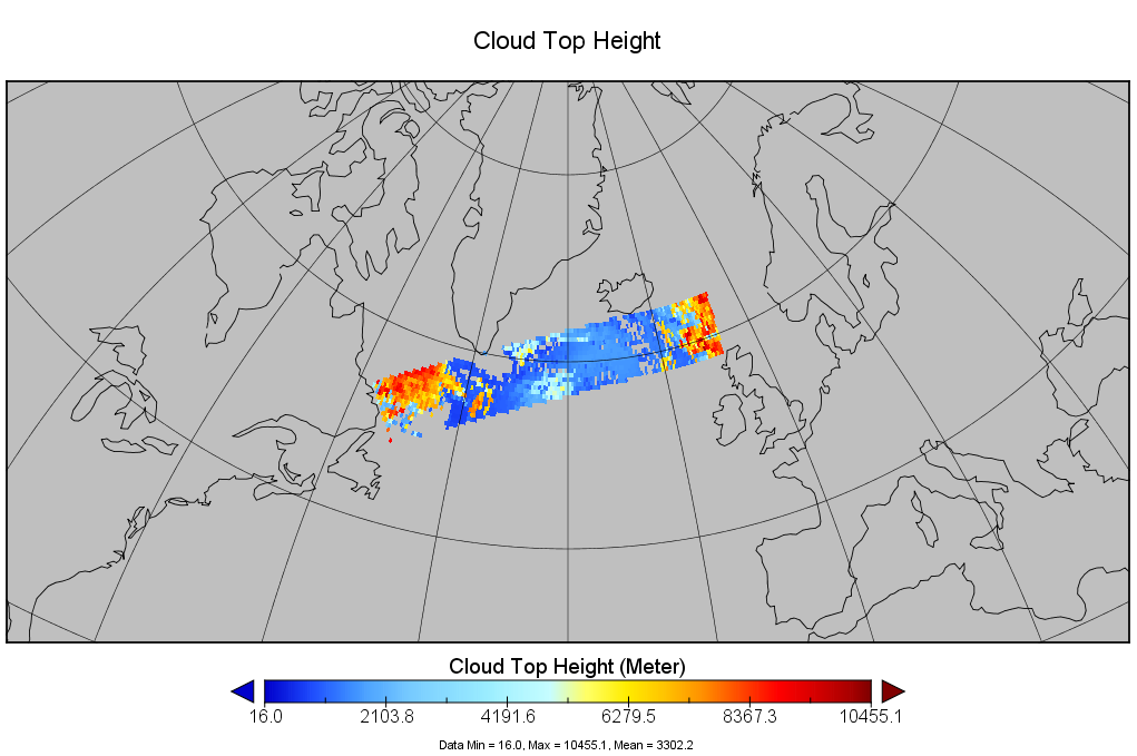
fileDescription: Suomi NPP VIIRS NDE Cloud Top Height retrieval over the northern Atlantic Ocean on July 6, 2017.
fileType: PNG
descriptiveKeywords: (MD_Keywords)
keyword: Earth Science > Atmosphere > Clouds > Cloud Properties > Cloud Top Height
keyword: Earth Science > Atmosphere > Clouds > Cloud Properties > Cloud Base Height
type: (MD_KeywordTypeCode) theme
thesaurusName: (CI_Citation)
title: Global Change Master Directory (GCMD) Science Keywords
date: (CI_Date)
date: 2018
dateType: (CI_DateTypeCode) revision
edition: Version 8.6
citedResponsibleParty: (CI_ResponsibleParty)
organisationName: Global Change Data Center, Science and Exploration Directorate, Goddard Space Flight Center (GSFC) National Aeronautics and Space Administration (NASA)
contactInfo: (CI_Contact)
onlineResource: (CI_OnlineResource)
linkage: https://earthdata.nasa.gov/about/gcmd/global-change-master-directory-gcmd-keywords
protocol: HTTPS
applicationProfile: Web Browser
name: Global Change Master Directory (GCMD) Keywords
description: The information provided on this page seeks to define how the GCMD Keywords are structured, used and accessed. It also provides information on how users can participate in the further development of the keywords.
function: (CI_OnLineFunctionCode) information
role: (CI_RoleCode) publisher
descriptiveKeywords: (MD_Keywords)
keyword: Atmospheric - Upper-air - Cloud Properties
type: (MD_KeywordTypeCode) theme
thesaurusName: (CI_Citation)
title: Global Climate Observing System (GCOS) Essential Climate Variables (ECVs)
date: (CI_Date)
date: 2017
dateType: (CI_DateTypeCode) publication
edition: Release 2017
citedResponsibleParty: (CI_ResponsibleParty)
organisationName: World Meteorological Organization, United Nations
contactInfo: (CI_Contact)
onlineResource: (CI_OnlineResource)
linkage: https://public.wmo.int/en/programmes/global-climate-observing-system/essential-climate-variables
protocol: HTTP
applicationProfile: Information
name: GCOS Essential Climate Variables
description: Overview of the GCOS Essential Climate Variables.
function: (CI_OnLineFunctionCode) information
role: (CI_RoleCode) custodian
descriptiveKeywords: (MD_Keywords)
keyword: Geographic Region > Global
type: (MD_KeywordTypeCode) place
thesaurusName: (CI_Citation)
title: Global Change Master Directory (GCMD) Location Keywords
date: (CI_Date)
date: 2018
dateType: (CI_DateTypeCode) revision
edition: Version 8.6
citedResponsibleParty: (CI_ResponsibleParty)
organisationName: Global Change Data Center, Science and Exploration Directorate, Goddard Space Flight Center (GSFC) National Aeronautics and Space Administration (NASA)
contactInfo: (CI_Contact)
onlineResource: (CI_OnlineResource)
linkage: https://earthdata.nasa.gov/about/gcmd/global-change-master-directory-gcmd-keywords
protocol: HTTPS
applicationProfile: Web Browser
name: Global Change Master Directory (GCMD) Keywords
description: The information provided on this page seeks to define how the GCMD Keywords are structured, used and accessed. It also provides information on how users can participate in the further development of the keywords.
function: (CI_OnLineFunctionCode) information
role: (CI_RoleCode) publisher
descriptiveKeywords: (MD_Keywords)
keyword: Vertical Location > Troposphere
type: (MD_KeywordTypeCode) stratum
thesaurusName: (CI_Citation)
title: Global Change Master Directory (GCMD) Location Keywords
date: (CI_Date)
date: 2018
dateType: (CI_DateTypeCode) revision
edition: Version 8.6
citedResponsibleParty: (CI_ResponsibleParty)
organisationName: Global Change Data Center, Science and Exploration Directorate, Goddard Space Flight Center (GSFC) National Aeronautics and Space Administration (NASA)
contactInfo: (CI_Contact)
onlineResource: (CI_OnlineResource)
linkage: https://earthdata.nasa.gov/about/gcmd/global-change-master-directory-gcmd-keywords
protocol: HTTPS
applicationProfile: Web Browser
name: Global Change Master Directory (GCMD) Keywords
description: The information provided on this page seeks to define how the GCMD Keywords are structured, used and accessed. It also provides information on how users can participate in the further development of the keywords.
function: (CI_OnLineFunctionCode) information
role: (CI_RoleCode) publisher
descriptiveKeywords: (MD_Keywords)
keyword: NOAA OneStop Project
keyword: JPSS > Joint Polar Satellite System
keyword: NDE > NESDIS Data Exploitation
type: (MD_KeywordTypeCode) project
thesaurusName: (CI_Citation)
title: Global Change Master Directory (GCMD) Project Keywords
date: (CI_Date)
date: 2018
dateType: (CI_DateTypeCode) revision
edition: Version 8.6
citedResponsibleParty: (CI_ResponsibleParty)
organisationName: Global Change Data Center, Science and Exploration Directorate, Goddard Space Flight Center (GSFC) National Aeronautics and Space Administration (NASA)
contactInfo: (CI_Contact)
onlineResource: (CI_OnlineResource)
linkage: https://earthdata.nasa.gov/about/gcmd/global-change-master-directory-gcmd-keywords
protocol: HTTPS
applicationProfile: Web Browser
name: Global Change Master Directory (GCMD) Keywords
description: The information provided on this page seeks to define how the GCMD Keywords are structured, used and accessed. It also provides information on how users can participate in the further development of the keywords.
function: (CI_OnLineFunctionCode) information
role: (CI_RoleCode) publisher
descriptiveKeywords: (MD_Keywords)
keyword: VIIRS > Visible-Infrared Imager-Radiometer Suite
type: (MD_KeywordTypeCode) instrument
thesaurusName: (CI_Citation)
title: Global Change Master Directory (GCMD) Instrument Keywords
date: (CI_Date)
date: 2018
dateType: (CI_DateTypeCode) revision
edition: Version 8.6
citedResponsibleParty: (CI_ResponsibleParty)
organisationName: Global Change Data Center, Science and Exploration Directorate, Goddard Space Flight Center (GSFC) National Aeronautics and Space Administration (NASA)
contactInfo: (CI_Contact)
onlineResource: (CI_OnlineResource)
linkage: https://earthdata.nasa.gov/about/gcmd/global-change-master-directory-gcmd-keywords
protocol: HTTPS
applicationProfile: Web Browser
name: Global Change Master Directory (GCMD) Keywords
description: The information provided on this page seeks to define how the GCMD Keywords are structured, used and accessed. It also provides information on how users can participate in the further development of the keywords.
function: (CI_OnLineFunctionCode) information
role: (CI_RoleCode) publisher
descriptiveKeywords: (MD_Keywords)
keyword: SUOMI-NPP > Suomi National Polar-orbiting Partnership
keyword: NOAA-20 > Joint Polar Satellite System - 1
type: (MD_KeywordTypeCode) platform
thesaurusName: (CI_Citation)
title: Global Change Master Directory (GCMD) Platform Keywords
date: (CI_Date)
date: 2018
dateType: (CI_DateTypeCode) revision
edition: Version 8.6
citedResponsibleParty: (CI_ResponsibleParty)
organisationName: Global Change Data Center, Science and Exploration Directorate, Goddard Space Flight Center (GSFC) National Aeronautics and Space Administration (NASA)
contactInfo: (CI_Contact)
onlineResource: (CI_OnlineResource)
linkage: https://earthdata.nasa.gov/about/gcmd/global-change-master-directory-gcmd-keywords
protocol: HTTPS
applicationProfile: Web Browser
name: Global Change Master Directory (GCMD) Keywords
description: The information provided on this page seeks to define how the GCMD Keywords are structured, used and accessed. It also provides information on how users can participate in the further development of the keywords.
function: (CI_OnLineFunctionCode) information
role: (CI_RoleCode) publisher
descriptiveKeywords: (MD_Keywords)
keyword: 500 meters - < 1 km
type: (MD_KeywordTypeCode) dataResolution
thesaurusName: (CI_Citation)
title: Global Change Master Directory (GCMD) Horizontal Data Resolution Keywords
date: (CI_Date)
date: 2018
dateType: (CI_DateTypeCode) revision
edition: Version 8.6
citedResponsibleParty: (CI_ResponsibleParty)
organisationName: Global Change Data Center, Science and Exploration Directorate, Goddard Space Flight Center (GSFC) National Aeronautics and Space Administration (NASA)
contactInfo: (CI_Contact)
onlineResource: (CI_OnlineResource)
linkage: https://earthdata.nasa.gov/about/gcmd/global-change-master-directory-gcmd-keywords
protocol: HTTPS
applicationProfile: Web Browser
name: Global Change Master Directory (GCMD) Keywords
description: The information provided on this page seeks to define how the GCMD Keywords are structured, used and accessed. It also provides information on how users can participate in the further development of the keywords.
function: (CI_OnLineFunctionCode) information
role: (CI_RoleCode) publisher
descriptiveKeywords: (MD_Keywords)
keyword: DOC/NOAA/NESDIS/STAR > Center for Satellite Applications and Research, NESDIS, NOAA, U.S. Department of Commerce
keyword: DOC/NOAA/NESDIS/NCDC > National Climatic Data Center, NESDIS, NOAA, U.S. Department of Commerce
keyword: DOC/NOAA/NESDIS/NCEI > National Centers for Environmental Information, NESDIS, NOAA, U.S. Department of Commerce
keyword: DOC/NOAA/NESDIS/OSPO > Office of Satellite and Product Operations, NESDIS, NOAA, U.S. Department of Commerce
type: (MD_KeywordTypeCode) dataCentre
thesaurusName: (CI_Citation)
title: Global Change Master Directory (GCMD) Data Center Keywords
date: (CI_Date)
date: 2018
dateType: (CI_DateTypeCode) revision
edition: Version 8.6
citedResponsibleParty: (CI_ResponsibleParty)
organisationName: Global Change Data Center, Science and Exploration Directorate, Goddard Space Flight Center (GSFC) National Aeronautics and Space Administration (NASA)
contactInfo: (CI_Contact)
onlineResource: (CI_OnlineResource)
linkage: https://earthdata.nasa.gov/about/gcmd/global-change-master-directory-gcmd-keywords
protocol: HTTPS
applicationProfile: Web Browser
name: Global Change Master Directory (GCMD) Keywords
description: The information provided on this page seeks to define how the GCMD Keywords are structured, used and accessed. It also provides information on how users can participate in the further development of the keywords.
function: (CI_OnLineFunctionCode) information
role: (CI_RoleCode) publisher
descriptiveKeywords: (MD_Keywords)
keyword: gov.noaa.class:JPSS_GRAN
type: (MD_KeywordTypeCode) other
resourceConstraints: (MD_Constraints)
useLimitation: For a complete list of limitations of this dataset see the Algorithm Theoretical Basis Document (ATBD).
resourceConstraints: (MD_LegalConstraints)
useConstraints: (MD_RestrictionCode) otherRestrictions
otherConstraints: Cite as: Heidinger, Andrew, Donahue, David, and NOAA JPSS Program Office (2017): NOAA JPSS Visible Infrared Imaging Radiometer Suite (VIIRS) Cloud Height (Top and Base) Environmental Data Record (EDR) from NDE. [indicate subset used]. NOAA National Centers for Environmental Information. doi:10.7289/V5G73BX7. [access date].
resourceConstraints: (MD_LegalConstraints)
accessConstraints: (MD_RestrictionCode) otherRestrictions
otherConstraints: Distribution liability: NOAA and NCEI make no warranty, expressed or implied, regarding these data, nor does the fact of distribution constitute such a warranty. NOAA and NCEI cannot assume liability for any damages caused by any errors or omissions in these data. If appropriate, NCEI can only certify that the data it distributes are an authentic copy of the records that were accepted for inclusion in the NCEI archives.
resourceConstraints: (MD_LegalConstraints)
useConstraints: (MD_RestrictionCode) otherRestrictions
otherConstraints: Use liability: NOAA and NCEI cannot provide any warranty as to the accuracy, reliability, or completeness of furnished data. Users assume responsibility to determine the usability of these data. The user is responsible for the results of any application of this data for other than its intended purpose.
aggregationInfo: (MD_AggregateInformation)
aggregateDataSetName: (CI_Citation)
title: Using CALIPSO to explore the sensitivity to cirrus height in the infrared observations from NPOESS/VIIRS and GOES-R/ABI.
date: (missing)
identifier: (MD_Identifier)
code: doi:10.1029/2009JD012152
citedResponsibleParty: (CI_ResponsibleParty)
organisationName: Wiley
role: (CI_RoleCode) publisher
citedResponsibleParty: (CI_ResponsibleParty)
organisationName: (missing)
contactInfo: (CI_Contact)
onlineResource: (CI_OnlineResource)
linkage: https://doi.org/10.1029/2009JD012152
protocol: HTTPS
applicationProfile: Web Browser
name: Journal article published February 2010 by Wiley (Journal of Geophysical Research Atmospheres)
description: Heidinger, A., Pavolonis, M., et al, (2010), Using CALIPSO to explore the sensitivity to cirrus height in the infrared observations from NPOESS/VIIRS and GOES-R/ABI, J. Geo. Res., 115(D4), doi:10.1029/2009JD012152.
function: (CI_OnLineFunctionCode) information
role: (missing)
associationType: (DS_AssociationTypeCode) crossReference
initiativeType: (DS_InitiativeTypeCode) sciencePaper
spatialRepresentationType: (MD_SpatialRepresentationTypeCode) grid
spatialResolution: (MD_Resolution)
distance:
Distance: 750
language: eng; USA
topicCategory: (MD_TopicCategoryCode) climatologyMeteorologyAtmosphere
extent: (EX_Extent)
geographicElement: (EX_GeographicBoundingBox)
extentTypeCode: 1
westBoundLongitude: -180.0
eastBoundLongitude: 180.0
southBoundLatitude: -90.0
northBoundLatitude: 90.0
temporalElement: (EX_TemporalExtent)
extent:
TimePeriod:
description: ground condition
beginPosition: 2017-07-06
endPosition:
timeInterval: 12
return to top
contentInfo: (MI_CoverageDescription)
attributeDescription:
RecordType: JRR-CloudHeight_v1r1_npp_sYYYYMMDDHHMMSSS_eYYYYMMDDHHMMSSS_cYYYYMMDDHHMMSSS.nc
contentType: (MD_CoverageContentTypeCode) physicalMeasurement
dimension: (MD_Band)
sequenceIdentifier:
MemberName:
aName: Latitude
attributeType:
TypeName:
aName: float
descriptor: Latitude
units: http://example.org/someUnitsDictionary.xml#degrees_north
dimension: (MD_Band)
sequenceIdentifier:
MemberName:
aName: Longitude
attributeType:
TypeName:
aName: float
descriptor: Longitude
units: http://example.org/someUnitsDictionary.xml#degrees_east
dimension: (MD_Band)
sequenceIdentifier:
MemberName:
aName: StartRow
attributeType:
TypeName:
aName: int
descriptor: Start row index
dimension: (MD_Band)
sequenceIdentifier:
MemberName:
aName: StartColumn
attributeType:
TypeName:
aName: int
descriptor: Start column index
dimension: (MD_Band)
sequenceIdentifier:
MemberName:
aName: CldTopTemp
attributeType:
TypeName:
aName: float
descriptor: Cloud Top Temperature
units: http://example.org/someUnitsDictionary.xml#Kelvin
dimension: (MD_Band)
sequenceIdentifier:
MemberName:
aName: CldTopPres
attributeType:
TypeName:
aName: float
descriptor: Cloud Top Presssure
units: http://example.org/someUnitsDictionary.xml#hPa
dimension: (MD_Band)
sequenceIdentifier:
MemberName:
aName: CldTopHght
attributeType:
TypeName:
aName: float
descriptor: Cloud Top Height
units: http://example.org/someUnitsDictionary.xml#Meter
dimension: (MD_Band)
sequenceIdentifier:
MemberName:
aName: CldHgtFlag
attributeType:
TypeName:
aName: byte
descriptor: Cloud Height Processing Flag
units: http://example.org/someUnitsDictionary.xml#1
dimension: (MD_Band)
sequenceIdentifier:
MemberName:
aName: CldPackedFlag
attributeType:
TypeName:
aName: byte
descriptor: Cloud Height Diagnostic Flag
units: http://example.org/someUnitsDictionary.xml#1
dimension: (MD_Band)
sequenceIdentifier:
MemberName:
aName: CldTopEmss
attributeType:
TypeName:
aName: float
descriptor: Cloud Top Emissivity
units: http://example.org/someUnitsDictionary.xml#1
dimension: (MD_Band)
sequenceIdentifier:
MemberName:
aName: CloudHgtQF
attributeType:
TypeName:
aName: byte
descriptor: Cloud Height Quality Flag
units: http://example.org/someUnitsDictionary.xml#1
dimension: (MD_Band)
sequenceIdentifier:
MemberName:
aName: CloudLayer
attributeType:
TypeName:
aName: byte
descriptor: Cloud Layer
units: http://example.org/someUnitsDictionary.xml#1
dimension: (MD_Band)
sequenceIdentifier:
MemberName:
aName: InverFlag
attributeType:
TypeName:
aName: byte
descriptor: Inversion Flag
units: http://example.org/someUnitsDictionary.xml#1
dimension: (MD_Band)
sequenceIdentifier:
MemberName:
aName: TcError
attributeType:
TypeName:
aName: float
descriptor: Tc Error
units: http://example.org/someUnitsDictionary.xml#Kelvin
dimension: (MD_Band)
sequenceIdentifier:
MemberName:
aName: PcError
attributeType:
TypeName:
aName: float
descriptor: Pc Error
units: http://example.org/someUnitsDictionary.xml#hPa
dimension: (MD_Band)
sequenceIdentifier:
MemberName:
aName: ZcError
attributeType:
TypeName:
aName: float
descriptor: Zc Error
units: http://example.org/someUnitsDictionary.xml#Meter
dimension: (MD_Band)
sequenceIdentifier:
MemberName:
aName: Cost
attributeType:
TypeName:
aName: float
descriptor: Cost
units: http://example.org/someUnitsDictionary.xml#1
dimension: (MD_Band)
sequenceIdentifier:
MemberName:
aName: Total_Cloud_Fraction
attributeType:
TypeName:
aName: float
descriptor: Total Cloud Fraction
units: http://example.org/someUnitsDictionary.xml#1
dimension: (MD_Band)
sequenceIdentifier:
MemberName:
aName: Total_Cloud_Fraction_Uncer
attributeType:
TypeName:
aName: float
descriptor: Total Cloud Fraction Uncertainty
units: http://example.org/someUnitsDictionary.xml#1
dimension: (MD_Band)
sequenceIdentifier:
MemberName:
aName: High_Cloud_Fraction
attributeType:
TypeName:
aName: float
descriptor: High Cloud Fraction
units: http://example.org/someUnitsDictionary.xml#1
dimension: (MD_Band)
sequenceIdentifier:
MemberName:
aName: Mid_Cloud_Fraction
attributeType:
TypeName:
aName: float
descriptor: Mid Cloud Fraction
units: http://example.org/someUnitsDictionary.xml#1
dimension: (MD_Band)
sequenceIdentifier:
MemberName:
aName: Low_Cloud_Fraction
attributeType:
TypeName:
aName: float
descriptor: Low Cloud Fraction
units: http://example.org/someUnitsDictionary.xml#1
dimension: (MD_Band)
sequenceIdentifier:
MemberName:
aName: Shadow_Mask
attributeType:
TypeName:
aName: byte
descriptor: Shadow Mask
units: http://example.org/someUnitsDictionary.xml#1
dimension: (MD_Band)
sequenceIdentifier:
MemberName:
aName: SC_Cld_Prob
attributeType:
TypeName:
aName: float
descriptor: Supercooled Cld Prob
units: http://example.org/someUnitsDictionary.xml#%25
dimension: (MD_Band)
sequenceIdentifier:
MemberName:
aName: Conv_Cld_Prob
attributeType:
TypeName:
aName: float
descriptor: Convective Cld Prob
units: http://example.org/someUnitsDictionary.xml#%25
dimension: (MD_Band)
sequenceIdentifier:
MemberName:
aName: MinCldTopTemp
attributeType:
TypeName:
aName: float
descriptor: Minimum of cloud top temperature
units: http://example.org/someUnitsDictionary.xml#Kelvin
dimension: (MD_Band)
sequenceIdentifier:
MemberName:
aName: MaxCldTopTemp
attributeType:
TypeName:
aName: float
descriptor: Maximum of cloud top temperature
units: http://example.org/someUnitsDictionary.xml#Kelvin
dimension: (MD_Band)
sequenceIdentifier:
MemberName:
aName: MeanCldTopTemp
attributeType:
TypeName:
aName: float
descriptor: Mean of cloud top temperature
units: http://example.org/someUnitsDictionary.xml#Kelvin
dimension: (MD_Band)
sequenceIdentifier:
MemberName:
aName: StdDevCldTopTemp
attributeType:
TypeName:
aName: float
descriptor: Std Dev of cloud top temperature
units: http://example.org/someUnitsDictionary.xml#Kelvin
dimension: (MD_Band)
sequenceIdentifier:
MemberName:
aName: MinCldTopPres
attributeType:
TypeName:
aName: float
descriptor: Minimum of cloud top pressure
units: http://example.org/someUnitsDictionary.xml#hPa
dimension: (MD_Band)
sequenceIdentifier:
MemberName:
aName: MaxCldTopPres
attributeType:
TypeName:
aName: float
descriptor: Maximum of cloud top pressure
units: http://example.org/someUnitsDictionary.xml#hPa
dimension: (MD_Band)
sequenceIdentifier:
MemberName:
aName: MeanCldTopPres
attributeType:
TypeName:
aName: float
descriptor: Mean of cloud top pressure
units: http://example.org/someUnitsDictionary.xml#hPa
dimension: (MD_Band)
sequenceIdentifier:
MemberName:
aName: StdDevCldTopPres
attributeType:
TypeName:
aName: float
descriptor: Std Dev of cloud top pressure
units: http://example.org/someUnitsDictionary.xml#hPa
dimension: (MD_Band)
sequenceIdentifier:
MemberName:
aName: MinCldTopHeight
attributeType:
TypeName:
aName: float
descriptor: Minimum of cloud top Height
units: http://example.org/someUnitsDictionary.xml#Meter
dimension: (MD_Band)
sequenceIdentifier:
MemberName:
aName: MaxCldTopHeight
attributeType:
TypeName:
aName: float
descriptor: Maximum of cloud top Height
units: http://example.org/someUnitsDictionary.xml#Meter
dimension: (MD_Band)
sequenceIdentifier:
MemberName:
aName: MeanCldTopHeight
attributeType:
TypeName:
aName: float
descriptor: Mean of cloud top Height
units: http://example.org/someUnitsDictionary.xml#Meter
dimension: (MD_Band)
sequenceIdentifier:
MemberName:
aName: StdDevCldTopHeight
attributeType:
TypeName:
aName: float
descriptor: Std Dev of cloud top Height
units: http://example.org/someUnitsDictionary.xml#Meter
dimension: (MD_Band)
sequenceIdentifier:
MemberName:
aName: NumOfQualityFlag
attributeType:
TypeName:
aName: int
descriptor: Number of quality flag
units: http://example.org/someUnitsDictionary.xml#1
dimension: (MD_Band)
sequenceIdentifier:
MemberName:
aName: TotalCloudPixel
attributeType:
TypeName:
aName: int
descriptor: Total Number of detected cloud pixels
units: http://example.org/someUnitsDictionary.xml#1
dimension: (MD_Band)
sequenceIdentifier:
MemberName:
aName: TerminatorPixPct
attributeType:
TypeName:
aName: float
descriptor: Percent of terminator pixels
units: http://example.org/someUnitsDictionary.xml#%25
dimension: (MD_Band)
sequenceIdentifier:
MemberName:
aName: ValidRetrPct
attributeType:
TypeName:
aName: float
descriptor: Valid, good converged retrieval
units: http://example.org/someUnitsDictionary.xml#%25
dimension: (MD_Band)
sequenceIdentifier:
MemberName:
aName: InvalidRetrSpaceViewPct
attributeType:
TypeName:
aName: float
descriptor: Invalid pixel due to space view
units: http://example.org/someUnitsDictionary.xml#%25
dimension: (MD_Band)
sequenceIdentifier:
MemberName:
aName: InvalidRetrSatZenPct
attributeType:
TypeName:
aName: float
descriptor: Invalid pixel due to being outside of sensor zenith range
units: http://example.org/someUnitsDictionary.xml#%25
dimension: (MD_Band)
sequenceIdentifier:
MemberName:
aName: InvalidRetrBadDataPct
attributeType:
TypeName:
aName: float
descriptor: Invalid earth pixel due to bad data: bad or missing 11 um BT or bad missing clear sky 11 um BT
units: http://example.org/someUnitsDictionary.xml#%25
dimension: (MD_Band)
sequenceIdentifier:
MemberName:
aName: InvalidRetrCldMaskPct
attributeType:
TypeName:
aName: float
descriptor: Invalid due to cloud mask being clear or probably clear
units: http://example.org/someUnitsDictionary.xml#%25
dimension: (MD_Band)
sequenceIdentifier:
MemberName:
aName: InvalidRetrMissCldTypePct
attributeType:
TypeName:
aName: float
descriptor: Invalid due to missing cloud type
units: http://example.org/someUnitsDictionary.xml#%25
dimension: (MD_Band)
sequenceIdentifier:
MemberName:
aName: InvalidRetrFailedPct
attributeType:
TypeName:
aName: float
descriptor: Failed Retrieval
units: http://example.org/someUnitsDictionary.xml#%25
dimension: (MD_Band)
sequenceIdentifier:
MemberName:
aName: DayTimePixPct
attributeType:
TypeName:
aName: float
descriptor: Percent of daytime pixels
units: http://example.org/someUnitsDictionary.xml#%25
dimension: (MD_Band)
sequenceIdentifier:
MemberName:
aName: NightTimePixPct
attributeType:
TypeName:
aName: float
descriptor: Percent of nighttime pixels
units: http://example.org/someUnitsDictionary.xml#%25
dimension: (MD_Band)
sequenceIdentifier:
MemberName:
aName: ProcOrder
attributeType:
TypeName:
aName: byte
descriptor: Processing_Order
units: http://example.org/someUnitsDictionary.xml#1
dimension: (MD_Band)
sequenceIdentifier:
MemberName:
aName: ChanOn
attributeType:
TypeName:
aName: byte
descriptor: Channel On info
units: http://example.org/someUnitsDictionary.xml#1
dimension: (MD_Band)
sequenceIdentifier:
MemberName:
aName: AchaMode
attributeType:
TypeName:
aName: int
descriptor: Acha Mode
units: http://example.org/someUnitsDictionary.xml#
dimension: (MD_Band)
sequenceIdentifier:
MemberName:
aName: Latitude_Pc
attributeType:
TypeName:
aName: float
descriptor: Parallax corrected Latitude
units: http://example.org/someUnitsDictionary.xml#Degree
dimension: (MD_Band)
sequenceIdentifier:
MemberName:
aName: Longitude_Pc
attributeType:
TypeName:
aName: float
descriptor: Parallax corrected Longitude
units: http://example.org/someUnitsDictionary.xml#Degree
return to top
distributionInfo: (MD_Distribution)
distributor: (MD_Distributor)
distributorContact: (CI_ResponsibleParty)
organisationName: NOAA National Centers for Environmental Information
contactInfo: (CI_Contact)
address: (CI_Address)
electronicMailAddress: ncei.info@noaa.gov
onlineResource: (CI_OnlineResource)
linkage: https://www.ncei.noaa.gov/contact
name: NCEI Contact Information
description: Information for contacts at NCEI.
function: (CI_OnLineFunctionCode) information
role: (CI_RoleCode) distributor
distributionOrderProcess: (MD_StandardOrderProcess)
fees: In most cases, electronic downloads of the data are free. However, fees may apply for custom orders, data certifications, copies of analog materials, and data distribution on physical media.
orderingInstructions: Contact NCEI for other distribution options and instructions.
distributorFormat: (MD_Format)
name: NetCDF
version: 4
distributorTransferOptions: (MD_DigitalTransferOptions)
onLine: (CI_OnlineResource)
linkage: https://doi.org/10.7289/V5G73BX7
protocol: HTTPS
applicationProfile: Landing Page
name: NCEI Dataset Landing Page
description: Landing page for the dataset.
function: (CI_OnLineFunctionCode) information
distributorTransferOptions: (MD_DigitalTransferOptions)
onLine: (CI_OnlineResource)
linkage: ftp://ftp-jpss.avl.class.noaa.gov/
applicationProfile: Download
name: NOAA CLASS FTP Server
description: Access and download data tar files by date and product for the previous 85 days. The directory structure is as follows, date(yyyymmdd)->instrument family->product.
function: (CI_OnLineFunctionCode) download
distributorTransferOptions: (MD_DigitalTransferOptions)
onLine: (CI_OnlineResource)
linkage: http://www.class.noaa.gov/saa/products/search?datatype_family=JPSS_GRAN
protocol: HTTPS
applicationProfile: Data Search Application
name: NOAA CLASS Data Search and Order
description: Search the data archive and submit an order for the dataset via the interface.
function: (CI_OnLineFunctionCode) order
distributorTransferOptions: (MD_DigitalTransferOptions)
onLine: (CI_OnlineResource)
linkage: https://www.star.nesdis.noaa.gov/jpss/clouds.php
protocol: HTTPS
applicationProfile: Information
name: JPSS Clouds Products Team
description: STAR project landing page with documentation and contact info for the dataset.
function: (CI_OnLineFunctionCode) information
return to top
dataQualityInfo: (DQ_DataQuality)
scope: (DQ_Scope)
level: (MD_ScopeCode) dataset
extent: #boundingExtent
lineage: (LI_Lineage)
statement: The data were produced by the NOAA Office of Satellite and Product Operations (OSPO) NDE/PDA and are archived at the NOAA National Centers for Environmental Information (NCEI).
processStep: (LE_ProcessStep)
description: For a complete description of the processing steps, see the Algorithm Theoretical Basis Document and Data Flow Diagram.
dateTime: (missing)
processor: (CI_ResponsibleParty)
organisationName: DOC/NOAA/NESDIS/STAR > Center for Satellite Applications and Research, NESDIS, NOAA, U.S. Department of Commerce
role: (CI_RoleCode) processor
source: sd001
processingInformation: (LE_Processing)
identifier: (missing)
documentation: (CI_Citation)
title: JPSS STAR Science Documents
date: (missing)
citedResponsibleParty: (CI_ResponsibleParty)
organisationName: DOC/NOAA/NESDIS/STAR > Center for Satellite Applications and Research, NESDIS, NOAA, U.S. Department of Commerce
role: (CI_RoleCode) publisher
citedResponsibleParty: (CI_ResponsibleParty)
organisationName: (missing)
contactInfo: (CI_Contact)
onlineResource: (CI_OnlineResource)
linkage: https://www.star.nesdis.noaa.gov/jpss/Docs.php
protocol: HTTPS
applicationProfile: Web Browser
name: JPSS STAR Science Documents
description: Includes the Algorithm Maturity Reviews, Readmes, and User Guides.
function: (CI_OnLineFunctionCode) information
role: (missing)
processStep: (LE_ProcessStep)
description: The S-NPP Cloud Height (Top and Base) algorithm reached beta maturity.
dateTime:
DateTime: 2013-04-05T00:00:00
processor: (CI_ResponsibleParty)
organisationName: (missing)
role: (CI_RoleCode) processor
processingInformation: (LE_Processing)
identifier: (missing)
documentation: (CI_Citation)
title: JPSS STAR Algorithm Maturity Matrix
date: (missing)
citedResponsibleParty: (CI_ResponsibleParty)
organisationName: DOC/NOAA/NESDIS/STAR > Center for Satellite Applications and Research, NESDIS, NOAA, U.S. Department of Commerce
role: (CI_RoleCode) publisher
citedResponsibleParty: (CI_ResponsibleParty)
organisationName: (missing)
contactInfo: (CI_Contact)
onlineResource: (CI_OnlineResource)
linkage: https://www.star.nesdis.noaa.gov/jpss/AlgorithmMaturity.php
protocol: HTTPS
applicationProfile: Web Browser
name: JPSS STAR Algorithm Maturity Matrix
description: Table with algorithm maturity reviews by product.
function: (CI_OnLineFunctionCode) information
role: (missing)
processStep: (LE_ProcessStep)
description: The S-NPP Cloud Height (Top and Base) algorithm reached provisional maturity.
dateTime:
DateTime: 2015-12-15T00:00:00
processor: (CI_ResponsibleParty)
organisationName: (missing)
role: (CI_RoleCode) processor
processStep: (LE_ProcessStep)
description: The S-NPP Cloud Height (Top and Base) algorithm reached validated maturity.
dateTime: (missing)
processor: (CI_ResponsibleParty)
organisationName: (missing)
role: (CI_RoleCode) processor
processStep: (LE_ProcessStep)
description: The NOAA-20 Cloud Height (Top and Base) algorithm reached beta maturity.
dateTime:
DateTime: 2018-07-23T00:00:00
processor: (CI_ResponsibleParty)
organisationName: (missing)
role: (CI_RoleCode) processor
processStep: (LE_ProcessStep)
description: The NOAA-20 Cloud Height (Top and Base) algorithm reached provisional maturity.
dateTime: (missing)
processor: (CI_ResponsibleParty)
organisationName: (missing)
role: (CI_RoleCode) processor
processStep: (LE_ProcessStep)
description: The NOAA-20 Cloud Height (Top and Base) algorithm reached validated maturity.
dateTime: (missing)
processor: (CI_ResponsibleParty)
organisationName: (missing)
role: (CI_RoleCode) processor
source: (LE_Source)
description: Sensor Data Record (SDR)
sourceCitation: (CI_Citation)
title: NOAA JPSS Visible Infrared Imaging Radiometer Suite (VIIRS) Sensor Data Record (SDR) from IDPS
date: (CI_Date)
date: 2012-02-07
dateType: (CI_DateTypeCode) publication
edition: Validated
identifier: (MD_Identifier)
code: doi:10.7289/V58G8HSZ
citedResponsibleParty: (CI_ResponsibleParty)
organisationName: DOC/NOAA/NESDIS/NCEI > National Centers for Environmental Information, NESDIS, NOAA, U.S. Department of Commerce
role: (CI_RoleCode) distributor
citedResponsibleParty: (CI_ResponsibleParty)
organisationName: (missing)
contactInfo: (CI_Contact)
onlineResource: (CI_OnlineResource)
linkage: https://doi.org/10.7289/V58G8HSZ
protocol: HTTPS
applicationProfile: Web Browser
name: NCEI landing page for JPSS-VIIRS-SDR
description: Source dataset landing page with general information and access links for the dataset.
function: (CI_OnLineFunctionCode) information
role: (missing)
sourceExtent: (EX_Extent)
geographicElement: (EX_GeographicBoundingBox)
extentTypeCode: 1
westBoundLongitude: -180
eastBoundLongitude: 180
southBoundLatitude: -90
northBoundLatitude: 90
temporalElement: (EX_TemporalExtent)
extent:
TimePeriod:
beginPosition: 2012-02-07
endPosition:
sourceStep: ps001
return to top
dataQualityInfo: (DQ_DataQuality)
scope: (DQ_Scope)
level: (MD_ScopeCode) repository
levelDescription: (MD_ScopeDescription)
other: NOAA National Centers for Environmental Information
lineage: (LI_Lineage)
processStep: (LE_ProcessStep)
description: NOAA created the National Centers for Environmental Information (NCEI) by merging NOAA's National Climatic Data Center (NCDC), National Geophysical Data Center (NGDC), and National Oceanographic Data Center (NODC), including the National Coastal Data Development Center (NCDDC), per the Consolidated and Further Continuing Appropriations Act, 2015, Public Law 113-235. NCEI launched publicly on April 22, 2015.
dateTime:
DateTime: 2015-04-22T00:00:00
return to top
dataQualityInfo: (DQ_DataQuality)
scope: (DQ_Scope)
level: (MD_ScopeCode) series
levelDescription: (MD_ScopeDescription)
other: Data Stewardship
report: (DQ_ConceptualConsistency)
nameOfMeasure: Data Stewardship Maturity Assessment
measureIdentification: (MD_Identifier)
code: MM-Stew
measureDescription: The Data Stewardship Maturity Matrix (DSMM) is a unified framework that defines criteria for each of nine components based on measurable practices, which can be used to apply a progressive, 6-level rating to an individual dataset, representing stewardship maturity stages rated as Not Assessed or Not Available (Level 0), adHoc (Level 1), minimum (Level 2), intermediate (Level 3), advanced (Level 4), and optimal (Level 5).
evaluationMethodDescription: Data Stewardship Maturity Assessment was evaluated by the metadata content editor for the NOAA OneStop project using the Scientific Data Stewardship Maturity Assessment Model Template v4.0.
evaluationProcedure: (CI_Citation)
title: The Scientific Data Stewardship Maturity Assessment Model Template
date: (CI_Date)
date: 2015-06-23
dateType: (CI_DateTypeCode) publication
edition: NCDC-CICS-SMM_0001_Rev.1 v4.0 06/23/2015
identifier: (MD_Identifier)
code:
Anchor: DOI link doi:10.10.6084/m9.figshare.1211954
citedResponsibleParty: (CI_ResponsibleParty)
individualName: Peng, Ge
organisationName: CICS-NC/NCEI
role: (CI_RoleCode) author
citedResponsibleParty: (CI_ResponsibleParty)
organisationName: (inapplicable)
contactInfo: (CI_Contact)
onlineResource: (CI_OnlineResource)
linkage: https://doi.org/10.6084/m9.figshare.1211954
protocol: HTTPS
applicationProfile: Web Browser
name: The Scientific Data Stewardship Maturity Assessment Model Template
description: Landing page for quality evaluation procedure.
function: (CI_OnLineFunctionCode) information
role: (inapplicable)
presentationForm: (CI_PresentationFormCode) documentDigital
dateTime:
DateTime: 2017-09-08T00:00:00
result: (DQ_QuantitativeResult)
valueUnit: (inapplicable)
value:
Record:
CodeListValue: advanced
value:
Record:
CodeListValue: optimal
value:
Record:
CodeListValue: advanced
value:
Record:
CodeListValue: optimal
value:
Record:
CodeListValue: optimal
value:
Record:
CodeListValue: advanced
value:
Record:
CodeListValue: intermediate
value:
Record:
CodeListValue: intermediate
value:
Record:
CodeListValue: optimal
result: (DQ_ConformanceResult)
specification: (CI_Citation)
title: VIIRS_CHTB_NDE
date: (CI_Date)
date: 2017-09-08
dateType: (CI_DateTypeCode) publication
edition: v01r00
citedResponsibleParty: (CI_ResponsibleParty)
organisationName: DOC/NOAA/NESDIS/NCEI > National Centers for Environmental Information, NESDIS, NOAA, U.S. Department of Commerce
role: (CI_RoleCode) publisher
citedResponsibleParty: (CI_ResponsibleParty)
organisationName: (missing)
contactInfo: (CI_Contact)
onlineResource: (CI_OnlineResource)
linkage: (template)
role: (missing)
explanation: Data Stewardship Maturity Assessment was evaluated by the metadata content editor for the NOAA OneStop project using the Scientific Data Stewardship Maturity Assessment Model Template v4.0.
pass: (inapplicable)
return to top
metadataMaintenance: (MD_MaintenanceInformation)
maintenanceAndUpdateFrequency: (MD_MaintenanceFrequencyCode) asNeeded
maintenanceNote: Bulk metadata change applied on 2023-06-23. See version control repository history for metadata change details.