NOAA JPSS Visible Infrared Imaging Radiometer Suite (VIIRS) Aerosol Detection Environmental Data Record (EDR) from NDE
- referenceSystemInfo
- identificationInfo
- contentInfo
- distributionInfo
- dataQualityInfo
- dataQualityInfo
- dataQualityInfo
- metadataMaintenance
(MI_Metadata)
fileIdentifier: gov.noaa.ncdc:C01445
language: eng; USA
characterSet: (MD_CharacterSetCode) utf8
hierarchyLevel: (MD_ScopeCode) dataset
contact: (CI_ResponsibleParty)
organisationName: NOAA National Centers for Environmental Information
contactInfo: (CI_Contact)
address: (CI_Address)
electronicMailAddress: ncei.info@noaa.gov
onlineResource: (CI_OnlineResource)
linkage: https://www.ncei.noaa.gov/contact
name: NCEI Contact Information
description: Information for contacts at NCEI.
function: (CI_OnLineFunctionCode) information
role: (CI_RoleCode) pointOfContact
dateStamp: 2023-06-23
metadataStandardName: ISO 19115-2 Geographic Information - Metadata - Part 2: Extensions for Imagery and Gridded Data
metadataStandardVersion: ISO 19115-2:2009(E)
return to top
referenceSystemInfo: (MD_ReferenceSystem)
referenceSystemIdentifier: (RS_Identifier)
authority: (CI_Citation)
title: EPSG Geodetic Parameter Dataset Registry
date: (CI_Date)
date: 2008-11-12
dateType: (CI_DateTypeCode) publication
citedResponsibleParty: (CI_ResponsibleParty)
organisationName: International Association of Oil and Gas Producers (OGP) Geomatics Committee
contactInfo: (CI_Contact)
onlineResource: (CI_OnlineResource)
linkage: http://www.epsg-registry.org/
applicationProfile: Data Search Application
name: EPSG Geodetic Parameter Dataset Registry Application
description: Interface to the EPSG Geodetic Parameter Dataset Registry
function: (CI_OnLineFunctionCode) search
role: (CI_RoleCode) custodian
citedResponsibleParty: (CI_ResponsibleParty)
organisationName: International Association of Oil and Gas Producers (OGP) Geomatics Committee
contactInfo: (CI_Contact)
onlineResource: (CI_OnlineResource)
linkage: http://www.epsg-registry.org/export.htm?gml=urn:ogc:def:crs:EPSG::4326
applicationProfile: Download
name: Coordinate Reference System data in GML
description: Coordinate Reference System data in GML
function: (CI_OnLineFunctionCode) download
role: (CI_RoleCode) custodian
code: urn:ogc:def:crs:EPSG::4326
version: (unknown)
return to top
identificationInfo: (MD_DataIdentification)
citation: (CI_Citation)
title: NOAA JPSS Visible Infrared Imaging Radiometer Suite (VIIRS) Aerosol Detection Environmental Data Record (EDR) from NDE
alternateTitle: JPSS-ADP-NDE
date: (CI_Date)
date: 2017-07-06
dateType: (CI_DateTypeCode) publication
edition: Validated
identifier: (MD_Identifier)
code:
Anchor: DOI doi:10.7289/V56T0JWH
identifier: (MD_Identifier)
code: gov.noaa.ncdc:C01445
identifier: (MD_Identifier)
code: gov.noaa.class:JPSS_GRAN
citedResponsibleParty: (CI_ResponsibleParty)
organisationName: NOAA National Centers for Environmental Information
role: (CI_RoleCode) publisher
citedResponsibleParty: (CI_ResponsibleParty)
individualName: Kondragunta, Shobha
organisationName: DOC/NOAA/NESDIS/STAR > Center for Satellite Applications and Research, NESDIS, NOAA, U.S. Department of Commerce
role: (CI_RoleCode) principalInvestigator
citedResponsibleParty: (CI_ResponsibleParty)
individualName: Kondragunta, Shobha
organisationName: DOC/NOAA/NESDIS/STAR > Center for Satellite Applications and Research, NESDIS, NOAA, U.S. Department of Commerce
role: (CI_RoleCode) author
citedResponsibleParty: (CI_ResponsibleParty)
individualName: Laszlo, Istavan
organisationName: DOC/NOAA/NESDIS/STAR > Center for Satellite Applications and Research, NESDIS, NOAA, U.S. Department of Commerce
role: (CI_RoleCode) principalInvestigator
citedResponsibleParty: (CI_ResponsibleParty)
individualName: Laszlo, Istavan
organisationName: DOC/NOAA/NESDIS/STAR > Center for Satellite Applications and Research, NESDIS, NOAA, U.S. Department of Commerce
role: (CI_RoleCode) author
citedResponsibleParty: (CI_ResponsibleParty)
individualName: Ma, Liqun
organisationName: DOC/NOAA/NESDIS/OSPO > Office of Satellite and Product Operations, Center for Satellite Applications and Research, NESDIS, NOAA, U.S. Department of Commerce
role: (CI_RoleCode) principalInvestigator
citedResponsibleParty: (CI_ResponsibleParty)
individualName: Ma, Liqun
organisationName: DOC/NOAA/NESDIS/OSPO > Office of Satellite and Product Operations, Center for Satellite Applications and Research, NESDIS, NOAA, U.S. Department of Commerce
role: (CI_RoleCode) author
citedResponsibleParty: (CI_ResponsibleParty)
organisationName: NOAA JPSS Program Office
role: (CI_RoleCode) resourceProvider
citedResponsibleParty: (CI_ResponsibleParty)
organisationName: NOAA JPSS Program Office
role: (CI_RoleCode) author
presentationForm: (CI_PresentationFormCode) imageDigital
abstract: This dataset contains a high quality operational Environmental Data Record (EDR) of suspended matter from the Visible Infrared Imaging Radiometer Suite (VIIRS) instrument onboard the Suomi-NPP satellite and is produced by the NOAA Satellite and Information Service (NESDIS). The retrieval algorithm is based on a legacy product originally developed for the Moderate Resolution Imaging Spectroradiometer (MODIS) sensor but is adapted and improved upon for use by VIIRS. The aerosol mask indicates the presence of either smoke or dust. The dust and smoke masks indicate the presence of dust and smoke, respectively. Because the presence of smoke and dust are independently derived, a given pixel can be identified with both dust and smoke. The product also includes data quality information for on-earth pixels. Note, the binary aerosol, dust, and smoke mask values are dimensionless quantities. The algorithm utilizes fourteen different spectral bands ranging from 0.412 to 12 microns. The spatial resolution is 1 kilometer (km) and the temporal resolution provides global coverage daily. VIIRS Aerosol Detection data distributed by the NESDIS Data Exploitation system (NDE) and obtained from the Comprehensive Large-Array Stewardship System (CLASS) are distributed as single 86-second granules in NetCDF-4 format with metadata attributes included.
purpose: The S-NPP VIIRS aerosol products are designed for use by the climate, air quality, research, applied, private, governmental, and military communities for the purpose of research, forecasts, communication, and policy decisions.
status: (MD_ProgressCode) onGoing
pointOfContact: (CI_ResponsibleParty)
organisationName: NOAA National Centers for Environmental Information
positionName: Customer Engagement Branch
contactInfo: (CI_Contact)
phone: (CI_Telephone)
voice: 1-828-271-4800
facsimile: 1-828-271-4876
address: (CI_Address)
deliveryPoint: 151 Patton Avenue
deliveryPoint: Veach-Baley Federal Building, Room 468
city: Asheville
administrativeArea: NC
postalCode: 28801-5001
country: USA
electronicMailAddress: ncei.orders@noaa.gov
onlineResource: (CI_OnlineResource)
linkage: https://www.ncei.noaa.gov
protocol: HTTPS
applicationProfile: Web Browser
name: NOAA National Centers for Environmental Information (NCEI)
description: NCEI home page with information, data access and contact information.
function: (CI_OnLineFunctionCode) information
hoursOfService: 8:00 - 6:00 Eastern
role: (CI_RoleCode) pointOfContact
resourceMaintenance: (MD_MaintenanceInformation)
maintenanceAndUpdateFrequency: (MD_MaintenanceFrequencyCode) continual
graphicOverview: (MD_BrowseGraphic)
fileName: https://www.ncei.noaa.gov/pub/data/metadata/images/C01445.PNG
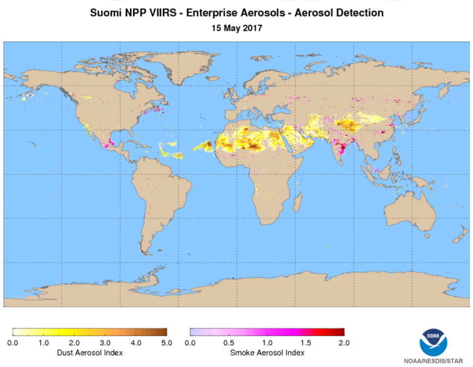
fileDescription: Example of Suomi NPP VIIRS Enterprise Aerosols from May 15, 2017. Image courtesy of NOAA JPSS LTM system.
fileType: PNG
descriptiveKeywords: (MD_Keywords)
keyword: Earth Science > Atmosphere > Aerosols > Particulate Matter
keyword: Earth Science > Atmosphere > Aerosols > Dust/Ash/Smoke
type: (MD_KeywordTypeCode) theme
thesaurusName: (CI_Citation)
title: Global Change Master Directory (GCMD) Science Keywords
date: (CI_Date)
date: 2018
dateType: (CI_DateTypeCode) revision
edition: Version 8.6
citedResponsibleParty: (CI_ResponsibleParty)
organisationName: Global Change Data Center, Science and Exploration Directorate, Goddard Space Flight Center (GSFC) National Aeronautics and Space Administration (NASA)
contactInfo: (CI_Contact)
onlineResource: (CI_OnlineResource)
linkage: https://earthdata.nasa.gov/about/gcmd/global-change-master-directory-gcmd-keywords
protocol: HTTPS
applicationProfile: Web Browser
name: Global Change Master Directory (GCMD) Keywords
description: The information provided on this page seeks to define how the GCMD Keywords are structured, used and accessed. It also provides information on how users can participate in the further development of the keywords.
function: (CI_OnLineFunctionCode) information
role: (CI_RoleCode) publisher
descriptiveKeywords: (MD_Keywords)
keyword: Atmospheric - Composition - Aerosol Properties
type: (MD_KeywordTypeCode) theme
thesaurusName: (CI_Citation)
title: Global Climate Observing System (GCOS) Essential Climate Variables (ECVs)
date: (CI_Date)
date: 2017
dateType: (CI_DateTypeCode) publication
edition: Release 2017
citedResponsibleParty: (CI_ResponsibleParty)
organisationName: World Meteorological Organization, United Nations
contactInfo: (CI_Contact)
onlineResource: (CI_OnlineResource)
linkage: https://public.wmo.int/en/programmes/global-climate-observing-system/essential-climate-variables
protocol: HTTP
applicationProfile: Information
name: GCOS Essential Climate Variables
description: Overview of the GCOS Essential Climate Variables.
function: (CI_OnLineFunctionCode) information
role: (CI_RoleCode) custodian
descriptiveKeywords: (MD_Keywords)
keyword: Geographic Region > Global
type: (MD_KeywordTypeCode) place
thesaurusName: (CI_Citation)
title: Global Change Master Directory (GCMD) Location Keywords
date: (CI_Date)
date: 2018
dateType: (CI_DateTypeCode) revision
edition: Version 8.6
citedResponsibleParty: (CI_ResponsibleParty)
organisationName: Global Change Data Center, Science and Exploration Directorate, Goddard Space Flight Center (GSFC) National Aeronautics and Space Administration (NASA)
contactInfo: (CI_Contact)
onlineResource: (CI_OnlineResource)
linkage: https://earthdata.nasa.gov/about/gcmd/global-change-master-directory-gcmd-keywords
protocol: HTTPS
applicationProfile: Web Browser
name: Global Change Master Directory (GCMD) Keywords
description: The information provided on this page seeks to define how the GCMD Keywords are structured, used and accessed. It also provides information on how users can participate in the further development of the keywords.
function: (CI_OnLineFunctionCode) information
role: (CI_RoleCode) publisher
descriptiveKeywords: (MD_Keywords)
keyword: Vertical Location > Troposphere
type: (MD_KeywordTypeCode) stratum
thesaurusName: (CI_Citation)
title: Global Change Master Directory (GCMD) Location Keywords
date: (CI_Date)
date: 2018
dateType: (CI_DateTypeCode) revision
edition: Version 8.6
citedResponsibleParty: (CI_ResponsibleParty)
organisationName: Global Change Data Center, Science and Exploration Directorate, Goddard Space Flight Center (GSFC) National Aeronautics and Space Administration (NASA)
contactInfo: (CI_Contact)
onlineResource: (CI_OnlineResource)
linkage: https://earthdata.nasa.gov/about/gcmd/global-change-master-directory-gcmd-keywords
protocol: HTTPS
applicationProfile: Web Browser
name: Global Change Master Directory (GCMD) Keywords
description: The information provided on this page seeks to define how the GCMD Keywords are structured, used and accessed. It also provides information on how users can participate in the further development of the keywords.
function: (CI_OnLineFunctionCode) information
role: (CI_RoleCode) publisher
descriptiveKeywords: (MD_Keywords)
keyword: NOAA OneStop Project
keyword: JPSS > Joint Polar Satellite System
type: (MD_KeywordTypeCode) project
thesaurusName: (CI_Citation)
title: Global Change Master Directory (GCMD) Project Keywords
date: (CI_Date)
date: 2018
dateType: (CI_DateTypeCode) revision
edition: Version 8.6
citedResponsibleParty: (CI_ResponsibleParty)
organisationName: Global Change Data Center, Science and Exploration Directorate, Goddard Space Flight Center (GSFC) National Aeronautics and Space Administration (NASA)
contactInfo: (CI_Contact)
onlineResource: (CI_OnlineResource)
linkage: https://earthdata.nasa.gov/about/gcmd/global-change-master-directory-gcmd-keywords
protocol: HTTPS
applicationProfile: Web Browser
name: Global Change Master Directory (GCMD) Keywords
description: The information provided on this page seeks to define how the GCMD Keywords are structured, used and accessed. It also provides information on how users can participate in the further development of the keywords.
function: (CI_OnLineFunctionCode) information
role: (CI_RoleCode) publisher
descriptiveKeywords: (MD_Keywords)
keyword: VIIRS > Visible-Infrared Imager-Radiometer Suite
type: (MD_KeywordTypeCode) instrument
thesaurusName: (CI_Citation)
title: Global Change Master Directory (GCMD) Instrument Keywords
date: (CI_Date)
date: 2018
dateType: (CI_DateTypeCode) revision
edition: Version 8.6
citedResponsibleParty: (CI_ResponsibleParty)
organisationName: Global Change Data Center, Science and Exploration Directorate, Goddard Space Flight Center (GSFC) National Aeronautics and Space Administration (NASA)
contactInfo: (CI_Contact)
onlineResource: (CI_OnlineResource)
linkage: https://earthdata.nasa.gov/about/gcmd/global-change-master-directory-gcmd-keywords
protocol: HTTPS
applicationProfile: Web Browser
name: Global Change Master Directory (GCMD) Keywords
description: The information provided on this page seeks to define how the GCMD Keywords are structured, used and accessed. It also provides information on how users can participate in the further development of the keywords.
function: (CI_OnLineFunctionCode) information
role: (CI_RoleCode) publisher
descriptiveKeywords: (MD_Keywords)
keyword: SUOMI-NPP > Suomi National Polar-orbiting Partnership
keyword: NOAA-20 > Joint Polar Satellite System - 1
type: (MD_KeywordTypeCode) platform
thesaurusName: (CI_Citation)
title: Global Change Master Directory (GCMD) Platform Keywords
date: (CI_Date)
date: 2018
dateType: (CI_DateTypeCode) revision
edition: Version 8.6
citedResponsibleParty: (CI_ResponsibleParty)
organisationName: Global Change Data Center, Science and Exploration Directorate, Goddard Space Flight Center (GSFC) National Aeronautics and Space Administration (NASA)
contactInfo: (CI_Contact)
onlineResource: (CI_OnlineResource)
linkage: https://earthdata.nasa.gov/about/gcmd/global-change-master-directory-gcmd-keywords
protocol: HTTPS
applicationProfile: Web Browser
name: Global Change Master Directory (GCMD) Keywords
description: The information provided on this page seeks to define how the GCMD Keywords are structured, used and accessed. It also provides information on how users can participate in the further development of the keywords.
function: (CI_OnLineFunctionCode) information
role: (CI_RoleCode) publisher
descriptiveKeywords: (MD_Keywords)
keyword: 1 km - < 10 km or approximately .01 degree - < .09 degree
type: (MD_KeywordTypeCode) dataResolution
thesaurusName: (CI_Citation)
title: Global Change Master Directory (GCMD) Horizontal Data Resolution Keywords
date: (CI_Date)
date: 2018
dateType: (CI_DateTypeCode) revision
edition: Version 8.6
citedResponsibleParty: (CI_ResponsibleParty)
organisationName: Global Change Data Center, Science and Exploration Directorate, Goddard Space Flight Center (GSFC) National Aeronautics and Space Administration (NASA)
contactInfo: (CI_Contact)
onlineResource: (CI_OnlineResource)
linkage: https://earthdata.nasa.gov/about/gcmd/global-change-master-directory-gcmd-keywords
protocol: HTTPS
applicationProfile: Web Browser
name: Global Change Master Directory (GCMD) Keywords
description: The information provided on this page seeks to define how the GCMD Keywords are structured, used and accessed. It also provides information on how users can participate in the further development of the keywords.
function: (CI_OnLineFunctionCode) information
role: (CI_RoleCode) publisher
descriptiveKeywords: (MD_Keywords)
keyword: 100 meters - < 1 km
type: (MD_KeywordTypeCode) dataResolution
thesaurusName: (CI_Citation)
title: Global Change Master Directory (GCMD) Vertical Data Resolution Keywords
date: (CI_Date)
date: 2018
dateType: (CI_DateTypeCode) revision
edition: Version 8.6
citedResponsibleParty: (CI_ResponsibleParty)
organisationName: Global Change Data Center, Science and Exploration Directorate, Goddard Space Flight Center (GSFC) National Aeronautics and Space Administration (NASA)
contactInfo: (CI_Contact)
onlineResource: (CI_OnlineResource)
linkage: https://earthdata.nasa.gov/about/gcmd/global-change-master-directory-gcmd-keywords
protocol: HTTPS
applicationProfile: Web Browser
name: Global Change Master Directory (GCMD) Keywords
description: The information provided on this page seeks to define how the GCMD Keywords are structured, used and accessed. It also provides information on how users can participate in the further development of the keywords.
function: (CI_OnLineFunctionCode) information
role: (CI_RoleCode) publisher
descriptiveKeywords: (MD_Keywords)
keyword: Daily - < Weekly
type: (MD_KeywordTypeCode) dataResolution
thesaurusName: (CI_Citation)
title: Global Change Master Directory (GCMD) Temporal Data Resolution Keywords
date: (CI_Date)
date: 2018
dateType: (CI_DateTypeCode) revision
edition: Version 8.6
citedResponsibleParty: (CI_ResponsibleParty)
organisationName: Global Change Data Center, Science and Exploration Directorate, Goddard Space Flight Center (GSFC) National Aeronautics and Space Administration (NASA)
contactInfo: (CI_Contact)
onlineResource: (CI_OnlineResource)
linkage: https://earthdata.nasa.gov/about/gcmd/global-change-master-directory-gcmd-keywords
protocol: HTTPS
applicationProfile: Web Browser
name: Global Change Master Directory (GCMD) Keywords
description: The information provided on this page seeks to define how the GCMD Keywords are structured, used and accessed. It also provides information on how users can participate in the further development of the keywords.
function: (CI_OnLineFunctionCode) information
role: (CI_RoleCode) publisher
descriptiveKeywords: (MD_Keywords)
keyword: DOC/NOAA/NESDIS/STAR > Center for Satellite Applications and Research, NESDIS, NOAA, U.S. Department of Commerce
keyword: DOC/NOAA/NESDIS/NCDC > National Climatic Data Center, NESDIS, NOAA, U.S. Department of Commerce
keyword: DOC/NOAA/NESDIS/NCEI > National Centers for Environmental Information, NESDIS, NOAA, U.S. Department of Commerce
keyword: DOC/NOAA/NESDIS/OSPO > Office of Satellite and Product Operations, NESDIS, NOAA, U.S. Department of Commerce
type: (MD_KeywordTypeCode) dataCentre
thesaurusName: (CI_Citation)
title: Global Change Master Directory (GCMD) Data Center Keywords
date: (CI_Date)
date: 2018
dateType: (CI_DateTypeCode) revision
edition: Version 8.6
citedResponsibleParty: (CI_ResponsibleParty)
organisationName: Global Change Data Center, Science and Exploration Directorate, Goddard Space Flight Center (GSFC) National Aeronautics and Space Administration (NASA)
contactInfo: (CI_Contact)
onlineResource: (CI_OnlineResource)
linkage: https://earthdata.nasa.gov/about/gcmd/global-change-master-directory-gcmd-keywords
protocol: HTTPS
applicationProfile: Web Browser
name: Global Change Master Directory (GCMD) Keywords
description: The information provided on this page seeks to define how the GCMD Keywords are structured, used and accessed. It also provides information on how users can participate in the further development of the keywords.
function: (CI_OnLineFunctionCode) information
role: (CI_RoleCode) publisher
descriptiveKeywords: (MD_Keywords)
keyword: Edr > Environmental Data Record
keyword: Nde > Nesdis Data Exploitation
type: (MD_KeywordTypeCode) theme
thesaurusName: (CI_Citation)
title: Keyword Thesaurus Title
date: (missing)
descriptiveKeywords: (MD_Keywords)
keyword: gov.noaa.class:JPSS_GRAN
type: (MD_KeywordTypeCode) other
resourceConstraints: (MD_Constraints)
useLimitation: For a complete description of use limitations for this product, see the Algorithm Theoretical Basis Document (ATBD).
resourceConstraints: (MD_LegalConstraints)
useConstraints: (MD_RestrictionCode) otherRestrictions
otherConstraints: Cite as: Kondragunta, Shoba, Laszlo, Istavan, Ma, Liqun, NOAA JPSS Program Office (2017): NOAA JPSS Visible Infrared Imaging Radiometer Suite (VIIRS) Aerosol Detection Environmental Data Record (EDR) from NDE. [indicate subset used]. NOAA National Centers for Environmental Information. doi:10.7289/V56T0JWH. [access date].
resourceConstraints: (MD_LegalConstraints)
accessConstraints: (MD_RestrictionCode) otherRestrictions
otherConstraints: Distribution liability: NOAA and NCEI make no warranty, expressed or implied, regarding these data, nor does the fact of distribution constitute such a warranty. NOAA and NCEI cannot assume liability for any damages caused by any errors or omissions in these data. If appropriate, NCEI can only certify that the data it distributes are an authentic copy of the records that were accepted for inclusion in the NCEI archives.
resourceConstraints: (MD_LegalConstraints)
useConstraints: (MD_RestrictionCode) otherRestrictions
otherConstraints: Use liability: NOAA and NCEI cannot provide any warranty as to the accuracy, reliability, or completeness of furnished data. Users assume responsibility to determine the usability of these data. The user is responsible for the results of any application of this data for other than its intended purpose.
aggregationInfo: (MD_AggregateInformation)
aggregateDataSetName: (CI_Citation)
title: Validation and expected error estimation of Suomi-NPP VIIRS aerosol optical thickness and Ångström exponent with AERONET
date: (CI_Date)
date: 2016-06-23
dateType: (CI_DateTypeCode) publication
identifier: (MD_Identifier)
code: doi:10.1002/2016JD024834
citedResponsibleParty: (CI_ResponsibleParty)
organisationName: Wiley
role: (CI_RoleCode) publisher
citedResponsibleParty: (CI_ResponsibleParty)
organisationName: (missing)
contactInfo: (CI_Contact)
onlineResource: (CI_OnlineResource)
linkage: https://doi.org/10.1002/2016JD024834
protocol: HTTPS
applicationProfile: Web Browser
name: Journal article published June 2016 by the Wiley (Journal of Geophysical Research Atmospheres)
description: Huang, J., Kondragunta, S., et al, (2016), Validation and Expected Error Estimation of Suomi-NPP VIIRS Aerosol Optical Thickness and Ångström Exponent with AERONET, J. of Geo. Res. Atmo., 121(12), 7139—7160, doi:10.1002/2016JD024834.
function: (CI_OnLineFunctionCode) information
role: (missing)
associationType: (DS_AssociationTypeCode) crossReference
initiativeType: (DS_InitiativeTypeCode) sciencePaper
aggregationInfo: (MD_AggregateInformation)
aggregateDataSetName: (CI_Citation)
title: NOAA JPSS Visible Infrared Imaging Radiometer Suite (VIIRS) Aerosol Optical Thickness (AOT) and Aerosol Particle Size Parameter (APSP) Environmental Data Record (EDR) from IDPS
date: (CI_Date)
date: 2012-05-02
dateType: (CI_DateTypeCode) publication
edition: Validated
citedResponsibleParty: (CI_ResponsibleParty)
organisationName: DOC/NOAA/NESDIS/NCEI > National Centers for Environmental Information, NESDIS, NOAA, U.S. Department of Commerce
role: (CI_RoleCode) distributor
citedResponsibleParty: (CI_ResponsibleParty)
organisationName: (missing)
contactInfo: (CI_Contact)
onlineResource: (CI_OnlineResource)
linkage: https://www.ncei.noaa.gov/metadata/geoportal/rest/metadata/item/gov.noaa.ncdc:C01402/html
protocol: HTTPS
applicationProfile: Web Browser
name: NOAA JPSS Visible Infrared Imaging Radiometer Suite (VIIRS) Aerosol Optical Thickness (AOT) and Aerosol Particle Size Parameter (APSP) Environmental Data Record (EDR) from IDPS
description: Landing page for the older version of this dataset from IDPS
function: (CI_OnLineFunctionCode) information
role: (missing)
associationType: (DS_AssociationTypeCode) crossReference
initiativeType: (DS_InitiativeTypeCode) collection
spatialRepresentationType: (MD_SpatialRepresentationTypeCode) grid
spatialResolution: (MD_Resolution)
distance:
Distance: 1000
language: eng; USA
topicCategory: (MD_TopicCategoryCode) climatologyMeteorologyAtmosphere
topicCategory: (MD_TopicCategoryCode) health
extent: (EX_Extent)
geographicElement: (EX_GeographicBoundingBox)
extentTypeCode: 1
westBoundLongitude: -180.0
eastBoundLongitude: 180.0
southBoundLatitude: -90.0
northBoundLatitude: 90.0
temporalElement: (EX_TemporalExtent)
extent:
TimePeriod:
description: ground condition
beginPosition: 2017-07-06
endPosition:
timeInterval: 24
return to top
contentInfo: (MI_CoverageDescription)
attributeDescription:
RecordType: JRR-ADP_v1r1_npp_sYYYYMMDDHHMMSSS_eYYYYMMDDHHMMSSS_cYYYYMMDDHHMMSSS.nc
contentType: (MD_CoverageContentTypeCode) physicalMeasurement
dimension: (MD_Band)
sequenceIdentifier:
MemberName:
aName: Latitude
attributeType:
TypeName:
aName: float
descriptor: Latitude
units: http://example.org/someUnitsDictionary.xml#degrees_north
dimension: (MD_Band)
sequenceIdentifier:
MemberName:
aName: Longitude
attributeType:
TypeName:
aName: float
descriptor: Longitude
units: http://example.org/someUnitsDictionary.xml#degrees_east
dimension: (MD_Band)
sequenceIdentifier:
MemberName:
aName: StartRow
attributeType:
TypeName:
aName: int
descriptor: Start row index
dimension: (MD_Band)
sequenceIdentifier:
MemberName:
aName: StartColumn
attributeType:
TypeName:
aName: int
descriptor: Start column index
dimension: (MD_Band)
sequenceIdentifier:
MemberName:
aName: Ash
attributeType:
TypeName:
aName: byte
descriptor: Vocanic Ash Flag: 1 Yes, 0 No
units: http://example.org/someUnitsDictionary.xml#1
dimension: (MD_Band)
sequenceIdentifier:
MemberName:
aName: Cloud
attributeType:
TypeName:
aName: byte
descriptor: Cloud Flag: 1 Yes, 0 No
units: http://example.org/someUnitsDictionary.xml#1
dimension: (MD_Band)
sequenceIdentifier:
MemberName:
aName: Dust
attributeType:
TypeName:
aName: byte
descriptor: Deep Blue Dust Flag: 1 Yes, 0 No
units: http://example.org/someUnitsDictionary.xml#1
dimension: (MD_Band)
sequenceIdentifier:
MemberName:
aName: Smoke
attributeType:
TypeName:
aName: byte
descriptor: Deep Blue Smoke Flag: 1 Yes, 0 No
units: http://example.org/someUnitsDictionary.xml#1
dimension: (MD_Band)
sequenceIdentifier:
MemberName:
aName: NUC
attributeType:
TypeName:
aName: byte
descriptor: None, Unknown, Clear_sky Flag: 1 Yes, 0 No
units: http://example.org/someUnitsDictionary.xml#1
dimension: (MD_Band)
sequenceIdentifier:
MemberName:
aName: SnowIce
attributeType:
TypeName:
aName: byte
descriptor: Snow Ice Flag: 1 Yes, 0 No
units: http://example.org/someUnitsDictionary.xml#1
dimension: (MD_Band)
sequenceIdentifier:
MemberName:
aName: Byte1
attributeType:
TypeName:
aName: byte
descriptor: Quality Flag Byte 1
units: http://example.org/someUnitsDictionary.xml#1
dimension: (MD_Band)
sequenceIdentifier:
MemberName:
aName: Byte2
attributeType:
TypeName:
aName: byte
descriptor: Quality Flag Byte 2
units: http://example.org/someUnitsDictionary.xml#1
dimension: (MD_Band)
sequenceIdentifier:
MemberName:
aName: Byte3
attributeType:
TypeName:
aName: byte
descriptor: Quality Flag Byte 3
units: http://example.org/someUnitsDictionary.xml#1
dimension: (MD_Band)
sequenceIdentifier:
MemberName:
aName: Byte4
attributeType:
TypeName:
aName: byte
descriptor: Quality Flag Byte 4
units: http://example.org/someUnitsDictionary.xml#1
dimension: (MD_Band)
sequenceIdentifier:
MemberName:
aName: Byte5
attributeType:
TypeName:
aName: byte
descriptor: Quality Flag Byte 5
units: http://example.org/someUnitsDictionary.xml#1
dimension: (MD_Band)
sequenceIdentifier:
MemberName:
aName: DAII
attributeType:
TypeName:
aName: float
descriptor: Dust Aerosol Index
units: http://example.org/someUnitsDictionary.xml#1
dimension: (MD_Band)
sequenceIdentifier:
MemberName:
aName: NDAI
attributeType:
TypeName:
aName: float
descriptor: No Dust Aerosol Index
units: http://example.org/someUnitsDictionary.xml#1
dimension: (MD_Band)
sequenceIdentifier:
MemberName:
aName: SmokeCon
attributeType:
TypeName:
aName: float
descriptor: Smoke Concentration
units: http://example.org/someUnitsDictionary.xml#ug%2Fm%5E3
dimension: (MD_Band)
sequenceIdentifier:
MemberName:
aName: TotalPixel
attributeType:
TypeName:
aName: int
descriptor: Total number of pixels where retrievals are attempted
units: http://example.org/someUnitsDictionary.xml#1
dimension: (MD_Band)
sequenceIdentifier:
MemberName:
aName: NumOfQualityFlag
attributeType:
TypeName:
aName: int
descriptor: Number of quality flag
units: http://example.org/someUnitsDictionary.xml#1
dimension: (MD_Band)
sequenceIdentifier:
MemberName:
aName: NumOfGoodSmokeRetrieval
attributeType:
TypeName:
aName: int
descriptor: Number of good smoke retrievals
units: http://example.org/someUnitsDictionary.xml#1
dimension: (MD_Band)
sequenceIdentifier:
MemberName:
aName: SmokePct
attributeType:
TypeName:
aName: float
descriptor: Percent of good smoke retrieval
units: http://example.org/someUnitsDictionary.xml#%25
dimension: (MD_Band)
sequenceIdentifier:
MemberName:
aName: NoSmokePct
attributeType:
TypeName:
aName: float
descriptor: Percent of smoke not determined (bad)
units: http://example.org/someUnitsDictionary.xml#%25
dimension: (MD_Band)
sequenceIdentifier:
MemberName:
aName: SmokeConfidLowPct
attributeType:
TypeName:
aName: float
descriptor: Percent of low confidence smoke
units: http://example.org/someUnitsDictionary.xml#%25
dimension: (MD_Band)
sequenceIdentifier:
MemberName:
aName: SmokeConfidMediumPct
attributeType:
TypeName:
aName: float
descriptor: Percent of medium confidence smoke
units: http://example.org/someUnitsDictionary.xml#%25
dimension: (MD_Band)
sequenceIdentifier:
MemberName:
aName: SmokeConfidHighPct
attributeType:
TypeName:
aName: float
descriptor: Percent of high confidence smoke
units: http://example.org/someUnitsDictionary.xml#%25
dimension: (MD_Band)
sequenceIdentifier:
MemberName:
aName: NumOfGoodDustRetrieval
attributeType:
TypeName:
aName: int
descriptor: Number of Good Dust Retrievals
units: http://example.org/someUnitsDictionary.xml#1
dimension: (MD_Band)
sequenceIdentifier:
MemberName:
aName: DustPct
attributeType:
TypeName:
aName: float
descriptor: Percent of good dust retrieval
units: http://example.org/someUnitsDictionary.xml#%25
dimension: (MD_Band)
sequenceIdentifier:
MemberName:
aName: NoDustPct
attributeType:
TypeName:
aName: float
descriptor: Percent of dust not determined (bad)
units: http://example.org/someUnitsDictionary.xml#%25
dimension: (MD_Band)
sequenceIdentifier:
MemberName:
aName: DustConfidLowPct
attributeType:
TypeName:
aName: float
descriptor: Percent of low confidence dust
units: http://example.org/someUnitsDictionary.xml#%25
dimension: (MD_Band)
sequenceIdentifier:
MemberName:
aName: DustConfidMediumPct
attributeType:
TypeName:
aName: float
descriptor: Percent of medium confidence dust
units: http://example.org/someUnitsDictionary.xml#%25
dimension: (MD_Band)
sequenceIdentifier:
MemberName:
aName: DustConfidHighPct
attributeType:
TypeName:
aName: float
descriptor: Percent of high confidence dust
units: http://example.org/someUnitsDictionary.xml#%25
dimension: (MD_Band)
sequenceIdentifier:
MemberName:
aName: NumOfGoodAshRetrieval
attributeType:
TypeName:
aName: int
descriptor: Number of Good Ash Retrievals
units: http://example.org/someUnitsDictionary.xml#1
dimension: (MD_Band)
sequenceIdentifier:
MemberName:
aName: AshPct
attributeType:
TypeName:
aName: float
descriptor: Percent of good ash retrieval
units: http://example.org/someUnitsDictionary.xml#%25
dimension: (MD_Band)
sequenceIdentifier:
MemberName:
aName: NoAshPct
attributeType:
TypeName:
aName: float
descriptor: Percent of ash not determined (bad)
units: http://example.org/someUnitsDictionary.xml#%25
dimension: (MD_Band)
sequenceIdentifier:
MemberName:
aName: AshConfidLowPct
attributeType:
TypeName:
aName: float
descriptor: Percent of low confidence ash
units: http://example.org/someUnitsDictionary.xml#%25
dimension: (MD_Band)
sequenceIdentifier:
MemberName:
aName: AshConfidMediumPct
attributeType:
TypeName:
aName: float
descriptor: Percent of medium confidence ash
units: http://example.org/someUnitsDictionary.xml#%25
dimension: (MD_Band)
sequenceIdentifier:
MemberName:
aName: AshConfidHighPct
attributeType:
TypeName:
aName: float
descriptor: Percent of high confidence ash
units: http://example.org/someUnitsDictionary.xml#%25
dimension: (MD_Band)
sequenceIdentifier:
MemberName:
aName: NumOfGoodNUCRetrieval
attributeType:
TypeName:
aName: int
descriptor: Number of Good NUC Retrievals
units: http://example.org/someUnitsDictionary.xml#1
dimension: (MD_Band)
sequenceIdentifier:
MemberName:
aName: NUCPct
attributeType:
TypeName:
aName: float
descriptor: Percent of good NUC retrieval
units: http://example.org/someUnitsDictionary.xml#%25
dimension: (MD_Band)
sequenceIdentifier:
MemberName:
aName: NoNUCPct
attributeType:
TypeName:
aName: float
descriptor: Percent of NUC not determined (bad)
units: http://example.org/someUnitsDictionary.xml#%25
dimension: (MD_Band)
sequenceIdentifier:
MemberName:
aName: NUCConfidLowPct
attributeType:
TypeName:
aName: float
descriptor: Percent of low confidence NUC
units: http://example.org/someUnitsDictionary.xml#%25
dimension: (MD_Band)
sequenceIdentifier:
MemberName:
aName: NUCConfidMediumPct
attributeType:
TypeName:
aName: float
descriptor: Percent of medium confidence NUC
units: http://example.org/someUnitsDictionary.xml#%25
dimension: (MD_Band)
sequenceIdentifier:
MemberName:
aName: NUCConfidHighPct
attributeType:
TypeName:
aName: float
descriptor: Percent of high confidence NUC
units: http://example.org/someUnitsDictionary.xml#%25
dimension: (MD_Band)
sequenceIdentifier:
MemberName:
aName: NumOfSolZenAngLess60
attributeType:
TypeName:
aName: int
descriptor: Number of pixel with solar zenith angle less 60 degree
units: http://example.org/someUnitsDictionary.xml#1
dimension: (MD_Band)
sequenceIdentifier:
MemberName:
aName: NumOfSatZenAngLess60
attributeType:
TypeName:
aName: int
descriptor: Number of pixel with satellite zenith angle less 60 degree
units: http://example.org/someUnitsDictionary.xml#1
return to top
distributionInfo: (MD_Distribution)
distributor: (MD_Distributor)
distributorContact: (CI_ResponsibleParty)
organisationName: NOAA National Centers for Environmental Information
contactInfo: (CI_Contact)
address: (CI_Address)
electronicMailAddress: ncei.info@noaa.gov
onlineResource: (CI_OnlineResource)
linkage: https://www.ncei.noaa.gov/contact
name: NCEI Contact Information
description: Information for contacts at NCEI.
function: (CI_OnLineFunctionCode) information
role: (CI_RoleCode) distributor
distributionOrderProcess: (MD_StandardOrderProcess)
fees: In most cases, electronic downloads of the data are free. However, fees may apply for custom orders, data certifications, copies of analog materials, and data distribution on physical media.
orderingInstructions: Contact NCEI for other distribution options and instructions.
distributorFormat: (MD_Format)
name: NetCDF
version: 4
distributorTransferOptions: (MD_DigitalTransferOptions)
onLine: (CI_OnlineResource)
linkage: https://doi.org/10.7289/V56T0JWH
protocol: HTTPS
applicationProfile: Landing Page
name: NCEI Dataset Landing Page
description: Landing page for the dataset.
function: (CI_OnLineFunctionCode) information
distributorTransferOptions: (MD_DigitalTransferOptions)
onLine: (CI_OnlineResource)
linkage: ftp://ftp-jpss.avl.class.noaa.gov/
applicationProfile: Download
name: NOAA CLASS FTP Server
description: Access and download data tar files by date and product for the previous 85 days. The directory structure is as follows, date(yyyymmdd)->instrument family->product.
function: (CI_OnLineFunctionCode) download
distributorTransferOptions: (MD_DigitalTransferOptions)
onLine: (CI_OnlineResource)
linkage: http://www.class.noaa.gov/saa/products/search?datatype_family=JPSS_GRAN
protocol: HTTPS
applicationProfile: Data Search Application
name: NOAA CLASS Data Search and Order
description: Search the data archive and submit an order for the dataset via the interface.
function: (CI_OnLineFunctionCode) order
distributorTransferOptions: (MD_DigitalTransferOptions)
onLine: (CI_OnlineResource)
linkage: https://www.star.nesdis.noaa.gov/jpss/aerosols.php
protocol: HTTPS
applicationProfile: Information
name: JPSS Aerosols Team Page
description: STAR project landing page with documentation and contact info for the dataset.
function: (CI_OnLineFunctionCode) information
distributorTransferOptions: (MD_DigitalTransferOptions)
onLine: (CI_OnlineResource)
linkage: https://www.star.nesdis.noaa.gov/smcd/emb/viirs_aerosol/index.php
protocol: HTTPS
applicationProfile: Information
name: STAR Aerosol Calibration and Validation Page
description: Aerosol project website.
function: (CI_OnLineFunctionCode) information
return to top
dataQualityInfo: (DQ_DataQuality)
scope: (DQ_Scope)
level: (MD_ScopeCode) dataset
extent: #boundingExtent
lineage: (LI_Lineage)
statement: The data were produced by the NOAA Office of Satellite and Product Operations (OSPO) NDE/PDA and are archived at the NOAA National Centers for Environmental Information (NCEI).
processStep: (LE_ProcessStep)
description: For a complete description of the processing steps, see the Algorithm Theoretical Basis Document and Data Flow Diagram.
dateTime: (missing)
processor: (CI_ResponsibleParty)
organisationName: DOC/NOAA/NESDIS/STAR > Center for Satellite Applications and Research, NESDIS, NOAA, U.S. Department of Commerce
role: (CI_RoleCode) processor
source: sd001
processingInformation: (LE_Processing)
identifier: (missing)
documentation: (CI_Citation)
title: JPSS STAR Science Documents
date: (missing)
citedResponsibleParty: (CI_ResponsibleParty)
organisationName: DOC/NOAA/NESDIS/STAR/SMCD > Satellite Meteorology and Climatology Division, Center for Satellite Applications and Research, NESDIS, NOAA, U.S. Department of Commerce
role: (CI_RoleCode) publisher
citedResponsibleParty: (CI_ResponsibleParty)
organisationName: (missing)
contactInfo: (CI_Contact)
onlineResource: (CI_OnlineResource)
linkage: https://www.star.nesdis.noaa.gov/jpss/Docs.php
protocol: HTTPS
applicationProfile: Web Browser
name: JPSS STAR Science Documents
description: Includes the Algorithm Maturity Reviews, Readmes, and User Guides.
function: (CI_OnLineFunctionCode) information
role: (missing)
processStep: (LE_ProcessStep)
description: The S-NPP VIIRS Aerosol Detection algorithm reached beta maturity.
dateTime:
DateTime: 2013-04-30T00:00:00
processor: (CI_ResponsibleParty)
organisationName: (missing)
role: (CI_RoleCode) processor
processingInformation: (LE_Processing)
identifier: (missing)
documentation: (CI_Citation)
title: JPSS STAR Algorithm Maturity Matrix
date: (missing)
citedResponsibleParty: (CI_ResponsibleParty)
organisationName: DOC/NOAA/NESDIS/STAR > Center for Satellite Applications and Research, NESDIS, NOAA, U.S. Department of Commerce
role: (CI_RoleCode) publisher
citedResponsibleParty: (CI_ResponsibleParty)
organisationName: (missing)
contactInfo: (CI_Contact)
onlineResource: (CI_OnlineResource)
linkage: https://www.star.nesdis.noaa.gov/jpss/AlgorithmMaturity.php
protocol: HTTPS
applicationProfile: Web Browser
name: JPSS STAR Algorithm Maturity Matrix
description: Table with algorithm maturity reviews by product.
function: (CI_OnLineFunctionCode) information
role: (missing)
processStep: (LE_ProcessStep)
description: The S-NPP VIIRS Aerosol Detection algorithm reached provisional maturity.
dateTime:
DateTime: 2015-12-15T00:00:00
processor: (CI_ResponsibleParty)
organisationName: (missing)
role: (CI_RoleCode) processor
processStep: (LE_ProcessStep)
description: The S-NPP VIIRS Aerosol Detection algorithm reached validated maturity.
dateTime:
DateTime: 2017-07-07T00:00:00
processor: (CI_ResponsibleParty)
organisationName: (missing)
role: (CI_RoleCode) processor
processStep: (LE_ProcessStep)
description: The NOAA-20 VIIRS Aerosol Detection algorithm reached beta maturity.
dateTime:
DateTime: 2018-04-18T00:00:00
processor: (CI_ResponsibleParty)
organisationName: (missing)
role: (CI_RoleCode) processor
processStep: (LE_ProcessStep)
description: The NOAA-20 VIIRS Aerosol Detection algorithm reached provisional maturity.
dateTime:
DateTime: 2018-04-18T00:00:00
processor: (CI_ResponsibleParty)
organisationName: (missing)
role: (CI_RoleCode) processor
processStep: (LE_ProcessStep)
description: The NOAA-20 VIIRS Aerosol Detection algorithm reached validated maturity.
dateTime:
DateTime: 2019-05-16T00:00:00
processor: (CI_ResponsibleParty)
organisationName: (missing)
role: (CI_RoleCode) processor
source: (LE_Source)
description: Sensor Data Record (SDR)
sourceCitation: (CI_Citation)
title: NOAA JPSS Visible Infrared Imaging Radiometer Suite (VIIRS) Sensor Data Record (SDR) from IDPS
date: (CI_Date)
date: 2012-02-07
dateType: (CI_DateTypeCode) publication
edition: Validated
identifier: (MD_Identifier)
code: doi:10.7289/V58G8HSZ
citedResponsibleParty: (CI_ResponsibleParty)
organisationName: DOC/NOAA/NESDIS/NCEI > National Centers for Environmental Information, NESDIS, NOAA, U.S. Department of Commerce
role: (CI_RoleCode) distributor
citedResponsibleParty: (CI_ResponsibleParty)
organisationName: (missing)
contactInfo: (CI_Contact)
onlineResource: (CI_OnlineResource)
linkage: https://doi.org/10.7289/V58G8HSZ
protocol: HTTPS
applicationProfile: Web Browser
name: NCEI landing page for JPSS-VIIRS-SDR
description: Source dataset landing page with general information and access links for the dataset.
function: (CI_OnLineFunctionCode) information
role: (missing)
sourceExtent: (EX_Extent)
geographicElement: (EX_GeographicBoundingBox)
extentTypeCode: 1
westBoundLongitude: -180
eastBoundLongitude: 180
southBoundLatitude: -90
northBoundLatitude: 90
temporalElement: (EX_TemporalExtent)
extent:
TimePeriod:
beginPosition: 2012-02-07
endPosition:
sourceStep: ps001
return to top
dataQualityInfo: (DQ_DataQuality)
scope: (DQ_Scope)
level: (MD_ScopeCode) repository
levelDescription: (MD_ScopeDescription)
other: NOAA National Centers for Environmental Information
lineage: (LI_Lineage)
processStep: (LE_ProcessStep)
description: NOAA created the National Centers for Environmental Information (NCEI) by merging NOAA's National Climatic Data Center (NCDC), National Geophysical Data Center (NGDC), and National Oceanographic Data Center (NODC), including the National Coastal Data Development Center (NCDDC), per the Consolidated and Further Continuing Appropriations Act, 2015, Public Law 113-235. NCEI launched publicly on April 22, 2015.
dateTime:
DateTime: 2015-04-22T00:00:00
return to top
dataQualityInfo: (DQ_DataQuality)
scope: (DQ_Scope)
level: (MD_ScopeCode) series
levelDescription: (MD_ScopeDescription)
other: Data Stewardship
report: (DQ_ConceptualConsistency)
nameOfMeasure: Data Stewardship Maturity Assessment
measureIdentification: (MD_Identifier)
code: MM-Stew
measureDescription: The Data Stewardship Maturity Matrix (DSMM) is a unified framework that defines criteria for each of nine components based on measurable practices, which can be used to apply a progressive, 6-level rating to an individual dataset, representing stewardship maturity stages rated as Not Assessed or Not Available (Level 0), adHoc (Level 1), minimum (Level 2), intermediate (Level 3), advanced (Level 4), and optimal (Level 5).
evaluationMethodDescription: Data Stewardship Maturity Assessment was evaluated by the metadata content editor for the NOAA OneStop project using the Scientific Data Stewardship Maturity Assessment Model Template v4.0.
evaluationProcedure: (CI_Citation)
title: The Scientific Data Stewardship Maturity Assessment Model Template
date: (CI_Date)
date: 2015-06-23
dateType: (CI_DateTypeCode) publication
edition: NCDC-CICS-SMM_0001_Rev.1 v4.0 06/23/2015
identifier: (MD_Identifier)
code:
Anchor: DOI link doi:10.10.6084/m9.figshare.1211954
citedResponsibleParty: (CI_ResponsibleParty)
individualName: Peng, Ge
organisationName: CICS-NC/NCEI
role: (CI_RoleCode) author
citedResponsibleParty: (CI_ResponsibleParty)
organisationName: (inapplicable)
contactInfo: (CI_Contact)
onlineResource: (CI_OnlineResource)
linkage: https://doi.org/10.6084/m9.figshare.1211954
protocol: HTTPS
applicationProfile: Web Browser
name: The Scientific Data Stewardship Maturity Assessment Model Template
description: Landing page for quality evaluation procedure.
function: (CI_OnLineFunctionCode) information
role: (inapplicable)
presentationForm: (CI_PresentationFormCode) documentDigital
dateTime:
DateTime: 2017-08-30T00:00:00
result: (DQ_QuantitativeResult)
valueUnit: (inapplicable)
value:
Record:
CodeListValue: advanced
value:
Record:
CodeListValue: optimal
value:
Record:
CodeListValue: advanced
value:
Record:
CodeListValue: advanced
value:
Record:
CodeListValue: advanced
value:
Record:
CodeListValue: advanced
value:
Record:
CodeListValue: intermediate
value:
Record:
CodeListValue: intermediate
value:
Record:
CodeListValue: optimal
result: (DQ_ConformanceResult)
specification: (CI_Citation)
title: VIIRS_ADP_NDE
date: (CI_Date)
date: 2017-08-30
dateType: (CI_DateTypeCode) publication
edition: v01r00
citedResponsibleParty: (CI_ResponsibleParty)
organisationName: DOC/NOAA/NESDIS/NCEI > National Centers for Environmental Information, NESDIS, NOAA, U.S. Department of Commerce
role: (CI_RoleCode) publisher
citedResponsibleParty: (CI_ResponsibleParty)
organisationName: (missing)
contactInfo: (CI_Contact)
onlineResource: (CI_OnlineResource)
linkage: (template)
role: (missing)
explanation: Data Stewardship Maturity Assessment was evaluated by the metadata content editor for the NOAA OneStop project using the Scientific Data Stewardship Maturity Assessment Model Template v4.0.
pass: (inapplicable)
return to top
metadataMaintenance: (MD_MaintenanceInformation)
maintenanceAndUpdateFrequency: (MD_MaintenanceFrequencyCode) asNeeded
maintenanceNote: Bulk metadata change applied on 2023-06-23. See version control repository history for metadata change details.