NOAA GOES-R Series Advanced Baseline Imager (ABI) Level 1b Radiances
- referenceSystemInfo
- identificationInfo
- contentInfo
- distributionInfo
- dataQualityInfo
- dataQualityInfo
- dataQualityInfo
- metadataMaintenance
(MI_Metadata)
fileIdentifier: gov.noaa.ncdc:C01501
language: eng; USA
characterSet: (MD_CharacterSetCode) utf8
hierarchyLevel: (MD_ScopeCode) dataset
contact: (CI_ResponsibleParty)
organisationName: NOAA National Centers for Environmental Information
contactInfo: (CI_Contact)
address: (CI_Address)
electronicMailAddress: ncei.info@noaa.gov
onlineResource: (CI_OnlineResource)
linkage: https://www.ncei.noaa.gov/contact
name: NCEI Contact Information
description: Information for contacts at NCEI.
function: (CI_OnLineFunctionCode) information
role: (CI_RoleCode) pointOfContact
dateStamp: 2023-09-18
metadataStandardName: ISO 19115-2 Geographic Information - Metadata - Part 2: Extensions for Imagery and Gridded Data
metadataStandardVersion: ISO 19115-2:2009(E)
return to top
referenceSystemInfo: (MD_ReferenceSystem)
referenceSystemIdentifier: (RS_Identifier)
authority: (CI_Citation)
title: EPSG Geodetic Parameter Dataset Registry
date: (CI_Date)
date: 2008-11-12
dateType: (CI_DateTypeCode) publication
citedResponsibleParty: (CI_ResponsibleParty)
organisationName: International Association of Oil and Gas Producers (OGP) Geomatics Committee
contactInfo: (CI_Contact)
onlineResource: (CI_OnlineResource)
linkage: http://www.epsg-registry.org/
applicationProfile: Data Search Application
name: EPSG Geodetic Parameter Dataset Registry Application
description: Interface to the EPSG Geodetic Parameter Dataset Registry
function: (CI_OnLineFunctionCode) search
role: (CI_RoleCode) custodian
citedResponsibleParty: (CI_ResponsibleParty)
organisationName: International Association of Oil and Gas Producers (OGP) Geomatics Committee
contactInfo: (CI_Contact)
onlineResource: (CI_OnlineResource)
linkage: http://www.epsg-registry.org/export.htm?gml=urn:ogc:def:crs:EPSG::4326
applicationProfile: Download
name: Coordinate Reference System data in GML
description: Coordinate Reference System data in GML
function: (CI_OnLineFunctionCode) download
role: (CI_RoleCode) custodian
code: urn:ogc:def:crs:EPSG::4326
version: (unknown)
return to top
identificationInfo: (MD_DataIdentification)
citation: (CI_Citation)
title: NOAA GOES-R Series Advanced Baseline Imager (ABI) Level 1b Radiances
alternateTitle: ABI-L1b-Rad
date: (CI_Date)
date: 2017-06-01
dateType: (CI_DateTypeCode) publication
edition: Full Validation
identifier: (MD_Identifier)
code:
Anchor: DOI doi:10.7289/V5BV7DSR
identifier: (MD_Identifier)
code: ABI-L1b-Rad
identifier: (MD_Identifier)
code: gov.noaa.ncdc:C01501
identifier: (MD_Identifier)
code: gov.noaa.class:GRABIPRD
citedResponsibleParty: (CI_ResponsibleParty)
organisationName: NOAA National Centers for Environmental Information
role: (CI_RoleCode) publisher
citedResponsibleParty: (CI_ResponsibleParty)
organisationName: GOES-R Calibration Working Group
role: (CI_RoleCode) principalInvestigator
citedResponsibleParty: (CI_ResponsibleParty)
organisationName: GOES-R Calibration Working Group
role: (CI_RoleCode) author
citedResponsibleParty: (CI_ResponsibleParty)
organisationName: GOES-R Series Program
role: (CI_RoleCode) resourceProvider
citedResponsibleParty: (CI_ResponsibleParty)
organisationName: GOES-R Series Program
role: (CI_RoleCode) author
abstract: The Advanced Baseline Imager (ABI) operates on board the NOAA Geostationary Operational Environmental Satellite-R (GOES-R) Series weather satellites providing advanced imagery and atmospheric measurements of Earth’s Western Hemisphere. The Advanced Baseline Imager (ABI) instrument samples the radiance of the Earth in sixteen spectral bands using several arrays of detectors in the instrument’s focal plane. Single reflective band ABI Level 1b Radiance Products (channels 1 - 6 with approximate center wavelengths 0.47, 0.64, 0.865, 1.378, 1.61, 2.25 microns, respectively) are digital maps of outgoing radiance values at the top of the atmosphere for visible and near-infrared (IR) bands. Single emissive band ABI L1b Radiance Products (channels 7 - 16 with approximate center wavelengths 3.9, 6.185, 6.95, 7.34, 8.5, 9.61, 10.35, 11.2, 12.3, 13.3 microns, respectively) are digital maps of outgoing radiance values at the top of the atmosphere for IR bands. Detector samples are compressed, packetized and down-linked to the ground station as Level 0 data for conversion to calibrated, geo-located pixels (Level 1b Radiance data). The detector samples are decompressed, radiometrically corrected, navigated and resampled onto an invariant output grid, referred to as the ABI fixed grid. There are three spatial coverage scenes per satellite (GOES East and GOES West): Full Disk is the full hemispheric view; Contiguous U.S. is the lower 48 states; and Mesoscale 1 and 2 are for weather event views.
purpose: Data provided by the 16 spectral channels are used to generate Level 2 and higher products, and are also used in numerical weather prediction models, aiding meteorologists and others in monitoring and predicting all kinds of weather and other phenomena.
status: (MD_ProgressCode) onGoing
pointOfContact: (CI_ResponsibleParty)
individualName: Customer Engagement Branch
organisationName: DOC/NOAA/NESDIS/NCEI > National Centers for Environmental Information, NESDIS, NOAA, U.S. Department of Commerce
contactInfo: (CI_Contact)
address: (CI_Address)
electronicMailAddress: ncei.sat.info@noaa.gov
role: (CI_RoleCode) pointOfContact
resourceMaintenance: (MD_MaintenanceInformation)
maintenanceAndUpdateFrequency: (MD_MaintenanceFrequencyCode) continual
graphicOverview: (MD_BrowseGraphic)
fileName: https://www.ncei.noaa.gov/pub/data/metadata/images/smallABIL1bdata.gif
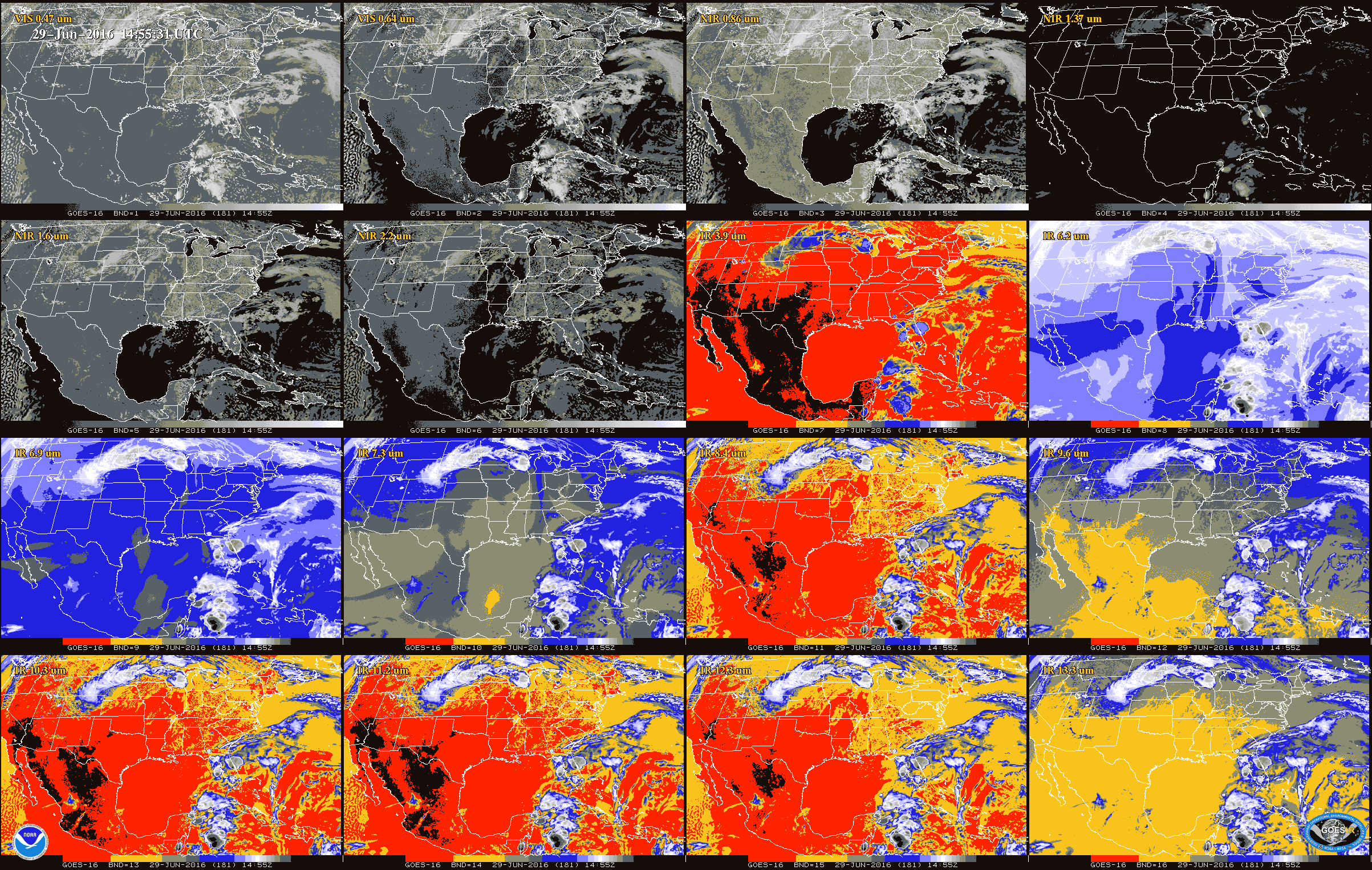
fileDescription: Example of ABI L1b data for each of the 16 bands.
fileType: GIF
descriptiveKeywords: (MD_Keywords)
keyword: Earth Science > Spectral/Engineering > Visible Wavelengths > Visible Radiance
keyword: Earth Science > Spectral/Engineering > Infrared Wavelengths > Infrared Radiance
type: (MD_KeywordTypeCode) theme
thesaurusName: (CI_Citation)
title: Global Change Master Directory (GCMD) Science Keywords
date: (CI_Date)
date: 2018
dateType: (CI_DateTypeCode) revision
edition: Version 8.6
citedResponsibleParty: (CI_ResponsibleParty)
organisationName: Global Change Data Center, Science and Exploration Directorate, Goddard Space Flight Center (GSFC) National Aeronautics and Space Administration (NASA)
contactInfo: (CI_Contact)
onlineResource: (CI_OnlineResource)
linkage: https://earthdata.nasa.gov/about/gcmd/global-change-master-directory-gcmd-keywords
protocol: HTTPS
applicationProfile: Web Browser
name: Global Change Master Directory (GCMD) Keywords
description: The information provided on this page seeks to define how the GCMD Keywords are structured, used and accessed. It also provides information on how users can participate in the further development of the keywords.
function: (CI_OnLineFunctionCode) information
role: (CI_RoleCode) publisher
descriptiveKeywords: (MD_Keywords)
keyword: Geographic Region > Equatorial
keyword: Geographic Region > Mid-Latitude
keyword: Geographic Region > Northern Hemisphere
keyword: Geographic Region > Southern Hemisphere
keyword: Geographic Region > Western Hemisphere
keyword: Geographic Region > Tropics
keyword: Continent > North America > United States Of America
keyword: Continent > North America > Central America
keyword: Continent > South America
keyword: Ocean > Atlantic Ocean
keyword: Ocean > Pacific Ocean
type: (MD_KeywordTypeCode) place
thesaurusName: (CI_Citation)
title: Global Change Master Directory (GCMD) Location Keywords
date: (CI_Date)
date: 2018
dateType: (CI_DateTypeCode) revision
edition: Version 8.6
citedResponsibleParty: (CI_ResponsibleParty)
organisationName: Global Change Data Center, Science and Exploration Directorate, Goddard Space Flight Center (GSFC) National Aeronautics and Space Administration (NASA)
contactInfo: (CI_Contact)
onlineResource: (CI_OnlineResource)
linkage: https://earthdata.nasa.gov/about/gcmd/global-change-master-directory-gcmd-keywords
protocol: HTTPS
applicationProfile: Web Browser
name: Global Change Master Directory (GCMD) Keywords
description: The information provided on this page seeks to define how the GCMD Keywords are structured, used and accessed. It also provides information on how users can participate in the further development of the keywords.
function: (CI_OnLineFunctionCode) information
role: (CI_RoleCode) publisher
descriptiveKeywords: (MD_Keywords)
keyword: GOES > Geostationary Operational Environmental Satellites
keyword: ABI-L1b-Rad
keyword: gov.noaa.class:GRABIPRD
keyword: GRABIPRD
keyword: NOAA OneStop Project
type: (MD_KeywordTypeCode) project
thesaurusName: (CI_Citation)
title: Global Change Master Directory (GCMD) Project Keywords
date: (CI_Date)
date: 2018
dateType: (CI_DateTypeCode) revision
edition: Version 8.6
citedResponsibleParty: (CI_ResponsibleParty)
organisationName: Global Change Data Center, Science and Exploration Directorate, Goddard Space Flight Center (GSFC) National Aeronautics and Space Administration (NASA)
contactInfo: (CI_Contact)
onlineResource: (CI_OnlineResource)
linkage: https://earthdata.nasa.gov/about/gcmd/global-change-master-directory-gcmd-keywords
protocol: HTTPS
applicationProfile: Web Browser
name: Global Change Master Directory (GCMD) Keywords
description: The information provided on this page seeks to define how the GCMD Keywords are structured, used and accessed. It also provides information on how users can participate in the further development of the keywords.
function: (CI_OnLineFunctionCode) information
role: (CI_RoleCode) publisher
descriptiveKeywords: (MD_Keywords)
keyword: ABI > Advanced Baseline Imager
type: (MD_KeywordTypeCode) instrument
thesaurusName: (CI_Citation)
title: Global Change Master Directory (GCMD) Instrument Keywords
date: (CI_Date)
date: 2018
dateType: (CI_DateTypeCode) revision
edition: Version 8.6
citedResponsibleParty: (CI_ResponsibleParty)
organisationName: Global Change Data Center, Science and Exploration Directorate, Goddard Space Flight Center (GSFC) National Aeronautics and Space Administration (NASA)
contactInfo: (CI_Contact)
onlineResource: (CI_OnlineResource)
linkage: https://earthdata.nasa.gov/about/gcmd/global-change-master-directory-gcmd-keywords
protocol: HTTPS
applicationProfile: Web Browser
name: Global Change Master Directory (GCMD) Keywords
description: The information provided on this page seeks to define how the GCMD Keywords are structured, used and accessed. It also provides information on how users can participate in the further development of the keywords.
function: (CI_OnLineFunctionCode) information
role: (CI_RoleCode) publisher
descriptiveKeywords: (MD_Keywords)
keyword: GOES-16 > Geostationary Operational Environmental Satellite 16
keyword: GOES-17 > Geostationary Operational Environmental Satellite 17
keyword: GOES-18 > Geostationary Operational Environmental Satellite 18
type: (MD_KeywordTypeCode) platform
thesaurusName: (CI_Citation)
title: Global Change Master Directory (GCMD) Platform Keywords
date: (CI_Date)
date: 2018
dateType: (CI_DateTypeCode) revision
edition: Version 8.6
citedResponsibleParty: (CI_ResponsibleParty)
organisationName: Global Change Data Center, Science and Exploration Directorate, Goddard Space Flight Center (GSFC) National Aeronautics and Space Administration (NASA)
contactInfo: (CI_Contact)
onlineResource: (CI_OnlineResource)
linkage: https://earthdata.nasa.gov/about/gcmd/global-change-master-directory-gcmd-keywords
protocol: HTTPS
applicationProfile: Web Browser
name: Global Change Master Directory (GCMD) Keywords
description: The information provided on this page seeks to define how the GCMD Keywords are structured, used and accessed. It also provides information on how users can participate in the further development of the keywords.
function: (CI_OnLineFunctionCode) information
role: (CI_RoleCode) publisher
descriptiveKeywords: (MD_Keywords)
keyword: 1 km - < 10 km or approximately .01 degree - < .09 degree
keyword: 500 meters - < 1 km
type: (MD_KeywordTypeCode) dataResolution
thesaurusName: (CI_Citation)
title: Global Change Master Directory (GCMD) Horizontal Data Resolution Keywords
date: (CI_Date)
date: 2018
dateType: (CI_DateTypeCode) revision
edition: Version 8.6
citedResponsibleParty: (CI_ResponsibleParty)
organisationName: Global Change Data Center, Science and Exploration Directorate, Goddard Space Flight Center (GSFC) National Aeronautics and Space Administration (NASA)
contactInfo: (CI_Contact)
onlineResource: (CI_OnlineResource)
linkage: https://earthdata.nasa.gov/about/gcmd/global-change-master-directory-gcmd-keywords
protocol: HTTPS
applicationProfile: Web Browser
name: Global Change Master Directory (GCMD) Keywords
description: The information provided on this page seeks to define how the GCMD Keywords are structured, used and accessed. It also provides information on how users can participate in the further development of the keywords.
function: (CI_OnLineFunctionCode) information
role: (CI_RoleCode) publisher
descriptiveKeywords: (MD_Keywords)
keyword: 1 minute - < 1 hour
keyword: 1 second - < 1 minute
type: (MD_KeywordTypeCode) dataResolution
thesaurusName: (CI_Citation)
title: Global Change Master Directory (GCMD) Temporal Data Resolution Keywords
date: (CI_Date)
date: 2018
dateType: (CI_DateTypeCode) revision
edition: Version 8.6
citedResponsibleParty: (CI_ResponsibleParty)
organisationName: Global Change Data Center, Science and Exploration Directorate, Goddard Space Flight Center (GSFC) National Aeronautics and Space Administration (NASA)
contactInfo: (CI_Contact)
onlineResource: (CI_OnlineResource)
linkage: https://earthdata.nasa.gov/about/gcmd/global-change-master-directory-gcmd-keywords
protocol: HTTPS
applicationProfile: Web Browser
name: Global Change Master Directory (GCMD) Keywords
description: The information provided on this page seeks to define how the GCMD Keywords are structured, used and accessed. It also provides information on how users can participate in the further development of the keywords.
function: (CI_OnLineFunctionCode) information
role: (CI_RoleCode) publisher
descriptiveKeywords: (MD_Keywords)
keyword: DOC/NOAA/NESDIS/NCDC > National Climatic Data Center, NESDIS, NOAA, U.S. Department of Commerce
keyword: DOC/NOAA/NESDIS/NCEI > National Centers for Environmental Information, NESDIS, NOAA, U.S. Department of Commerce
keyword: DOC/NOAA/NESDIS/STAR > Center for Satellite Applications and Research, NESDIS, NOAA, U.S. Department of Commerce
keyword: DOC/NOAA/NESDIS/OSPO > Office of Satellite and Product Operations, NESDIS, NOAA, U.S. Department of Commerce
type: (MD_KeywordTypeCode) dataCentre
thesaurusName: (CI_Citation)
title: Global Change Master Directory (GCMD) Data Center Keywords
date: (CI_Date)
date: 2018
dateType: (CI_DateTypeCode) revision
edition: Version 8.6
citedResponsibleParty: (CI_ResponsibleParty)
organisationName: Global Change Data Center, Science and Exploration Directorate, Goddard Space Flight Center (GSFC) National Aeronautics and Space Administration (NASA)
contactInfo: (CI_Contact)
onlineResource: (CI_OnlineResource)
linkage: https://earthdata.nasa.gov/about/gcmd/global-change-master-directory-gcmd-keywords
protocol: HTTPS
applicationProfile: Web Browser
name: Global Change Master Directory (GCMD) Keywords
description: The information provided on this page seeks to define how the GCMD Keywords are structured, used and accessed. It also provides information on how users can participate in the further development of the keywords.
function: (CI_OnLineFunctionCode) information
role: (CI_RoleCode) publisher
descriptiveKeywords: (MD_Keywords)
keyword: gov.noaa.class:GRABIPRD
type: (MD_KeywordTypeCode) project
resourceConstraints: (MD_Constraints)
useLimitation: For a complete set of limitations for this dataset see the Algorithm Theoretical Basis Document (ATBD).
resourceConstraints: (MD_LegalConstraints)
useConstraints: (MD_RestrictionCode) otherRestrictions
otherConstraints: Cite as: GOES-R Calibration Working Group and GOES-R Series Program, (2017): NOAA GOES-R Series Advanced Baseline Imager (ABI) Level 1b Radiances. [indicate subset used]. NOAA National Centers for Environmental Information. doi:10.7289/V5BV7DSR. [access date].
resourceConstraints: (MD_LegalConstraints)
accessConstraints: (MD_RestrictionCode) otherRestrictions
otherConstraints: Distribution liability: NOAA and NCEI make no warranty, expressed or implied, regarding these data, nor does the fact of distribution constitute such a warranty. NOAA and NCEI cannot assume liability for any damages caused by any errors or omissions in these data. If appropriate, NCEI can only certify that the data it distributes are an authentic copy of the records that were accepted for inclusion in the NCEI archives.
resourceConstraints: (MD_LegalConstraints)
useConstraints: (MD_RestrictionCode) otherRestrictions
otherConstraints: Use liability: NOAA and NCEI cannot provide any warranty as to the accuracy, reliability, or completeness of furnished data. Users assume responsibility to determine the usability of these data. The user is responsible for the results of any application of this data for other than its intended purpose.
aggregationInfo: (MD_AggregateInformation)
aggregateDataSetName: (CI_Citation)
title: GOES-R Program Document Library
date: (missing)
citedResponsibleParty: (CI_ResponsibleParty)
organisationName: (missing)
contactInfo: (CI_Contact)
onlineResource: (CI_OnlineResource)
linkage: https://www.goes-r.gov/resources/docs.html
applicationProfile: Web Browser
name: GOES-R Program Document Library
description: Webpage with product algorithm, users guides, and education and outreach materials.
function: (CI_OnLineFunctionCode) information
role: (missing)
associationType: (DS_AssociationTypeCode) crossReference
initiativeType: (DS_InitiativeTypeCode) userGuide
aggregationInfo: (MD_AggregateInformation)
aggregateDataSetName: (CI_Citation)
title: GOES Operational Status - NOAA Office of Satellite and Product Operations
date: (missing)
citedResponsibleParty: (CI_ResponsibleParty)
organisationName: (missing)
contactInfo: (CI_Contact)
onlineResource: (CI_OnlineResource)
linkage: https://www.ospo.noaa.gov/Operations/GOES/status.html
applicationProfile: Web Browser
name: GOES Operational Status - NOAA Office of Satellite and Product Operations
description: GOES spacecraft status page.
function: (CI_OnLineFunctionCode) information
role: (missing)
associationType: (DS_AssociationTypeCode) crossReference
initiativeType: (DS_InitiativeTypeCode) userGuide
aggregationInfo: (MD_AggregateInformation)
aggregateDataSetName: (CI_Citation)
title: Advanced Baseline Imager Scan Mode Information
date: (missing)
citedResponsibleParty: (CI_ResponsibleParty)
organisationName: (missing)
contactInfo: (CI_Contact)
onlineResource: (CI_OnlineResource)
linkage: https://www.goes-r.gov/users/abiScanModeInfo.html
applicationProfile: Web Browser
name: Advanced Baseline Imager Scan Mode Information
description: Information on the ABI scan modes.
function: (CI_OnLineFunctionCode) information
role: (missing)
associationType: (DS_AssociationTypeCode) crossReference
initiativeType: (DS_InitiativeTypeCode) userGuide
aggregationInfo: (MD_AggregateInformation)
aggregateDataSetName: (CI_Citation)
title: GOES-R ABI Bands Quick Information Guides
date: (missing)
citedResponsibleParty: (CI_ResponsibleParty)
organisationName: (missing)
contactInfo: (CI_Contact)
onlineResource: (CI_OnlineResource)
linkage: https://www.goes-r.gov/mission/ABI-bands-quick-info.html
applicationProfile: Web Browser
name: GOES-R ABI Bands Quick Information Guides
description: The fact sheets are designed as quick reference guides to provide users with information on each of the GOES-R series Advanced Baseline Imager's 16 spectral bands.
function: (CI_OnLineFunctionCode) information
role: (missing)
associationType: (DS_AssociationTypeCode) crossReference
initiativeType: (DS_InitiativeTypeCode) userGuide
aggregationInfo: (MD_AggregateInformation)
aggregateDataSetName: (CI_Citation)
title: GOES-17 ABI Performance
date: (missing)
citedResponsibleParty: (CI_ResponsibleParty)
organisationName: (missing)
contactInfo: (CI_Contact)
onlineResource: (CI_OnlineResource)
linkage: https://www.goes-r.gov/users/GOES-17-ABI-Performance.html
applicationProfile: Web Browser
name: GOES-17 ABI Performance
description: Summary of the cooling system issue.
function: (CI_OnLineFunctionCode) information
role: (missing)
associationType: (DS_AssociationTypeCode) crossReference
initiativeType: (DS_InitiativeTypeCode) userGuide
aggregationInfo: (MD_AggregateInformation)
aggregateDataSetName: (CI_Citation)
title: A Closer Look at the ABI on the GOES-R Series.
date: (CI_Date)
date: 2017-04-24
dateType: (CI_DateTypeCode) publication
identifier: (MD_Identifier)
code: doi:10.1175/BAMS-D-15-00230.1
citedResponsibleParty: (CI_ResponsibleParty)
organisationName: AMS > American Meteorological Society
role: (CI_RoleCode) publisher
citedResponsibleParty: (CI_ResponsibleParty)
organisationName: (missing)
contactInfo: (CI_Contact)
onlineResource: (CI_OnlineResource)
linkage: https://doi.org/10.1175/BAMS-D-15-00230.1
protocol: HTTPS
applicationProfile: Web Browser
name: Journal article published April 2017 by the AMS (Bulletin of American Meteorological Society).
description: Schmit, T., Griffith, P., et al, (2017), A closer look at the ABI on the GOES-R series, Bull. Amer. Meteor. Soc., 98(4), 681-698, doi:10.1175/BAMS-D-15-00230.1.
function: (CI_OnLineFunctionCode) information
role: (missing)
associationType: (DS_AssociationTypeCode) crossReference
initiativeType: (DS_InitiativeTypeCode) sciencePaper
spatialRepresentationType: (MD_SpatialRepresentationTypeCode) grid
spatialResolution: (MD_Resolution)
distance:
Distance: 500
spatialResolution: (MD_Resolution)
distance:
Distance: 1000
spatialResolution: (MD_Resolution)
distance:
Distance: 2000
language: eng; USA
topicCategory: (MD_TopicCategoryCode) climatologyMeteorologyAtmosphere
extent: (EX_Extent)
geographicElement: (EX_GeographicBoundingBox)
extentTypeCode: 1
westBoundLongitude: 141.7005
eastBoundLongitude: 6.2995
southBoundLatitude: -81.3282
northBoundLatitude: 81.3282
geographicElement: (EX_GeographicBoundingBox)
extentTypeCode: 1
westBoundLongitude: -156.2995
eastBoundLongitude: 6.2995
southBoundLatitude: -81.3282
northBoundLatitude: 81.3282
geographicElement: (EX_GeographicBoundingBox)
extentTypeCode: 1
westBoundLongitude: 141.7005
eastBoundLongitude: -55.7005
southBoundLatitude: -81.3282
northBoundLatitude: 81.3282
temporalElement: (EX_TemporalExtent)
extent:
TimePeriod:
description: ground condition
beginPosition: 2017-02-28
endPosition:
timeInterval: 10
return to top
contentInfo: (MI_CoverageDescription)
attributeDescription:
RecordType: OR_ABI-L1b-RadM2-M3C02_G16_sYYYYDDDHHMMSS_eYYYYDDDHHMMSS_cYYYYDDDHHMMSS.nc
contentType: (MD_CoverageContentTypeCode) physicalMeasurement
dimension: (MD_Band)
sequenceIdentifier:
MemberName:
aName: Rad
attributeType:
TypeName:
aName: short
descriptor: ABI L1b Radiances (toa_outgoing_radiance_per_unit_wavelength)
units: http://example.org/someUnitsDictionary.xml#W%20m-2%20sr-1%20um-1
dimension: (MD_Band)
sequenceIdentifier:
MemberName:
aName: DQF
attributeType:
TypeName:
aName: byte
descriptor: ABI L1b Radiances data quality flags (status_flag)
units: http://example.org/someUnitsDictionary.xml#1
dimension: (MD_Band)
sequenceIdentifier:
MemberName:
aName: t
attributeType:
TypeName:
aName: double
descriptor: J2000 epoch mid-point between the start and end image scan in seconds (time)
units: http://example.org/someUnitsDictionary.xml#seconds%20since%202000-01-01%2012%3A00%3A00
dimension: (MD_Band)
sequenceIdentifier:
MemberName:
aName: y
attributeType:
TypeName:
aName: short
descriptor: GOES fixed grid projection y-coordinate (projection_y_coordinate)
units: http://example.org/someUnitsDictionary.xml#rad
dimension: (MD_Band)
sequenceIdentifier:
MemberName:
aName: x
attributeType:
TypeName:
aName: short
descriptor: GOES fixed grid projection x-coordinate (projection_x_coordinate)
units: http://example.org/someUnitsDictionary.xml#rad
dimension: (MD_Band)
sequenceIdentifier:
MemberName:
aName: time_bounds
attributeType:
TypeName:
aName: double
descriptor: Scan start and end times in seconds since epoch (2000-01-01 12:00:00)
dimension: (MD_Band)
sequenceIdentifier:
MemberName:
aName: goes_imager_projection
attributeType:
TypeName:
aName: int
descriptor: GOES-R ABI fixed grid projection
dimension: (MD_Band)
sequenceIdentifier:
MemberName:
aName: y_image
attributeType:
TypeName:
aName: float
descriptor: GOES-R fixed grid projection y-coordinate center of image (projection_y_coordinate)
units: http://example.org/someUnitsDictionary.xml#rad
dimension: (MD_Band)
sequenceIdentifier:
MemberName:
aName: y_image_bounds
attributeType:
TypeName:
aName: float
descriptor: GOES-R fixed grid projection y-coordinate north/south extent of image
dimension: (MD_Band)
sequenceIdentifier:
MemberName:
aName: x_image
attributeType:
TypeName:
aName: float
descriptor: GOES-R fixed grid projection x-coordinate center of image (projection_x_coordinate)
units: http://example.org/someUnitsDictionary.xml#rad
dimension: (MD_Band)
sequenceIdentifier:
MemberName:
aName: x_image_bounds
attributeType:
TypeName:
aName: float
descriptor: GOES-R fixed grid projection x-coordinate west/east extent of image
dimension: (MD_Band)
sequenceIdentifier:
MemberName:
aName: nominal_satellite_subpoint_lat
attributeType:
TypeName:
aName: float
descriptor: nominal satellite subpoint latitude (platform latitude) (latitude)
units: http://example.org/someUnitsDictionary.xml#degrees_north
dimension: (MD_Band)
sequenceIdentifier:
MemberName:
aName: nominal_satellite_subpoint_lon
attributeType:
TypeName:
aName: float
descriptor: nominal satellite subpoint longitude (platform longitude) (longitude)
units: http://example.org/someUnitsDictionary.xml#degrees_east
dimension: (MD_Band)
sequenceIdentifier:
MemberName:
aName: nominal_satellite_height
attributeType:
TypeName:
aName: float
descriptor: nominal satellite height above GRS 80 ellipsoid (platform altitude) (height_above_reference_ellipsoid)
units: http://example.org/someUnitsDictionary.xml#km
dimension: (MD_Band)
sequenceIdentifier:
MemberName:
aName: geospatial_lat_lon_extent
attributeType:
TypeName:
aName: float
descriptor: geospatial latitude and longitude references
dimension: (MD_Band)
sequenceIdentifier:
MemberName:
aName: yaw_flip_flag
attributeType:
TypeName:
aName: byte
descriptor: Flag indicating the spacecraft is operating in yaw flip configuration
units: http://example.org/someUnitsDictionary.xml#1
dimension: (MD_Band)
sequenceIdentifier:
MemberName:
aName: band_id
attributeType:
TypeName:
aName: byte
descriptor: ABI band number (sensor_band_identifier)
units: http://example.org/someUnitsDictionary.xml#1
dimension: (MD_Band)
sequenceIdentifier:
MemberName:
aName: band_wavelength
attributeType:
TypeName:
aName: float
descriptor: ABI band central wavelength (sensor_band_central_radiation_wavelength)
units: http://example.org/someUnitsDictionary.xml#um
dimension: (MD_Band)
sequenceIdentifier:
MemberName:
aName: esun
attributeType:
TypeName:
aName: float
descriptor: bandpass-weighted solar irradiance at the mean Earth-Sun distance (toa_shortwave_irradiance_per_unit_wavelength)
units: http://example.org/someUnitsDictionary.xml#W%20m-2%20um-1
dimension: (MD_Band)
sequenceIdentifier:
MemberName:
aName: kappa0
attributeType:
TypeName:
aName: float
descriptor: Inverse of the incoming top of atmosphere radiance at current earth-sun distance (PI d2 esun-1)-1, where d is the ratio of instantaneous Earth-Sun distance divided by the mean Earth-Sun distance, esun is the bandpass-weighted solar irradiance and PI is a standard constant used to convert ABI L1b radiance to reflectance
units: http://example.org/someUnitsDictionary.xml#%28W%20m-2%20um-1%29-1
dimension: (MD_Band)
sequenceIdentifier:
MemberName:
aName: planck_fk1
attributeType:
TypeName:
aName: float
descriptor: wavenumber-dependent coefficient (2 h c2/ nu3) used in the ABI emissive band monochromatic brightness temperature computation, where nu =central wavenumber and h and c are standard constants
units: http://example.org/someUnitsDictionary.xml#W%20m-1
dimension: (MD_Band)
sequenceIdentifier:
MemberName:
aName: planck_fk2
attributeType:
TypeName:
aName: float
descriptor: wavenumber-dependent coefficient (h c nu/b) used in the ABI emissive band monochromatic brightness temperature computation, where nu = central wavenumber and h, c, and b are standard constants
units: http://example.org/someUnitsDictionary.xml#K
dimension: (MD_Band)
sequenceIdentifier:
MemberName:
aName: planck_bc1
attributeType:
TypeName:
aName: float
descriptor: spectral bandpass correction offset for brightness temperature (B(nu) - bc_1)/bc_2 where B()=planck_function() and nu=wavenumber
units: http://example.org/someUnitsDictionary.xml#K
dimension: (MD_Band)
sequenceIdentifier:
MemberName:
aName: planck_bc2
attributeType:
TypeName:
aName: float
descriptor: spectral bandpass correction scale factor for brightness temperature (B(nu) - bc_1)/bc_2 where B()=planck_function() and nu=wavenumber
units: http://example.org/someUnitsDictionary.xml#1
dimension: (MD_Band)
sequenceIdentifier:
MemberName:
aName: valid_pixel_count
attributeType:
TypeName:
aName: int
descriptor: number of good and conditionally usable pixels
units: http://example.org/someUnitsDictionary.xml#count
dimension: (MD_Band)
sequenceIdentifier:
MemberName:
aName: missing_pixel_count
attributeType:
TypeName:
aName: int
descriptor: number of missing pixels
units: http://example.org/someUnitsDictionary.xml#count
dimension: (MD_Band)
sequenceIdentifier:
MemberName:
aName: saturated_pixel_count
attributeType:
TypeName:
aName: int
descriptor: number of saturated pixels
units: http://example.org/someUnitsDictionary.xml#count
dimension: (MD_Band)
sequenceIdentifier:
MemberName:
aName: undersaturated_pixel_count
attributeType:
TypeName:
aName: int
descriptor: number of undersaturated pixels
units: http://example.org/someUnitsDictionary.xml#count
dimension: (MD_Band)
sequenceIdentifier:
MemberName:
aName: min_radiance_value_of_valid_pixels
attributeType:
TypeName:
aName: float
descriptor: minimum radiance value of pixels (toa_outgoing_radiance_per_unit_wavelength)
units: http://example.org/someUnitsDictionary.xml#W%20m-2%20sr-1%20um-1
dimension: (MD_Band)
sequenceIdentifier:
MemberName:
aName: max_radiance_value_of_valid_pixels
attributeType:
TypeName:
aName: float
descriptor: maximum radiance value of pixels (toa_outgoing_radiance_per_unit_wavelength)
units: http://example.org/someUnitsDictionary.xml#W%20m-2%20sr-1%20um-1
dimension: (MD_Band)
sequenceIdentifier:
MemberName:
aName: mean_radiance_value_of_valid_pixels
attributeType:
TypeName:
aName: float
descriptor: mean radiance value of pixels (toa_outgoing_radiance_per_unit_wavelength)
units: http://example.org/someUnitsDictionary.xml#W%20m-2%20sr-1%20um-1
dimension: (MD_Band)
sequenceIdentifier:
MemberName:
aName: std_dev_radiance_value_of_valid_pixels
attributeType:
TypeName:
aName: float
descriptor: standard deviation of radiance values of pixels (toa_outgoing_radiance_per_unit_wavelength)
units: http://example.org/someUnitsDictionary.xml#W%20m-2%20sr-1%20um-1
dimension: (MD_Band)
sequenceIdentifier:
MemberName:
aName: percent_uncorrectable_L0_errors
attributeType:
TypeName:
aName: float
descriptor: percent data lost due to uncorrectable L0 errors
units: http://example.org/someUnitsDictionary.xml#percent
dimension: (MD_Band)
sequenceIdentifier:
MemberName:
aName: earth_sun_distance_anomaly_in_AU
attributeType:
TypeName:
aName: float
descriptor: earth sun distance anomaly in astronomical units
units: http://example.org/someUnitsDictionary.xml#ua
dimension: (MD_Band)
sequenceIdentifier:
MemberName:
aName: algorithm_dynamic_input_data_container
attributeType:
TypeName:
aName: int
descriptor: container for filenames of dynamic algorithm input data
dimension: (MD_Band)
sequenceIdentifier:
MemberName:
aName: processing_parm_version_container
attributeType:
TypeName:
aName: int
descriptor: container for processing parameter filenames
dimension: (MD_Band)
sequenceIdentifier:
MemberName:
aName: algorithm_product_version_container
attributeType:
TypeName:
aName: int
descriptor: container for algorithm package filename and product version
dimension: (MD_Band)
sequenceIdentifier:
MemberName:
aName: t_star_look
attributeType:
TypeName:
aName: double
descriptor: J2000 epoch time of star observed in seconds (time)
units: http://example.org/someUnitsDictionary.xml#seconds%20since%202000-01-01%2012%3A00%3A00
dimension: (MD_Band)
sequenceIdentifier:
MemberName:
aName: band_wavelength_star_look
attributeType:
TypeName:
aName: float
descriptor: ABI band central wavelength associated with observed star (sensor_band_central_radiation_wavelength)
units: http://example.org/someUnitsDictionary.xml#um
dimension: (MD_Band)
sequenceIdentifier:
MemberName:
aName: star_id
attributeType:
TypeName:
aName: short
descriptor: ABI star catalog identifier associated with observed star
return to top
distributionInfo: (MD_Distribution)
distributor: (MD_Distributor)
distributorContact: (CI_ResponsibleParty)
organisationName: NOAA National Centers for Environmental Information
contactInfo: (CI_Contact)
address: (CI_Address)
electronicMailAddress: ncei.info@noaa.gov
onlineResource: (CI_OnlineResource)
linkage: https://www.ncei.noaa.gov/contact
name: NCEI Contact Information
description: Information for contacts at NCEI.
function: (CI_OnLineFunctionCode) information
role: (CI_RoleCode) distributor
distributionOrderProcess: (MD_StandardOrderProcess)
fees: In most cases, electronic downloads of the data are free. However, fees may apply for custom orders, data certifications, copies of analog materials, and data distribution on physical media.
orderingInstructions: Contact NCEI for other distribution options and instructions.
distributorFormat: (MD_Format)
name: NetCDF
version: 4
distributorTransferOptions: (MD_DigitalTransferOptions)
onLine: (CI_OnlineResource)
linkage: https://doi.org/10.7289/V5BV7DSR
protocol: HTTPS
applicationProfile: Landing Page
name: NCEI Dataset Landing Page
description: Landing page for the dataset.
function: (CI_OnLineFunctionCode) information
distributorTransferOptions: (MD_DigitalTransferOptions)
onLine: (CI_OnlineResource)
linkage: https://www.ncdc.noaa.gov/airs-web/search
protocol: HTTPS
applicationProfile: Data Search Application
name: NCEI Archive Information Request System
description: Search the data archive and submit an order for the dataset via the interface.
function: (CI_OnLineFunctionCode) order
distributorTransferOptions: (MD_DigitalTransferOptions)
onLine: (CI_OnlineResource)
linkage: http://www.class.noaa.gov/saa/products/search?datatype_family=GRABIPRD
protocol: HTTPS
applicationProfile: Data Search Application
name: NOAA CLASS Data Search and Order
description: Search the data archive and submit an order for the dataset via the interface.
function: (CI_OnLineFunctionCode) order
distributorTransferOptions: (MD_DigitalTransferOptions)
onLine: (CI_OnlineResource)
linkage: https://www.ncei.noaa.gov/products/goes-terrestrial-weather-abi-glm
protocol: HTTPS
applicationProfile: Information
name: NCEI GOES-R Program Webpage
description: GOES-R Terrestrial Weather (ABI/GLM)
function: (CI_OnLineFunctionCode) information
distributorTransferOptions: (MD_DigitalTransferOptions)
onLine: (CI_OnlineResource)
linkage: https://www.goes-r.gov/users/docs/PUG-main-vol1.pdf
protocol: HTTPS
applicationProfile: Documentation
name: Product Definition and Users' Guide (PUG) Vol.1 Main
description: The Product Definition and User's Guide (PUG) document provides product descriptions and formats for all data and products produced and made available to users by the Geostationary Operational Environmental Satellite R Series (GOES-R) Core Ground Segment (GS).
function: (CI_OnLineFunctionCode) information
distributorTransferOptions: (MD_DigitalTransferOptions)
onLine: (CI_OnlineResource)
linkage: https://www.goes-r.gov/users/docs/PUG-L1b-vol3.pdf>
protocol: HTTPS
applicationProfile: Documentation
name: Product Definition and Users' Guide (PUG) Vol.3 Level 1B Products
description: The Product Definition and User's Guide (PUG) document provides product descriptions and formats for all data and products produced and made available to users by the Geostationary Operational Environmental Satellite R Series (GOES-R) Core Ground Segment (GS).
function: (CI_OnLineFunctionCode) information
distributorTransferOptions: (MD_DigitalTransferOptions)
onLine: (CI_OnlineResource)
linkage: https://registry.opendata.aws/noaa-goes/
protocol: HTTPS
applicationProfile: Information
name: Registry of Open Data on AWS
description: Information on AWS data access.
function: (CI_OnLineFunctionCode) information
distributorTransferOptions: (MD_DigitalTransferOptions)
unitsOfDistribution: Region: us-east-1
onLine: (CI_OnlineResource)
linkage: https://noaa-goes16.s3.amazonaws.com/index.html
protocol: HTTPS
applicationProfile: Download
name: GOES-16 AWS S3 Explorer (Region: us-east-1)
description: Browse view to explore the S3 bucket for GOES-16 datasets. Data relevant to this can be found in folders with the prefix ABI-L1b-Rad.
function: (CI_OnLineFunctionCode) download
distributorTransferOptions: (MD_DigitalTransferOptions)
unitsOfDistribution: Region: us-east-1
onLine: (CI_OnlineResource)
linkage: https://noaa-goes17.s3.amazonaws.com/index.html
protocol: HTTPS
applicationProfile: Download
name: GOES-17 AWS S3 Explorer (Region: us-east-1)
description: Browse view to explore the S3 bucket for GOES-17 datasets. Data relevant to this can be found in folders with the prefix ABI-L1b-Rad.
function: (CI_OnLineFunctionCode) download
distributorTransferOptions: (MD_DigitalTransferOptions)
unitsOfDistribution: Region: us-east-1
onLine: (CI_OnlineResource)
linkage: https://noaa-goes18.s3.amazonaws.com/index.html
protocol: HTTPS
applicationProfile: Download
name: GOES-18 AWS S3 Explorer (Region: us-east-1)
description: Browse view to explore the S3 bucket for GOES-18 datasets. Data relevant to this can be found in folders with the prefix ABI-L1b-Rad.
function: (CI_OnLineFunctionCode) download
distributorTransferOptions: (MD_DigitalTransferOptions)
unitsOfDistribution: Region: US-multiple
onLine: (CI_OnlineResource)
linkage: https://console.cloud.google.com/storage/browser/gcp-public-data-goes-16
protocol: HTTPS
applicationProfile: Download
name: GOES-16 Google Cloud Bucket Explorer (Region: US-multiple)
description: Browse view to explore the Google Cloud bucket for GOES-16. Data relevant to this can be found in folders with the prefix ABI-L1b-Rad.
function: (CI_OnLineFunctionCode) download
distributorTransferOptions: (MD_DigitalTransferOptions)
unitsOfDistribution: Region: US-multiple
onLine: (CI_OnlineResource)
linkage: https://console.cloud.google.com/storage/browser/gcp-public-data-goes-17
protocol: HTTPS
applicationProfile: Download
name: GOES-17 Google Cloud Bucket Explorer (Region: US-multiple)
description: Browse view to explore the Google Cloud bucket for GOES-17. Data relevant to this can be found in folders with the prefix ABI-L1b-Rad.
function: (CI_OnLineFunctionCode) download
distributorTransferOptions: (MD_DigitalTransferOptions)
unitsOfDistribution: Region: US-multiple
onLine: (CI_OnlineResource)
linkage: https://console.cloud.google.com/storage/browser/gcp-public-data-goes-18
protocol: HTTPS
applicationProfile: Download
name: GOES-18 Google Cloud Bucket Explorer (Region: US-multiple)
description: Browse view to explore the Google Cloud bucket for GOES-18. Data relevant to this can be found in folders with the prefix ABI-L1b-Rad.
function: (CI_OnLineFunctionCode) download
distributorTransferOptions: (MD_DigitalTransferOptions)
unitsOfDistribution: Region: US-multiple
onLine: (CI_OnlineResource)
linkage: https://console.cloud.google.com/launcher/details/noaa-public/goes/
protocol: HTTPS
applicationProfile: Information
name: Google Cloud Landing Page (Region: US-multiple)
description: Information on Google Cloud data access for GOES datasets.
function: (CI_OnLineFunctionCode) information
return to top
dataQualityInfo: (DQ_DataQuality)
scope: (DQ_Scope)
level: (MD_ScopeCode) dataset
extent: #boundingExtent
lineage: (LI_Lineage)
statement: These data were produced by the NOAA Office of Satellite and Product Operations (OSPO) and are archived at the NOAA National Centers for Environmental Information (NCEI).
processStep: (LE_ProcessStep)
description: Raw data downlink is received by the antenna system which processes the data through signal processing equipment to intermediate frequency. Forward error correction is performed. If FEC fails, those packets are dropped. Good packets are input to L0 processing. In L0 processing packets are uncompressed, extracted and byte-aligned (L1a). L1b processing extracts the L1a data, performs radiometric and geometric correction on the data to create L1b data.
dateTime: (missing)
processor: (CI_ResponsibleParty)
organisationName: DOC/NOAA/NESDIS/OSPO > Office of Satellite and Product Operations, NESDIS, NOAA, U.S. Department of Commerce
role: (CI_RoleCode) processor
processingInformation: (LE_Processing)
identifier: (missing)
documentation: (CI_Citation)
title: GOES-R ABI Calibration Working Group
date: (missing)
citedResponsibleParty: (CI_ResponsibleParty)
organisationName: DOC/NOAA/NESDIS/STAR > Center for Satellite Applications and Research, NESDIS, NOAA, U.S. Department of Commerce
role: (CI_RoleCode) publisher
citedResponsibleParty: (CI_ResponsibleParty)
organisationName: (missing)
contactInfo: (CI_Contact)
onlineResource: (CI_OnlineResource)
linkage: https://ncc.nesdis.noaa.gov/GOESR/index.php
protocol: HTTPS
applicationProfile: Web Browser
name: GOES-R ABI Calibration Working Group
description: Web page that contains information, multimedia, and documentation on the GOES-R calibration and validation activities.
function: (CI_OnLineFunctionCode) information
role: (missing)
documentation: (CI_Citation)
title: NOAA Satellite Information System Product Quality
date: (missing)
citedResponsibleParty: (CI_ResponsibleParty)
organisationName: (missing)
contactInfo: (CI_Contact)
onlineResource: (CI_OnlineResource)
linkage: https://www.noaasis.noaa.gov/GOES/PS_PVR2.html
protocol: HTTPS
applicationProfile: Web Browser
name: NOAA Satellite Information System Product Quality
description: Peer/Stakeholder Product Validation Reviews by satellite and product.
function: (CI_OnLineFunctionCode) information
role: (missing)
processStep: (LE_ProcessStep)
description: The GOES-16 ABI L1b Radiances algorithm reached beta maturity.
dateTime:
DateTime: 2017-03-01T15:00:00Z
processor: (CI_ResponsibleParty)
organisationName: (missing)
role: (CI_RoleCode) processor
processStep: (LE_ProcessStep)
description: The GOES-16 ABI L1b Radiances algorithm reached provisional maturity.
dateTime:
DateTime: 2017-06-01T00:00:00
processor: (CI_ResponsibleParty)
organisationName: (missing)
role: (CI_RoleCode) processor
processStep: (LE_ProcessStep)
description: The GOES-16 ABI L1b Radiances algorithm reached full validation maturity.
dateTime:
DateTime: 2018-06-01T00:00:00
processor: (CI_ResponsibleParty)
organisationName: (missing)
role: (CI_RoleCode) processor
processStep: (LE_ProcessStep)
description: The GOES-17 ABI L1b Radiances algorithm reached beta maturity.
dateTime:
DateTime: 2018-08-27T00:00:00
processor: (CI_ResponsibleParty)
organisationName: (missing)
role: (CI_RoleCode) processor
processStep: (LE_ProcessStep)
description: The GOES-17 ABI L1b Radiances algorithm reached provisional maturity.
dateTime:
DateTime: 2018-11-28T00:00:00
processor: (CI_ResponsibleParty)
organisationName: (missing)
role: (CI_RoleCode) processor
processStep: (LE_ProcessStep)
description: The GOES-17 ABI L1b Radiances algorithm reached full validation maturity.
dateTime:
DateTime: 2020-02-12T00:00:00
processor: (CI_ResponsibleParty)
organisationName: (missing)
role: (CI_RoleCode) processor
source: (LE_Source)
description: Level 0 Data
sourceCitation: (CI_Citation)
title: NOAA GOES-R Series Advanced Baseline Imager (ABI) Level 0 Products
date: (CI_Date)
date: 2017-07-10
dateType: (CI_DateTypeCode) publication
edition: Provisional
citedResponsibleParty: (CI_ResponsibleParty)
organisationName: DOC/NOAA/NESDIS/NCEI > National Centers for Environmental Information, NESDIS, NOAA, U.S. Department of Commerce
role: (CI_RoleCode) distributor
citedResponsibleParty: (CI_ResponsibleParty)
organisationName: (missing)
role: (missing)
sourceExtent: (EX_Extent)
geographicElement: (EX_GeographicBoundingBox)
extentTypeCode: 1
westBoundLongitude: -156.2995
eastBoundLongitude: 6.2995
southBoundLatitude: -81.3282
northBoundLatitude: 81.3282
geographicElement: (EX_GeographicBoundingBox)
extentTypeCode: 1
westBoundLongitude: 141.7005
eastBoundLongitude: -55.7005
southBoundLatitude: -81.3282
northBoundLatitude: 81.3282
temporalElement: (EX_TemporalExtent)
extent:
TimePeriod:
beginPosition: 2017-02-28
endPosition:
sourceStep: ps001
return to top
dataQualityInfo: (DQ_DataQuality)
scope: (DQ_Scope)
level: (MD_ScopeCode) repository
levelDescription: (MD_ScopeDescription)
other: NOAA National Centers for Environmental Information
lineage: (LI_Lineage)
processStep: (LE_ProcessStep)
description: NOAA created the National Centers for Environmental Information (NCEI) by merging NOAA's National Climatic Data Center (NCDC), National Geophysical Data Center (NGDC), and National Oceanographic Data Center (NODC), including the National Coastal Data Development Center (NCDDC), per the Consolidated and Further Continuing Appropriations Act, 2015, Public Law 113-235. NCEI launched publicly on April 22, 2015.
dateTime:
DateTime: 2015-04-22T00:00:00
return to top
dataQualityInfo: (DQ_DataQuality)
scope: (DQ_Scope)
level: (MD_ScopeCode) series
levelDescription: (MD_ScopeDescription)
other: Data Stewardship
report: (DQ_ConceptualConsistency)
nameOfMeasure: Data Stewardship Maturity Assessment
measureIdentification: (MD_Identifier)
code: MM-Stew
measureDescription: The Data Stewardship Maturity Matrix (DSMM) is a unified framework that defines criteria for each of nine components based on measurable practices, which can be used to apply a progressive, 6-level rating to an individual dataset, representing stewardship maturity stages rated as Not Assessed or Not Available (Level 0), adHoc (Level 1), minimum (Level 2), intermediate (Level 3), advanced (Level 4), and optimal (Level 5).
evaluationMethodDescription: Data Stewardship Maturity Assessment was evaluated by the metadata content editor for the NOAA OneStop project using the Scientific Data Stewardship Maturity Assessment Model Template v4.0.
evaluationProcedure: (CI_Citation)
title: The Scientific Data Stewardship Maturity Assessment Model Template
date: (CI_Date)
date: 2015-06-23
dateType: (CI_DateTypeCode) publication
edition: NCDC-CICS-SMM_0001_Rev.1 v4.0 06/23/2015
identifier: (MD_Identifier)
code:
Anchor: DOI link doi:10.10.6084/m9.figshare.1211954
citedResponsibleParty: (CI_ResponsibleParty)
individualName: Peng, Ge
organisationName: CICS-NC/NCEI
role: (CI_RoleCode) author
citedResponsibleParty: (CI_ResponsibleParty)
organisationName: (inapplicable)
contactInfo: (CI_Contact)
onlineResource: (CI_OnlineResource)
linkage: https://doi.org/10.6084/m9.figshare.1211954
protocol: HTTPS
applicationProfile: Web Browser
name: The Scientific Data Stewardship Maturity Assessment Model Template
description: Landing page for quality evaluation procedure.
function: (CI_OnLineFunctionCode) information
role: (inapplicable)
presentationForm: (CI_PresentationFormCode) documentDigital
dateTime:
DateTime: 2018-08-07T00:00:00
result: (DQ_QuantitativeResult)
valueUnit: (inapplicable)
value:
Record:
CodeListValue: advanced
value:
Record:
CodeListValue: optimal
value:
Record:
CodeListValue: intermediate
value:
Record:
CodeListValue: optimal
value:
Record:
CodeListValue: advanced
value:
Record:
CodeListValue: intermediate
value:
Record:
CodeListValue: intermediate
value:
Record:
CodeListValue: minimal
value:
Record:
CodeListValue: optimal
result: (DQ_ConformanceResult)
specification: (CI_Citation)
title: GOES16_ABI_L1BRad
date: (CI_Date)
date: 2018-08-07
dateType: (CI_DateTypeCode) publication
edition: v02r00
citedResponsibleParty: (CI_ResponsibleParty)
organisationName: DOC/NOAA/NESDIS/NCEI > National Centers for Environmental Information, NESDIS, NOAA, U.S. Department of Commerce
role: (CI_RoleCode) publisher
citedResponsibleParty: (CI_ResponsibleParty)
organisationName: (missing)
contactInfo: (CI_Contact)
onlineResource: (CI_OnlineResource)
linkage: (template)
role: (missing)
explanation: Data Stewardship Maturity Assessment was evaluated by the metadata content editor for the NOAA OneStop project using the Scientific Data Stewardship Maturity Assessment Model Template v4.0.
pass: (inapplicable)
return to top
metadataMaintenance: (MD_MaintenanceInformation)
maintenanceAndUpdateFrequency: (MD_MaintenanceFrequencyCode) asNeeded
maintenanceNote: Bulk metadata change applied on 2023-07-12. See version control repository history for metadata change details.