NOAA GOES-R Series Advanced Baseline Imager (ABI) Level 2 Aerosol Detection (ADP)
- referenceSystemInfo
- identificationInfo
- distributionInfo
- dataQualityInfo
- dataQualityInfo
- metadataMaintenance
(MI_Metadata)
fileIdentifier: gov.noaa.ncdc:C01510
language: eng; USA
characterSet: (MD_CharacterSetCode) utf8
hierarchyLevel: (MD_ScopeCode) dataset
contact: (CI_ResponsibleParty)
organisationName: NOAA National Centers for Environmental Information
contactInfo: (CI_Contact)
address: (CI_Address)
electronicMailAddress: ncei.info@noaa.gov
onlineResource: (CI_OnlineResource)
linkage: https://www.ncei.noaa.gov/contact
name: NCEI Contact Information
description: Information for contacts at NCEI.
function: (CI_OnLineFunctionCode) information
role: (CI_RoleCode) pointOfContact
dateStamp: 2023-09-18
metadataStandardName: ISO 19115-2 Geographic Information - Metadata - Part 2: Extensions for Imagery and Gridded Data
metadataStandardVersion: ISO 19115-2:2009(E)
return to top
referenceSystemInfo: (MD_ReferenceSystem)
referenceSystemIdentifier: (RS_Identifier)
authority: (CI_Citation)
title: EPSG Geodetic Parameter Dataset Registry
date: (CI_Date)
date: 2008-11-12
dateType: (CI_DateTypeCode) publication
citedResponsibleParty: (CI_ResponsibleParty)
organisationName: International Association of Oil and Gas Producers (OGP) Geomatics Committee
contactInfo: (CI_Contact)
onlineResource: (CI_OnlineResource)
linkage: http://www.epsg-registry.org/
applicationProfile: Data Search Application
name: EPSG Geodetic Parameter Dataset Registry Application
description: Interface to the EPSG Geodetic Parameter Dataset Registry
function: (CI_OnLineFunctionCode) search
role: (CI_RoleCode) custodian
citedResponsibleParty: (CI_ResponsibleParty)
organisationName: International Association of Oil and Gas Producers (OGP) Geomatics Committee
contactInfo: (CI_Contact)
onlineResource: (CI_OnlineResource)
linkage: http://www.epsg-registry.org/export.htm?gml=urn:ogc:def:crs:EPSG::4326
applicationProfile: Download
name: Coordinate Reference System data in GML
description: Coordinate Reference System data in GML
function: (CI_OnLineFunctionCode) download
role: (CI_RoleCode) custodian
code: urn:ogc:def:crs:EPSG::4326
version: (unknown)
return to top
identificationInfo: (MD_DataIdentification)
citation: (CI_Citation)
title: NOAA GOES-R Series Advanced Baseline Imager (ABI) Level 2 Aerosol Detection (ADP)
alternateTitle: ABI-L2-ADP
date: (CI_Date)
date: 2017-12-12
dateType: (CI_DateTypeCode) publication
edition: Provisional
identifier: (MD_Identifier)
code:
Anchor: DOI doi:
identifier: (MD_Identifier)
code: ABI-L2-ADP
identifier: (MD_Identifier)
code: gov.noaa.ncdc:C01510
identifier: (MD_Identifier)
code: gov.noaa.class:GRABIPRD
citedResponsibleParty: (CI_ResponsibleParty)
organisationName: NOAA National Centers for Environmental Information
role: (CI_RoleCode) publisher
citedResponsibleParty: (CI_ResponsibleParty)
organisationName: GOES-R Algorithm Working Group
role: (CI_RoleCode) principalInvestigator
citedResponsibleParty: (CI_ResponsibleParty)
organisationName: GOES-R Algorithm Working Group
role: (CI_RoleCode) author
citedResponsibleParty: (CI_ResponsibleParty)
organisationName: GOES-R Series Program
role: (CI_RoleCode) resourceProvider
citedResponsibleParty: (CI_ResponsibleParty)
organisationName: GOES-R Series Program
role: (CI_RoleCode) author
presentationForm: (CI_PresentationFormCode) imageDigital
abstract: The GOES-R Advanced Baseline Imager (ABI) Aerosol Detection product contains three images in the form of binary masks that identify the presence of aerosols, dust, and smoke. The aerosol mask indicates the presence of either smoke or dust. The dust and smoke masks indicate the presence of dust and smoke, respectively. Because the presence of smoke and dust are independently derived, a given pixel can be identified with both dust and smoke. The product includes data quality information for on-earth pixels. The binary aerosol, dust, and smoke mask values are dimensionless quantities. The Aerosol Detection product images are produced on the ABI fixed grid at 2 km resolution for Full Disk, CONUS and Mesoscale coverage regions from GOES East and West. Product data is produced under the following conditions: Clear sky; Snow-free; Geolocated source data to local zenith angles of 90 degrees and to solar zenith angles of 87 degrees.
purpose: The Aerosol Detection product will use several spectral bands made available on the GOES-R imager. The algorithm will use known spectral absorption and scattering properties of different aerosols to detect their presence in the atmosphere. The Aerosol Detection product will enable forecasters to better monitor areas of smoke and dust, which can be critical factors in visibility and air quality forecasts. In addition to short-term prediction, this product will also enable better monitoring of the long-term trends in aerosol quantities and distribution throughout the atmosphere.
status: (MD_ProgressCode) onGoing
pointOfContact: (CI_ResponsibleParty)
individualName: Customer Engagement Branch
organisationName: DOC/NOAA/NESDIS/NCEI > National Centers for Environmental Information, NESDIS, NOAA, U.S. Department of Commerce
contactInfo: (CI_Contact)
address: (CI_Address)
electronicMailAddress: ncei.sat.info@noaa.gov
role: (CI_RoleCode) pointOfContact
resourceMaintenance: (MD_MaintenanceInformation)
maintenanceAndUpdateFrequency: (MD_MaintenanceFrequencyCode) continual
graphicOverview: (MD_BrowseGraphic)
fileName: https://www.ncei.noaa.gov/pub/data/metadata/images/C01510.jpg
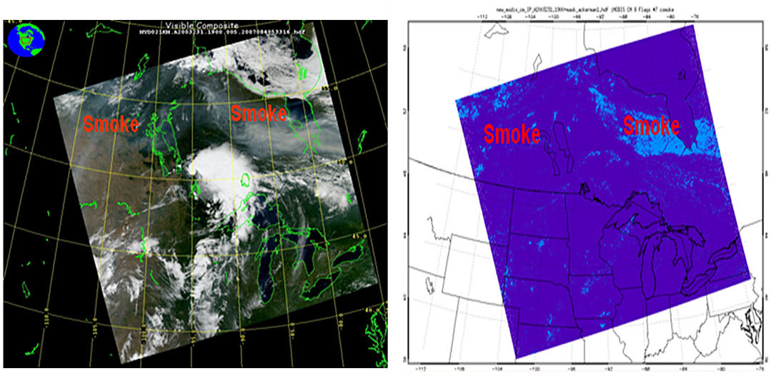
fileDescription: MODIS visible color composite image (left) of a British Columbia, Canada fire event on 19 August 2003 and the resulting smoke flag product generated by the GOES-R Aerosol Detection algorithm (right).
fileType: JPEG
descriptiveKeywords: (MD_Keywords)
keyword: Earth Science > Atmosphere > Aerosols > Dust/Ash/Smoke
type: (MD_KeywordTypeCode) theme
thesaurusName: (CI_Citation)
title: Global Change Master Directory (GCMD) Science Keywords
date: (CI_Date)
date: 2018
dateType: (CI_DateTypeCode) revision
edition: Version 8.6
citedResponsibleParty: (CI_ResponsibleParty)
organisationName: Global Change Data Center, Science and Exploration Directorate, Goddard Space Flight Center (GSFC) National Aeronautics and Space Administration (NASA)
contactInfo: (CI_Contact)
onlineResource: (CI_OnlineResource)
linkage: https://earthdata.nasa.gov/about/gcmd/global-change-master-directory-gcmd-keywords
protocol: HTTPS
applicationProfile: Web Browser
name: Global Change Master Directory (GCMD) Keywords
description: The information provided on this page seeks to define how the GCMD Keywords are structured, used and accessed. It also provides information on how users can participate in the further development of the keywords.
function: (CI_OnLineFunctionCode) information
role: (CI_RoleCode) publisher
descriptiveKeywords: (MD_Keywords)
keyword: Atmospheric - Composition - Aerosol Properties
type: (MD_KeywordTypeCode) theme
thesaurusName: (CI_Citation)
title: Global Climate Observing System (GCOS) Essential Climate Variables (ECVs)
date: (CI_Date)
date: 2017
dateType: (CI_DateTypeCode) publication
edition: Release 2017
citedResponsibleParty: (CI_ResponsibleParty)
organisationName: World Meteorological Organization, United Nations
contactInfo: (CI_Contact)
onlineResource: (CI_OnlineResource)
linkage: https://public.wmo.int/en/programmes/global-climate-observing-system/essential-climate-variables
protocol: HTTP
applicationProfile: Information
name: GCOS Essential Climate Variables
description: Overview of the GCOS Essential Climate Variables.
function: (CI_OnLineFunctionCode) information
role: (CI_RoleCode) custodian
descriptiveKeywords: (MD_Keywords)
keyword: Geographic Region > Equatorial
keyword: Geographic Region > Mid-Latitude
keyword: Geographic Region > Northern Hemisphere
keyword: Geographic Region > Southern Hemisphere
keyword: Geographic Region > Tropics
keyword: Geographic Region > Western Hemisphere
keyword: Continent > North America > United States Of America
keyword: Continent > North America > Central America
keyword: Continent > South America
keyword: Ocean > Atlantic Ocean
keyword: Ocean > Pacific Ocean
type: (MD_KeywordTypeCode) place
thesaurusName: (CI_Citation)
title: Global Change Master Directory (GCMD) Location Keywords
date: (CI_Date)
date: 2018
dateType: (CI_DateTypeCode) revision
edition: Version 8.6
citedResponsibleParty: (CI_ResponsibleParty)
organisationName: Global Change Data Center, Science and Exploration Directorate, Goddard Space Flight Center (GSFC) National Aeronautics and Space Administration (NASA)
contactInfo: (CI_Contact)
onlineResource: (CI_OnlineResource)
linkage: https://earthdata.nasa.gov/about/gcmd/global-change-master-directory-gcmd-keywords
protocol: HTTPS
applicationProfile: Web Browser
name: Global Change Master Directory (GCMD) Keywords
description: The information provided on this page seeks to define how the GCMD Keywords are structured, used and accessed. It also provides information on how users can participate in the further development of the keywords.
function: (CI_OnLineFunctionCode) information
role: (CI_RoleCode) publisher
descriptiveKeywords: (MD_Keywords)
keyword: Vertical Location > Troposphere
type: (MD_KeywordTypeCode) stratum
thesaurusName: (CI_Citation)
title: Global Change Master Directory (GCMD) Location Keywords
date: (CI_Date)
date: 2018
dateType: (CI_DateTypeCode) revision
edition: Version 8.6
citedResponsibleParty: (CI_ResponsibleParty)
organisationName: Global Change Data Center, Science and Exploration Directorate, Goddard Space Flight Center (GSFC) National Aeronautics and Space Administration (NASA)
contactInfo: (CI_Contact)
onlineResource: (CI_OnlineResource)
linkage: https://earthdata.nasa.gov/about/gcmd/global-change-master-directory-gcmd-keywords
protocol: HTTPS
applicationProfile: Web Browser
name: Global Change Master Directory (GCMD) Keywords
description: The information provided on this page seeks to define how the GCMD Keywords are structured, used and accessed. It also provides information on how users can participate in the further development of the keywords.
function: (CI_OnLineFunctionCode) information
role: (CI_RoleCode) publisher
descriptiveKeywords: (MD_Keywords)
keyword: GOES > Geostationary Operational Environmental Satellites
keyword: ABI-L2-ADP
keyword: gov.noaa.class:GRABIPRD
keyword: GRABIPRD
type: (MD_KeywordTypeCode) project
thesaurusName: (CI_Citation)
title: Global Change Master Directory (GCMD) Project Keywords
date: (CI_Date)
date: 2018
dateType: (CI_DateTypeCode) revision
edition: Version 8.6
citedResponsibleParty: (CI_ResponsibleParty)
organisationName: Global Change Data Center, Science and Exploration Directorate, Goddard Space Flight Center (GSFC) National Aeronautics and Space Administration (NASA)
contactInfo: (CI_Contact)
onlineResource: (CI_OnlineResource)
linkage: https://earthdata.nasa.gov/about/gcmd/global-change-master-directory-gcmd-keywords
protocol: HTTPS
applicationProfile: Web Browser
name: Global Change Master Directory (GCMD) Keywords
description: The information provided on this page seeks to define how the GCMD Keywords are structured, used and accessed. It also provides information on how users can participate in the further development of the keywords.
function: (CI_OnLineFunctionCode) information
role: (CI_RoleCode) publisher
descriptiveKeywords: (MD_Keywords)
keyword: ABI > Advanced Baseline Imager
type: (MD_KeywordTypeCode) instrument
thesaurusName: (CI_Citation)
title: Global Change Master Directory (GCMD) Instrument Keywords
date: (CI_Date)
date: 2018
dateType: (CI_DateTypeCode) revision
edition: Version 8.6
citedResponsibleParty: (CI_ResponsibleParty)
organisationName: Global Change Data Center, Science and Exploration Directorate, Goddard Space Flight Center (GSFC) National Aeronautics and Space Administration (NASA)
contactInfo: (CI_Contact)
onlineResource: (CI_OnlineResource)
linkage: https://earthdata.nasa.gov/about/gcmd/global-change-master-directory-gcmd-keywords
protocol: HTTPS
applicationProfile: Web Browser
name: Global Change Master Directory (GCMD) Keywords
description: The information provided on this page seeks to define how the GCMD Keywords are structured, used and accessed. It also provides information on how users can participate in the further development of the keywords.
function: (CI_OnLineFunctionCode) information
role: (CI_RoleCode) publisher
descriptiveKeywords: (MD_Keywords)
keyword: GOES-16 > Geostationary Operational Environmental Satellite 16
keyword: GOES-17 > Geostationary Operational Environmental Satellite 17
keyword: GOES-18 > Geostationary Operational Environmental Satellite 18
type: (MD_KeywordTypeCode) platform
thesaurusName: (CI_Citation)
title: Global Change Master Directory (GCMD) Platform Keywords
date: (CI_Date)
date: 2018
dateType: (CI_DateTypeCode) revision
edition: Version 8.6
citedResponsibleParty: (CI_ResponsibleParty)
organisationName: Global Change Data Center, Science and Exploration Directorate, Goddard Space Flight Center (GSFC) National Aeronautics and Space Administration (NASA)
contactInfo: (CI_Contact)
onlineResource: (CI_OnlineResource)
linkage: https://earthdata.nasa.gov/about/gcmd/global-change-master-directory-gcmd-keywords
protocol: HTTPS
applicationProfile: Web Browser
name: Global Change Master Directory (GCMD) Keywords
description: The information provided on this page seeks to define how the GCMD Keywords are structured, used and accessed. It also provides information on how users can participate in the further development of the keywords.
function: (CI_OnLineFunctionCode) information
role: (CI_RoleCode) publisher
descriptiveKeywords: (MD_Keywords)
keyword: 1 km - < 10 km or approximately .01 degree - < .09 degree
type: (MD_KeywordTypeCode) dataResolution
thesaurusName: (CI_Citation)
title: Global Change Master Directory (GCMD) Horizontal Data Resolution Keywords
date: (CI_Date)
date: 2018
dateType: (CI_DateTypeCode) revision
edition: Version 8.6
citedResponsibleParty: (CI_ResponsibleParty)
organisationName: Global Change Data Center, Science and Exploration Directorate, Goddard Space Flight Center (GSFC) National Aeronautics and Space Administration (NASA)
contactInfo: (CI_Contact)
onlineResource: (CI_OnlineResource)
linkage: https://earthdata.nasa.gov/about/gcmd/global-change-master-directory-gcmd-keywords
protocol: HTTPS
applicationProfile: Web Browser
name: Global Change Master Directory (GCMD) Keywords
description: The information provided on this page seeks to define how the GCMD Keywords are structured, used and accessed. It also provides information on how users can participate in the further development of the keywords.
function: (CI_OnLineFunctionCode) information
role: (CI_RoleCode) publisher
descriptiveKeywords: (MD_Keywords)
keyword: 1 minute - < 1 hour
type: (MD_KeywordTypeCode) dataResolution
thesaurusName: (CI_Citation)
title: Global Change Master Directory (GCMD) Temporal Data Resolution Keywords
date: (CI_Date)
date: 2018
dateType: (CI_DateTypeCode) revision
edition: Version 8.6
citedResponsibleParty: (CI_ResponsibleParty)
organisationName: Global Change Data Center, Science and Exploration Directorate, Goddard Space Flight Center (GSFC) National Aeronautics and Space Administration (NASA)
contactInfo: (CI_Contact)
onlineResource: (CI_OnlineResource)
linkage: https://earthdata.nasa.gov/about/gcmd/global-change-master-directory-gcmd-keywords
protocol: HTTPS
applicationProfile: Web Browser
name: Global Change Master Directory (GCMD) Keywords
description: The information provided on this page seeks to define how the GCMD Keywords are structured, used and accessed. It also provides information on how users can participate in the further development of the keywords.
function: (CI_OnLineFunctionCode) information
role: (CI_RoleCode) publisher
descriptiveKeywords: (MD_Keywords)
keyword: DOC/NOAA/NESDIS/NCDC > National Climatic Data Center, NESDIS, NOAA, U.S. Department of Commerce
keyword: DOC/NOAA/NESDIS/NCEI > National Centers for Environmental Information, NESDIS, NOAA, U.S. Department of Commerce
keyword: DOC/NOAA/NESDIS/STAR > Center for Satellite Applications and Research, NESDIS, NOAA, U.S. Department of Commerce
keyword: DOC/NOAA/NESDIS/OSPO > Office of Satellite and Product Operations, NESDIS, NOAA, U.S. Department of Commerce
type: (MD_KeywordTypeCode) dataCentre
thesaurusName: (CI_Citation)
title: Global Change Master Directory (GCMD) Data Center Keywords
date: (CI_Date)
date: 2018
dateType: (CI_DateTypeCode) revision
edition: Version 8.6
citedResponsibleParty: (CI_ResponsibleParty)
organisationName: Global Change Data Center, Science and Exploration Directorate, Goddard Space Flight Center (GSFC) National Aeronautics and Space Administration (NASA)
contactInfo: (CI_Contact)
onlineResource: (CI_OnlineResource)
linkage: https://earthdata.nasa.gov/about/gcmd/global-change-master-directory-gcmd-keywords
protocol: HTTPS
applicationProfile: Web Browser
name: Global Change Master Directory (GCMD) Keywords
description: The information provided on this page seeks to define how the GCMD Keywords are structured, used and accessed. It also provides information on how users can participate in the further development of the keywords.
function: (CI_OnLineFunctionCode) information
role: (CI_RoleCode) publisher
descriptiveKeywords: (MD_Keywords)
keyword: gov.noaa.class:GRABIPRD
type: (MD_KeywordTypeCode) project
resourceConstraints: (MD_Constraints)
useLimitation: For a complete description of use limitations for this baseline product, see the Algorithm Theoretical Basis Document (ATBD).
resourceConstraints: (MD_LegalConstraints)
useConstraints: (MD_RestrictionCode) otherRestrictions
otherConstraints: Cite as: GOES-R Algorithm Working Group and GOES-R Series Program, (2017): NOAA GOES-R Series Advanced Baseline Imager (ABI) Level 2 Aerosol Detection (ADP). [indicate subset used]. NOAA National Centers for Environmental Information. [access date].
resourceConstraints: (MD_LegalConstraints)
accessConstraints: (MD_RestrictionCode) otherRestrictions
otherConstraints: Distribution liability: NOAA and NCEI make no warranty, expressed or implied, regarding these data, nor does the fact of distribution constitute such a warranty. NOAA and NCEI cannot assume liability for any damages caused by any errors or omissions in these data. If appropriate, NCEI can only certify that the data it distributes are an authentic copy of the records that were accepted for inclusion in the NCEI archives.
resourceConstraints: (MD_LegalConstraints)
useConstraints: (MD_RestrictionCode) otherRestrictions
otherConstraints: Use liability: NOAA and NCEI cannot provide any warranty as to the accuracy, reliability, or completeness of furnished data. Users assume responsibility to determine the usability of these data. The user is responsible for the results of any application of this data for other than its intended purpose.
aggregationInfo: (MD_AggregateInformation)
aggregateDataSetName: (CI_Citation)
title: GOES-R Program Document Library
date: (missing)
citedResponsibleParty: (CI_ResponsibleParty)
organisationName: (missing)
contactInfo: (CI_Contact)
onlineResource: (CI_OnlineResource)
linkage: https://www.goes-r.gov/resources/docs.html
applicationProfile: Web Browser
name: GOES-R Program Document Library
description: Webpage with product algorithm, users guides, and education and outreach materials.
function: (CI_OnLineFunctionCode) information
role: (missing)
associationType: (DS_AssociationTypeCode) crossReference
initiativeType: (DS_InitiativeTypeCode) userGuide
aggregationInfo: (MD_AggregateInformation)
aggregateDataSetName: (CI_Citation)
title: GOES Operational Status - NOAA Office of Satellite and Product Operations
date: (missing)
citedResponsibleParty: (CI_ResponsibleParty)
organisationName: (missing)
contactInfo: (CI_Contact)
onlineResource: (CI_OnlineResource)
linkage: https://www.ospo.noaa.gov/Operations/GOES/status.html
applicationProfile: Web Browser
name: GOES Operational Status - NOAA Office of Satellite and Product Operations
description: GOES spacecraft status page.
function: (CI_OnLineFunctionCode) information
role: (missing)
associationType: (DS_AssociationTypeCode) crossReference
initiativeType: (DS_InitiativeTypeCode) userGuide
spatialRepresentationType: (MD_SpatialRepresentationTypeCode) grid
spatialResolution: (MD_Resolution)
distance:
Distance: 2000
language: eng; USA
topicCategory: (MD_TopicCategoryCode) climatologyMeteorologyAtmosphere
extent: (EX_Extent)
geographicElement: (EX_GeographicBoundingBox)
extentTypeCode: 1
westBoundLongitude: -156.2995
eastBoundLongitude: 6.2995
southBoundLatitude: -81.3282
northBoundLatitude: 81.3282
temporalElement: (EX_TemporalExtent)
extent:
TimePeriod:
description: ground condition
beginPosition: 2017-12-12
endPosition:
timeInterval: 10
return to top
distributionInfo: (MD_Distribution)
distributor: (MD_Distributor)
distributorContact: (CI_ResponsibleParty)
organisationName: NOAA National Centers for Environmental Information
contactInfo: (CI_Contact)
address: (CI_Address)
electronicMailAddress: ncei.info@noaa.gov
onlineResource: (CI_OnlineResource)
linkage: https://www.ncei.noaa.gov/contact
name: NCEI Contact Information
description: Information for contacts at NCEI.
function: (CI_OnLineFunctionCode) information
role: (CI_RoleCode) distributor
distributionOrderProcess: (MD_StandardOrderProcess)
fees: In most cases, electronic downloads of the data are free. However, fees may apply for custom orders, data certifications, copies of analog materials, and data distribution on physical media.
orderingInstructions: Contact NCEI for other distribution options and instructions.
distributorFormat: (MD_Format)
name: NetCDF
version: 4
distributorTransferOptions: (MD_DigitalTransferOptions)
onLine: (CI_OnlineResource)
linkage: https://www.ncei.noaa.gov/metadata/geoportal/rest/metadata/item/gov.noaa.ncdc:C01510/html
protocol: HTTPS
applicationProfile: Landing Page
name: NCEI Dataset Landing Page
description: Landing page for the dataset.
function: (CI_OnLineFunctionCode) information
distributorTransferOptions: (MD_DigitalTransferOptions)
onLine: (CI_OnlineResource)
linkage: https://www.ncdc.noaa.gov/airs-web/search
protocol: HTTPS
applicationProfile: Data Search Application
name: NCEI Archive Information Request System
description: Search the data archive and submit an order for the dataset via the interface.
function: (CI_OnLineFunctionCode) order
distributorTransferOptions: (MD_DigitalTransferOptions)
onLine: (CI_OnlineResource)
linkage: http://www.class.noaa.gov/saa/products/search?datatype_family=GRABIPRD
protocol: HTTPS
applicationProfile: Data Search Application
name: NOAA CLASS Data Search and Order
description: Search the data archive and submit an order for the dataset via the interface.
function: (CI_OnLineFunctionCode) order
distributorTransferOptions: (MD_DigitalTransferOptions)
onLine: (CI_OnlineResource)
linkage: https://www.ncei.noaa.gov/products/goes-terrestrial-weather-abi-glm
protocol: HTTPS
applicationProfile: Information
name: NCEI GOES-R Terrestrial Weather (ABI/GLM)
description: Description of the products and related resources.
function: (CI_OnLineFunctionCode) information
distributorTransferOptions: (MD_DigitalTransferOptions)
onLine: (CI_OnlineResource)
linkage: http://www.goes-r.gov/users/docs/PUG-main-vol1.pdf
applicationProfile: Documentation
name: Product Definition and Users' Guide (PUG) Vol.1 Main
description: The Product Definition and User's Guide (PUG) document provides product descriptions and formats for all data and products produced and made available to users by the Geostationary Operational Environmental Satellite R Series (GOES-R) Core Ground Segment (GS).
function: (CI_OnLineFunctionCode) information
distributorTransferOptions: (MD_DigitalTransferOptions)
onLine: (CI_OnlineResource)
linkage: http://www.goes-r.gov/products/docs/PUG-L2+-vol5.pdf
applicationProfile: Documentation
name: Product Definition and Users' Guide (PUG) Vol.5 Level 2+ Products
description: The Product Definition and User's Guide (PUG) document provides product descriptions and formats for all data and products produced and made available to users by the Geostationary Operational Environmental Satellite R Series (GOES-R) Core Ground Segment (GS).
function: (CI_OnLineFunctionCode) information
distributorTransferOptions: (MD_DigitalTransferOptions)
onLine: (CI_OnlineResource)
linkage: https://registry.opendata.aws/noaa-goes/
protocol: HTTPS
applicationProfile: Information
name: Registry of Open Data on AWS
description: Information on AWS data access.
function: (CI_OnLineFunctionCode) information
distributorTransferOptions: (MD_DigitalTransferOptions)
unitsOfDistribution: Region: us-east-1
onLine: (CI_OnlineResource)
linkage: https://noaa-goes16.s3.amazonaws.com/index.html
protocol: HTTPS
applicationProfile: Download
name: GOES-16 AWS S3 Explorer (Region: us-east-1)
description: Browse view to explore the S3 bucket for GOES-16 datasets. Data relevant to this can be found in folders with the prefix ABI-L2-ADP.
function: (CI_OnLineFunctionCode) download
distributorTransferOptions: (MD_DigitalTransferOptions)
unitsOfDistribution: Region: us-east-1
onLine: (CI_OnlineResource)
linkage: https://noaa-goes17.s3.amazonaws.com/index.html
protocol: HTTPS
applicationProfile: Download
name: GOES-17 AWS S3 Explorer (Region: us-east-1)
description: Browse view to explore the S3 bucket for GOES-17 datasets. Data relevant to this can be found in folders with the prefix ABI-L2-ADP.
function: (CI_OnLineFunctionCode) download
distributorTransferOptions: (MD_DigitalTransferOptions)
unitsOfDistribution: Region: us-east-1
onLine: (CI_OnlineResource)
linkage: https://noaa-goes18.s3.amazonaws.com/index.html
protocol: HTTPS
applicationProfile: Download
name: GOES-18 AWS S3 Explorer (Region: us-east-1)
description: Browse view to explore the S3 bucket for GOES-18 datasets. Data relevant to this can be found in folders with the prefix ABI-L2-ADP.
function: (CI_OnLineFunctionCode) download
distributorTransferOptions: (MD_DigitalTransferOptions)
unitsOfDistribution: Region: US-multiple
onLine: (CI_OnlineResource)
linkage: https://console.cloud.google.com/storage/browser/gcp-public-data-goes-16
protocol: HTTPS
applicationProfile: Download
name: GOES-16 Google Cloud Bucket Explorer (Region: US-multiple)
description: Browse view to explore the Google Cloud bucket for GOES-16. Data relevant to this can be found in folders with the prefix ABI-L2-ADP.
function: (CI_OnLineFunctionCode) download
distributorTransferOptions: (MD_DigitalTransferOptions)
unitsOfDistribution: Region: US-multiple
onLine: (CI_OnlineResource)
linkage: https://console.cloud.google.com/storage/browser/gcp-public-data-goes-17
protocol: HTTPS
applicationProfile: Download
name: GOES-17 Google Cloud Bucket Explorer (Region: US-multiple)
description: Browse view to explore the Google Cloud bucket for GOES-17. Data relevant to this can be found in folders with the prefix ABI-L2-ADP.
function: (CI_OnLineFunctionCode) download
distributorTransferOptions: (MD_DigitalTransferOptions)
unitsOfDistribution: Region: US-multiple
onLine: (CI_OnlineResource)
linkage: https://console.cloud.google.com/storage/browser/gcp-public-data-goes-18
protocol: HTTPS
applicationProfile: Download
name: GOES-18 Google Cloud Bucket Explorer (Region: US-multiple)
description: Browse view to explore the Google Cloud bucket for GOES-18. Data relevant to this can be found in folders with the prefix ABI-L2-ADP.
function: (CI_OnLineFunctionCode) download
distributorTransferOptions: (MD_DigitalTransferOptions)
unitsOfDistribution: Region: US-multiple
onLine: (CI_OnlineResource)
linkage: https://console.cloud.google.com/marketplace/product/noaa-public/goes
protocol: HTTPS
applicationProfile: Information
name: Google Cloud Landing Page (Region: US-multiple)
description: Information on Google Cloud data access for GOES datasets.
function: (CI_OnLineFunctionCode) information
return to top
dataQualityInfo: (DQ_DataQuality)
scope: (DQ_Scope)
level: (MD_ScopeCode) dataset
extent: #boundingExtent
lineage: (LI_Lineage)
statement: The data were produced by the NOAA Office of Satellite and Product Operations (OSPO) and are archived at the NOAA National Centers for Environmental Information (NCEI).
processStep: (LE_ProcessStep)
description: The Aerosol Detection product is generated by the GOES-R ABI Aerosol Detection ground processing algorithm. The algorithm applies threshold tests to ABI reflectance bands and thermal bands over land and ocean backgrounds to obtain results. Clear sky is determined using clear and probably clear pixels indicated in the temporally coincident intermediate 4-level cloud mask generated by the Cloud Mask algorithm. Snow-free is determined using snow-free pixels indicated in the most recent intermediate binary snow mask generated by the Snow Cover algorithm.
dateTime: (missing)
processor: (CI_ResponsibleParty)
organisationName: DOC/NOAA/NESDIS/OSPO > Office of Satellite and Product Operations, NESDIS, NOAA, U.S. Department of Commerce
role: (CI_RoleCode) processor
source: sd001
processingInformation: (LE_Processing)
identifier: (missing)
documentation: (CI_Citation)
title: GOES-R Algorithm Working Group
date: (missing)
citedResponsibleParty: (CI_ResponsibleParty)
organisationName: DOC/NOAA/NESDIS/STAR > Center for Satellite Applications and Research, NESDIS, NOAA, U.S. Department of Commerce
role: (CI_RoleCode) publisher
citedResponsibleParty: (CI_ResponsibleParty)
organisationName: (missing)
contactInfo: (CI_Contact)
onlineResource: (CI_OnlineResource)
linkage: https://www.star.nesdis.noaa.gov/goesr/
protocol: HTTPS
applicationProfile: Web Browser
name: GOES-R Algorithm Working Group
description: The GOES-R Algorithm Working Group creates the algorithms that process the quality controlled satellite instrument data and produces resulting data products.
function: (CI_OnLineFunctionCode) information
role: (missing)
documentation: (CI_Citation)
title: NOAA Satellite Information System Product Quality
date: (missing)
citedResponsibleParty: (CI_ResponsibleParty)
organisationName: (missing)
contactInfo: (CI_Contact)
onlineResource: (CI_OnlineResource)
linkage: https://www.noaasis.noaa.gov/GOES/PS_PVR2.html
protocol: HTTPS
applicationProfile: Web Browser
name: NOAA Satellite Information System Product Quality
description: Peer/Stakeholder Product Validation Reviews by satellite and product.
function: (CI_OnLineFunctionCode) information
role: (missing)
algorithm: (LE_Algorithm)
citation: (CI_Citation)
title: GOES-R Algorithm Theoretical Basis Documents
date: (missing)
citedResponsibleParty: (CI_ResponsibleParty)
organisationName: DOC/NOAA/NESDIS/STAR > Center for Satellite Applications and Research, NESDIS, NOAA, U.S. Department of Commerce
role: (CI_RoleCode) publisher
citedResponsibleParty: (CI_ResponsibleParty)
organisationName: (missing)
contactInfo: (CI_Contact)
onlineResource: (CI_OnlineResource)
linkage: https://www.star.nesdis.noaa.gov/goesr/documentation_ATBDs.php
applicationProfile: Web Browser
name: GOES-R Algorithm Theoretical Basis Documents
description: Descriptions of how the algorithms work, their underlying designs, and initial comparison with prior algorithms and results.
function: (CI_OnLineFunctionCode) information
role: (missing)
description: See Algorithm Citation
processStep: (LE_ProcessStep)
description: The GOES-16 ABI aerosol detection algorithm reached beta maturity.
dateTime:
DateTime: 2017-05-24T20:30:00Z
processor: (CI_ResponsibleParty)
organisationName: (missing)
role: (CI_RoleCode) processor
processStep: (LE_ProcessStep)
description: The GOES-16 ABI aerosol detection algorithm reached provisional maturity.
dateTime:
DateTime: 2018-12-06T00:00:00
processor: (CI_ResponsibleParty)
organisationName: (missing)
role: (CI_RoleCode) processor
processStep: (LE_ProcessStep)
description: The GOES-16 ABI aerosol detection algorithm reached full validation maturity.
dateTime: (missing)
processor: (CI_ResponsibleParty)
organisationName: (missing)
role: (CI_RoleCode) processor
processStep: (LE_ProcessStep)
description: The GOES-17 ABI aerosol detection algorithm reached beta maturity.
dateTime:
DateTime: 2018-08-27T20:30:00Z
processor: (CI_ResponsibleParty)
organisationName: (missing)
role: (CI_RoleCode) processor
processStep: (LE_ProcessStep)
description: The GOES-17 ABI aerosol detection algorithm reached provisional maturity.
dateTime:
DateTime: 2019-06-27T00:00:00
processor: (CI_ResponsibleParty)
organisationName: (missing)
role: (CI_RoleCode) processor
processStep: (LE_ProcessStep)
description: The GOES-17 ABI aerosol detection algorithm reached full validation maturity.
dateTime: (missing)
processor: (CI_ResponsibleParty)
organisationName: (missing)
role: (CI_RoleCode) processor
source: (LE_Source)
description: Level 1b radiances
sourceCitation: (CI_Citation)
title: NOAA GOES-R Series Advanced Baseline Imager (ABI) Level 1b Radiances
date: (CI_Date)
date: 2017-06-01
dateType: (CI_DateTypeCode) publication
identifier: (MD_Identifier)
code: doi:10.7289/V5BV7DSR
citedResponsibleParty: (CI_ResponsibleParty)
organisationName: DOC/NOAA/NESDIS/NCEI > National Centers for Environmental Information, NESDIS, NOAA, U.S. Department of Commerce
role: (CI_RoleCode) distributor
citedResponsibleParty: (CI_ResponsibleParty)
organisationName: (missing)
contactInfo: (CI_Contact)
onlineResource: (CI_OnlineResource)
linkage: https://doi.org/10.7289/V5BV7DSR
protocol: HTTPS
applicationProfile: Web Browser
name: NCEI landing page for ABI-L1B-RAD
description: Source dataset landing page with general information and access links for the dataset.
function: (CI_OnLineFunctionCode) information
role: (missing)
sourceExtent: (EX_Extent)
geographicElement: (EX_GeographicBoundingBox)
extentTypeCode: 1
westBoundLongitude: -156.2995
eastBoundLongitude: 6.2995
southBoundLatitude: -81.3282
northBoundLatitude: 81.3282
temporalElement: (EX_TemporalExtent)
extent:
TimePeriod:
beginPosition: 2017-06-01
endPosition:
sourceStep: ps001
return to top
dataQualityInfo: (DQ_DataQuality)
scope: (DQ_Scope)
level: (MD_ScopeCode) repository
levelDescription: (MD_ScopeDescription)
other: NOAA National Centers for Environmental Information
lineage: (LI_Lineage)
processStep: (LE_ProcessStep)
description: NOAA created the National Centers for Environmental Information (NCEI) by merging NOAA's National Climatic Data Center (NCDC), National Geophysical Data Center (NGDC), and National Oceanographic Data Center (NODC), including the National Coastal Data Development Center (NCDDC), per the Consolidated and Further Continuing Appropriations Act, 2015, Public Law 113-235. NCEI launched publicly on April 22, 2015.
dateTime:
DateTime: 2015-04-22T00:00:00
return to top
metadataMaintenance: (MD_MaintenanceInformation)
maintenanceAndUpdateFrequency: (MD_MaintenanceFrequencyCode) asNeeded
maintenanceNote: Bulk metadata change applied on 2023-07-12. See version control repository history for metadata change details.