NOAA GOES-R Series Advanced Baseline Imager (ABI) Level 2 Derived Stability Indices (DSI)
ABI-L2-DSI
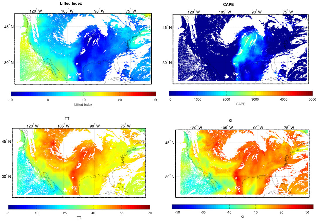 Examples of a number of the atmospheric stability products as generated by the GOES-R Temperature, Moisture, and Atmospheric Stability algorithm using simulated GOES-R data on 04 June 2005 22:00 UTC. Stability indices shown include Lifted Index (upper left), CAPE (upper right), Totals Total (lower left) and K-Index (lower right).
The GOES-R Advanced Baseline Imager (ABI) Derived Stability Indices product contains images for five stability indices with pixel values that are indicators of atmospheric instability associated with convection and potential thunderstorm activity. 1) Convective(ly) Available Potential Energy (CAPE): A measure of atmospheric stability calculated by integrating the positive temperature difference between the surrounding atmosphere and a parcel of air lifted adiabatically from the surface to its equilibrium level. It exists under conditions of potential instability, and measures the potential energy per unit mass that would be released by the unstable parcel if it were able to convect upwards to equilibrium. Units of measure are joules per kilogram. 2) Lifted Index: The temperature difference between a parcel of air lifted adiabatically from the surface to a finishing air pressure of 500 hPa in the troposphere and the ambient air temperature at the finishing air pressure in the troposphere. The air parcel is "lifted" by moving the air parcel from the surface to the Lifting Condensation Level (dry adiabatically) and then from the Lifting Condensation Level to the finishing air pressure (wet adiabatically). Units of measure are kelvin. 3) K-Index: A measure of atmospheric stability indicating the potential of severe convection. The index is the difference in air temperature between 850 and 500 hPa, the dew point temperature at 850 hPa, and the difference between the air temperature and the dew point temperature at 700 hPa. Units of measure are kelvin. 4) Showalter Index: A measure of atmospheric stability indicating the convective and thunderstorm potential. The index is the temperature difference between a parcel of air lifted from 850 to 500 hPa (wet adiabatically) and the ambient air temperature at 500 hPa. Units of measure are kelvin. 5) Total Totals Index: A measure of atmospheric stability indicating the likelihood of severe convection. The index is derived from the difference in air temperature between 850 and 500 hPa (the vertical totals) and the difference between the dew point temperature at 850 hPa and the air temperature at 500 hPa (the cross totals). The index is the sum of the vertical and cross totals. Units of measure are kelvin. The product includes three types of data quality information. One describes the overall quality of the data pixels, providing an assessment of the derived stability indices data values for on-earth pixels. The second provides information about the quality of the physical retrieval for on-earth pixels, identifying failure conditions. The third provides information about the quality of the first guess skin temperature for onearth pixels, identifying temperature threshold failure conditions for on-earth pixels. The Derived Stability Indices product images are produced on the ABI fixed grid at 10 km resolution for Full Disk, CONUS, and Mesoscale coverage regions from GOES East and West. Product data is produced under the following conditions: Clear sky; Geolocated source data to local zenith angles of 80 degrees for both daytime and nighttime conditions.
- Cite as: GOES-R Algorithm Working Group and GOES-R Series Program, (2018): NOAA GOES-R Series Advanced Baseline Imager (ABI) Level 2 Derived Stability Indices. [indicate subset used]. NOAA National Centers for Environmental information. doi:10.7289/V50Z71KF. [access date].
| Download Data |
|
| Order Data |
|
| Distribution Formats |
|
| Ordering Instructions |
Contact NCEI for other distribution options and instructions. |
| Distributor |
NOAA National Centers for Environmental Information
ncei.info@noaa.gov
|
| Dataset Point of Contact |
Customer Engagement Branch
DOC/NOAA/NESDIS/NCEI > National Centers for Environmental Information, NESDIS, NOAA, U.S. Department of Commerce
ncei.sat.info@noaa.gov
|
| Time Period |
2017-05-16 to Present (time interval: 10-minute) |
| Spatial Reference System |
urn:ogc:def:crs:EPSG::4326 |
| Spatial Bounding Box Coordinates |
West: -156.2995
East: 6.2995
South: -81.3282
North: 81.3282
West: 141.7005
East: -55.7005
South: -81.3282
North: 81.3282
|
| Spatial Coverage Map |
|
| General Documentation |
|
| Processing Documents |
- GOES-R Algorithm Working Group
-
GOES-R Algorithm Working Group
The GOES-R Algorithm Working Group creates the algorithms that process the quality controlled satellite instrument data and produces resulting data products.
- NOAA Satellite Information System Product Quality
- GOES-R Algorithm Theoretical Basis Documents
|
| Associated Resources |
- GOES-R Program Document Library
- GOES Operational Status - NOAA Office of Satellite and Product Operations
|
| Publication Dates |
|
| Edition |
Provisional |
| Data Presentation Form |
Digital image
|
| Dataset Progress Status |
Ongoing - data is continually being updated |
| Data Update Frequency |
Continual |
| Purpose |
The Derived Stability Indices such as Convective Available Potential Energy (CAPE), Lifted Index (LI), Totals Total (TT), Showalter Index (SI), and the K-Index (KI) will be computed from the retrieved atmospheric moisture and temperature profiles. These indices will aid forecasters in nowcasting severe weather by providing them with a plan view of these atmospheric stability parameters. Forecasters will use this information to monitor rapid changes in atmospheric stability over time at various geographic locations, thus improving their situational awareness in pre-convective environments for potential watch/warning scenarios. |
| Use Limitations |
- For a complete description of use limitations for this dataset, refer to the Algorithm Theoretical Basis Document (ATBD).
|
| Dataset Citation |
- Cite as: GOES-R Algorithm Working Group and GOES-R Series Program, (2018): NOAA GOES-R Series Advanced Baseline Imager (ABI) Level 2 Derived Stability Indices. [indicate subset used]. NOAA National Centers for Environmental information. doi:10.7289/V50Z71KF. [access date].
|
| Cited Authors |
- GOES-R Algorithm Working Group
- GOES-R Series Program
|
| Principal Investigators |
- GOES-R Algorithm Working Group
|
| Resource Providers |
|
| Publishers |
- NOAA National Centers for Environmental Information
|
| Theme keywords |
Global Change Master Directory (GCMD) Science Keywords
- Earth Science > Atmosphere > Weather Events > Stability/Severe Weather Indices > Convective Available Potential Energy (cape)
- Earth Science > Atmosphere > Weather Events > Stability/Severe Weather Indices > Total Totals Index (tt)
- Earth Science > Atmosphere > Weather Events > Stability/Severe Weather Indices > Showalter Stability Index (si)
- Earth Science > Atmosphere > Weather Events > Stability/Severe Weather Indices > K-Index (ki)
- Earth Science > Atmosphere > Weather Events > Stability/Severe Weather Indices > Lifted Index (li)
|
| Data Center keywords |
Global Change Master Directory (GCMD) Data Center Keywords
- DOC/NOAA/NESDIS/NCDC > National Climatic Data Center, NESDIS, NOAA, U.S. Department of Commerce
- DOC/NOAA/NESDIS/NCEI > National Centers for Environmental Information, NESDIS, NOAA, U.S. Department of Commerce
- DOC/NOAA/NESDIS/STAR > Center for Satellite Applications and Research, NESDIS, NOAA, U.S. Department of Commerce
- DOC/NOAA/NESDIS/OSPO > Office of Satellite and Product Operations, NESDIS, NOAA, U.S. Department of Commerce
|
| Platform keywords |
Global Change Master Directory (GCMD) Platform Keywords
- GOES-16 > Geostationary Operational Environmental Satellite 16
- GOES-17 > Geostationary Operational Environmental Satellite 17
- GOES-18 > Geostationary Operational Environmental Satellite 18
|
| Instrument keywords |
Global Change Master Directory (GCMD) Instrument Keywords- ABI > Advanced Baseline Imager
|
| Place keywords |
Global Change Master Directory (GCMD) Location Keywords
- Geographic Region > Equatorial
- Geographic Region > Mid-Latitude
- Geographic Region > Northern Hemisphere
- Geographic Region > Southern Hemisphere
- Geographic Region > Western Hemisphere
- Geographic Region > Tropics
- Continent > North America > United States Of America
- Continent > North America > Central America
- Continent > South America
- Ocean > Atlantic Ocean
- Ocean > Pacific Ocean
|
| Project keywords |
Global Change Master Directory (GCMD) Project Keywords
- GOES > Geostationary Operational Environmental Satellites
- ABI-L2-DSI
- gov.noaa.class:GRABIPRD
- GRABIPRD
|
| Data Resolution keywords |
Global Change Master Directory (GCMD) Horizontal Data Resolution Keywords- 10 km - < 50 km or approximately .09 degree - < .5 degree
|
| Stratum keywords |
Global Change Master Directory (GCMD) Location Keywords- Vertical Location > Troposphere
|
| Use Constraints |
- Cite as: GOES-R Algorithm Working Group and GOES-R Series Program, (2018): NOAA GOES-R Series Advanced Baseline Imager (ABI) Level 2 Derived Stability Indices. [indicate subset used]. NOAA National Centers for Environmental information. doi:10.7289/V50Z71KF. [access date].
- Use liability: NOAA and NCEI cannot provide any warranty as to the accuracy, reliability, or completeness of furnished data. Users assume responsibility to determine the usability of these data. The user is responsible for the results of any application of this data for other than its intended purpose.
|
| Access Constraints |
- Distribution liability: NOAA and NCEI make no warranty, expressed or implied, regarding these data, nor does the fact of distribution constitute such a warranty. NOAA and NCEI cannot assume liability for any damages caused by any errors or omissions in these data. If appropriate, NCEI can only certify that the data it distributes are an authentic copy of the records that were accepted for inclusion in the NCEI archives.
|
| Fees |
- In most cases, electronic downloads of the data are free. However, fees may apply for custom orders, data certifications, copies of analog materials, and data distribution on physical media.
|
| Lineage information for: dataset |
|---|
| Lineage Statement |
These data were produced by the NOAA Office of Satellite and Product Operations (OSPO) and are archived at the NOAA National Centers for Environmental Information (NCEI). |
| Processor |
- DOC/NOAA/NESDIS/OSPO > Office of Satellite and Product Operations, NESDIS, NOAA, U.S. Department of Commerce
|
| Processing Steps |
- The Legacy Vertical Temperature Profile, Legacy Vertical Moisture Profile, Total Precipitable Water, and Derived Stability Indices products are generated by the GOES-R ABI Legacy Atmospheric Profiles ground processing algorithm. The algorithm uses processed NWP model profile data as the first guess and employs a regression retrieval followed by an iterative physical retrieval that utilizes the ground system implementation of the Community Radiative Transfer Model (CRTM) to derive the final product data. The temperature and moisture profiles contain values at 101 standard pressure levels, of which only 54 temperature and 35 moisture pressure levels are actually populated in the retrieval. The 54 temperature levels are from approximately 103 hPa to approximately 1014 hPa. The 35 moisture levels are from 300 hPa to approximately 1014 hPa. The regression retrieval is applied for coverage regions corresponding to local zenith angles to 80 degrees but the physical retrieval is limited to local zenith angles to 67 degrees. The product is generated for 5 x 5 fields of regard from 2 km pixel inputs where the percentage of clear pixels satisfies a 20 percent threshold. Clear sky is determined using clear and probably clear pixels indicated in the temporally coincident intermediate 4-level cloud mask generated by the Cloud Mask algorithm. Total precipitable water from the surface to 300 hPa is derived from the retrieved moisture profile. In addition, the five atmospheric stability indices, CAPE, K-index, Lifted Index, Showalter Index, and Total Totals Index, are derived from the retrieved moisture and temperature profiles. Pixels in the product images with out of range values are assigned the minimum or maximum value in the valid range.
- 2017-05-16T20:30:00 - The GOES-16 ABI Derived Stability Indices algorithm reached beta maturity.
- 2018-02-28T00:00:00 - The GOES-16 ABI Derived Stability Indices algorithm reached provisional maturity.
- The GOES-16 ABI Derived Stability Indices algorithm reached full validation maturity.
- 2018-08-27T00:00:00 - The GOES-17 ABI Derived Stability Indices algorithm reached beta maturity.
- The GOES-17 ABI Derived Stability Indices algorithm reached provisional maturity.
- The GOES-17 ABI Derived Stability Indices algorithm reached full validation maturity.
|
| Processing Documents |
- GOES-R Algorithm Working Group
-
GOES-R Algorithm Working Group
The GOES-R Algorithm Working Group creates the algorithms that process the quality controlled satellite instrument data and produces resulting data products.
- NOAA Satellite Information System Product Quality
- GOES-R Algorithm Theoretical Basis Documents
|
| Source Datasets |
- NOAA GOES-R Series Advanced Baseline Imager (ABI) Level 1b Radiances
-
NCEI landing page for ABI-L1B-RAD
Source dataset landing page with general information and access links for the dataset.
- Description of Source: Level 1b radiances
- Temporal extent used: 2017-02-28 to Present
- Spatial extent used: N:81.3282 S:-81.3282 E:6.2995 W:-156.2995
|
| Lineage information for: repository |
|---|
| Processing Steps |
- 2015-04-22T00:00:00 - NOAA created the National Centers for Environmental Information (NCEI) by merging NOAA's National Climatic Data Center (NCDC), National Geophysical Data Center (NGDC), and National Oceanographic Data Center (NODC), including the National Coastal Data Development Center (NCDDC), per the Consolidated and Further Continuing Appropriations Act, 2015, Public Law 113-235. NCEI launched publicly on April 22, 2015.
|
Last Modified: 2023-09-18
For questions about the information on this page, please email:
ncei.info@noaa.gov