NOAA GOES-R Series Advanced Baseline Imager (ABI) Level 2 Derived Motion Winds (DMW)
ABI-L2-DMW; ABI-L2-DMWVM
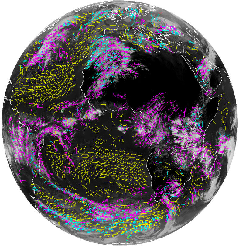 Example of the GOES-16 derived winds product.
The GOES-R Advanced Baseline Imager (ABI) Derived Motion Winds product contains a list of wind vectors identifying their location, wind speed, wind direction, air pressure and temperature, and local zenith angle. The product includes data quality information for each wind vector. The product name includes the word "derived" because the wind vectors are derived by tracking environmental features, specifically clouds and clear sky water vapor over multiple ABI observations. The type of feature tracked varies as a function of the ABI band. Derived Motion Wind product files are generated for the ABI reflective and emissive band that are used to track features. The units of measure for the wind vector quantities are meters per second for wind speed; degrees for wind direction; hectopascals for wind pressure; kelvin for air temperature. Product data is produced for geolocated source data to local zenith angles of 90 degrees. The Derived Motion Winds product is produced using ABI Full Disk, CONUS, and Mesoscale coverage region observations from GOES East and West.
- Cite as: GOES-R Algorithm Working Group and GOES-R Series Program, (2018): NOAA GOES-R Series Advanced Baseline Imager (ABI) Level 2 Derived Motion Winds (DMW). [indicate subset used]. NOAA National Centers for Environmental Information. doi:10.7289/V5X63K7V. [access date].
| Download Data |
|
| Order Data |
|
| Distribution Formats |
|
| Ordering Instructions |
Contact NCEI for other distribution options and instructions. |
| Distributor |
NOAA National Centers for Environmental Information
ncei.info@noaa.gov
|
| Dataset Point of Contact |
Customer Engagement Branch
DOC/NOAA/NESDIS/NCEI > National Centers for Environmental Information, NESDIS, NOAA, U.S. Department of Commerce
ncei.sat.info@noaa.gov
|
| Time Period |
2017-06-09 to Present (time interval: 10-minute) |
| Spatial Reference System |
urn:ogc:def:crs:EPSG::4326 |
| Spatial Bounding Box Coordinates |
West: -156.2995
East: 6.2995
South: -81.3282
North: 81.3282
West: 141.7005
East: -55.7005
South: -81.3282
North: 81.3282
|
| Spatial Coverage Map |
|
| General Documentation |
|
| Processing Documents |
- GOES-R Algorithm Working Group
-
GOES-R Algorithm Working Group
The GOES-R Algorithm Working Group creates the algorithms that process the quality controlled satellite instrument data and produces resulting data products.
- NOAA Satellite Information System Product Quality
- GOES-R Algorithm Theoretical Basis Documents
|
| Associated Resources |
- GOES-R Program Document Library
- GOES Operational Status - NOAA Office of Satellite and Product Operations
|
| Publication Dates |
|
| Edition |
Provisional |
| Data Presentation Form |
Digital image
|
| Dataset Progress Status |
Ongoing - data is continually being updated |
| Data Update Frequency |
Continual |
| Purpose |
The Derived Motion Winds product is derived from using a sequence of visible or IR spectral bands to track the motion of cloud features and water vapor gradients. The resulting estimates of atmospheric motion are assigned heights by using the Cloud Height product. The Derived Motion Wind product provides vital tropospheric wind information over expansive regions of the earth devoid of in-situ wind observations that include oceans and Southern Hemisphere land masses. This product provides key wind observations to operational NWP data assimilation systems where their use has been demonstrated to improved numerical weather prediction forecasts including tropical cyclones. In addition, this product provides improved guidance for NWS field forecasters. |
| Use Limitations |
- For a complete description of use limitations for this dataset, refer to the Algorithm Theoretical Basis Document (ATBD).
|
| Dataset Citation |
- Cite as: GOES-R Algorithm Working Group and GOES-R Series Program, (2018): NOAA GOES-R Series Advanced Baseline Imager (ABI) Level 2 Derived Motion Winds (DMW). [indicate subset used]. NOAA National Centers for Environmental Information. doi:10.7289/V5X63K7V. [access date].
|
| Cited Authors |
- GOES-R Algorithm Working Group
- GOES-R Series Program
|
| Principal Investigators |
- GOES-R Algorithm Working Group
|
| Resource Providers |
|
| Publishers |
- NOAA National Centers for Environmental Information
|
| Theme keywords |
Global Change Master Directory (GCMD) Science Keywords
- Earth Science > Atmosphere > Atmospheric Winds > Upper Level Winds > Wind Speed
- Earth Science > Atmosphere > Atmospheric Winds > Upper Level Winds > Wind Direction
- Earth Science > Atmosphere > Atmospheric Temperature > Upper Air Temperature
- Earth Science > Atmosphere > Clouds > Cloud Properties > Cloud Top Pressure >
Global Climate Observing System (GCOS) Essential Climate Variables (ECVs)- Atmospheric - Upper-air - Upper-air Wind Speed And Direction
|
| Data Center keywords |
Global Change Master Directory (GCMD) Data Center Keywords
- DOC/NOAA/NESDIS/NCDC > National Climatic Data Center, NESDIS, NOAA, U.S. Department of Commerce
- DOC/NOAA/NESDIS/NCEI > National Centers for Environmental Information, NESDIS, NOAA, U.S. Department of Commerce
- DOC/NOAA/NESDIS/STAR > Center for Satellite Applications and Research, NESDIS, NOAA, U.S. Department of Commerce
- DOC/NOAA/NESDIS/OSPO > Office of Satellite and Product Operations, NESDIS, NOAA, U.S. Department of Commerce
|
| Platform keywords |
Global Change Master Directory (GCMD) Platform Keywords
- GOES-16 > Geostationary Operational Environmental Satellite 16
- GOES-17 > Geostationary Operational Environmental Satellite 17
- GOES-18 > Geostationary Operational Environmental Satellite 18
|
| Instrument keywords |
Global Change Master Directory (GCMD) Instrument Keywords- ABI > Advanced Baseline Imager
|
| Place keywords |
Global Change Master Directory (GCMD) Location Keywords
- Geographic Region > Equatorial
- Geographic Region > Mid-Latitude
- Geographic Region > Northern Hemisphere
- Geographic Region > Southern Hemisphere
- Geographic Region > Western Hemisphere
- Geographic Region > Tropics
- Continent > North America > United States Of America
- Continent > North America > Central America
- Continent > South America
- Ocean > Atlantic Ocean
- Ocean > Pacific Ocean
|
| Project keywords |
Global Change Master Directory (GCMD) Project Keywords
- GOES > Geostationary Operational Environmental Satellites
- ABI-L2-DMW
- ABI-L2-DMWVM
- gov.noaa.class:GRABIPRD
- GRABIPRD
|
| Data Resolution keywords |
Global Change Master Directory (GCMD) Horizontal Data Resolution Keywords- 10 km - < 50 km or approximately .09 degree - < .5 degree
|
| Stratum keywords |
Global Change Master Directory (GCMD) Location Keywords- Vertical Location > Troposphere
|
| Use Constraints |
- Cite as: GOES-R Algorithm Working Group and GOES-R Series Program, (2018): NOAA GOES-R Series Advanced Baseline Imager (ABI) Level 2 Derived Motion Winds (DMW). [indicate subset used]. NOAA National Centers for Environmental Information. doi:10.7289/V5X63K7V. [access date].
- Use liability: NOAA and NCEI cannot provide any warranty as to the accuracy, reliability, or completeness of furnished data. Users assume responsibility to determine the usability of these data. The user is responsible for the results of any application of this data for other than its intended purpose.
|
| Access Constraints |
- Distribution liability: NOAA and NCEI make no warranty, expressed or implied, regarding these data, nor does the fact of distribution constitute such a warranty. NOAA and NCEI cannot assume liability for any damages caused by any errors or omissions in these data. If appropriate, NCEI can only certify that the data it distributes are an authentic copy of the records that were accepted for inclusion in the NCEI archives.
|
| Fees |
- In most cases, electronic downloads of the data are free. However, fees may apply for custom orders, data certifications, copies of analog materials, and data distribution on physical media.
|
| Lineage information for: dataset |
|---|
| Lineage Statement |
These data were produced by the NOAA Office of Satellite and Product Operations (OSPO) and are archived at the NOAA National Centers for Environmental Information (NCEI). |
| Processor |
- DOC/NOAA/NESDIS/OSPO > Office of Satellite and Product Operations, NESDIS, NOAA, U.S. Department of Commerce
|
| Processing Steps |
- The Derived Motion Winds product is generated by the GOES-R ABI Derived Motion Winds ground processing algorithm. Wind speed and direction are determined by tracking environmental features, specifically cloud edges and clear sky moisture gradients, over a time series composed of three ABI observations. Two displacement vectors are produced for the two time adjacent observation pairs, and then averaged. The time associated with wind vectors in a Derived Motion Winds product file is the acquisition time associated with the middle observation. The algorithm performs several consistency checks on the derived wind information including a comparison with the NWP wind forecast to establish a confidence level for the wind vector and an estimate of its wind speed error. For each ABI band, algorithm processing occurs independently and separate product files are generated. The configuration of each retrieval is band dependent and is determined by the target type (clear sky water vapor or cloud), target box size, search window size (i.e. lag size), temporal spacing between image pairs, and the application of nested tracking of target sub-regions. This configuration information is included in the product metadata. Product files include data for each attempted wind retrieval. It is possible that one or more wind vectors in a product file have one or more null values in its data elements, which is indicated with the applicable variables' fill values. When operating in ABI mode 3, there will be a delay in the production of mesoscale Derived Motion Wind product files when the ABI is commanded to observe a new mesoscale region. This is because the algorithm requires three successive product images. The amount of delay is approximately twice the required time between successive images, which is band-specific and managed as a parameter in the Level 2+ semi-static source data. The time between successive images value is included in the product.
- 2017-06-09T00:00:00 - The GOES-16 ABI Derived Motion Winds algorithm has reached beta maturity.
- 2018-02-08T00:00:00 - The GOES-16 ABI Derived Motion Winds algorithm has reached provisional maturity.
- The GOES-16 ABI Derived Motion Winds algorithm has reached full validation maturity.
- 2018-08-27T00:00:00 - The GOES-16 ABI Derived Motion Winds algorithm has reached beta maturity.
- The GOES-17 ABI Derived Motion Winds algorithm has reached provisional maturity.
- The GOES-17 ABI Derived Motion Winds algorithm has reached full validation maturity.
|
| Processing Documents |
- GOES-R Algorithm Working Group
-
GOES-R Algorithm Working Group
The GOES-R Algorithm Working Group creates the algorithms that process the quality controlled satellite instrument data and produces resulting data products.
- NOAA Satellite Information System Product Quality
- GOES-R Algorithm Theoretical Basis Documents
|
| Source Datasets |
- NOAA GOES-R Series Advanced Baseline Imager (ABI) Level 1b Radiances
-
NCEI landing page for ABI-L1B-RAD
Source dataset landing page with general information and access links for the dataset.
- Description of Source: Level 1b radiances
- Temporal extent used: 2017-02-28 to Present
- Spatial extent used: N:81.3282 S:-81.3282 E:6.2995 W:-156.2995
|
| Lineage information for: repository |
|---|
| Processing Steps |
- 2015-04-22T00:00:00 - NOAA created the National Centers for Environmental Information (NCEI) by merging NOAA's National Climatic Data Center (NCDC), National Geophysical Data Center (NGDC), and National Oceanographic Data Center (NODC), including the National Coastal Data Development Center (NCDDC), per the Consolidated and Further Continuing Appropriations Act, 2015, Public Law 113-235. NCEI launched publicly on April 22, 2015.
|
Last Modified: 2023-09-18
For questions about the information on this page, please email:
ncei.info@noaa.gov