NOAA GOES-R Series Advanced Baseline Imager (ABI) Level 2 Derived Motion Winds (DMW)
- referenceSystemInfo
- identificationInfo
- contentInfo
- distributionInfo
- dataQualityInfo
- dataQualityInfo
- metadataMaintenance
(MI_Metadata)
fileIdentifier: gov.noaa.ncdc:C01518
language: eng; USA
characterSet: (MD_CharacterSetCode) utf8
hierarchyLevel: (MD_ScopeCode) dataset
contact: (CI_ResponsibleParty)
organisationName: NOAA National Centers for Environmental Information
contactInfo: (CI_Contact)
address: (CI_Address)
electronicMailAddress: ncei.info@noaa.gov
onlineResource: (CI_OnlineResource)
linkage: https://www.ncei.noaa.gov/contact
name: NCEI Contact Information
description: Information for contacts at NCEI.
function: (CI_OnLineFunctionCode) information
role: (CI_RoleCode) pointOfContact
dateStamp: 2023-09-18
metadataStandardName: ISO 19115-2 Geographic Information - Metadata - Part 2: Extensions for Imagery and Gridded Data
metadataStandardVersion: ISO 19115-2:2009(E)
return to top
referenceSystemInfo: (MD_ReferenceSystem)
referenceSystemIdentifier: (RS_Identifier)
authority: (CI_Citation)
title: EPSG Geodetic Parameter Dataset Registry
date: (CI_Date)
date: 2008-11-12
dateType: (CI_DateTypeCode) publication
citedResponsibleParty: (CI_ResponsibleParty)
organisationName: International Association of Oil and Gas Producers (OGP) Geomatics Committee
contactInfo: (CI_Contact)
onlineResource: (CI_OnlineResource)
linkage: http://www.epsg-registry.org/
applicationProfile: Data Search Application
name: EPSG Geodetic Parameter Dataset Registry Application
description: Interface to the EPSG Geodetic Parameter Dataset Registry
function: (CI_OnLineFunctionCode) search
role: (CI_RoleCode) custodian
citedResponsibleParty: (CI_ResponsibleParty)
organisationName: International Association of Oil and Gas Producers (OGP) Geomatics Committee
contactInfo: (CI_Contact)
onlineResource: (CI_OnlineResource)
linkage: http://www.epsg-registry.org/export.htm?gml=urn:ogc:def:crs:EPSG::4326
applicationProfile: Download
name: Coordinate Reference System data in GML
description: Coordinate Reference System data in GML
function: (CI_OnLineFunctionCode) download
role: (CI_RoleCode) custodian
code: urn:ogc:def:crs:EPSG::4326
version: (unknown)
return to top
identificationInfo: (MD_DataIdentification)
citation: (CI_Citation)
title: NOAA GOES-R Series Advanced Baseline Imager (ABI) Level 2 Derived Motion Winds (DMW)
alternateTitle: ABI-L2-DMW
alternateTitle: ABI-L2-DMWVM
date: (CI_Date)
date: 2018-02-09
dateType: (CI_DateTypeCode) publication
edition: Provisional
identifier: (MD_Identifier)
code:
Anchor: DOI doi:10.7289/V5X63K7V
identifier: (MD_Identifier)
code: ABI-L2-DMW
identifier: (MD_Identifier)
code: ABI-L2-DMWVM
identifier: (MD_Identifier)
code: gov.noaa.ncdc:C01518
identifier: (MD_Identifier)
code: gov.noaa.class:GRABIPRD
citedResponsibleParty: (CI_ResponsibleParty)
organisationName: NOAA National Centers for Environmental Information
role: (CI_RoleCode) publisher
citedResponsibleParty: (CI_ResponsibleParty)
organisationName: GOES-R Algorithm Working Group
role: (CI_RoleCode) principalInvestigator
citedResponsibleParty: (CI_ResponsibleParty)
organisationName: GOES-R Algorithm Working Group
role: (CI_RoleCode) author
citedResponsibleParty: (CI_ResponsibleParty)
organisationName: GOES-R Series Program
role: (CI_RoleCode) resourceProvider
citedResponsibleParty: (CI_ResponsibleParty)
organisationName: GOES-R Series Program
role: (CI_RoleCode) author
presentationForm: (CI_PresentationFormCode) imageDigital
abstract: The GOES-R Advanced Baseline Imager (ABI) Derived Motion Winds product contains a list of wind vectors identifying their location, wind speed, wind direction, air pressure and temperature, and local zenith angle. The product includes data quality information for each wind vector. The product name includes the word "derived" because the wind vectors are derived by tracking environmental features, specifically clouds and clear sky water vapor over multiple ABI observations. The type of feature tracked varies as a function of the ABI band. Derived Motion Wind product files are generated for the ABI reflective and emissive band that are used to track features. The units of measure for the wind vector quantities are meters per second for wind speed; degrees for wind direction; hectopascals for wind pressure; kelvin for air temperature. Product data is produced for geolocated source data to local zenith angles of 90 degrees. The Derived Motion Winds product is produced using ABI Full Disk, CONUS, and Mesoscale coverage region observations from GOES East and West.
purpose: The Derived Motion Winds product is derived from using a sequence of visible or IR spectral bands to track the motion of cloud features and water vapor gradients. The resulting estimates of atmospheric motion are assigned heights by using the Cloud Height product. The Derived Motion Wind product provides vital tropospheric wind information over expansive regions of the earth devoid of in-situ wind observations that include oceans and Southern Hemisphere land masses. This product provides key wind observations to operational NWP data assimilation systems where their use has been demonstrated to improved numerical weather prediction forecasts including tropical cyclones. In addition, this product provides improved guidance for NWS field forecasters.
status: (MD_ProgressCode) onGoing
pointOfContact: (CI_ResponsibleParty)
individualName: Customer Engagement Branch
organisationName: DOC/NOAA/NESDIS/NCEI > National Centers for Environmental Information, NESDIS, NOAA, U.S. Department of Commerce
contactInfo: (CI_Contact)
address: (CI_Address)
electronicMailAddress: ncei.sat.info@noaa.gov
role: (CI_RoleCode) pointOfContact
resourceMaintenance: (MD_MaintenanceInformation)
maintenanceAndUpdateFrequency: (MD_MaintenanceFrequencyCode) continual
graphicOverview: (MD_BrowseGraphic)
fileName: https://www.ncei.noaa.gov/pub/data/metadata/images/C01518.jpg
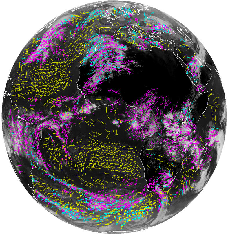
fileDescription: Example of the GOES-16 derived winds product.
fileType: JPEG
descriptiveKeywords: (MD_Keywords)
keyword: Earth Science > Atmosphere > Atmospheric Winds > Upper Level Winds > Wind Speed
keyword: Earth Science > Atmosphere > Atmospheric Winds > Upper Level Winds > Wind Direction
keyword: Earth Science > Atmosphere > Atmospheric Temperature > Upper Air Temperature
keyword: Earth Science > Atmosphere > Clouds > Cloud Properties > Cloud Top Pressure >
type: (MD_KeywordTypeCode) theme
thesaurusName: (CI_Citation)
title: Global Change Master Directory (GCMD) Science Keywords
date: (CI_Date)
date: 2018
dateType: (CI_DateTypeCode) revision
edition: Version 8.6
citedResponsibleParty: (CI_ResponsibleParty)
organisationName: Global Change Data Center, Science and Exploration Directorate, Goddard Space Flight Center (GSFC) National Aeronautics and Space Administration (NASA)
contactInfo: (CI_Contact)
onlineResource: (CI_OnlineResource)
linkage: https://earthdata.nasa.gov/about/gcmd/global-change-master-directory-gcmd-keywords
protocol: HTTPS
applicationProfile: Web Browser
name: Global Change Master Directory (GCMD) Keywords
description: The information provided on this page seeks to define how the GCMD Keywords are structured, used and accessed. It also provides information on how users can participate in the further development of the keywords.
function: (CI_OnLineFunctionCode) information
role: (CI_RoleCode) publisher
descriptiveKeywords: (MD_Keywords)
keyword: Atmospheric - Upper-air - Upper-air Wind Speed And Direction
type: (MD_KeywordTypeCode) theme
thesaurusName: (CI_Citation)
title: Global Climate Observing System (GCOS) Essential Climate Variables (ECVs)
date: (CI_Date)
date: 2017
dateType: (CI_DateTypeCode) publication
edition: Release 2017
citedResponsibleParty: (CI_ResponsibleParty)
organisationName: World Meteorological Organization, United Nations
contactInfo: (CI_Contact)
onlineResource: (CI_OnlineResource)
linkage: https://public.wmo.int/en/programmes/global-climate-observing-system/essential-climate-variables
protocol: HTTP
applicationProfile: Information
name: GCOS Essential Climate Variables
description: Overview of the GCOS Essential Climate Variables.
function: (CI_OnLineFunctionCode) information
role: (CI_RoleCode) custodian
descriptiveKeywords: (MD_Keywords)
keyword: Geographic Region > Equatorial
keyword: Geographic Region > Mid-Latitude
keyword: Geographic Region > Northern Hemisphere
keyword: Geographic Region > Southern Hemisphere
keyword: Geographic Region > Western Hemisphere
keyword: Geographic Region > Tropics
keyword: Continent > North America > United States Of America
keyword: Continent > North America > Central America
keyword: Continent > South America
keyword: Ocean > Atlantic Ocean
keyword: Ocean > Pacific Ocean
type: (MD_KeywordTypeCode) place
thesaurusName: (CI_Citation)
title: Global Change Master Directory (GCMD) Location Keywords
date: (CI_Date)
date: 2018
dateType: (CI_DateTypeCode) revision
edition: Version 8.6
citedResponsibleParty: (CI_ResponsibleParty)
organisationName: Global Change Data Center, Science and Exploration Directorate, Goddard Space Flight Center (GSFC) National Aeronautics and Space Administration (NASA)
contactInfo: (CI_Contact)
onlineResource: (CI_OnlineResource)
linkage: https://earthdata.nasa.gov/about/gcmd/global-change-master-directory-gcmd-keywords
protocol: HTTPS
applicationProfile: Web Browser
name: Global Change Master Directory (GCMD) Keywords
description: The information provided on this page seeks to define how the GCMD Keywords are structured, used and accessed. It also provides information on how users can participate in the further development of the keywords.
function: (CI_OnLineFunctionCode) information
role: (CI_RoleCode) publisher
descriptiveKeywords: (MD_Keywords)
keyword: Vertical Location > Troposphere
type: (MD_KeywordTypeCode) stratum
thesaurusName: (CI_Citation)
title: Global Change Master Directory (GCMD) Location Keywords
date: (CI_Date)
date: 2018
dateType: (CI_DateTypeCode) revision
edition: Version 8.6
citedResponsibleParty: (CI_ResponsibleParty)
organisationName: Global Change Data Center, Science and Exploration Directorate, Goddard Space Flight Center (GSFC) National Aeronautics and Space Administration (NASA)
contactInfo: (CI_Contact)
onlineResource: (CI_OnlineResource)
linkage: https://earthdata.nasa.gov/about/gcmd/global-change-master-directory-gcmd-keywords
protocol: HTTPS
applicationProfile: Web Browser
name: Global Change Master Directory (GCMD) Keywords
description: The information provided on this page seeks to define how the GCMD Keywords are structured, used and accessed. It also provides information on how users can participate in the further development of the keywords.
function: (CI_OnLineFunctionCode) information
role: (CI_RoleCode) publisher
descriptiveKeywords: (MD_Keywords)
keyword: GOES > Geostationary Operational Environmental Satellites
keyword: ABI-L2-DMW
keyword: ABI-L2-DMWVM
keyword: gov.noaa.class:GRABIPRD
keyword: GRABIPRD
type: (MD_KeywordTypeCode) project
thesaurusName: (CI_Citation)
title: Global Change Master Directory (GCMD) Project Keywords
date: (CI_Date)
date: 2018
dateType: (CI_DateTypeCode) revision
edition: Version 8.6
citedResponsibleParty: (CI_ResponsibleParty)
organisationName: Global Change Data Center, Science and Exploration Directorate, Goddard Space Flight Center (GSFC) National Aeronautics and Space Administration (NASA)
contactInfo: (CI_Contact)
onlineResource: (CI_OnlineResource)
linkage: https://earthdata.nasa.gov/about/gcmd/global-change-master-directory-gcmd-keywords
protocol: HTTPS
applicationProfile: Web Browser
name: Global Change Master Directory (GCMD) Keywords
description: The information provided on this page seeks to define how the GCMD Keywords are structured, used and accessed. It also provides information on how users can participate in the further development of the keywords.
function: (CI_OnLineFunctionCode) information
role: (CI_RoleCode) publisher
descriptiveKeywords: (MD_Keywords)
keyword: ABI > Advanced Baseline Imager
type: (MD_KeywordTypeCode) instrument
thesaurusName: (CI_Citation)
title: Global Change Master Directory (GCMD) Instrument Keywords
date: (CI_Date)
date: 2018
dateType: (CI_DateTypeCode) revision
edition: Version 8.6
citedResponsibleParty: (CI_ResponsibleParty)
organisationName: Global Change Data Center, Science and Exploration Directorate, Goddard Space Flight Center (GSFC) National Aeronautics and Space Administration (NASA)
contactInfo: (CI_Contact)
onlineResource: (CI_OnlineResource)
linkage: https://earthdata.nasa.gov/about/gcmd/global-change-master-directory-gcmd-keywords
protocol: HTTPS
applicationProfile: Web Browser
name: Global Change Master Directory (GCMD) Keywords
description: The information provided on this page seeks to define how the GCMD Keywords are structured, used and accessed. It also provides information on how users can participate in the further development of the keywords.
function: (CI_OnLineFunctionCode) information
role: (CI_RoleCode) publisher
descriptiveKeywords: (MD_Keywords)
keyword: GOES-16 > Geostationary Operational Environmental Satellite 16
keyword: GOES-17 > Geostationary Operational Environmental Satellite 17
keyword: GOES-18 > Geostationary Operational Environmental Satellite 18
type: (MD_KeywordTypeCode) platform
thesaurusName: (CI_Citation)
title: Global Change Master Directory (GCMD) Platform Keywords
date: (CI_Date)
date: 2018
dateType: (CI_DateTypeCode) revision
edition: Version 8.6
citedResponsibleParty: (CI_ResponsibleParty)
organisationName: Global Change Data Center, Science and Exploration Directorate, Goddard Space Flight Center (GSFC) National Aeronautics and Space Administration (NASA)
contactInfo: (CI_Contact)
onlineResource: (CI_OnlineResource)
linkage: https://earthdata.nasa.gov/about/gcmd/global-change-master-directory-gcmd-keywords
protocol: HTTPS
applicationProfile: Web Browser
name: Global Change Master Directory (GCMD) Keywords
description: The information provided on this page seeks to define how the GCMD Keywords are structured, used and accessed. It also provides information on how users can participate in the further development of the keywords.
function: (CI_OnLineFunctionCode) information
role: (CI_RoleCode) publisher
descriptiveKeywords: (MD_Keywords)
keyword: 10 km - < 50 km or approximately .09 degree - < .5 degree
type: (MD_KeywordTypeCode) dataResolution
thesaurusName: (CI_Citation)
title: Global Change Master Directory (GCMD) Horizontal Data Resolution Keywords
date: (CI_Date)
date: 2018
dateType: (CI_DateTypeCode) revision
edition: Version 8.6
citedResponsibleParty: (CI_ResponsibleParty)
organisationName: Global Change Data Center, Science and Exploration Directorate, Goddard Space Flight Center (GSFC) National Aeronautics and Space Administration (NASA)
contactInfo: (CI_Contact)
onlineResource: (CI_OnlineResource)
linkage: https://earthdata.nasa.gov/about/gcmd/global-change-master-directory-gcmd-keywords
protocol: HTTPS
applicationProfile: Web Browser
name: Global Change Master Directory (GCMD) Keywords
description: The information provided on this page seeks to define how the GCMD Keywords are structured, used and accessed. It also provides information on how users can participate in the further development of the keywords.
function: (CI_OnLineFunctionCode) information
role: (CI_RoleCode) publisher
descriptiveKeywords: (MD_Keywords)
keyword: DOC/NOAA/NESDIS/NCDC > National Climatic Data Center, NESDIS, NOAA, U.S. Department of Commerce
keyword: DOC/NOAA/NESDIS/NCEI > National Centers for Environmental Information, NESDIS, NOAA, U.S. Department of Commerce
keyword: DOC/NOAA/NESDIS/STAR > Center for Satellite Applications and Research, NESDIS, NOAA, U.S. Department of Commerce
keyword: DOC/NOAA/NESDIS/OSPO > Office of Satellite and Product Operations, NESDIS, NOAA, U.S. Department of Commerce
type: (MD_KeywordTypeCode) dataCentre
thesaurusName: (CI_Citation)
title: Global Change Master Directory (GCMD) Data Center Keywords
date: (CI_Date)
date: 2018
dateType: (CI_DateTypeCode) revision
edition: Version 8.6
citedResponsibleParty: (CI_ResponsibleParty)
organisationName: Global Change Data Center, Science and Exploration Directorate, Goddard Space Flight Center (GSFC) National Aeronautics and Space Administration (NASA)
contactInfo: (CI_Contact)
onlineResource: (CI_OnlineResource)
linkage: https://earthdata.nasa.gov/about/gcmd/global-change-master-directory-gcmd-keywords
protocol: HTTPS
applicationProfile: Web Browser
name: Global Change Master Directory (GCMD) Keywords
description: The information provided on this page seeks to define how the GCMD Keywords are structured, used and accessed. It also provides information on how users can participate in the further development of the keywords.
function: (CI_OnLineFunctionCode) information
role: (CI_RoleCode) publisher
descriptiveKeywords: (MD_Keywords)
keyword: gov.noaa.class:GRABIPRD
type: (MD_KeywordTypeCode) project
resourceConstraints: (MD_Constraints)
useLimitation: For a complete description of use limitations for this dataset, refer to the Algorithm Theoretical Basis Document (ATBD).
resourceConstraints: (MD_LegalConstraints)
useConstraints: (MD_RestrictionCode) otherRestrictions
otherConstraints: Cite as: GOES-R Algorithm Working Group and GOES-R Series Program, (2018): NOAA GOES-R Series Advanced Baseline Imager (ABI) Level 2 Derived Motion Winds (DMW). [indicate subset used]. NOAA National Centers for Environmental Information. doi:10.7289/V5X63K7V. [access date].
resourceConstraints: (MD_LegalConstraints)
accessConstraints: (MD_RestrictionCode) otherRestrictions
otherConstraints: Distribution liability: NOAA and NCEI make no warranty, expressed or implied, regarding these data, nor does the fact of distribution constitute such a warranty. NOAA and NCEI cannot assume liability for any damages caused by any errors or omissions in these data. If appropriate, NCEI can only certify that the data it distributes are an authentic copy of the records that were accepted for inclusion in the NCEI archives.
resourceConstraints: (MD_LegalConstraints)
useConstraints: (MD_RestrictionCode) otherRestrictions
otherConstraints: Use liability: NOAA and NCEI cannot provide any warranty as to the accuracy, reliability, or completeness of furnished data. Users assume responsibility to determine the usability of these data. The user is responsible for the results of any application of this data for other than its intended purpose.
aggregationInfo: (MD_AggregateInformation)
aggregateDataSetName: (CI_Citation)
title: GOES-R Program Document Library
date: (missing)
citedResponsibleParty: (CI_ResponsibleParty)
organisationName: (missing)
contactInfo: (CI_Contact)
onlineResource: (CI_OnlineResource)
linkage: https://www.goes-r.gov/resources/docs.html
applicationProfile: Web Browser
name: GOES-R Program Document Library
description: Webpage with product algorithm, users guides, and education and outreach materials.
function: (CI_OnLineFunctionCode) information
role: (missing)
associationType: (DS_AssociationTypeCode) crossReference
initiativeType: (DS_InitiativeTypeCode) userGuide
aggregationInfo: (MD_AggregateInformation)
aggregateDataSetName: (CI_Citation)
title: GOES Operational Status - NOAA Office of Satellite and Product Operations
date: (missing)
citedResponsibleParty: (CI_ResponsibleParty)
organisationName: (missing)
contactInfo: (CI_Contact)
onlineResource: (CI_OnlineResource)
linkage: https://www.ospo.noaa.gov/Operations/GOES/status.html
applicationProfile: Web Browser
name: GOES Operational Status - NOAA Office of Satellite and Product Operations
description: GOES spacecraft status page.
function: (CI_OnLineFunctionCode) information
role: (missing)
associationType: (DS_AssociationTypeCode) crossReference
initiativeType: (DS_InitiativeTypeCode) userGuide
spatialRepresentationType: (MD_SpatialRepresentationTypeCode) grid
spatialResolution: (MD_Resolution)
distance:
Distance: 38000
language: eng; USA
topicCategory: (MD_TopicCategoryCode) climatologyMeteorologyAtmosphere
extent: (EX_Extent)
geographicElement: (EX_GeographicBoundingBox)
extentTypeCode: 1
westBoundLongitude: -156.2995
eastBoundLongitude: 6.2995
southBoundLatitude: -81.3282
northBoundLatitude: 81.3282
geographicElement: (EX_GeographicBoundingBox)
extentTypeCode: 1
westBoundLongitude: 141.7005
eastBoundLongitude: -55.7005
southBoundLatitude: -81.3282
northBoundLatitude: 81.3282
temporalElement: (EX_TemporalExtent)
extent:
TimePeriod:
description: ground condition
beginPosition: 2017-06-09
endPosition:
timeInterval: 10
return to top
contentInfo: (MI_CoverageDescription)
attributeDescription:
RecordType: OR_ABI-L2-DMWC-ModeChannel_G16_sYYYYDDDHHMMSS_eYYYYDDDHHMMSS_cYYYYDDDHHMMSS.nc
contentType: (MD_CoverageContentTypeCode) physicalMeasurement
dimension: (MD_Band)
sequenceIdentifier:
MemberName:
aName: lat
attributeType:
TypeName:
aName: double
descriptor: ABI L2+ Derived Motion Winds: wind vector's latitude coordinate (latitude)
units: http://example.org/someUnitsDictionary.xml#degrees_north
dimension: (MD_Band)
sequenceIdentifier:
MemberName:
aName: lon
attributeType:
TypeName:
aName: double
descriptor: ABI L2+ Derived Motion Winds: wind vector's longitude coordinate (longitude)
units: http://example.org/someUnitsDictionary.xml#degrees_east
dimension: (MD_Band)
sequenceIdentifier:
MemberName:
aName: time
attributeType:
TypeName:
aName: double
descriptor: J2000 epoch mid-point between the start and end image scan in seconds (time)
units: http://example.org/someUnitsDictionary.xml#seconds%20since%202000-01-01%2012%3A00%3A00
dimension: (MD_Band)
sequenceIdentifier:
MemberName:
aName: wind_speed
attributeType:
TypeName:
aName: float
descriptor: ABI L2+ Derived Motion Winds: wind vector's wind speed (wind_speed)
units: http://example.org/someUnitsDictionary.xml#m%20s-1
dimension: (MD_Band)
sequenceIdentifier:
MemberName:
aName: wind_direction
attributeType:
TypeName:
aName: float
descriptor: ABI L2+ Derived Motion Winds: wind vector's wind from direction measured positive clockwise from due north (wind_from_direction)
units: http://example.org/someUnitsDictionary.xml#degree
dimension: (MD_Band)
sequenceIdentifier:
MemberName:
aName: pressure
attributeType:
TypeName:
aName: float
descriptor: ABI L2+ Derived Motion Winds: wind vector's air pressure (air_pressure)
units: http://example.org/someUnitsDictionary.xml#hPa
dimension: (MD_Band)
sequenceIdentifier:
MemberName:
aName: temperature
attributeType:
TypeName:
aName: float
descriptor: ABI L2+ Derived Motion Winds: wind vector's air temperature (air_temperature)
units: http://example.org/someUnitsDictionary.xml#K
dimension: (MD_Band)
sequenceIdentifier:
MemberName:
aName: local_zenith_angle
attributeType:
TypeName:
aName: float
descriptor: ABI L2+ Derived Motion Winds: wind vector's local zenith angle (platform_zenith_angle)
units: http://example.org/someUnitsDictionary.xml#degree
dimension: (MD_Band)
sequenceIdentifier:
MemberName:
aName: DQF
attributeType:
TypeName:
aName: byte
descriptor: ABI L2+ Derived Motion Winds data quality flags (status_flag)
units: http://example.org/someUnitsDictionary.xml#1
dimension: (MD_Band)
sequenceIdentifier:
MemberName:
aName: lat_image
attributeType:
TypeName:
aName: float
descriptor: latitude coordinate for center of image (latitude)
units: http://example.org/someUnitsDictionary.xml#degrees_north
dimension: (MD_Band)
sequenceIdentifier:
MemberName:
aName: lat_image_bounds
attributeType:
TypeName:
aName: float
descriptor: latitude coordinates for north/south extent of image
dimension: (MD_Band)
sequenceIdentifier:
MemberName:
aName: lon_image
attributeType:
TypeName:
aName: float
descriptor: longitude coordinate for center of image (longitude)
units: http://example.org/someUnitsDictionary.xml#degrees_east
dimension: (MD_Band)
sequenceIdentifier:
MemberName:
aName: lon_image_bounds
attributeType:
TypeName:
aName: float
descriptor: longitude coordinates for west/east extent of image
dimension: (MD_Band)
sequenceIdentifier:
MemberName:
aName: goes_lat_lon_projection
attributeType:
TypeName:
aName: int
descriptor: GOES-R latitude / longitude projection
dimension: (MD_Band)
sequenceIdentifier:
MemberName:
aName: nominal_satellite_subpoint_lat
attributeType:
TypeName:
aName: float
descriptor: nominal satellite subpoint latitude (platform latitude) (latitude)
units: http://example.org/someUnitsDictionary.xml#degrees_north
dimension: (MD_Band)
sequenceIdentifier:
MemberName:
aName: nominal_satellite_subpoint_lon
attributeType:
TypeName:
aName: float
descriptor: nominal satellite subpoint longitude (platform longitude) (longitude)
units: http://example.org/someUnitsDictionary.xml#degrees_east
dimension: (MD_Band)
sequenceIdentifier:
MemberName:
aName: nominal_satellite_height
attributeType:
TypeName:
aName: float
descriptor: nominal satellite height above GRS 80 ellipsoid (platform altitude) (height_above_reference_ellipsoid)
units: http://example.org/someUnitsDictionary.xml#km
dimension: (MD_Band)
sequenceIdentifier:
MemberName:
aName: geospatial_lat_lon_extent
attributeType:
TypeName:
aName: float
descriptor: geospatial latitude and longitude references
dimension: (MD_Band)
sequenceIdentifier:
MemberName:
aName: seconds_between_images
attributeType:
TypeName:
aName: int
descriptor: number of seconds between successive images used to derive wind vectors
units: http://example.org/someUnitsDictionary.xml#s
dimension: (MD_Band)
sequenceIdentifier:
MemberName:
aName: time_bounds
attributeType:
TypeName:
aName: double
descriptor: scan start and end times in seconds since epoch (2000-01-01 12:00:00)
dimension: (MD_Band)
sequenceIdentifier:
MemberName:
aName: retrieval_local_zenith_angle
attributeType:
TypeName:
aName: float
descriptor: threshold angle between the line of sight to the satellite and the local zenith at the observation target for good quality derived motion winds data production (platform_zenith_angle)
units: http://example.org/someUnitsDictionary.xml#degree
dimension: (MD_Band)
sequenceIdentifier:
MemberName:
aName: retrieval_local_zenith_angle_bounds
attributeType:
TypeName:
aName: float
descriptor: local zenith angle degree range where good quality derived motion winds data is produced
dimension: (MD_Band)
sequenceIdentifier:
MemberName:
aName: atmospheric_layer_pressure
attributeType:
TypeName:
aName: float
descriptor: central pressure level in atmospheric layer for related reported derived motion wind statistics (air_pressure)
units: http://example.org/someUnitsDictionary.xml#hPa
dimension: (MD_Band)
sequenceIdentifier:
MemberName:
aName: atmospheric_layer_pressure_bounds
attributeType:
TypeName:
aName: float
descriptor: pressure range for each atmospheric layer for related reported derived motion wind statistics
dimension: (MD_Band)
sequenceIdentifier:
MemberName:
aName: wind_speed_outlier_count
attributeType:
TypeName:
aName: int
descriptor: number of wind vector's wind speed whose value is outside valid measurement range
units: http://example.org/someUnitsDictionary.xml#count
dimension: (MD_Band)
sequenceIdentifier:
MemberName:
aName: number_of_wind_vectors_in_atmospheric_layer
attributeType:
TypeName:
aName: int
descriptor: number of good quality wind vectors in atmospheric layer
units: http://example.org/someUnitsDictionary.xml#count
dimension: (MD_Band)
sequenceIdentifier:
MemberName:
aName: target_box_size
attributeType:
TypeName:
aName: int
descriptor: row and column dimension in pixels of the target box scene used to locate targets in image
units: http://example.org/someUnitsDictionary.xml#count
dimension: (MD_Band)
sequenceIdentifier:
MemberName:
aName: lag_size
attributeType:
TypeName:
aName: int
descriptor: maximum displacement in pixels of target box scene used to locate targets in image within search area. numerically, absolute value of lag_size-1 is maximum displacement in pixels for a target at center of search box
units: http://example.org/someUnitsDictionary.xml#count
dimension: (MD_Band)
sequenceIdentifier:
MemberName:
aName: nested_tracking_flag
attributeType:
TypeName:
aName: int
descriptor: binary flag indicating the enabling of nested tracking of sub-scenes within the target box scene, which is used to determine the dominant motion of features in image
units: http://example.org/someUnitsDictionary.xml#1
dimension: (MD_Band)
sequenceIdentifier:
MemberName:
aName: target_type
attributeType:
TypeName:
aName: int
descriptor: binary flag indicating whether wind vectors are derived from clear-sky (i.e water vapor) or cloud targets
units: http://example.org/someUnitsDictionary.xml#1
dimension: (MD_Band)
sequenceIdentifier:
MemberName:
aName: minimum_wind_speed
attributeType:
TypeName:
aName: float
descriptor: minimum wind speed (wind_speed)
units: http://example.org/someUnitsDictionary.xml#m%20s-1
dimension: (MD_Band)
sequenceIdentifier:
MemberName:
aName: maximum_wind_speed
attributeType:
TypeName:
aName: float
descriptor: maximum wind speed (wind_speed)
units: http://example.org/someUnitsDictionary.xml#m%20s-1
dimension: (MD_Band)
sequenceIdentifier:
MemberName:
aName: mean_wind_speed
attributeType:
TypeName:
aName: float
descriptor: mean wind speed (wind_speed)
units: http://example.org/someUnitsDictionary.xml#m%20s-1
dimension: (MD_Band)
sequenceIdentifier:
MemberName:
aName: standard_deviation_wind_speed
attributeType:
TypeName:
aName: float
descriptor: standard deviation of wind speed values (wind_speed)
units: http://example.org/someUnitsDictionary.xml#m%20s-1
dimension: (MD_Band)
sequenceIdentifier:
MemberName:
aName: min_cloud_top_pressure_in_atmospheric_layer
attributeType:
TypeName:
aName: float
descriptor: minimum cloud top pressure in atmospheric layer associated with the derivation of wind vectors (air_pressure_at_cloud_top)
units: http://example.org/someUnitsDictionary.xml#hPa
dimension: (MD_Band)
sequenceIdentifier:
MemberName:
aName: max_cloud_top_pressure_in_atmospheric_layer
attributeType:
TypeName:
aName: float
descriptor: maximum cloud top pressure in atmospheric layer associated with the derivation of wind vectors (air_pressure_at_cloud_top)
units: http://example.org/someUnitsDictionary.xml#hPa
dimension: (MD_Band)
sequenceIdentifier:
MemberName:
aName: mean_cloud_top_pressure_in_atmospheric_layer
attributeType:
TypeName:
aName: float
descriptor: mean cloud top pressure in atmospheric layer associated with the derivation of wind vectors (air_pressure_at_cloud_top)
units: http://example.org/someUnitsDictionary.xml#hPa
dimension: (MD_Band)
sequenceIdentifier:
MemberName:
aName: standard_deviation_cloud_top_pressure_in_atmospheric_layer
attributeType:
TypeName:
aName: float
descriptor: standard deviation of cloud top pressure values in atmospheric layer associated with the derivation of wind vectors (air_pressure_at_cloud_top)
units: http://example.org/someUnitsDictionary.xml#hPa
dimension: (MD_Band)
sequenceIdentifier:
MemberName:
aName: percent_uncorrectable_GRB_errors
attributeType:
TypeName:
aName: float
descriptor: percent data lost due to uncorrectable GRB errors
units: http://example.org/someUnitsDictionary.xml#percent
dimension: (MD_Band)
sequenceIdentifier:
MemberName:
aName: percent_uncorrectable_L0_errors
attributeType:
TypeName:
aName: float
descriptor: percent data lost due to uncorrectable L0 errors
units: http://example.org/someUnitsDictionary.xml#percent
dimension: (MD_Band)
sequenceIdentifier:
MemberName:
aName: algorithm_dynamic_input_data_container
attributeType:
TypeName:
aName: int
descriptor: container for filenames of dynamic algorithm input data
dimension: (MD_Band)
sequenceIdentifier:
MemberName:
aName: processing_parm_version_container
attributeType:
TypeName:
aName: int
descriptor: container for processing parameter filenames
dimension: (MD_Band)
sequenceIdentifier:
MemberName:
aName: algorithm_product_version_container
attributeType:
TypeName:
aName: int
descriptor: container for algorithm package filename and product version
dimension: (MD_Band)
sequenceIdentifier:
MemberName:
aName: band_id
attributeType:
TypeName:
aName: byte
descriptor: ABI band identifier for this derived motion winds product file's data (sensor_band_identifier)
units: http://example.org/someUnitsDictionary.xml#1
dimension: (MD_Band)
sequenceIdentifier:
MemberName:
aName: band_wavelength
attributeType:
TypeName:
aName: float
descriptor: ABI band central wavelength for this derived motion winds product file's data (sensor_band_central_radiation_wavelength)
units: http://example.org/someUnitsDictionary.xml#um
dimension: (MD_Band)
sequenceIdentifier:
MemberName:
aName: solar_zenith_angle
attributeType:
TypeName:
aName: float
descriptor: threshold angle between the line of sight to the sun and the local zenith at the observation target for good quality derived motion winds data production (solar_zenith_angle)
units: http://example.org/someUnitsDictionary.xml#degree
dimension: (MD_Band)
sequenceIdentifier:
MemberName:
aName: solar_zenith_angle_bounds
attributeType:
TypeName:
aName: float
descriptor: solar zenith angle degree range where good quality derived motion winds data is produced
return to top
distributionInfo: (MD_Distribution)
distributor: (MD_Distributor)
distributorContact: (CI_ResponsibleParty)
organisationName: NOAA National Centers for Environmental Information
contactInfo: (CI_Contact)
address: (CI_Address)
electronicMailAddress: ncei.info@noaa.gov
onlineResource: (CI_OnlineResource)
linkage: https://www.ncei.noaa.gov/contact
name: NCEI Contact Information
description: Information for contacts at NCEI.
function: (CI_OnLineFunctionCode) information
role: (CI_RoleCode) distributor
distributionOrderProcess: (MD_StandardOrderProcess)
fees: In most cases, electronic downloads of the data are free. However, fees may apply for custom orders, data certifications, copies of analog materials, and data distribution on physical media.
orderingInstructions: Contact NCEI for other distribution options and instructions.
distributorFormat: (MD_Format)
name: NetCDF
version: 4
distributorTransferOptions: (MD_DigitalTransferOptions)
onLine: (CI_OnlineResource)
linkage: https://doi.org/10.7289/V5X63K7V
protocol: HTTPS
applicationProfile: Landing Page
name: NCEI Dataset Landing Page
description: Landing page for the dataset.
function: (CI_OnLineFunctionCode) information
distributorTransferOptions: (MD_DigitalTransferOptions)
onLine: (CI_OnlineResource)
linkage: https://www.ncdc.noaa.gov/airs-web/search
protocol: HTTPS
applicationProfile: Data Search Application
name: NCEI Archive Information Request System
description: Search the data archive and submit an order for the dataset via the interface.
function: (CI_OnLineFunctionCode) order
distributorTransferOptions: (MD_DigitalTransferOptions)
onLine: (CI_OnlineResource)
linkage: http://www.class.noaa.gov/saa/products/search?datatype_family=GRABIPRD
protocol: HTTPS
applicationProfile: Data Search Application
name: NOAA CLASS Data Search and Order
description: Search the data archive and submit an order for the dataset via the interface.
function: (CI_OnLineFunctionCode) order
distributorTransferOptions: (MD_DigitalTransferOptions)
onLine: (CI_OnlineResource)
linkage: https://www.ncei.noaa.gov/products/goes-terrestrial-weather-abi-glm
protocol: HTTPS
applicationProfile: Information
name: NCEI GOES-R Terrestrial Weather (ABI/GLM)
description: Description of the products and related resources.
function: (CI_OnLineFunctionCode) information
distributorTransferOptions: (MD_DigitalTransferOptions)
onLine: (CI_OnlineResource)
linkage: https://www.goes-r.gov/users/docs/PUG-main-vol1.pdf
applicationProfile: Documentation
name: Product Definition and Users' Guide (PUG) Vol.1 Main
description: The Product Definition and User's Guide (PUG) document provides product descriptions and formats for all data and products produced and made available to users by the Geostationary Operational Environmental Satellite R Series (GOES-R) Core Ground Segment (GS).
function: (CI_OnLineFunctionCode) information
distributorTransferOptions: (MD_DigitalTransferOptions)
onLine: (CI_OnlineResource)
linkage: https://www.goes-r.gov/products/docs/PUG-L2+-vol5.pdf
applicationProfile: Documentation
name: Product Definition and Users' Guide (PUG) Vol.5 Level 2+ Products
description: The Product Definition and User's Guide (PUG) document provides product descriptions and formats for all data and products produced and made available to users by the Geostationary Operational Environmental Satellite R Series (GOES-R) Core Ground Segment (GS).
function: (CI_OnLineFunctionCode) information
distributorTransferOptions: (MD_DigitalTransferOptions)
onLine: (CI_OnlineResource)
linkage: https://registry.opendata.aws/noaa-goes/
protocol: HTTPS
applicationProfile: Information
name: Registry of Open Data on AWS
description: Information on AWS data access.
function: (CI_OnLineFunctionCode) information
distributorTransferOptions: (MD_DigitalTransferOptions)
unitsOfDistribution: Region: us-east-1
onLine: (CI_OnlineResource)
linkage: https://noaa-goes16.s3.amazonaws.com/index.html
protocol: HTTPS
applicationProfile: Download
name: GOES-16 AWS S3 Explorer (Region: us-east-1)
description: Browse view to explore the S3 bucket for GOES-16 datasets. Data relevant to this can be found in folders with the prefix ABI-L2-DMW
function: (CI_OnLineFunctionCode) download
distributorTransferOptions: (MD_DigitalTransferOptions)
unitsOfDistribution: Region: us-east-1
onLine: (CI_OnlineResource)
linkage: https://noaa-goes17.s3.amazonaws.com/index.html
protocol: HTTPS
applicationProfile: Download
name: GOES-17 AWS S3 Explorer (Region: us-east-1)
description: Browse view to explore the S3 bucket for GOES-17 datasets. Data relevant to this can be found in folders with the prefix ABI-L2-DMW
function: (CI_OnLineFunctionCode) download
distributorTransferOptions: (MD_DigitalTransferOptions)
unitsOfDistribution: Region: us-east-1
onLine: (CI_OnlineResource)
linkage: https://noaa-goes18.s3.amazonaws.com/index.html
protocol: HTTPS
applicationProfile: Download
name: GOES-18 AWS S3 Explorer (Region: us-east-1)
description: Browse view to explore the S3 bucket for GOES-18 datasets. Data relevant to this can be found in folders with the prefix ABI-L2-DMW
function: (CI_OnLineFunctionCode) download
distributorTransferOptions: (MD_DigitalTransferOptions)
unitsOfDistribution: Region: US-multiple
onLine: (CI_OnlineResource)
linkage: https://console.cloud.google.com/storage/browser/gcp-public-data-goes-16
protocol: HTTPS
applicationProfile: Download
name: GOES-16 Google Cloud Bucket Explorer (Region: US-multiple)
description: Browse view to explore the Google Cloud bucket for GOES-16. Data relevant to this can be found in folders with the prefix ABI-L2-DMW.
function: (CI_OnLineFunctionCode) download
distributorTransferOptions: (MD_DigitalTransferOptions)
unitsOfDistribution: Region: US-multiple
onLine: (CI_OnlineResource)
linkage: https://console.cloud.google.com/storage/browser/gcp-public-data-goes-17
protocol: HTTPS
applicationProfile: Download
name: GOES-17 Google Cloud Bucket Explorer (Region: US-multiple)
description: Browse view to explore the Google Cloud bucket for GOES-17. Data relevant to this can be found in folders with the prefix ABI-L2-DMW.
function: (CI_OnLineFunctionCode) download
distributorTransferOptions: (MD_DigitalTransferOptions)
unitsOfDistribution: Region: US-multiple
onLine: (CI_OnlineResource)
linkage: https://console.cloud.google.com/storage/browser/gcp-public-data-goes-18
protocol: HTTPS
applicationProfile: Download
name: GOES-18 Google Cloud Bucket Explorer (Region: US-multiple)
description: Browse view to explore the Google Cloud bucket for GOES-18. Data relevant to this can be found in folders with the prefix ABI-L2-DMW.
function: (CI_OnLineFunctionCode) download
distributorTransferOptions: (MD_DigitalTransferOptions)
unitsOfDistribution: Region: US-multiple
onLine: (CI_OnlineResource)
linkage: https://console.cloud.google.com/marketplace/product/noaa-public/goes/
protocol: HTTPS
applicationProfile: Information
name: GOES Google Cloud Landing Page (Region: US-multiple)
description: Information on Google Cloud data access for GOES datasets.
function: (CI_OnLineFunctionCode) information
return to top
dataQualityInfo: (DQ_DataQuality)
scope: (DQ_Scope)
level: (MD_ScopeCode) dataset
extent: #boundingExtent
lineage: (LI_Lineage)
statement: These data were produced by the NOAA Office of Satellite and Product Operations (OSPO) and are archived at the NOAA National Centers for Environmental Information (NCEI).
processStep: (LE_ProcessStep)
description: The Derived Motion Winds product is generated by the GOES-R ABI Derived Motion Winds ground processing algorithm. Wind speed and direction are determined by tracking environmental features, specifically cloud edges and clear sky moisture gradients, over a time series composed of three ABI observations. Two displacement vectors are produced for the two time adjacent observation pairs, and then averaged. The time associated with wind vectors in a Derived Motion Winds product file is the acquisition time associated with the middle observation. The algorithm performs several consistency checks on the derived wind information including a comparison with the NWP wind forecast to establish a confidence level for the wind vector and an estimate of its wind speed error. For each ABI band, algorithm processing occurs independently and separate product files are generated. The configuration of each retrieval is band dependent and is determined by the target type (clear sky water vapor or cloud), target box size, search window size (i.e. lag size), temporal spacing between image pairs, and the application of nested tracking of target sub-regions. This configuration information is included in the product metadata. Product files include data for each attempted wind retrieval. It is possible that one or more wind vectors in a product file have one or more null values in its data elements, which is indicated with the applicable variables' fill values. When operating in ABI mode 3, there will be a delay in the production of mesoscale Derived Motion Wind product files when the ABI is commanded to observe a new mesoscale region. This is because the algorithm requires three successive product images. The amount of delay is approximately twice the required time between successive images, which is band-specific and managed as a parameter in the Level 2+ semi-static source data. The time between successive images value is included in the product.
dateTime: (missing)
processor: (CI_ResponsibleParty)
organisationName: DOC/NOAA/NESDIS/OSPO > Office of Satellite and Product Operations, NESDIS, NOAA, U.S. Department of Commerce
role: (CI_RoleCode) processor
source: sd001
processingInformation: (LE_Processing)
identifier: (missing)
documentation: (CI_Citation)
title: GOES-R Algorithm Working Group
date: (missing)
citedResponsibleParty: (CI_ResponsibleParty)
organisationName: DOC/NOAA/NESDIS/STAR > Center for Satellite Applications and Research, NESDIS, NOAA, U.S. Department of Commerce
role: (CI_RoleCode) publisher
citedResponsibleParty: (CI_ResponsibleParty)
organisationName: (missing)
contactInfo: (CI_Contact)
onlineResource: (CI_OnlineResource)
linkage: https://www.star.nesdis.noaa.gov/goesr/
protocol: HTTPS
applicationProfile: Web Browser
name: GOES-R Algorithm Working Group
description: The GOES-R Algorithm Working Group creates the algorithms that process the quality controlled satellite instrument data and produces resulting data products.
function: (CI_OnLineFunctionCode) information
role: (missing)
documentation: (CI_Citation)
title: NOAA Satellite Information System Product Quality
date: (missing)
citedResponsibleParty: (CI_ResponsibleParty)
organisationName: (missing)
contactInfo: (CI_Contact)
onlineResource: (CI_OnlineResource)
linkage: https://www.noaasis.noaa.gov/GOES/PS_PVR2.html
protocol: HTTPS
applicationProfile: Web Browser
name: NOAA Satellite Information System Product Quality
description: Peer/Stakeholder Product Validation Reviews by satellite and product.
function: (CI_OnLineFunctionCode) information
role: (missing)
algorithm: (LE_Algorithm)
citation: (CI_Citation)
title: GOES-R Algorithm Theoretical Basis Documents
date: (missing)
citedResponsibleParty: (CI_ResponsibleParty)
organisationName: DOC/NOAA/NESDIS/STAR > Center for Satellite Applications and Research, NESDIS, NOAA, U.S. Department of Commerce
role: (CI_RoleCode) publisher
citedResponsibleParty: (CI_ResponsibleParty)
organisationName: (missing)
contactInfo: (CI_Contact)
onlineResource: (CI_OnlineResource)
linkage: https://www.star.nesdis.noaa.gov/goesr/documentation_ATBDs.php
applicationProfile: Web Browser
name: GOES-R Algorithm Theoretical Basis Documents
description: Descriptions of how the algorithms work, their underlying designs, and initial comparison with prior algorithms and results.
function: (CI_OnLineFunctionCode) information
role: (missing)
description: See Algorithm Citation
processStep: (LE_ProcessStep)
description: The GOES-16 ABI Derived Motion Winds algorithm has reached beta maturity.
dateTime:
DateTime: 2017-06-09T00:00:00
processor: (CI_ResponsibleParty)
organisationName: (missing)
role: (CI_RoleCode) processor
processStep: (LE_ProcessStep)
description: The GOES-16 ABI Derived Motion Winds algorithm has reached provisional maturity.
dateTime:
DateTime: 2018-02-08T00:00:00
processor: (CI_ResponsibleParty)
organisationName: (missing)
role: (CI_RoleCode) processor
processStep: (LE_ProcessStep)
description: The GOES-16 ABI Derived Motion Winds algorithm has reached full validation maturity.
dateTime: (missing)
processor: (CI_ResponsibleParty)
organisationName: (missing)
role: (CI_RoleCode) processor
processStep: (LE_ProcessStep)
description: The GOES-16 ABI Derived Motion Winds algorithm has reached beta maturity.
dateTime:
DateTime: 2018-08-27T00:00:00
processor: (CI_ResponsibleParty)
organisationName: (missing)
role: (CI_RoleCode) processor
processStep: (LE_ProcessStep)
description: The GOES-17 ABI Derived Motion Winds algorithm has reached provisional maturity.
dateTime: (missing)
processor: (CI_ResponsibleParty)
organisationName: (missing)
role: (CI_RoleCode) processor
processStep: (LE_ProcessStep)
description: The GOES-17 ABI Derived Motion Winds algorithm has reached full validation maturity.
dateTime: (missing)
processor: (CI_ResponsibleParty)
organisationName: (missing)
role: (CI_RoleCode) processor
source: (LE_Source)
description: Level 1b radiances
sourceCitation: (CI_Citation)
title: NOAA GOES-R Series Advanced Baseline Imager (ABI) Level 1b Radiances
date: (CI_Date)
date: 2017-06-01
dateType: (CI_DateTypeCode) publication
edition: Provisional
identifier: (MD_Identifier)
code: doi:10.7289/V5BV7DSR
citedResponsibleParty: (CI_ResponsibleParty)
organisationName: DOC/NOAA/NESDIS/NCEI > National Centers for Environmental Information, NESDIS, NOAA, U.S. Department of Commerce
role: (CI_RoleCode) distributor
citedResponsibleParty: (CI_ResponsibleParty)
organisationName: (missing)
contactInfo: (CI_Contact)
onlineResource: (CI_OnlineResource)
linkage: https://doi.org/10.7289/V5BV7DSR
protocol: HTTPS
applicationProfile: Web Browser
name: NCEI landing page for ABI-L1B-RAD
description: Source dataset landing page with general information and access links for the dataset.
function: (CI_OnLineFunctionCode) information
role: (missing)
sourceExtent: (EX_Extent)
geographicElement: (EX_GeographicBoundingBox)
extentTypeCode: 1
westBoundLongitude: -156.2995
eastBoundLongitude: 6.2995
southBoundLatitude: -81.3282
northBoundLatitude: 81.3282
geographicElement: (EX_GeographicBoundingBox)
extentTypeCode: 1
westBoundLongitude: 141.7005
eastBoundLongitude: -55.7005
southBoundLatitude: -81.3282
northBoundLatitude: 81.3282
temporalElement: (EX_TemporalExtent)
extent:
TimePeriod:
beginPosition: 2017-02-28
endPosition:
sourceStep: ps001
return to top
dataQualityInfo: (DQ_DataQuality)
scope: (DQ_Scope)
level: (MD_ScopeCode) repository
levelDescription: (MD_ScopeDescription)
other: NOAA National Centers for Environmental Information
lineage: (LI_Lineage)
processStep: (LE_ProcessStep)
description: NOAA created the National Centers for Environmental Information (NCEI) by merging NOAA's National Climatic Data Center (NCDC), National Geophysical Data Center (NGDC), and National Oceanographic Data Center (NODC), including the National Coastal Data Development Center (NCDDC), per the Consolidated and Further Continuing Appropriations Act, 2015, Public Law 113-235. NCEI launched publicly on April 22, 2015.
dateTime:
DateTime: 2015-04-22T00:00:00
return to top
metadataMaintenance: (MD_MaintenanceInformation)
maintenanceAndUpdateFrequency: (MD_MaintenanceFrequencyCode) asNeeded
maintenanceNote: Bulk metadata change applied on 2023-07-12. See version control repository history for metadata change details.