NOAA GOES-R Series Advanced Baseline Imager (ABI) Level 2 Fire/Hot Spot Characterization (FDC)
- referenceSystemInfo
- identificationInfo
- contentInfo
- distributionInfo
- dataQualityInfo
- dataQualityInfo
- metadataMaintenance
(MI_Metadata)
fileIdentifier: gov.noaa.ncdc:C01520
language: eng; USA
characterSet: (MD_CharacterSetCode) utf8
hierarchyLevel: (MD_ScopeCode) dataset
contact: (CI_ResponsibleParty)
organisationName: NOAA National Centers for Environmental Information
contactInfo: (CI_Contact)
address: (CI_Address)
electronicMailAddress: ncei.info@noaa.gov
onlineResource: (CI_OnlineResource)
linkage: https://www.ncei.noaa.gov/contact
name: NCEI Contact Information
description: Information for contacts at NCEI.
function: (CI_OnLineFunctionCode) information
role: (CI_RoleCode) pointOfContact
dateStamp: 2023-09-19
metadataStandardName: ISO 19115-2 Geographic Information - Metadata - Part 2: Extensions for Imagery and Gridded Data
metadataStandardVersion: ISO 19115-2:2009(E)
return to top
referenceSystemInfo: (MD_ReferenceSystem)
referenceSystemIdentifier: (RS_Identifier)
authority: (CI_Citation)
title: EPSG Geodetic Parameter Dataset Registry
date: (CI_Date)
date: 2008-11-12
dateType: (CI_DateTypeCode) publication
citedResponsibleParty: (CI_ResponsibleParty)
organisationName: International Association of Oil and Gas Producers (OGP) Geomatics Committee
contactInfo: (CI_Contact)
onlineResource: (CI_OnlineResource)
linkage: http://www.epsg-registry.org/
applicationProfile: Data Search Application
name: EPSG Geodetic Parameter Dataset Registry Application
description: Interface to the EPSG Geodetic Parameter Dataset Registry
function: (CI_OnLineFunctionCode) search
role: (CI_RoleCode) custodian
citedResponsibleParty: (CI_ResponsibleParty)
organisationName: International Association of Oil and Gas Producers (OGP) Geomatics Committee
contactInfo: (CI_Contact)
onlineResource: (CI_OnlineResource)
linkage: http://www.epsg-registry.org/export.htm?gml=urn:ogc:def:crs:EPSG::4326
applicationProfile: Download
name: Coordinate Reference System data in GML
description: Coordinate Reference System data in GML
function: (CI_OnLineFunctionCode) download
role: (CI_RoleCode) custodian
code: urn:ogc:def:crs:EPSG::4326
version: (unknown)
return to top
identificationInfo: (MD_DataIdentification)
citation: (CI_Citation)
title: NOAA GOES-R Series Advanced Baseline Imager (ABI) Level 2 Fire/Hot Spot Characterization (FDC)
alternateTitle: ABI-L2-FDC
date: (CI_Date)
date: 2018-03-30
dateType: (CI_DateTypeCode) publication
edition: Provisional
identifier: (MD_Identifier)
code:
Anchor: DOI doi:10.7289/V5X065CR
identifier: (MD_Identifier)
code: ABI-L2-FDC
identifier: (MD_Identifier)
code: gov.noaa.ncdc:C01520
identifier: (MD_Identifier)
code: gov.noaa.class:GRABIPRD
citedResponsibleParty: (CI_ResponsibleParty)
organisationName: NOAA National Centers for Environmental Information
role: (CI_RoleCode) publisher
citedResponsibleParty: (CI_ResponsibleParty)
organisationName: GOES-R Algorithm Working Group
role: (CI_RoleCode) principalInvestigator
citedResponsibleParty: (CI_ResponsibleParty)
organisationName: GOES-R Algorithm Working Group
role: (CI_RoleCode) author
citedResponsibleParty: (CI_ResponsibleParty)
organisationName: GOES-R Series Program
role: (CI_RoleCode) resourceProvider
citedResponsibleParty: (CI_ResponsibleParty)
organisationName: GOES-R Series Program
role: (CI_RoleCode) author
presentationForm: (CI_PresentationFormCode) imageDigital
abstract: The GOES-R Advanced Baseline Imager (ABI) Fire (HSC) product contains four images, one in the form of a fire mask, and the other three with pixel values identifying fire temperature, fire area, and fire radiative power. Pixel values in the fire mask image identify a fire category and diagnostic information associated with algorithm execution. The six fire categories include: Good quality or temporally filtered good quality fire pixel; Saturated fire pixel or temporally filtered saturated fire pixel; Cloud contaminated or temporally filtered cloud contaminated fire pixel; High probability or temporally filtered high probability fire pixel; Medium probability or temporally filtered high probability fire pixel; Low probability or temporally filtered high probability fire. Temporally filtered fire pixels are those resulting from fire pixels that are in close proximity in both space and time. The product includes data quality information that provides an assessment of fire detection for on-earth pixels. The units of measure for the Fire (HSC) product quantities are for Mask: dimensionless; for Temperature: kelvin; for Area: square kilometers; for Radiative Power: megawatts. The Fire (HSC) product image is produced on the ABI fixed grid at 2 km resolution for Full Disk and CONUS coverage regions from GOES East and West. Product data is produced under the following conditions: Existence of land; Geolocated source data to local zenith angles of 80 degrees, solar zenith angles between 10 and 180 degrees, and sunglint angles greater than 10 degrees.
purpose: The Fire/Hot Spot Characterization product will make use of both visible and IR spectral bands to locate fires and retrieve sub-pixel fire characteristics. The product will greatly improve upon the currently available Fire Detection product by taking advantage of the higher spatial and temporal resolution which will be available with the GOES-R ABI. Forecasters will be able to use this product to monitor wildfires, and more importantly, rapid changes in individual fires. Forecasters will use this product as part of an arsenal of forecasting tools aimed at helping firefighting efforts.
status: (MD_ProgressCode) onGoing
pointOfContact: (CI_ResponsibleParty)
individualName: Customer Engagement Branch
organisationName: DOC/NOAA/NESDIS/NCEI > National Centers for Environmental Information, NESDIS, NOAA, U.S. Department of Commerce
contactInfo: (CI_Contact)
address: (CI_Address)
electronicMailAddress: ncei.sat.info@noaa.gov
role: (CI_RoleCode) pointOfContact
resourceMaintenance: (MD_MaintenanceInformation)
maintenanceAndUpdateFrequency: (MD_MaintenanceFrequencyCode) continual
graphicOverview: (MD_BrowseGraphic)
fileName: https://www.ncei.noaa.gov/pub/data/metadata/images/C01520.jpg
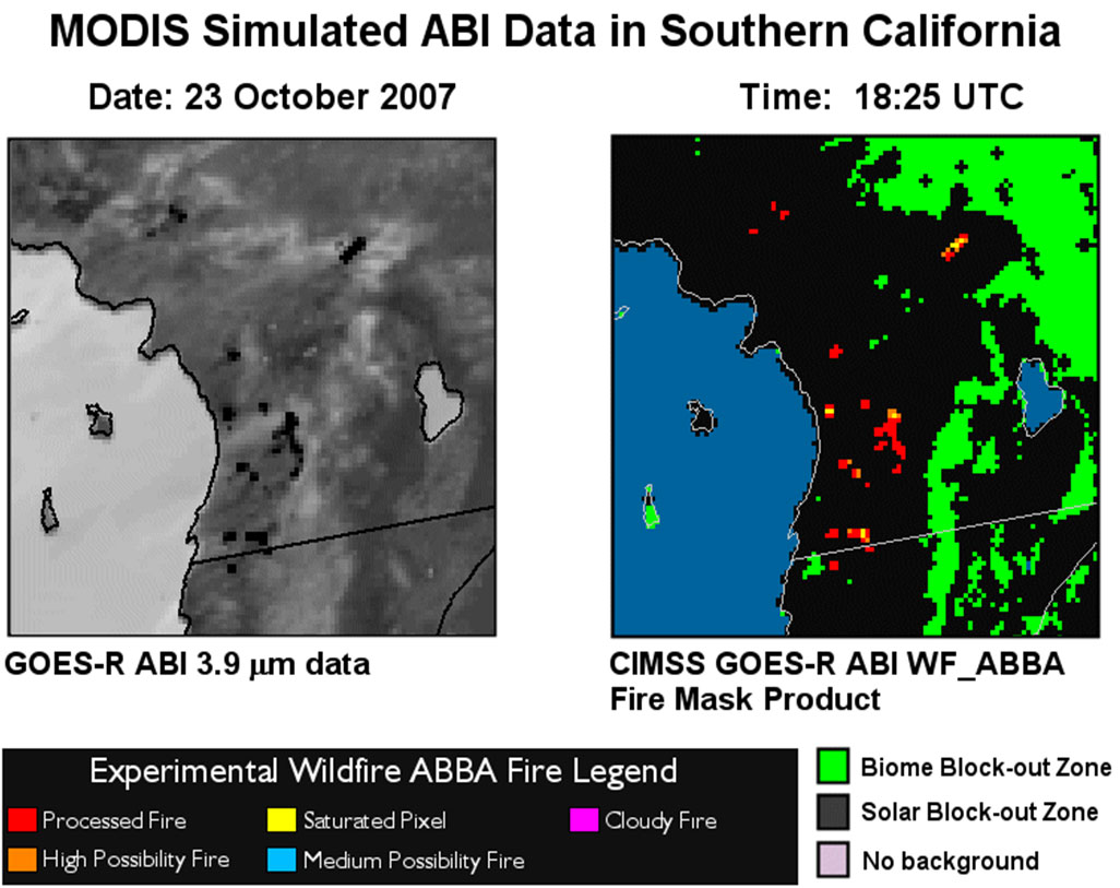
fileDescription: Example of the Fire/Hot Spot Characterization product as derived by the GOES-R Fire/Hot Spot Characterization algorithm using simulated GOES-R ABI 3.9 µm data over Southern California at 1825 UTC on 23 October 2007.
fileType: JPEG
descriptiveKeywords: (MD_Keywords)
keyword: Earth Science > Human Dimensions > Natural Hazards > Wildfires
keyword: Earth Science > Biosphere > Ecological Dynamics > Fire Ecology > Fire Occurance
keyword: Earth Science > Biosphere > Ecological Dynamics > Fire Ecology > Fire Dynamics
type: (MD_KeywordTypeCode) theme
thesaurusName: (CI_Citation)
title: Global Change Master Directory (GCMD) Science Keywords
date: (CI_Date)
date: 2018
dateType: (CI_DateTypeCode) revision
edition: Version 8.6
citedResponsibleParty: (CI_ResponsibleParty)
organisationName: Global Change Data Center, Science and Exploration Directorate, Goddard Space Flight Center (GSFC) National Aeronautics and Space Administration (NASA)
contactInfo: (CI_Contact)
onlineResource: (CI_OnlineResource)
linkage: https://earthdata.nasa.gov/about/gcmd/global-change-master-directory-gcmd-keywords
protocol: HTTPS
applicationProfile: Web Browser
name: Global Change Master Directory (GCMD) Keywords
description: The information provided on this page seeks to define how the GCMD Keywords are structured, used and accessed. It also provides information on how users can participate in the further development of the keywords.
function: (CI_OnLineFunctionCode) information
role: (CI_RoleCode) publisher
descriptiveKeywords: (MD_Keywords)
keyword: Terrestrial - Fire Disturbance
type: (MD_KeywordTypeCode) theme
thesaurusName: (CI_Citation)
title: Global Climate Observing System (GCOS) Essential Climate Variables (ECVs)
date: (CI_Date)
date: 2017
dateType: (CI_DateTypeCode) publication
edition: Release 2017
citedResponsibleParty: (CI_ResponsibleParty)
organisationName: World Meteorological Organization, United Nations
contactInfo: (CI_Contact)
onlineResource: (CI_OnlineResource)
linkage: https://public.wmo.int/en/programmes/global-climate-observing-system/essential-climate-variables
protocol: HTTP
applicationProfile: Information
name: GCOS Essential Climate Variables
description: Overview of the GCOS Essential Climate Variables.
function: (CI_OnLineFunctionCode) information
role: (CI_RoleCode) custodian
descriptiveKeywords: (MD_Keywords)
keyword: Geographic Region > Equatorial
keyword: Geographic Region > Mid-Latitude
keyword: Geographic Region > Northern Hemisphere
keyword: Geographic Region > Southern Hemisphere
keyword: Geographic Region > Western Hemisphere
keyword: Geographic Region > Tropics
keyword: Continent > North America > United States Of America
keyword: Continent > North America > Central America
keyword: Continent > South America
keyword: Ocean > Atlantic Ocean
keyword: Ocean > Pacific Ocean
type: (MD_KeywordTypeCode) place
thesaurusName: (CI_Citation)
title: Global Change Master Directory (GCMD) Location Keywords
date: (CI_Date)
date: 2018
dateType: (CI_DateTypeCode) revision
edition: Version 8.6
citedResponsibleParty: (CI_ResponsibleParty)
organisationName: Global Change Data Center, Science and Exploration Directorate, Goddard Space Flight Center (GSFC) National Aeronautics and Space Administration (NASA)
contactInfo: (CI_Contact)
onlineResource: (CI_OnlineResource)
linkage: https://earthdata.nasa.gov/about/gcmd/global-change-master-directory-gcmd-keywords
protocol: HTTPS
applicationProfile: Web Browser
name: Global Change Master Directory (GCMD) Keywords
description: The information provided on this page seeks to define how the GCMD Keywords are structured, used and accessed. It also provides information on how users can participate in the further development of the keywords.
function: (CI_OnLineFunctionCode) information
role: (CI_RoleCode) publisher
descriptiveKeywords: (MD_Keywords)
keyword: Vertical Location > Land Surface
type: (MD_KeywordTypeCode) stratum
thesaurusName: (CI_Citation)
title: Global Change Master Directory (GCMD) Location Keywords
date: (CI_Date)
date: 2018
dateType: (CI_DateTypeCode) revision
edition: Version 8.6
citedResponsibleParty: (CI_ResponsibleParty)
organisationName: Global Change Data Center, Science and Exploration Directorate, Goddard Space Flight Center (GSFC) National Aeronautics and Space Administration (NASA)
contactInfo: (CI_Contact)
onlineResource: (CI_OnlineResource)
linkage: https://earthdata.nasa.gov/about/gcmd/global-change-master-directory-gcmd-keywords
protocol: HTTPS
applicationProfile: Web Browser
name: Global Change Master Directory (GCMD) Keywords
description: The information provided on this page seeks to define how the GCMD Keywords are structured, used and accessed. It also provides information on how users can participate in the further development of the keywords.
function: (CI_OnLineFunctionCode) information
role: (CI_RoleCode) publisher
descriptiveKeywords: (MD_Keywords)
keyword: GOES > Geostationary Operational Environmental Satellites
keyword: ABI-L2-FDC
keyword: gov.noaa.class:GRABIPRD
keyword: GRABIPRD
type: (MD_KeywordTypeCode) project
thesaurusName: (CI_Citation)
title: Global Change Master Directory (GCMD) Project Keywords
date: (CI_Date)
date: 2018
dateType: (CI_DateTypeCode) revision
edition: Version 8.6
citedResponsibleParty: (CI_ResponsibleParty)
organisationName: Global Change Data Center, Science and Exploration Directorate, Goddard Space Flight Center (GSFC) National Aeronautics and Space Administration (NASA)
contactInfo: (CI_Contact)
onlineResource: (CI_OnlineResource)
linkage: https://earthdata.nasa.gov/about/gcmd/global-change-master-directory-gcmd-keywords
protocol: HTTPS
applicationProfile: Web Browser
name: Global Change Master Directory (GCMD) Keywords
description: The information provided on this page seeks to define how the GCMD Keywords are structured, used and accessed. It also provides information on how users can participate in the further development of the keywords.
function: (CI_OnLineFunctionCode) information
role: (CI_RoleCode) publisher
descriptiveKeywords: (MD_Keywords)
keyword: ABI > Advanced Baseline Imager
type: (MD_KeywordTypeCode) instrument
thesaurusName: (CI_Citation)
title: Global Change Master Directory (GCMD) Instrument Keywords
date: (CI_Date)
date: 2018
dateType: (CI_DateTypeCode) revision
edition: Version 8.6
citedResponsibleParty: (CI_ResponsibleParty)
organisationName: Global Change Data Center, Science and Exploration Directorate, Goddard Space Flight Center (GSFC) National Aeronautics and Space Administration (NASA)
contactInfo: (CI_Contact)
onlineResource: (CI_OnlineResource)
linkage: https://earthdata.nasa.gov/about/gcmd/global-change-master-directory-gcmd-keywords
protocol: HTTPS
applicationProfile: Web Browser
name: Global Change Master Directory (GCMD) Keywords
description: The information provided on this page seeks to define how the GCMD Keywords are structured, used and accessed. It also provides information on how users can participate in the further development of the keywords.
function: (CI_OnLineFunctionCode) information
role: (CI_RoleCode) publisher
descriptiveKeywords: (MD_Keywords)
keyword: GOES-16 > Geostationary Operational Environmental Satellite 16
keyword: GOES-17 > Geostationary Operational Environmental Satellite 17
keyword: GOES-18 > Geostationary Operational Environmental Satellite 18
type: (MD_KeywordTypeCode) platform
thesaurusName: (CI_Citation)
title: Global Change Master Directory (GCMD) Platform Keywords
date: (CI_Date)
date: 2018
dateType: (CI_DateTypeCode) revision
edition: Version 8.6
citedResponsibleParty: (CI_ResponsibleParty)
organisationName: Global Change Data Center, Science and Exploration Directorate, Goddard Space Flight Center (GSFC) National Aeronautics and Space Administration (NASA)
contactInfo: (CI_Contact)
onlineResource: (CI_OnlineResource)
linkage: https://earthdata.nasa.gov/about/gcmd/global-change-master-directory-gcmd-keywords
protocol: HTTPS
applicationProfile: Web Browser
name: Global Change Master Directory (GCMD) Keywords
description: The information provided on this page seeks to define how the GCMD Keywords are structured, used and accessed. It also provides information on how users can participate in the further development of the keywords.
function: (CI_OnLineFunctionCode) information
role: (CI_RoleCode) publisher
descriptiveKeywords: (MD_Keywords)
keyword: 1 km - < 10 km or approximately .01 degree - < .09 degree
type: (MD_KeywordTypeCode) dataResolution
thesaurusName: (CI_Citation)
title: Global Change Master Directory (GCMD) Horizontal Data Resolution Keywords
date: (CI_Date)
date: 2018
dateType: (CI_DateTypeCode) revision
edition: Version 8.6
citedResponsibleParty: (CI_ResponsibleParty)
organisationName: Global Change Data Center, Science and Exploration Directorate, Goddard Space Flight Center (GSFC) National Aeronautics and Space Administration (NASA)
contactInfo: (CI_Contact)
onlineResource: (CI_OnlineResource)
linkage: https://earthdata.nasa.gov/about/gcmd/global-change-master-directory-gcmd-keywords
protocol: HTTPS
applicationProfile: Web Browser
name: Global Change Master Directory (GCMD) Keywords
description: The information provided on this page seeks to define how the GCMD Keywords are structured, used and accessed. It also provides information on how users can participate in the further development of the keywords.
function: (CI_OnLineFunctionCode) information
role: (CI_RoleCode) publisher
descriptiveKeywords: (MD_Keywords)
keyword: 1 minute - < 1 hour
type: (MD_KeywordTypeCode) dataResolution
thesaurusName: (CI_Citation)
title: Global Change Master Directory (GCMD) Temporal Data Resolution Keywords
date: (CI_Date)
date: 2018
dateType: (CI_DateTypeCode) revision
edition: Version 8.6
citedResponsibleParty: (CI_ResponsibleParty)
organisationName: Global Change Data Center, Science and Exploration Directorate, Goddard Space Flight Center (GSFC) National Aeronautics and Space Administration (NASA)
contactInfo: (CI_Contact)
onlineResource: (CI_OnlineResource)
linkage: https://earthdata.nasa.gov/about/gcmd/global-change-master-directory-gcmd-keywords
protocol: HTTPS
applicationProfile: Web Browser
name: Global Change Master Directory (GCMD) Keywords
description: The information provided on this page seeks to define how the GCMD Keywords are structured, used and accessed. It also provides information on how users can participate in the further development of the keywords.
function: (CI_OnLineFunctionCode) information
role: (CI_RoleCode) publisher
descriptiveKeywords: (MD_Keywords)
keyword: DOC/NOAA/NESDIS/NCDC > National Climatic Data Center, NESDIS, NOAA, U.S. Department of Commerce
keyword: DOC/NOAA/NESDIS/NCEI > National Centers for Environmental Information, NESDIS, NOAA, U.S. Department of Commerce
keyword: DOC/NOAA/NESDIS/STAR > Center for Satellite Applications and Research, NESDIS, NOAA, U.S. Department of Commerce
keyword: DOC/NOAA/NESDIS/OSPO > Office of Satellite and Product Operations, NESDIS, NOAA, U.S. Department of Commerce
type: (MD_KeywordTypeCode) dataCentre
thesaurusName: (CI_Citation)
title: Global Change Master Directory (GCMD) Data Center Keywords
date: (CI_Date)
date: 2018
dateType: (CI_DateTypeCode) revision
edition: Version 8.6
citedResponsibleParty: (CI_ResponsibleParty)
organisationName: Global Change Data Center, Science and Exploration Directorate, Goddard Space Flight Center (GSFC) National Aeronautics and Space Administration (NASA)
contactInfo: (CI_Contact)
onlineResource: (CI_OnlineResource)
linkage: https://earthdata.nasa.gov/about/gcmd/global-change-master-directory-gcmd-keywords
protocol: HTTPS
applicationProfile: Web Browser
name: Global Change Master Directory (GCMD) Keywords
description: The information provided on this page seeks to define how the GCMD Keywords are structured, used and accessed. It also provides information on how users can participate in the further development of the keywords.
function: (CI_OnLineFunctionCode) information
role: (CI_RoleCode) publisher
descriptiveKeywords: (MD_Keywords)
keyword: gov.noaa.class:GRABIPRD
type: (MD_KeywordTypeCode) project
resourceConstraints: (MD_Constraints)
useLimitation: For a complete description of use limitations for this dataset, refer to the Algorithm Theoretical Basis Document (ATBD).
resourceConstraints: (MD_LegalConstraints)
useConstraints: (MD_RestrictionCode) otherRestrictions
otherConstraints: Cite as: GOES-R Algorithm Working Group and GOES-R Program Office, (2018): NOAA GOES-R Series Advanced Baseline Imager (ABI) Level 2 Fire/Hot Spot Characterization (FDC). [indicate subset used]. NOAA National Centers for Environmental Information. doi:10.7289/V5X065CR [access date].
resourceConstraints: (MD_LegalConstraints)
accessConstraints: (MD_RestrictionCode) otherRestrictions
otherConstraints: Distribution liability: NOAA and NCEI make no warranty, expressed or implied, regarding these data, nor does the fact of distribution constitute such a warranty. NOAA and NCEI cannot assume liability for any damages caused by any errors or omissions in these data. If appropriate, NCEI can only certify that the data it distributes are an authentic copy of the records that were accepted for inclusion in the NCEI archives.
resourceConstraints: (MD_LegalConstraints)
useConstraints: (MD_RestrictionCode) otherRestrictions
otherConstraints: Use liability: NOAA and NCEI cannot provide any warranty as to the accuracy, reliability, or completeness of furnished data. Users assume responsibility to determine the usability of these data. The user is responsible for the results of any application of this data for other than its intended purpose.
aggregationInfo: (MD_AggregateInformation)
aggregateDataSetName: (CI_Citation)
title: GOES-R Program Document Library
date: (missing)
citedResponsibleParty: (CI_ResponsibleParty)
organisationName: (missing)
contactInfo: (CI_Contact)
onlineResource: (CI_OnlineResource)
linkage: https://www.goes-r.gov/resources/docs.html
applicationProfile: Web Browser
name: GOES-R Program Document Library
description: Webpage with product algorithm, users guides, and education and outreach materials.
function: (CI_OnLineFunctionCode) information
role: (missing)
associationType: (DS_AssociationTypeCode) crossReference
initiativeType: (DS_InitiativeTypeCode) userGuide
aggregationInfo: (MD_AggregateInformation)
aggregateDataSetName: (CI_Citation)
title: GOES Operational Status - NOAA Office of Satellite and Product Operations
date: (missing)
citedResponsibleParty: (CI_ResponsibleParty)
organisationName: (missing)
contactInfo: (CI_Contact)
onlineResource: (CI_OnlineResource)
linkage: https://www.ospo.noaa.gov/Operations/GOES/status.html
applicationProfile: Web Browser
name: GOES Operational Status - NOAA Office of Satellite and Product Operations
description: GOES spacecraft status page.
function: (CI_OnLineFunctionCode) information
role: (missing)
associationType: (DS_AssociationTypeCode) crossReference
initiativeType: (DS_InitiativeTypeCode) userGuide
spatialRepresentationType: (MD_SpatialRepresentationTypeCode) grid
spatialResolution: (MD_Resolution)
distance:
Distance: 2000
language: eng; USA
topicCategory: (MD_TopicCategoryCode) climatologyMeteorologyAtmosphere
extent: (EX_Extent)
geographicElement: (EX_GeographicBoundingBox)
extentTypeCode: 1
westBoundLongitude: -156.2995
eastBoundLongitude: 6.2995
southBoundLatitude: -81.3282
northBoundLatitude: 81.3282
temporalElement: (EX_TemporalExtent)
extent:
TimePeriod:
description: ground condition
beginPosition: 2017-05-24
endPosition:
timeInterval: 10
return to top
contentInfo: (MI_CoverageDescription)
attributeDescription:
RecordType: OR_ABI-L2-FDCF-M3_G16_sYYYYDDDHHMMSS_eYYYYDDDHHMMSS_cYYYYDDDHHMMSS.nc
contentType: (MD_CoverageContentTypeCode) physicalMeasurement
dimension: (MD_Band)
sequenceIdentifier:
MemberName:
aName: Area
attributeType:
TypeName:
aName: short
descriptor: ABI L2+ Fire-Hot Spot Characterization: Fire Area (fire_area)
units: http://example.org/someUnitsDictionary.xml#km2
dimension: (MD_Band)
sequenceIdentifier:
MemberName:
aName: Temp
attributeType:
TypeName:
aName: short
descriptor: ABI L2+ Fire-Hot Spot Characterization: Fire Temperature (fire_temperature)
units: http://example.org/someUnitsDictionary.xml#K
dimension: (MD_Band)
sequenceIdentifier:
MemberName:
aName: Mask
attributeType:
TypeName:
aName: short
descriptor: ABI L2+ Fire - Hot Spot Characterization: Fire Mask
units: http://example.org/someUnitsDictionary.xml#1
dimension: (MD_Band)
sequenceIdentifier:
MemberName:
aName: Power
attributeType:
TypeName:
aName: float
descriptor: ABI L2+ Fire-Hot Spot Characterization: Fire Radiative Power (fire_radiative_power)
units: http://example.org/someUnitsDictionary.xml#MW
dimension: (MD_Band)
sequenceIdentifier:
MemberName:
aName: DQF
attributeType:
TypeName:
aName: byte
descriptor: ABI L2+ Fire - Hot Spot Characterization data quality flags (status_flag)
units: http://example.org/someUnitsDictionary.xml#1
dimension: (MD_Band)
sequenceIdentifier:
MemberName:
aName: t
attributeType:
TypeName:
aName: double
descriptor: J2000 epoch mid-point between the start and end image scan in seconds (time)
units: http://example.org/someUnitsDictionary.xml#seconds%20since%202000-01-01%2012%3A00%3A00
dimension: (MD_Band)
sequenceIdentifier:
MemberName:
aName: y
attributeType:
TypeName:
aName: short
descriptor: GOES fixed grid projection y-coordinate (projection_y_coordinate)
units: http://example.org/someUnitsDictionary.xml#rad
dimension: (MD_Band)
sequenceIdentifier:
MemberName:
aName: x
attributeType:
TypeName:
aName: short
descriptor: GOES fixed grid projection x-coordinate (projection_x_coordinate)
units: http://example.org/someUnitsDictionary.xml#rad
dimension: (MD_Band)
sequenceIdentifier:
MemberName:
aName: time_bounds
attributeType:
TypeName:
aName: double
descriptor: Scan start and end times in seconds since epoch (2000-01-01 12:00:00)
dimension: (MD_Band)
sequenceIdentifier:
MemberName:
aName: goes_imager_projection
attributeType:
TypeName:
aName: int
descriptor: GOES-R ABI fixed grid projection
dimension: (MD_Band)
sequenceIdentifier:
MemberName:
aName: y_image
attributeType:
TypeName:
aName: float
descriptor: GOES-R fixed grid projection y-coordinate center of image (projection_y_coordinate)
units: http://example.org/someUnitsDictionary.xml#rad
dimension: (MD_Band)
sequenceIdentifier:
MemberName:
aName: y_image_bounds
attributeType:
TypeName:
aName: float
descriptor: GOES-R fixed grid projection y-coordinate north/south extent of image
dimension: (MD_Band)
sequenceIdentifier:
MemberName:
aName: x_image
attributeType:
TypeName:
aName: float
descriptor: GOES-R fixed grid projection x-coordinate center of image (projection_x_coordinate)
units: http://example.org/someUnitsDictionary.xml#rad
dimension: (MD_Band)
sequenceIdentifier:
MemberName:
aName: x_image_bounds
attributeType:
TypeName:
aName: float
descriptor: GOES-R fixed grid projection x-coordinate west/east extent of image
dimension: (MD_Band)
sequenceIdentifier:
MemberName:
aName: nominal_satellite_subpoint_lat
attributeType:
TypeName:
aName: float
descriptor: nominal satellite subpoint latitude (platform latitude) (latitude)
units: http://example.org/someUnitsDictionary.xml#degrees_north
dimension: (MD_Band)
sequenceIdentifier:
MemberName:
aName: nominal_satellite_subpoint_lon
attributeType:
TypeName:
aName: float
descriptor: nominal satellite subpoint longitude (platform longitude) (longitude)
units: http://example.org/someUnitsDictionary.xml#degrees_east
dimension: (MD_Band)
sequenceIdentifier:
MemberName:
aName: nominal_satellite_height
attributeType:
TypeName:
aName: float
descriptor: nominal satellite height above GRS 80 ellipsoid (platform altitude) (height_above_reference_ellipsoid)
units: http://example.org/someUnitsDictionary.xml#km
dimension: (MD_Band)
sequenceIdentifier:
MemberName:
aName: geospatial_lat_lon_extent
attributeType:
TypeName:
aName: float
descriptor: geospatial latitude and longitude references
dimension: (MD_Band)
sequenceIdentifier:
MemberName:
aName: sunglint_angle
attributeType:
TypeName:
aName: float
descriptor: threshold angle between the line of sight to the satellite and the direction of the beam of incident solar radiation for good quality fire-hot spot characterization data production (sunglint_angle)
units: http://example.org/someUnitsDictionary.xml#degree
dimension: (MD_Band)
sequenceIdentifier:
MemberName:
aName: sunglint_angle_bounds
attributeType:
TypeName:
aName: float
descriptor: sunglint angle degree range where fire-hot spot characterization data is not produced
dimension: (MD_Band)
sequenceIdentifier:
MemberName:
aName: local_zenith_angle
attributeType:
TypeName:
aName: float
descriptor: threshold angle between the line of sight to the satellite and the local zenith at the observation target for good quality fire-hot spot characterization data production (platform_zenith_angle)
units: http://example.org/someUnitsDictionary.xml#degree
dimension: (MD_Band)
sequenceIdentifier:
MemberName:
aName: local_zenith_angle_bounds
attributeType:
TypeName:
aName: float
descriptor: local zenith angle degree range where good quality fire-hot spot characterization data is produced
dimension: (MD_Band)
sequenceIdentifier:
MemberName:
aName: solar_zenith_angle
attributeType:
TypeName:
aName: float
descriptor: threshold angle between the line of sight to the sun and the local zenith at the observation target for good quality fire-hot spot characterization data production (solar_zenith_angle)
units: http://example.org/someUnitsDictionary.xml#degree
dimension: (MD_Band)
sequenceIdentifier:
MemberName:
aName: solar_zenith_angle_bounds
attributeType:
TypeName:
aName: float
descriptor: solar zenith angle degree range where good quality fire-hot spot characterization data is produced
dimension: (MD_Band)
sequenceIdentifier:
MemberName:
aName: total_number_of_pixels_with_fires_detected
attributeType:
TypeName:
aName: int
descriptor: total number of pixels with fires detected
units: http://example.org/someUnitsDictionary.xml#count
dimension: (MD_Band)
sequenceIdentifier:
MemberName:
aName: total_number_of_pixels_with_fire_temperature
attributeType:
TypeName:
aName: int
descriptor: total number of pixels with fire temperature reported
units: http://example.org/someUnitsDictionary.xml#count
dimension: (MD_Band)
sequenceIdentifier:
MemberName:
aName: total_number_of_pixels_with_fire_area
attributeType:
TypeName:
aName: int
descriptor: total number of pixels with fire area reported
units: http://example.org/someUnitsDictionary.xml#count
dimension: (MD_Band)
sequenceIdentifier:
MemberName:
aName: total_number_of_pixels_with_fire_radiative_power
attributeType:
TypeName:
aName: int
descriptor: total number of pixels with fire radiative power reported
units: http://example.org/someUnitsDictionary.xml#count
dimension: (MD_Band)
sequenceIdentifier:
MemberName:
aName: fire_temperature_outlier_pixel_count
attributeType:
TypeName:
aName: int
descriptor: number of pixels with fire temperature reported whose value is outside valid measurement range
units: http://example.org/someUnitsDictionary.xml#count
dimension: (MD_Band)
sequenceIdentifier:
MemberName:
aName: fire_area_outlier_pixel_count
attributeType:
TypeName:
aName: int
descriptor: number of pixels with fire area reported whose value is outside valid measurement range
units: http://example.org/someUnitsDictionary.xml#count
dimension: (MD_Band)
sequenceIdentifier:
MemberName:
aName: fire_radiative_power_outlier_pixel_count
attributeType:
TypeName:
aName: int
descriptor: number of pixels with fire radiative power reported whose value is outside valid measurement range
units: http://example.org/someUnitsDictionary.xml#count
dimension: (MD_Band)
sequenceIdentifier:
MemberName:
aName: minimum_fire_temperature
attributeType:
TypeName:
aName: float
descriptor: minimum fire temperature (fire_temperature)
units: http://example.org/someUnitsDictionary.xml#K
dimension: (MD_Band)
sequenceIdentifier:
MemberName:
aName: maximum_fire_temperature
attributeType:
TypeName:
aName: float
descriptor: maximum fire temperature (fire_temperature)
units: http://example.org/someUnitsDictionary.xml#K
dimension: (MD_Band)
sequenceIdentifier:
MemberName:
aName: mean_fire_temperature
attributeType:
TypeName:
aName: float
descriptor: mean fire temperature (fire_temperature)
units: http://example.org/someUnitsDictionary.xml#K
dimension: (MD_Band)
sequenceIdentifier:
MemberName:
aName: standard_deviation_fire_temperature
attributeType:
TypeName:
aName: float
descriptor: standard deviation of fire temperature values (fire_temperature)
units: http://example.org/someUnitsDictionary.xml#K
dimension: (MD_Band)
sequenceIdentifier:
MemberName:
aName: minimum_fire_area
attributeType:
TypeName:
aName: float
descriptor: minimum fire area (fire_area)
units: http://example.org/someUnitsDictionary.xml#km2
dimension: (MD_Band)
sequenceIdentifier:
MemberName:
aName: maximum_fire_area
attributeType:
TypeName:
aName: float
descriptor: maximum fire area (fire_area)
units: http://example.org/someUnitsDictionary.xml#km2
dimension: (MD_Band)
sequenceIdentifier:
MemberName:
aName: mean_fire_area
attributeType:
TypeName:
aName: float
descriptor: mean fire area (fire_area)
units: http://example.org/someUnitsDictionary.xml#km2
dimension: (MD_Band)
sequenceIdentifier:
MemberName:
aName: standard_deviation_fire_area
attributeType:
TypeName:
aName: float
descriptor: standard deviation of fire area values (fire_area)
units: http://example.org/someUnitsDictionary.xml#km2
dimension: (MD_Band)
sequenceIdentifier:
MemberName:
aName: minimum_fire_radiative_power
attributeType:
TypeName:
aName: float
descriptor: minimum fire radiative power (fire_radiative_power)
units: http://example.org/someUnitsDictionary.xml#MW
dimension: (MD_Band)
sequenceIdentifier:
MemberName:
aName: maximum_fire_radiative_power
attributeType:
TypeName:
aName: float
descriptor: maximum fire radiative power (fire_radiative_power)
units: http://example.org/someUnitsDictionary.xml#MW
dimension: (MD_Band)
sequenceIdentifier:
MemberName:
aName: mean_fire_radiative_power
attributeType:
TypeName:
aName: float
descriptor: mean fire radiative power (fire_radiative_power)
units: http://example.org/someUnitsDictionary.xml#MW
dimension: (MD_Band)
sequenceIdentifier:
MemberName:
aName: standard_deviation_fire_radiative_power
attributeType:
TypeName:
aName: float
descriptor: standard deviation of fire radiative power values (fire_radiative_power)
units: http://example.org/someUnitsDictionary.xml#MW
dimension: (MD_Band)
sequenceIdentifier:
MemberName:
aName: algorithm_dynamic_input_data_container
attributeType:
TypeName:
aName: int
descriptor: container for filenames of dynamic algorithm input data
dimension: (MD_Band)
sequenceIdentifier:
MemberName:
aName: processing_parm_version_container
attributeType:
TypeName:
aName: int
descriptor: container for processing parameter filenames
dimension: (MD_Band)
sequenceIdentifier:
MemberName:
aName: algorithm_product_version_container
attributeType:
TypeName:
aName: int
descriptor: container for algorithm package filename and product version
dimension: (MD_Band)
sequenceIdentifier:
MemberName:
aName: percent_uncorrectable_GRB_errors
attributeType:
TypeName:
aName: float
descriptor: percent data lost due to uncorrectable GRB errors
units: http://example.org/someUnitsDictionary.xml#percent
dimension: (MD_Band)
sequenceIdentifier:
MemberName:
aName: percent_uncorrectable_L0_errors
attributeType:
TypeName:
aName: float
descriptor: percent data lost due to uncorrectable L0 errors
units: http://example.org/someUnitsDictionary.xml#percent
return to top
distributionInfo: (MD_Distribution)
distributor: (MD_Distributor)
distributorContact: (CI_ResponsibleParty)
organisationName: NOAA National Centers for Environmental Information
contactInfo: (CI_Contact)
address: (CI_Address)
electronicMailAddress: ncei.info@noaa.gov
onlineResource: (CI_OnlineResource)
linkage: https://www.ncei.noaa.gov/contact
name: NCEI Contact Information
description: Information for contacts at NCEI.
function: (CI_OnLineFunctionCode) information
role: (CI_RoleCode) distributor
distributionOrderProcess: (MD_StandardOrderProcess)
fees: In most cases, electronic downloads of the data are free. However, fees may apply for custom orders, data certifications, copies of analog materials, and data distribution on physical media.
orderingInstructions: Contact NCEI for other distribution options and instructions.
distributorFormat: (MD_Format)
name: NetCDF
version: 4
distributorTransferOptions: (MD_DigitalTransferOptions)
onLine: (CI_OnlineResource)
linkage: https://doi.org/10.7289/V5X065CR
protocol: HTTPS
applicationProfile: Landing Page
name: NCEI Dataset Landing Page
description: Landing page for the dataset.
function: (CI_OnLineFunctionCode) information
distributorTransferOptions: (MD_DigitalTransferOptions)
onLine: (CI_OnlineResource)
linkage: https://www.ncdc.noaa.gov/airs-web/search
protocol: HTTPS
applicationProfile: Data Search Application
name: NCEI Archive Information Request System
description: Search the data archive and submit an order for the dataset via the interface.
function: (CI_OnLineFunctionCode) order
distributorTransferOptions: (MD_DigitalTransferOptions)
onLine: (CI_OnlineResource)
linkage: http://www.class.noaa.gov/saa/products/search?datatype_family=GRABIPRD
protocol: HTTPS
applicationProfile: Data Search Application
name: NOAA CLASS Data Search and Order
description: Search the data archive and submit an order for the dataset via the interface.
function: (CI_OnLineFunctionCode) order
distributorTransferOptions: (MD_DigitalTransferOptions)
onLine: (CI_OnlineResource)
linkage: https://www.ncei.noaa.gov/products/goes-terrestrial-weather-abi-glm
protocol: HTTPS
applicationProfile: Information
name: NCEI GOES-R Terrestrial Weather (ABI/GLM)
description: Description of the products and related resources.
function: (CI_OnLineFunctionCode) information
distributorTransferOptions: (MD_DigitalTransferOptions)
onLine: (CI_OnlineResource)
linkage: https://www.goes-r.gov/users/docs/PUG-main-vol1.pdf
applicationProfile: Documentation
name: Product Definition and Users' Guide (PUG) Vol.1 Main
description: The Product Definition and User's Guide (PUG) document provides product descriptions and formats for all data and products produced and made available to users by the Geostationary Operational Environmental Satellite R Series (GOES-R) Core Ground Segment (GS).
function: (CI_OnLineFunctionCode) information
distributorTransferOptions: (MD_DigitalTransferOptions)
onLine: (CI_OnlineResource)
linkage: https://www.goes-r.gov/products/docs/PUG-L2+-vol5.pdf
applicationProfile: Documentation
name: Product Definition and Users' Guide (PUG) Vol.5 Level 2+ Products
description: The Product Definition and User's Guide (PUG) document provides product descriptions and formats for all data and products produced and made available to users by the Geostationary Operational Environmental Satellite R Series (GOES-R) Core Ground Segment (GS).
function: (CI_OnLineFunctionCode) information
distributorTransferOptions: (MD_DigitalTransferOptions)
onLine: (CI_OnlineResource)
linkage: https://registry.opendata.aws/noaa-goes/
protocol: HTTPS
applicationProfile: Information
name: Registry of Open Data on AWS
description: Information on AWS data access.
function: (CI_OnLineFunctionCode) information
distributorTransferOptions: (MD_DigitalTransferOptions)
unitsOfDistribution: Region: us-east-1
onLine: (CI_OnlineResource)
linkage: https://noaa-goes16.s3.amazonaws.com/index.html
protocol: HTTPS
applicationProfile: Download
name: GOES-16 AWS S3 Explorer (Region: us-east-1)
description: Browse view to explore the S3 bucket for GOES-16 datasets. Data relevant to this can be found in folders with the prefix ABI-L2-FDC.
function: (CI_OnLineFunctionCode) download
distributorTransferOptions: (MD_DigitalTransferOptions)
unitsOfDistribution: Region: us-east-1
onLine: (CI_OnlineResource)
linkage: https://noaa-goes17.s3.amazonaws.com/index.html
protocol: HTTPS
applicationProfile: Download
name: GOES-17 AWS S3 Explorer (Region: us-east-1)
description: Browse view to explore the S3 bucket for GOES-17 datasets. Data relevant to this can be found in folders with the prefix ABI-L2-FDC.
function: (CI_OnLineFunctionCode) download
distributorTransferOptions: (MD_DigitalTransferOptions)
unitsOfDistribution: Region: us-east-1
onLine: (CI_OnlineResource)
linkage: https://noaa-goes18.s3.amazonaws.com/index.html
protocol: HTTPS
applicationProfile: Download
name: GOES-18 AWS S3 Explorer (Region: us-east-1)
description: Browse view to explore the S3 bucket for GOES-18 datasets. Data relevant to this can be found in folders with the prefix ABI-L2-FDC.
function: (CI_OnLineFunctionCode) download
distributorTransferOptions: (MD_DigitalTransferOptions)
unitsOfDistribution: Region: europe-west
onLine: (CI_OnlineResource)
linkage: https://microsoft.github.io/AIforEarthDataSets/data/goes-r.html
protocol: HTTPS
applicationProfile: Information
name: Azure Landing Page (Region: europe-west)
description: Information on Microsoft Azure data access.
function: (CI_OnLineFunctionCode) information
distributorTransferOptions: (MD_DigitalTransferOptions)
unitsOfDistribution: Region: US-multiple
onLine: (CI_OnlineResource)
linkage: https://console.cloud.google.com/storage/browser/gcp-public-data-goes-16
protocol: HTTPS
applicationProfile: Download
name: GOES-16 Google Cloud Bucket Explorer (Region: US-multiple)
description: Browse view to explore the Google Cloud bucket for GOES-16. Data relevant to this can be found in folders with the prefix ABI-L2-FDC.
function: (CI_OnLineFunctionCode) download
distributorTransferOptions: (MD_DigitalTransferOptions)
unitsOfDistribution: Region: US-multiple
onLine: (CI_OnlineResource)
linkage: https://console.cloud.google.com/storage/browser/gcp-public-data-goes-17
protocol: HTTPS
applicationProfile: Download
name: GOES-17 Google Cloud Bucket Explorer (Region: US-multiple)
description: Browse view to explore the Google Cloud bucket for GOES-17. Data relevant to this can be found in folders with the prefix ABI-L2-FDC.
function: (CI_OnLineFunctionCode) download
distributorTransferOptions: (MD_DigitalTransferOptions)
unitsOfDistribution: Region: US-multiple
onLine: (CI_OnlineResource)
linkage: https://console.cloud.google.com/storage/browser/gcp-public-data-goes-18
protocol: HTTPS
applicationProfile: Download
name: GOES-18 Google Cloud Bucket Explorer (Region: US-multiple)
description: Browse view to explore the Google Cloud bucket for GOES-18. Data relevant to this can be found in folders with the prefix ABI-L2-FDC.
function: (CI_OnLineFunctionCode) download
distributorTransferOptions: (MD_DigitalTransferOptions)
unitsOfDistribution: Region: US-multiple
onLine: (CI_OnlineResource)
linkage: https://console.cloud.google.com/marketplace/product/noaa-public/goes/
protocol: HTTPS
applicationProfile: Information
name: Google Cloud Landing Page (Region: US-multiple)
description: Information on Google Cloud data access for GOES datasets.
function: (CI_OnLineFunctionCode) information
return to top
dataQualityInfo: (DQ_DataQuality)
scope: (DQ_Scope)
level: (MD_ScopeCode) dataset
extent: #boundingExtent
lineage: (LI_Lineage)
statement: These data were produced by the NOAA Office of Satellite and Product Operations (OSPO) and are archived at the NOAA National Centers for Environmental Information (NCEI).
processStep: (LE_ProcessStep)
description: The Fire product is generated by the GOES-R ABI Land Fire ground processing algorithm. The Fire algorithm is a dynamic multispectral thresholding algorithm that uses the differences in sensitivity to high temperature subpixel anomalies of ABI bands 7 and 14, with central wavelengths of 3.9 and 11.2 um, respectively. The algorithm consists of a series of screening tests, threshold tests, and calculations that are applied to each pixel. Estimates of subpixel fire area, temperature, and power are computed based on a screening. Additionally, subsequent analysis can introduce additional fire pixels in the fire mask for which fire properties are not derived from the source ABI data. Pixels in the product images with out of range values are assigned the minimum or maximum value in the valid range. Reflectance for band 2 and brightness temperature for band 15 are used in cloud tests but are not required to detect fires. The algorithm maintains "time of last fire" intermediate data for each pixel that is used and updated for each execution of the algorithm.
dateTime: (missing)
processor: (CI_ResponsibleParty)
organisationName: DOC/NOAA/NESDIS/OSPO > Office of Satellite and Product Operations, NESDIS, NOAA, U.S. Department of Commerce
role: (CI_RoleCode) processor
source: sd001
processingInformation: (LE_Processing)
identifier: (missing)
documentation: (CI_Citation)
title: GOES-R Algorithm Working Group
date: (missing)
citedResponsibleParty: (CI_ResponsibleParty)
organisationName: DOC/NOAA/NESDIS/STAR > Center for Satellite Applications and Research, NESDIS, NOAA, U.S. Department of Commerce
role: (CI_RoleCode) publisher
citedResponsibleParty: (CI_ResponsibleParty)
organisationName: (missing)
contactInfo: (CI_Contact)
onlineResource: (CI_OnlineResource)
linkage: https://www.star.nesdis.noaa.gov/goesr/
protocol: HTTPS
applicationProfile: Web Browser
name: GOES-R Algorithm Working Group
description: The GOES-R Algorithm Working Group creates the algorithms that process the quality controlled satellite instrument data and produces resulting data products.
function: (CI_OnLineFunctionCode) information
role: (missing)
documentation: (CI_Citation)
title: NOAA Satellite Information System Product Quality
date: (missing)
citedResponsibleParty: (CI_ResponsibleParty)
organisationName: (missing)
contactInfo: (CI_Contact)
onlineResource: (CI_OnlineResource)
linkage: https://www.noaasis.noaa.gov/GOES/PS_PVR2.html
protocol: HTTPS
applicationProfile: Web Browser
name: NOAA Satellite Information System Product Quality
description: Peer/Stakeholder Product Validation Reviews by satellite and product.
function: (CI_OnLineFunctionCode) information
role: (missing)
algorithm: (LE_Algorithm)
citation: (CI_Citation)
title: GOES-R Algorithm Theoretical Basis Documents
date: (missing)
citedResponsibleParty: (CI_ResponsibleParty)
organisationName: DOC/NOAA/NESDIS/STAR > Center for Satellite Applications and Research, NESDIS, NOAA, U.S. Department of Commerce
role: (CI_RoleCode) publisher
citedResponsibleParty: (CI_ResponsibleParty)
organisationName: (missing)
contactInfo: (CI_Contact)
onlineResource: (CI_OnlineResource)
linkage: https://www.star.nesdis.noaa.gov/goesr/documentation_ATBDs.php
applicationProfile: Web Browser
name: GOES-R Algorithm Theoretical Basis Documents
description: Descriptions of how the algorithms work, their underlying designs, and initial comparison with prior algorithms and results.
function: (CI_OnLineFunctionCode) information
role: (missing)
description: See Algorithm Citation
processStep: (LE_ProcessStep)
description: The GOES-16 ABI Fire/Hot Spot Characterization algorithm reached beta maturity.
dateTime:
DateTime: 2017-05-24T00:00:00
processor: (CI_ResponsibleParty)
organisationName: (missing)
role: (CI_RoleCode) processor
processStep: (LE_ProcessStep)
description: The GOES-16 ABI Fire/Hot Spot Characterization algorithm reached provisional maturity.
dateTime:
DateTime: 2018-03-16T00:00:00
processor: (CI_ResponsibleParty)
organisationName: (missing)
role: (CI_RoleCode) processor
processStep: (LE_ProcessStep)
description: The GOES-16 ABI Fire/Hot Spot Characterization algorithm reached full validation maturity.
dateTime: (missing)
processor: (CI_ResponsibleParty)
organisationName: (missing)
role: (CI_RoleCode) processor
processStep: (LE_ProcessStep)
description: The GOES-17 ABI Fire/Hot Spot Characterization algorithm reached beta maturity.
dateTime:
DateTime: 2018-08-27T00:00:00
processor: (CI_ResponsibleParty)
organisationName: (missing)
role: (CI_RoleCode) processor
processStep: (LE_ProcessStep)
description: The GOES-17 ABI Fire/Hot Spot Characterization algorithm reached provisional maturity.
dateTime:
DateTime: 2019-07-25T00:00:00
processor: (CI_ResponsibleParty)
organisationName: (missing)
role: (CI_RoleCode) processor
processStep: (LE_ProcessStep)
description: The GOES-17 ABI Fire/Hot Spot Characterization algorithm reached full validation maturity.
dateTime: (missing)
processor: (CI_ResponsibleParty)
organisationName: (missing)
role: (CI_RoleCode) processor
source: (LE_Source)
description: Level 1b radiances
sourceCitation: (CI_Citation)
title: NOAA GOES-R Series Advanced Baseline Imager (ABI) Level 1b Radiances
date: (CI_Date)
date: 2017-06-01
dateType: (CI_DateTypeCode) publication
edition: Provisional
identifier: (MD_Identifier)
code: doi:10.7289/V5BV7DSR
citedResponsibleParty: (CI_ResponsibleParty)
organisationName: DOC/NOAA/NESDIS/NCEI > National Centers for Environmental Information, NESDIS, NOAA, U.S. Department of Commerce
role: (CI_RoleCode) distributor
citedResponsibleParty: (CI_ResponsibleParty)
organisationName: (missing)
contactInfo: (CI_Contact)
onlineResource: (CI_OnlineResource)
linkage: https://doi.org/10.7289/V5BV7DSR
protocol: HTTPS
applicationProfile: Web Browser
name: Landing page for ABI-L1-RAD
description: Source dataset landing page with general information and access links for the dataset.
function: (CI_OnLineFunctionCode) information
role: (missing)
sourceExtent: (EX_Extent)
geographicElement: (EX_GeographicBoundingBox)
extentTypeCode: 1
westBoundLongitude: -156.2995
eastBoundLongitude: 6.2995
southBoundLatitude: -81.3282
northBoundLatitude: 81.3282
temporalElement: (EX_TemporalExtent)
extent:
TimePeriod:
beginPosition: 2017-02-28
endPosition:
sourceStep: ps001
return to top
dataQualityInfo: (DQ_DataQuality)
scope: (DQ_Scope)
level: (MD_ScopeCode) repository
levelDescription: (MD_ScopeDescription)
other: NOAA National Centers for Environmental Information
lineage: (LI_Lineage)
processStep: (LE_ProcessStep)
description: NOAA created the National Centers for Environmental Information (NCEI) by merging NOAA's National Climatic Data Center (NCDC), National Geophysical Data Center (NGDC), and National Oceanographic Data Center (NODC), including the National Coastal Data Development Center (NCDDC), per the Consolidated and Further Continuing Appropriations Act, 2015, Public Law 113-235. NCEI launched publicly on April 22, 2015.
dateTime:
DateTime: 2015-04-22T00:00:00
return to top
metadataMaintenance: (MD_MaintenanceInformation)
maintenanceAndUpdateFrequency: (MD_MaintenanceFrequencyCode) asNeeded
maintenanceNote: Bulk metadata change applied on 2023-07-12. See version control repository history for metadata change details.