NOAA GOES-R Series Advanced Baseline Imager (ABI) Level 2 Snow Cover
ABI-L2-FSC
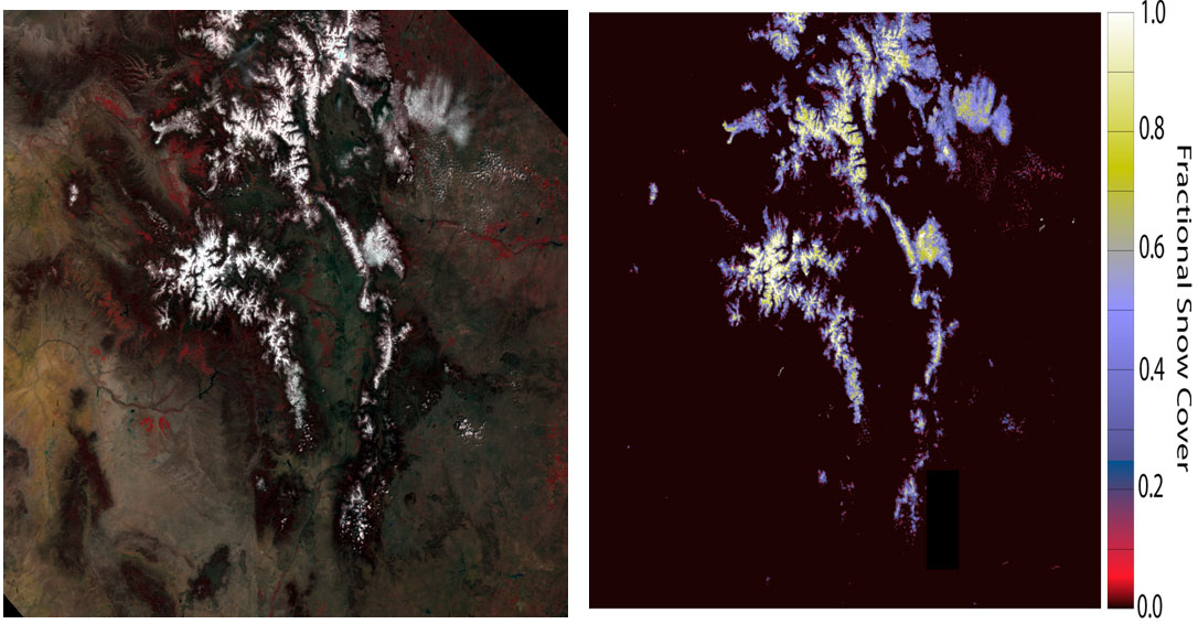 Example of the Snow Cover product (right figure) as generated by the GOES-R Snow Cover algorithm
The GOES-R Advanced Baseline Imager (ABI) Snow Cover product contains an image with pixel values identifying the fraction of their areas covered by snow. The product includes data quality information that provides an assessment of the snow cover data values for on-earth pixels. The units of measure for the snow cover value is percent. The Snow Cover product image is produced on the ABI fixed grid at 2 km resolution for Full Disk, CONUS and Mesoscale coverage regions from GOES East and West. Product data is produced under the following conditions: Existence of land; Clear sky; Geolocated source data to local zenith angles of 90 degrees and solar zenith angles of 90 degrees.
- Cite as: GOES-R Algorithm Working Group and GOES-R Series Program, (2017): NOAA GOES-R Series Advanced Baseline Imager (ABI) Level 2 Snow Cover. [indicate subset used]. NOAA National Centers of Environmental Information. [access date].
- doi:
- ABI-L2-FSC
- gov.noaa.ncdc:C01522
- gov.noaa.class:GRABIPRD
| Download Data |
|
| Order Data |
|
| Distribution Formats |
|
| Ordering Instructions |
Contact NCEI for other distribution options and instructions. |
| Distributor |
NOAA National Centers for Environmental Information
ncei.info@noaa.gov
|
| Dataset Point of Contact |
Customer Engagement Branch
DOC/NOAA/NESDIS/NCEI > National Centers for Environmental Information, NESDIS, NOAA, U.S. Department of Commerce
ncei.sat.info@noaa.gov
|
| Time Period |
2017-12-12 to Present (time interval: 10-minute) |
| Spatial Reference System |
urn:ogc:def:crs:EPSG::4326 |
| Spatial Bounding Box Coordinates |
West: -156.2995
East: 6.2995
South: -81.3282
North: 81.3282
|
| Spatial Coverage Map |
|
| General Documentation |
|
| Processing Documents |
- GOES-R Algorithm Working Group
-
GOES-R Algorithm Working Group
The GOES-R Algorithm Working Group creates the algorithms that process the quality controlled satellite instrument data and produces resulting data products.
- NOAA Satellite Information System Product Quality
- GOES-R Algorithm Theoretical Basis Documents
|
| Associated Resources |
- GOES-R Program Document Library
- GOES Operational Status - NOAA Office of Satellite and Product Operations
|
| Publication Dates |
|
| Edition |
Provisional |
| Data Presentation Form |
Digital image
|
| Dataset Progress Status |
Ongoing - data is continually being updated |
| Data Update Frequency |
Continual |
| Purpose |
The ABI Fractional Snow Cover product will support a number of operational applications that include: assimilation into NOAA's NOHRC snow model, as well as hydrologic forecasts and warnings, including river and flood forecasts, water management, snowpack monitoring and analysis, and climate studies. |
| Use Limitations |
- For a complete description of use limitations for this dataset, refer to the Algorithm Theoretical Basis Document (ATBD).
|
| Dataset Citation |
- Cite as: GOES-R Algorithm Working Group and GOES-R Series Program, (2017): NOAA GOES-R Series Advanced Baseline Imager (ABI) Level 2 Snow Cover. [indicate subset used]. NOAA National Centers of Environmental Information. [access date].
|
| Cited Authors |
- GOES-R Algorithm Working Group
- GOES-R Series Program
|
| Principal Investigators |
- GOES-R Algorithm Working Group
|
| Resource Providers |
|
| Publishers |
- NOAA National Centers for Environmental Information
|
| Theme keywords |
Global Change Master Directory (GCMD) Science Keywords- Earth Science > Climate Indicators > Cryospheric Indicators > Snow Cover
Global Climate Observing System (GCOS) Essential Climate Variables (ECVs)
|
| Data Center keywords |
Global Change Master Directory (GCMD) Data Center Keywords
- DOC/NOAA/NESDIS/NCDC > National Climatic Data Center, NESDIS, NOAA, U.S. Department of Commerce
- DOC/NOAA/NESDIS/NCEI > National Centers for Environmental Information, NESDIS, NOAA, U.S. Department of Commerce
- DOC/NOAA/NESDIS/STAR > Center for Satellite Applications and Research, NESDIS, NOAA, U.S. Department of Commerce
- DOC/NOAA/NESDIS/OSPO > Office of Satellite and Product Operations, NESDIS, NOAA, U.S. Department of Commerce
|
| Platform keywords |
Global Change Master Directory (GCMD) Platform Keywords
- GOES-16 > Geostationary Operational Environmental Satellite 16
- GOES-17 > Geostationary Operational Environmental Satellite 17
- GOES-18 > Geostationary Operational Environmental Satellite 18
|
| Instrument keywords |
Global Change Master Directory (GCMD) Instrument Keywords- ABI > Advanced Baseline Imager
|
| Place keywords |
Global Change Master Directory (GCMD) Location Keywords
- Geographic Region > Equatorial
- Geographic Region > Mid-Latitude
- Geographic Region > Northern Hemisphere
- Geographic Region > Southern Hemisphere
- Geographic Region > Western Hemisphere
- Geographic Region > Tropics
- Continent > North America > United States Of America
- Continent > North America > Central America
- Continent > South America
- Ocean > Atlantic Ocean
- Ocean > Pacific Ocean
|
| Project keywords |
Global Change Master Directory (GCMD) Project Keywords
- GOES > Geostationary Operational Environmental Satellites
- ABI-L2-FSC
- gov.noaa.class:GRABIPRD
- GRABIPRD
|
| Data Resolution keywords |
Global Change Master Directory (GCMD) Horizontal Data Resolution Keywords- 1 km - < 10 km or approximately .01 degree - < .09 degree
|
| Stratum keywords |
Global Change Master Directory (GCMD) Location Keywords- Vertical Location > Land Surface
|
| Use Constraints |
- Cite as: GOES-R Algorithm Working Group and GOES-R Series Program, (2017): NOAA GOES-R Series Advanced Baseline Imager (ABI) Level 2 Snow Cover. [indicate subset used]. NOAA National Centers of Environmental Information. [access date].
- Use liability: NOAA and NCEI cannot provide any warranty as to the accuracy, reliability, or completeness of furnished data. Users assume responsibility to determine the usability of these data. The user is responsible for the results of any application of this data for other than its intended purpose.
|
| Access Constraints |
- Distribution liability: NOAA and NCEI make no warranty, expressed or implied, regarding these data, nor does the fact of distribution constitute such a warranty. NOAA and NCEI cannot assume liability for any damages caused by any errors or omissions in these data. If appropriate, NCEI can only certify that the data it distributes are an authentic copy of the records that were accepted for inclusion in the NCEI archives.
|
| Fees |
- In most cases, electronic downloads of the data are free. However, fees may apply for custom orders, data certifications, copies of analog materials, and data distribution on physical media.
|
| Lineage information for: dataset |
|---|
| Lineage Statement |
The data were produced by the NOAA Office of Satellite and Product Operations (OSPO) and are archived at the NOAA National Centers for Environmental Information (NCEI). |
| Processing Steps |
- The Snow Cover product is generated by the GOES-R ABI Snow Cover ground processing algorithm. The algorithm relies on atmospherically-corrected surface reflectances derived as part of the determination of the surface albedo and does not use ABI Level 1b data inputs directly. The product is generated using spectral mixture analysis with a look-up table containing spectral reflectances of individual surfaces calculated from a radiative transfer model, and also a physical retrieval utilizing a spectral library lookup table to account for the dependency of reflectance on snow grain size, and local and solar zenith angles. The algorithm maintains an endmember memory file that contains two values per pixel indicating the endmember identifiers of the last modeled endmembers. Types of endmembers are land surface materials such as snow, vegetation, and rock, and are characterized using unique reflectance spectra based on modeled and field measurements. The endmemory memory file is re-initialized daily.
- The GOES-16 ABI Snow Cover algorithm reached beta maturity.
- 2020-08-13T00:00:00 - The GOES-16 ABI Snow Cover algorithm reached provisional maturity.
- 2021-01-01T00:00:00 - The GOES-16 ABI Snow Cover algorithm reached full validation maturity.
- The GOES-17 ABI Snow Cover algorithm reached beta maturity.
- 2020-08-13T00:00:00 - The GOES-17 ABI Snow Cover algorithm reached provisional maturity.
- The GOES-17 ABI Snow Cover algorithm reached full validation maturity.
|
| Processing Documents |
- GOES-R Algorithm Working Group
-
GOES-R Algorithm Working Group
The GOES-R Algorithm Working Group creates the algorithms that process the quality controlled satellite instrument data and produces resulting data products.
- NOAA Satellite Information System Product Quality
- GOES-R Algorithm Theoretical Basis Documents
|
| Source Datasets |
- NOAA GOES-R Series Advanced Baseline Imager (ABI) Level 1b Radiances
-
NCEI landing page for ABI-L1B-RAD
Source dataset landing page with general information and access links for the dataset.
- Description of Source: Level 1b radiances
- Temporal extent used: 2017-02-28 to Present
- Spatial extent used: N:81.3282 S:-81.3282 E:6.2995 W:-156.2995
|
| Lineage information for: repository |
|---|
| Processing Steps |
- 2015-04-22T00:00:00 - NOAA created the National Centers for Environmental Information (NCEI) by merging NOAA's National Climatic Data Center (NCDC), National Geophysical Data Center (NGDC), and National Oceanographic Data Center (NODC), including the National Coastal Data Development Center (NCDDC), per the Consolidated and Further Continuing Appropriations Act, 2015, Public Law 113-235. NCEI launched publicly on April 22, 2015.
|
Last Modified: 2023-09-19
For questions about the information on this page, please email:
ncei.info@noaa.gov