NOAA GOES-R Series Advanced Baseline Imager (ABI) Level 2 Reflected Shortwave Radiation Top-of-Atmosphere
ABI-L2-RSR
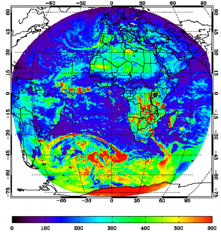 Example of the Reflected Shortwave Radiation (at the top of the atmosphere) product as generated by the GOES-R reflected Shortwave Radiation algorithm.
The GOES-R Advanced Baseline Imager (ABI) Reflected Shortwave Radiation (RSR): TOA product contains an image with pixel values identifying the instantaneous total shortwave irradiance (flux) energing at the Earth's TOA integrated over the 0.2 to 4.0 um wavelength bandpass. It includes contributions from the solar radiation reflected upward by the Earth's surface and that scattered by the atmosphere. The product includes data quality information that provides an assessment of the reflected shortwave radiation: TOA data values for on-earth pixels. The units of measure for the reflected shortwave radiation: TOA value is watts per square meter. The Reflected Shortwave Radiation: TOA product image is produced on a global latitude/longitude grid at 0.25 degree resolution for Full Disk and CONUS coverage regions from GOES East and West. Product data is produced for geolocated source data to local zenith angles of 90 degrees and solar zenith angles to 90 degrees.
- Cite as: GOES-R Algorithm Working Group and GOES-R Program Office, (2017): NOAA GOES-R Series Advanced Baseline Imager (ABI) Level 2 Reflected Shortwave Radiation Top-of-Atmosphere. [indicate subset used]. NOAA National Centers for Environmental Information. [access date].
| Download Data |
|
| Order Data |
|
| Distribution Formats |
|
| Ordering Instructions |
Contact NCEI for other distribution options and instructions. |
| Distributor |
NOAA National Centers for Environmental Information
ncei.info@noaa.gov
|
| Dataset Point of Contact |
Customer Engagement Branch
DOC/NOAA/NESDIS/NCEI > National Centers for Environmental Information, NESDIS, NOAA, U.S. Department of Commerce
ncei.sat.info@noaa.gov
|
| Time Period |
2017-06-23 to Present (time interval: 10-minute) |
| Spatial Reference System |
urn:ogc:def:crs:EPSG::4326 |
| Spatial Bounding Box Coordinates |
West: -156.2995
East: 6.2995
South: -81.3282
North: 81.3282
|
| Spatial Coverage Map |
|
| General Documentation |
|
| Processing Documents |
- GOES-R Algorithm Working Group
-
GOES-R Algorithm Working Group
The GOES-R Algorithm Working Group creates the algorithms that process the quality controlled satellite instrument data and produces resulting data products.
- NOAA Satellite Information System Product Quality
- GOES-R Algorithm Theoretical Basis Documents
|
| Associated Resources |
- GOES-R Program Document Library
- GOES Operational Status - NOAA Office of Satellite and Product Operations
|
| Publication Dates |
|
| Edition |
Provisional |
| Data Presentation Form |
Digital image
|
| Dataset Progress Status |
Ongoing - data is continually being updated |
| Data Update Frequency |
Continual |
| Purpose |
The Reflected Shortwave Radiation product will measure the total amount of shortwave radiation that exits the Earth through the top of the atmosphere. The algorithm will use several spectral channels in both the visible and infrared spectrum to measure the Reflected Shortwave Radiation. Information from this product will provide an integral piece of the Earth's radiation budget, aiding in climate modeling and prediction. |
| Use Limitations |
- For a complete description of use limitations for this dataset, refer to the Algorithm Theoretical Basis Document (ATBD).
|
| Dataset Citation |
- Cite as: GOES-R Algorithm Working Group and GOES-R Program Office, (2017): NOAA GOES-R Series Advanced Baseline Imager (ABI) Level 2 Reflected Shortwave Radiation Top-of-Atmosphere. [indicate subset used]. NOAA National Centers for Environmental Information. [access date].
|
| Cited Authors |
- GOES-R Algorithm Working Group
- GOES-R Series Program
|
| Principal Investigators |
- GOES-R Algorithm Working Group
|
| Resource Providers |
|
| Publishers |
- NOAA National Centers for Environmental Information
|
| Theme keywords |
Global Change Master Directory (GCMD) Science Keywords- Earth Science > Atmosphere > Atmospheric Radiation > Shortwave Radiation
Global Climate Observing System (GCOS) Essential Climate Variables (ECVs)- Atmospheric - Upper-air - Earth Radiation Budget
|
| Data Center keywords |
Global Change Master Directory (GCMD) Data Center Keywords
- DOC/NOAA/NESDIS/NCDC > National Climatic Data Center, NESDIS, NOAA, U.S. Department of Commerce
- DOC/NOAA/NESDIS/NCEI > National Centers for Environmental Information, NESDIS, NOAA, U.S. Department of Commerce
- DOC/NOAA/NESDIS/STAR > Center for Satellite Applications and Research, NESDIS, NOAA, U.S. Department of Commerce
- DOC/NOAA/NESDIS/OSPO > Office of Satellite and Product Operations, NESDIS, NOAA, U.S. Department of Commerce
|
| Platform keywords |
Global Change Master Directory (GCMD) Platform Keywords
- GOES-16 > Geostationary Operational Environmental Satellite 16
- GOES-17 > Geostationary Operational Environmental Satellite 17
|
| Instrument keywords |
Global Change Master Directory (GCMD) Instrument Keywords- ABI > Advanced Baseline Imager
|
| Place keywords |
Global Change Master Directory (GCMD) Location Keywords
- Geographic Region > Equatorial
- Geographic Region > Mid-Latitude
- Geographic Region > Northern Hemisphere
- Geographic Region > Southern Hemisphere
- Geographic Region > Western Hemisphere
- Geographic Region > Tropics
- Continent > North America > United States Of America
- Continent > North America > Central America
- Continent > South America
- Ocean > Atlantic Ocean
- Ocean > Pacific Ocean
|
| Project keywords |
Global Change Master Directory (GCMD) Project Keywords
- GOES > Geostationary Operational Environmental Satellites
- ABI-L2-RSR
- gov.noaa.class:GRABIPRD
- GRABIPRD
|
| Data Resolution keywords |
Global Change Master Directory (GCMD) Horizontal Data Resolution Keywords
- 1 km - < 10 km or approximately .01 degree - < .09 degree
- 10 km - < 50 km or approximately .09 degree - < .5 degree
- 50 km - < 100 km or approximately .5 degree - < 1 degree
|
| Stratum keywords |
Global Change Master Directory (GCMD) Location Keywords- Vertical Location > Troposphere
|
| Use Constraints |
- Cite as: GOES-R Algorithm Working Group and GOES-R Program Office, (2017): NOAA GOES-R Series Advanced Baseline Imager (ABI) Level 2 Reflected Shortwave Radiation Top-of-Atmosphere. [indicate subset used]. NOAA National Centers for Environmental Information. [access date].
- Use liability: NOAA and NCEI cannot provide any warranty as to the accuracy, reliability, or completeness of furnished data. Users assume responsibility to determine the usability of these data. The user is responsible for the results of any application of this data for other than its intended purpose.
|
| Access Constraints |
- Distribution liability: NOAA and NCEI make no warranty, expressed or implied, regarding these data, nor does the fact of distribution constitute such a warranty. NOAA and NCEI cannot assume liability for any damages caused by any errors or omissions in these data. If appropriate, NCEI can only certify that the data it distributes are an authentic copy of the records that were accepted for inclusion in the NCEI archives.
|
| Fees |
- In most cases, electronic downloads of the data are free. However, fees may apply for custom orders, data certifications, copies of analog materials, and data distribution on physical media.
|
| Lineage information for: dataset |
|---|
| Lineage Statement |
The data were produced by the NOAA Office of Satellite and Product Operations (OSPO) and are archived at the NOAA National Centers for Environmental Information (NCEI). |
| Processor |
- DOC/NOAA/NESDIS/OSPO > Office of Satellite and Product Operations, NESDIS, NOAA, U.S. Department of Commerce
|
| Processing Steps |
- The Reflected Shortwave Radiation: TOA product is generated by the GOES-R ABI Downward Shortwave Radiation: Surface and Reflected Shortwave Radiation: TOA ground processing algorithm. Depending on the availability of inputs, the algorithm performs either a "direct" or "indirect" retrieval of broadband transmittance and reflectance over four scene types: clear sky over no snow/ice; clear sky over snow/ice; water cloud, and; ice cloud. The "direct" retrieval is primary method. Computed atmospheric transmittance and reflectance are used to derive the shortwave fluxes at the surface and TOA. The "direct" retrieval path uses ABI products to estimate fluxes from Level 2 processing parameter lookup tables whose values are based on a forward radiative transfer model. When inputs needed for the "direct" retrieval path are not available, the algorithm uses the "indirect" retrieval path, invoking a multistep inversion scheme. The "indirect" retrieval path includes the calculation of a clear-sky snow/ice-free compostite TOA albedo derived from the ABI reflectance observations over the previous 29 days. Both retrieval paths rely on primary inputs at 2 km resolution that are averaged over each scene type on the output global latitude/longitude grid. Grid cells within the product extent not represented by a direct mapping between the ABI fixed grid and the global latitude/longitude grid are assigned values based on the nearest neighbor. The coverage region included in the Full Disk and CONUS radiation products is the minimum bounding rectangle within the global latitude/longitude grid. In the case of the mesoscale coverage region, the radiation product data structure dimensions are fixed and based on its maximum latitude/longitude extent on the ABI Full Disk. Pixels in the product image with out of range values are assigned the minimum or maximum value in the valid range.
- 2017-06-23T00:00:00 - The GOES-16 ABI Reflected Shortwave Radiation (TOA) algorithm reached beta maturity.
- 2018-06-15T00:00:00 - The GOES-16 ABI Reflected Shortwave Radiation (TOA) algorithm reached provisional maturity.
- The GOES-16 ABI Reflected Shortwave Radiation (TOA) algorithm reached full validation maturity.
- 2018-08-27T00:00:00 - The GOES-17 ABI Reflected Shortwave Radiation (TOA) algorithm reached beta maturity.
- The GOES-17 ABI Reflected Shortwave Radiation (TOA) algorithm reached provisional maturity.
- The GOES-17 ABI Reflected Shortwave Radiation (TOA) algorithm reached full validation maturity.
|
| Processing Documents |
- GOES-R Algorithm Working Group
-
GOES-R Algorithm Working Group
The GOES-R Algorithm Working Group creates the algorithms that process the quality controlled satellite instrument data and produces resulting data products.
- NOAA Satellite Information System Product Quality
- GOES-R Algorithm Theoretical Basis Documents
|
| Source Datasets |
- NOAA GOES-R Series Advanced Baseline Imager (ABI) Level 1b Radiances
-
NCEI landing page for ABI-L1B-RAD
Source dataset landing page with general information and access links for the dataset.
- Description of Source: Level 1b radiances
- Temporal extent used: 2017-02-28 to Present
- Spatial extent used: N:81.3282 S:-81.3282 E:6.2995 W:-156.2995
|
| Lineage information for: repository |
|---|
| Processing Steps |
- 2015-04-22T00:00:00 - NOAA created the National Centers for Environmental Information (NCEI) by merging NOAA's National Climatic Data Center (NCDC), National Geophysical Data Center (NGDC), and National Oceanographic Data Center (NODC), including the National Coastal Data Development Center (NCDDC), per the Consolidated and Further Continuing Appropriations Act, 2015, Public Law 113-235. NCEI launched publicly on April 22, 2015.
|
Last Modified: 2023-09-19
For questions about the information on this page, please email:
ncei.info@noaa.gov