NOAA GOES-R Series Geostationary Lightning Mapper (GLM) Level 2 Lightning Detection: Events, Groups, and Flashes
GLM-L2-LCFA
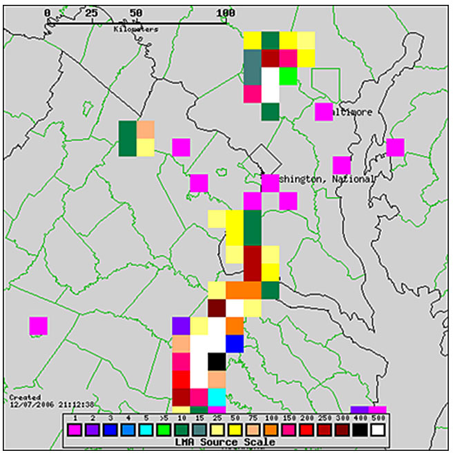 Example display of GLM proxy lightning data centered over the Sterling, Virginia NWS office.
The Geostationary Lightning Mapper Level 2 Lightning Detection product contains a list of lightning flashes, and their constituent groups and events. The definition of and relationship among flashes, groups, and events are governed by the following spatial and temporal characteristics: An event represents the signal detected from the cloud top associated with a lightning emission in an individual sensor pixel for a 2ms integration period; A group represents the events detected in adjacent sensor pixels for the same integration period as an event; A flash represents a series of measurements constrained by temporal and spatial extent thresholds that are associated with one or more groups. The parent, child relationship among specific flashes, groups, and events is stored in the product. Data for each flash includes an energy-weighted centroid latitude, longitude location, time span of occurrence, amount of radiant energy, and coverage area. Data for each group includes an energy-weighted centroid latitude, longitude location, mean time of occurrence, amount of radiant energy, and coverage area. Data for each event includes a latitude, longitude location, time of occurrence, and amount of radiant energy. The product includes data quality information for each flash and group. A Lightning Detection product file contains a set of flashes, and its constituent groups and events for a 20 second period. The units of measure for the flash, group, and event radiant energy values is Joules. The units of measure for the flash and group coverage areas is square meters.
- Cite as: GOES-R Algorithm Working Group and GOES-R Series Program, (2018): NOAA GOES-R Series Geostationary Lightning Mapper (GLM) Level 2 Lightning Detection: Events, Groups, and Flashes. [indicate subset used]. NOAA National Centers for Environmental Information. doi:10.7289/V5KH0KK6. [access date].
| Download Data |
|
| Order Data |
|
| Distribution Formats |
|
| Ordering Instructions |
Contact NCEI for other distribution options and instructions. |
| Distributor |
NOAA National Centers for Environmental Information
ncei.info@noaa.gov
|
| Dataset Point of Contact |
Customer Engagement Branch
DOC/NOAA/NESDIS/NCEI > National Centers for Environmental Information, NESDIS, NOAA, U.S. Department of Commerce
ncei.sat.info@noaa.gov
|
| Time Period |
2017-07-05 to Present (time interval: 1-second) |
| Spatial Reference System |
urn:ogc:def:crs:EPSG::4326 |
| Spatial Bounding Box Coordinates |
West: -141.56
East: -8.44
South: -66.56
North: 66.56
West: -203.56
East: -70.44
South: -66.56
North: 66.56
|
| Spatial Coverage Map |
|
| General Documentation |
|
| Processing Documents |
- GOES-R Algorithm Working Group
-
GOES-R Algorithm Working Group
The GOES-R Algorithm Working Group creates the algorithms that process the quality controlled satellite instrument data and produces resulting data products.
- NOAA Satellite Information System Product Quality
- GOES-R Algorithm Theoretical Basis Documents
|
| Associated Resources |
- Baseline Product - Lightning Detection: Events, Groups, and Flashes Webpage
- GOES Operational Status - NOAA Office of Satellite and Product Operations
- The GOES-R Geostationary Lightning Mapper (GLM).
-
Journal article published May 2013 by Elsevier (Atmospheric Research)
Goodman, S., Blakeslee, R., et al, (2013), The GOES-R Geostationary Lightning Mapper (GLM), Atm. Res., 125, 34–49, doi:10.1016/j.atmosres.2013.01.006.
- GOES-R Program Document Library
|
| Publication Dates |
|
| Data Presentation Form |
Digital image
|
| Dataset Progress Status |
Ongoing - data is continually being updated |
| Data Update Frequency |
Continual |
| Purpose |
Currently weather forecasters can use lightning data provided by a surface-based network to help "nowcast" severe weather. This is a valuable tool; however, it only has the capability of detecting cloud-to-ground flashes. The GOES-R satellites will have the capability to detect both cloud-to-ground and inter-cloud lightning, through use of the Geostationary Lightning Mapper (GLM). This will help severe weather forecasters identify thunderstorms which are rapidly intensifying, and enable them to issue accurate and timely severe thunderstorm and tornado warnings. |
| Use Limitations |
- For a list of use limitations of this dataset, see the product README and Algorithm Theoretical Basis Document (ATBD).
|
| Dataset Citation |
- Cite as: GOES-R Algorithm Working Group and GOES-R Series Program, (2018): NOAA GOES-R Series Geostationary Lightning Mapper (GLM) Level 2 Lightning Detection: Events, Groups, and Flashes. [indicate subset used]. NOAA National Centers for Environmental Information. doi:10.7289/V5KH0KK6. [access date].
|
| Cited Authors |
- GOES-R Algorithm Working Group
- GOES-R Series Program
|
| Principal Investigators |
- GOES-R Algorithm Working Group
|
| Resource Providers |
|
| Publishers |
- NOAA National Centers for Environmental Information
|
| Theme keywords |
Global Change Master Directory (GCMD) Science Keywords- Earth Science > Atmosphere > Atmospheric Electricity > Lightning
|
| Data Center keywords |
Global Change Master Directory (GCMD) Data Center Keywords
- DOC/NOAA/NESDIS/NCDC > National Climatic Data Center, NESDIS, NOAA, U.S. Department of Commerce
- DOC/NOAA/NESDIS/NCEI > National Centers for Environmental Information, NESDIS, NOAA, U.S. Department of Commerce
- DOC/NOAA/NESDIS/STAR > Center for Satellite Applications and Research, NESDIS, NOAA, U.S. Department of Commerce
- DOC/NOAA/NESDIS/OSPO > Office of Satellite and Product Operations, NESDIS, NOAA, U.S. Department of Commerce
|
| Platform keywords |
Global Change Master Directory (GCMD) Platform Keywords
- GOES-16 > Geostationary Operational Environmental Satellite 16
- GOES-17 > Geostationary Operational Environmental Satellite 17
- GOES-18 > Geostationary Operational Environmental Satellite 18
|
| Instrument keywords |
Global Change Master Directory (GCMD) Instrument Keywords- GLM > Geostationary Lightning Mapper
|
| Place keywords |
Global Change Master Directory (GCMD) Location Keywords
- Geographic Region > Equatorial
- Geographic Region > Mid-Latitude
- Geographic Region > Tropics
- Geographic Region > Northern Hemisphere
- Geographic Region > Southern Hemisphere
- Geographic Region > Western Hemisphere
- Continent > North America > United States Of America
- Continent > South America
- Continent > North America > Central America
- Ocean > Atlantic Ocean
- Ocean > Pacific Ocean
|
| Project keywords |
Global Change Master Directory (GCMD) Project Keywords- GOES > Geostationary Operational Environmental Satellites
NOAA STAR Central Data Repository (SCDR) Names
|
| Data Resolution keywords |
Global Change Master Directory (GCMD) Horizontal Data Resolution Keywords- 10 km - < 50 km or approximately .09 degree - < .5 degree
Global Change Master Directory (GCMD) Temporal Data Resolution Keywords
|
| Stratum keywords |
Global Change Master Directory (GCMD) Location Keywords
- Vertical Location > Troposphere
- Vertical Location > Land Surface
|
| Use Constraints |
- Cite as: GOES-R Algorithm Working Group and GOES-R Series Program, (2018): NOAA GOES-R Series Geostationary Lightning Mapper (GLM) Level 2 Lightning Detection: Events, Groups, and Flashes. [indicate subset used]. NOAA National Centers for Environmental Information. doi:10.7289/V5KH0KK6. [access date].
- Use liability: NOAA and NCEI cannot provide any warranty as to the accuracy, reliability, or completeness of furnished data. Users assume responsibility to determine the usability of these data. The user is responsible for the results of any application of this data for other than its intended purpose.
|
| Access Constraints |
- Distribution liability: NOAA and NCEI make no warranty, expressed or implied, regarding these data, nor does the fact of distribution constitute such a warranty. NOAA and NCEI cannot assume liability for any damages caused by any errors or omissions in these data. If appropriate, NCEI can only certify that the data it distributes are an authentic copy of the records that were accepted for inclusion in the NCEI archives.
|
| Fees |
- In most cases, electronic downloads of the data are free. However, fees may apply for custom orders, data certifications, copies of analog materials, and data distribution on physical media.
|
| Lineage information for: dataset |
|---|
| Lineage Statement |
The data were produced by the NOAA Office of Satellite and Product Operations (OSPO) and are archived at the NOAA National Centers for Environmental Information (NCEI). |
| Processor |
- DOC/NOAA/NESDIS/OSPO > Office of Satellite and Product Operations, NESDIS, NOAA, U.S. Department of Commerce
|
| Processing Steps |
- The Lightning Detection product is generated by the sequential execution of Level 0, Level 1b and Level 2+ ground processing algorithms.
- 2017-07-05T00:00:00 - The GOES-16 GLM Lightning Detection algorithm reached beta maturity.
- 2018-01-19T00:00:00 - The GOES-16 GLM Lightning Detection algorithm reached provisional maturity.
- 2018-11-08T00:00:00 - The GOES-16 GLM Lightning Detection algorithm reached full validation maturity.
- 2018-10-02T00:00:00 - The GOES-17 GLM Lightning Detection algorithm reached beta maturity.
- 2018-12-20T00:00:00 - The GOES-17 GLM Lightning Detection algorithm reached provisional maturity.
- 2019-11-21T00:00:00 - The GOES-17 GLM Lightning Detection algorithm reached full validation maturity.
|
| Processing Documents |
- GOES-R Algorithm Working Group
-
GOES-R Algorithm Working Group
The GOES-R Algorithm Working Group creates the algorithms that process the quality controlled satellite instrument data and produces resulting data products.
- NOAA Satellite Information System Product Quality
- GOES-R Algorithm Theoretical Basis Documents
|
| Source Datasets |
- NOAA GOES-R Series Geostationary Lightning Mapper (GLM) Aggregated L0 Data Packets
- Description of Source: Level 0 Raw Data
- Temporal extent used: 2017-07-05 to Present
- Spatial extent used: N:66.56 S:-66.56 E:-8.44 W:-141.56
|
| Lineage information for: repository |
|---|
| Processing Steps |
- 2015-04-22T00:00:00 - NOAA created the National Centers for Environmental Information (NCEI) by merging NOAA's National Climatic Data Center (NCDC), National Geophysical Data Center (NGDC), and National Oceanographic Data Center (NODC), including the National Coastal Data Development Center (NCDDC), per the Consolidated and Further Continuing Appropriations Act, 2015, Public Law 113-235. NCEI launched publicly on April 22, 2015.
|
Last Modified: 2023-10-19
For questions about the information on this page, please email:
ncei.info@noaa.gov